


MyRadar
@myradar.bsky.social
Keeping you ahead of the storm since 2008. Download for FREE! myradar.com
JUST IN: A 7.6 magnitude earthquake struck just off the coast of northeastern Japan.
The JMA has issued tsunami alerts.
The JMA has issued tsunami alerts.


December 8, 2025 at 3:01 PM
JUST IN: A 7.6 magnitude earthquake struck just off the coast of northeastern Japan.
The JMA has issued tsunami alerts.
The JMA has issued tsunami alerts.
🌧️A sneaky freezing rain/drizzle setup is coming together for Friday night in Washington D.C., Baltimore, and surrounding areas.
A glaze of ice accretion will make for dangerous travel.
MyRadar meteorologist @matthewcappucci.bsky.social has an update.
myradar.com/videos/6277
A glaze of ice accretion will make for dangerous travel.
MyRadar meteorologist @matthewcappucci.bsky.social has an update.
myradar.com/videos/6277

Freezing drizzle in Mid-Atlantic
A sneaky freezing rain/drizzle setup is coming together for Friday night in Washington D.C., Baltimore, and surrounding areas. A glaze of ice accretion will make for dangerous travel. MyRadar meteorol...
myradar.com
December 5, 2025 at 9:34 PM
🌧️A sneaky freezing rain/drizzle setup is coming together for Friday night in Washington D.C., Baltimore, and surrounding areas.
A glaze of ice accretion will make for dangerous travel.
MyRadar meteorologist @matthewcappucci.bsky.social has an update.
myradar.com/videos/6277
A glaze of ice accretion will make for dangerous travel.
MyRadar meteorologist @matthewcappucci.bsky.social has an update.
myradar.com/videos/6277
DMV gang – please share! INCREASING risk of freezing drizzle developing between 7 p.m. and 1 a.m. overnight TONIGHT! Very slick travel possible.
Drizzle freezes FASTER than rain due to higher surface area/volume ratio with tiny droplets.
Freezing fog/mist likely too!
Drizzle freezes FASTER than rain due to higher surface area/volume ratio with tiny droplets.
Freezing fog/mist likely too!

December 5, 2025 at 7:26 PM
DMV gang – please share! INCREASING risk of freezing drizzle developing between 7 p.m. and 1 a.m. overnight TONIGHT! Very slick travel possible.
Drizzle freezes FASTER than rain due to higher surface area/volume ratio with tiny droplets.
Freezing fog/mist likely too!
Drizzle freezes FASTER than rain due to higher surface area/volume ratio with tiny droplets.
Freezing fog/mist likely too!
Senior meteorologist @MatthewCappucci recently visited Chestertown College, where he delivered a guest lecture on the science of tornadoes.
“He is an amazing communicator of science … and it has been very surreal to have him here,” Dr. Karl Kehm told The Elm.
“He is an amazing communicator of science … and it has been very surreal to have him here,” Dr. Karl Kehm told The Elm.

December 4, 2025 at 7:27 PM
Senior meteorologist @MatthewCappucci recently visited Chestertown College, where he delivered a guest lecture on the science of tornadoes.
“He is an amazing communicator of science … and it has been very surreal to have him here,” Dr. Karl Kehm told The Elm.
“He is an amazing communicator of science … and it has been very surreal to have him here,” Dr. Karl Kehm told The Elm.
YIKES. Can you imagine!? Parts of Alaska and Yukon Canada could face temperatures of minus-40º to minus-50ºF late next week!
"As winds diminish toward the early to
middle part of next week, valley temperatures in the 40s and 50s below zero are not out of the question."
– NWS
"As winds diminish toward the early to
middle part of next week, valley temperatures in the 40s and 50s below zero are not out of the question."
– NWS

December 4, 2025 at 6:30 PM
YIKES. Can you imagine!? Parts of Alaska and Yukon Canada could face temperatures of minus-40º to minus-50ºF late next week!
"As winds diminish toward the early to
middle part of next week, valley temperatures in the 40s and 50s below zero are not out of the question."
– NWS
"As winds diminish toward the early to
middle part of next week, valley temperatures in the 40s and 50s below zero are not out of the question."
– NWS
We're monitoring the potential for an active mid-December and pre-holiday period across the eastern United States.
Colder than average temperatures are likely, with an increased risk of winter weather and/or storms.
Colder than average temperatures are likely, with an increased risk of winter weather and/or storms.

December 4, 2025 at 5:57 PM
We're monitoring the potential for an active mid-December and pre-holiday period across the eastern United States.
Colder than average temperatures are likely, with an increased risk of winter weather and/or storms.
Colder than average temperatures are likely, with an increased risk of winter weather and/or storms.
🌨️The first winter storm of the season is working into New England, producing significant inland snows. Totals of 6-10 inches are likely.
🌧️At the coast, primarily rain is likely. Isolated thundersnow is possible in Downeast Maine.
@matthewcappucci.bsky.social has an update.
myradar.com/videos/6276
🌧️At the coast, primarily rain is likely. Isolated thundersnow is possible in Downeast Maine.
@matthewcappucci.bsky.social has an update.
myradar.com/videos/6276

New England Nor’easter
The first winter storm of the season is working into New England, producing significant inland snows. Totals of 6 to 10 inches are likely. At the coast, primarily rain is likely. Isolated thundersnow ...
myradar.com
December 2, 2025 at 6:00 PM
🌨️The first winter storm of the season is working into New England, producing significant inland snows. Totals of 6-10 inches are likely.
🌧️At the coast, primarily rain is likely. Isolated thundersnow is possible in Downeast Maine.
@matthewcappucci.bsky.social has an update.
myradar.com/videos/6276
🌧️At the coast, primarily rain is likely. Isolated thundersnow is possible in Downeast Maine.
@matthewcappucci.bsky.social has an update.
myradar.com/videos/6276
Here's how much snow is left to fall in New England:

December 2, 2025 at 5:20 PM
Here's how much snow is left to fall in New England:
Maybe a lil' bit of thundersnow across Downeast Maine this evening? 👀
Will be intrigued to see if any cloud to ground bolts can strike the Bull Hill Wind farm owned by Hancock Wind in Franklin, Maine.
Will be intrigued to see if any cloud to ground bolts can strike the Bull Hill Wind farm owned by Hancock Wind in Franklin, Maine.


December 2, 2025 at 5:11 PM
Maybe a lil' bit of thundersnow across Downeast Maine this evening? 👀
Will be intrigued to see if any cloud to ground bolts can strike the Bull Hill Wind farm owned by Hancock Wind in Franklin, Maine.
Will be intrigued to see if any cloud to ground bolts can strike the Bull Hill Wind farm owned by Hancock Wind in Franklin, Maine.
❄️A significant winter storm will develop beginning Monday night, then track up the Appalachians while impacting the eastern U.S.
Accumulating snows are likely from Kentucky to Maine, with icing along Interstate 81.
Meteorologist @matthewcappucci.bsky.social has an update.
myradar.com/videos/6275
Accumulating snows are likely from Kentucky to Maine, with icing along Interstate 81.
Meteorologist @matthewcappucci.bsky.social has an update.
myradar.com/videos/6275
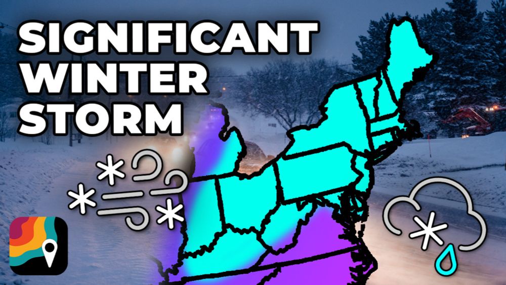
Eastern U.S. Winter Storm
A significant winter storm will develop beginning Monday night, then track up the Appalachians while impacting the eastern U.S. Accumulating snows are likely from Kentucky to Maine, with icing along I...
myradar.com
December 1, 2025 at 6:35 PM
❄️A significant winter storm will develop beginning Monday night, then track up the Appalachians while impacting the eastern U.S.
Accumulating snows are likely from Kentucky to Maine, with icing along Interstate 81.
Meteorologist @matthewcappucci.bsky.social has an update.
myradar.com/videos/6275
Accumulating snows are likely from Kentucky to Maine, with icing along Interstate 81.
Meteorologist @matthewcappucci.bsky.social has an update.
myradar.com/videos/6275
Here's a look at expected ice accretions in western Virginia and eastern West Virginia.
Locally up to a quarter inch. That will cause slick and dangerous travel.
It may LOOK wet but really be ice.
Locally up to a quarter inch. That will cause slick and dangerous travel.
It may LOOK wet but really be ice.

December 1, 2025 at 5:15 PM
Here's a look at expected ice accretions in western Virginia and eastern West Virginia.
Locally up to a quarter inch. That will cause slick and dangerous travel.
It may LOOK wet but really be ice.
Locally up to a quarter inch. That will cause slick and dangerous travel.
It may LOOK wet but really be ice.
Classic freezing rain sounding (profile) in western Virginia for Tuesday morning.
A "warm nose" at the mid levels guarantees liquid falls, but freezing/subfreezing surface layer promotes freezing and ice accretion at ground.
A "warm nose" at the mid levels guarantees liquid falls, but freezing/subfreezing surface layer promotes freezing and ice accretion at ground.

December 1, 2025 at 5:15 PM
Classic freezing rain sounding (profile) in western Virginia for Tuesday morning.
A "warm nose" at the mid levels guarantees liquid falls, but freezing/subfreezing surface layer promotes freezing and ice accretion at ground.
A "warm nose" at the mid levels guarantees liquid falls, but freezing/subfreezing surface layer promotes freezing and ice accretion at ground.
Growing concern for the I-81 corridor in western Virginia on Tuesday morning, as well as the Alleghenies of eastern West Virginia.
Freezing rain/freezing drizzle will make for very treacherous travel.
Freezing rain/freezing drizzle will make for very treacherous travel.

December 1, 2025 at 5:14 PM
Growing concern for the I-81 corridor in western Virginia on Tuesday morning, as well as the Alleghenies of eastern West Virginia.
Freezing rain/freezing drizzle will make for very treacherous travel.
Freezing rain/freezing drizzle will make for very treacherous travel.
Freezing rain is moving through the Little Rock metro as anticipated. Please drive cautiously!
It may LOOK wet, but actually be ice.
It may LOOK wet, but actually be ice.

December 1, 2025 at 3:41 PM
Freezing rain is moving through the Little Rock metro as anticipated. Please drive cautiously!
It may LOOK wet, but actually be ice.
It may LOOK wet, but actually be ice.
We are growing concerned about the Interstate 81 in western Virginia and even extreme northeast Tennessee on Tuesday. Warm mid-level temperatures will allow rain to fall, BUT it will freeze on contact with the ground thanks to subfreezing surface temperatures. That will make for dangerous travel.

December 1, 2025 at 2:28 PM
We are growing concerned about the Interstate 81 in western Virginia and even extreme northeast Tennessee on Tuesday. Warm mid-level temperatures will allow rain to fall, BUT it will freeze on contact with the ground thanks to subfreezing surface temperatures. That will make for dangerous travel.
Hefty snow totals with this last system! Here’s a rundown of amounts:


November 30, 2025 at 2:37 PM
Hefty snow totals with this last system! Here’s a rundown of amounts:
THUNDERSNOW! If you live in southern/central Illinois or Indiana, don’t go out to shovel until the snow tapers down Saturday evening. LIGHTNING is occurring and is hitting the ground.

November 29, 2025 at 8:08 PM
THUNDERSNOW! If you live in southern/central Illinois or Indiana, don’t go out to shovel until the snow tapers down Saturday evening. LIGHTNING is occurring and is hitting the ground.
NEBRASKA and IOWA folks – FREEZING RAIN likely this evening for Omaha, Lincoln and Council Bluffs! It’s a bit warm upstairs, so rain will fall initially, but the ground is below freezing. That will allow raindrops to quickly freeze.

November 28, 2025 at 4:56 PM
NEBRASKA and IOWA folks – FREEZING RAIN likely this evening for Omaha, Lincoln and Council Bluffs! It’s a bit warm upstairs, so rain will fall initially, but the ground is below freezing. That will allow raindrops to quickly freeze.
Winter storm WARNINGS now cover Chicago, Madison, Milwaukee, Green Bay, Springfield, Peoria, Sioux Falls… virtually everyone getting 6-10 inches of snow out of this, and some folks seeing 12+ inches, especially in Iowa!
Be to your destination tonight. Travel will be a nightmare at O’Hare.
Be to your destination tonight. Travel will be a nightmare at O’Hare.

November 28, 2025 at 4:41 PM
Winter storm WARNINGS now cover Chicago, Madison, Milwaukee, Green Bay, Springfield, Peoria, Sioux Falls… virtually everyone getting 6-10 inches of snow out of this, and some folks seeing 12+ inches, especially in Iowa!
Be to your destination tonight. Travel will be a nightmare at O’Hare.
Be to your destination tonight. Travel will be a nightmare at O’Hare.
UPDATE: Amounts have INCREASED for virtually everyone on the map since yesterday. This is the National Weather Service’s forecast.
Snow begins this evening in Iowa and reaches Chicago by daybreak. Be where you need to be by sunset tonight, because you do NOT want to travel Saturday.
Snow begins this evening in Iowa and reaches Chicago by daybreak. Be where you need to be by sunset tonight, because you do NOT want to travel Saturday.

November 28, 2025 at 4:28 PM
UPDATE: Amounts have INCREASED for virtually everyone on the map since yesterday. This is the National Weather Service’s forecast.
Snow begins this evening in Iowa and reaches Chicago by daybreak. Be where you need to be by sunset tonight, because you do NOT want to travel Saturday.
Snow begins this evening in Iowa and reaches Chicago by daybreak. Be where you need to be by sunset tonight, because you do NOT want to travel Saturday.
This map shows the National Weather Service’s forecast snow totals. In Iowa, there’s a chance that even higher totals area realized.
Confidence is increasing for 8+ inches in Chicago and Madison, the bulk of which falls on Saturday.
For Indianapolis and Columbus, amounts walk a tightrope.
Confidence is increasing for 8+ inches in Chicago and Madison, the bulk of which falls on Saturday.
For Indianapolis and Columbus, amounts walk a tightrope.

November 27, 2025 at 11:35 PM
This map shows the National Weather Service’s forecast snow totals. In Iowa, there’s a chance that even higher totals area realized.
Confidence is increasing for 8+ inches in Chicago and Madison, the bulk of which falls on Saturday.
For Indianapolis and Columbus, amounts walk a tightrope.
Confidence is increasing for 8+ inches in Chicago and Madison, the bulk of which falls on Saturday.
For Indianapolis and Columbus, amounts walk a tightrope.
November 27, 2025 at 11:34 PM
This map shows the National Weather Service’s forecast snow totals. In Iowa, there’s a chance that even higher totals area realized.
Confidence is increasing for 8+ inches in Chicago and Madison, the bulk of which falls on Saturday.
For Indianapolis and Columbus, amounts walk a tightrope.
Confidence is increasing for 8+ inches in Chicago and Madison, the bulk of which falls on Saturday.
For Indianapolis and Columbus, amounts walk a tightrope.
Here we go! SIGNIFICANT winter storm shaping up for much of the northern U.S., Northern Plains, Corn Belt, Upper Midwest and Great Lakes.

November 27, 2025 at 11:00 PM
Here we go! SIGNIFICANT winter storm shaping up for much of the northern U.S., Northern Plains, Corn Belt, Upper Midwest and Great Lakes.
Confidence is HIGH in a significant snowstorm for parts of the Corn Belt and Midwest this weekend. The storm system will tap into Gulf moisture working northward, leading to a strip of 8 to 12 inches of snow. Locally greater totals are possible.

November 27, 2025 at 6:07 PM
Confidence is HIGH in a significant snowstorm for parts of the Corn Belt and Midwest this weekend. The storm system will tap into Gulf moisture working northward, leading to a strip of 8 to 12 inches of snow. Locally greater totals are possible.
Confidence is HIGH in a significant snowstorm for parts of the Corn Belt and Midwest this weekend.
The main wildcard? Where exactly does the low pressure center track? That will determine where the rain/snow sets up.
That makes northern Missouri a challenging forecast.
The main wildcard? Where exactly does the low pressure center track? That will determine where the rain/snow sets up.
That makes northern Missouri a challenging forecast.

November 27, 2025 at 6:01 PM
Confidence is HIGH in a significant snowstorm for parts of the Corn Belt and Midwest this weekend.
The main wildcard? Where exactly does the low pressure center track? That will determine where the rain/snow sets up.
That makes northern Missouri a challenging forecast.
The main wildcard? Where exactly does the low pressure center track? That will determine where the rain/snow sets up.
That makes northern Missouri a challenging forecast.