


MyRadar
@myradar.bsky.social
Keeping you ahead of the storm since 2008. Download for FREE! myradar.com
Here's how much snow is left to fall in New England:

December 2, 2025 at 5:20 PM
Here's how much snow is left to fall in New England:
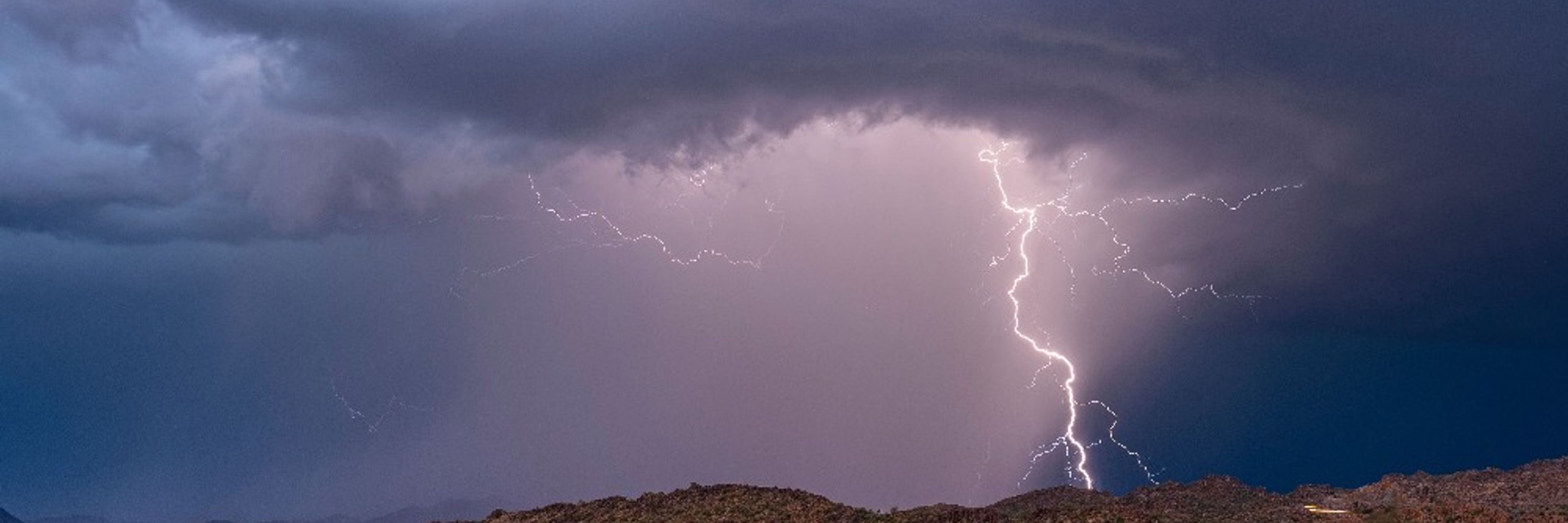
Maybe a lil' bit of thundersnow across Downeast Maine this evening? 👀
Will be intrigued to see if any cloud to ground bolts can strike the Bull Hill Wind farm owned by Hancock Wind in Franklin, Maine.
Will be intrigued to see if any cloud to ground bolts can strike the Bull Hill Wind farm owned by Hancock Wind in Franklin, Maine.


December 2, 2025 at 5:11 PM
Maybe a lil' bit of thundersnow across Downeast Maine this evening? 👀
Will be intrigued to see if any cloud to ground bolts can strike the Bull Hill Wind farm owned by Hancock Wind in Franklin, Maine.
Will be intrigued to see if any cloud to ground bolts can strike the Bull Hill Wind farm owned by Hancock Wind in Franklin, Maine.
Here's a look at expected ice accretions in western Virginia and eastern West Virginia.
Locally up to a quarter inch. That will cause slick and dangerous travel.
It may LOOK wet but really be ice.
Locally up to a quarter inch. That will cause slick and dangerous travel.
It may LOOK wet but really be ice.

December 1, 2025 at 5:15 PM
Here's a look at expected ice accretions in western Virginia and eastern West Virginia.
Locally up to a quarter inch. That will cause slick and dangerous travel.
It may LOOK wet but really be ice.
Locally up to a quarter inch. That will cause slick and dangerous travel.
It may LOOK wet but really be ice.
Classic freezing rain sounding (profile) in western Virginia for Tuesday morning.
A "warm nose" at the mid levels guarantees liquid falls, but freezing/subfreezing surface layer promotes freezing and ice accretion at ground.
A "warm nose" at the mid levels guarantees liquid falls, but freezing/subfreezing surface layer promotes freezing and ice accretion at ground.

December 1, 2025 at 5:15 PM
Classic freezing rain sounding (profile) in western Virginia for Tuesday morning.
A "warm nose" at the mid levels guarantees liquid falls, but freezing/subfreezing surface layer promotes freezing and ice accretion at ground.
A "warm nose" at the mid levels guarantees liquid falls, but freezing/subfreezing surface layer promotes freezing and ice accretion at ground.
Growing concern for the I-81 corridor in western Virginia on Tuesday morning, as well as the Alleghenies of eastern West Virginia.
Freezing rain/freezing drizzle will make for very treacherous travel.
Freezing rain/freezing drizzle will make for very treacherous travel.

December 1, 2025 at 5:14 PM
Growing concern for the I-81 corridor in western Virginia on Tuesday morning, as well as the Alleghenies of eastern West Virginia.
Freezing rain/freezing drizzle will make for very treacherous travel.
Freezing rain/freezing drizzle will make for very treacherous travel.
Freezing rain is moving through the Little Rock metro as anticipated. Please drive cautiously!
It may LOOK wet, but actually be ice.
It may LOOK wet, but actually be ice.

December 1, 2025 at 3:41 PM
Freezing rain is moving through the Little Rock metro as anticipated. Please drive cautiously!
It may LOOK wet, but actually be ice.
It may LOOK wet, but actually be ice.
We are growing concerned about the Interstate 81 in western Virginia and even extreme northeast Tennessee on Tuesday. Warm mid-level temperatures will allow rain to fall, BUT it will freeze on contact with the ground thanks to subfreezing surface temperatures. That will make for dangerous travel.

December 1, 2025 at 2:28 PM
We are growing concerned about the Interstate 81 in western Virginia and even extreme northeast Tennessee on Tuesday. Warm mid-level temperatures will allow rain to fall, BUT it will freeze on contact with the ground thanks to subfreezing surface temperatures. That will make for dangerous travel.
Hefty snow totals with this last system! Here’s a rundown of amounts:


November 30, 2025 at 2:37 PM
Hefty snow totals with this last system! Here’s a rundown of amounts:
THUNDERSNOW! If you live in southern/central Illinois or Indiana, don’t go out to shovel until the snow tapers down Saturday evening. LIGHTNING is occurring and is hitting the ground.

November 29, 2025 at 8:08 PM
THUNDERSNOW! If you live in southern/central Illinois or Indiana, don’t go out to shovel until the snow tapers down Saturday evening. LIGHTNING is occurring and is hitting the ground.
NEBRASKA and IOWA folks – FREEZING RAIN likely this evening for Omaha, Lincoln and Council Bluffs! It’s a bit warm upstairs, so rain will fall initially, but the ground is below freezing. That will allow raindrops to quickly freeze.

November 28, 2025 at 4:56 PM
NEBRASKA and IOWA folks – FREEZING RAIN likely this evening for Omaha, Lincoln and Council Bluffs! It’s a bit warm upstairs, so rain will fall initially, but the ground is below freezing. That will allow raindrops to quickly freeze.
Winter storm WARNINGS now cover Chicago, Madison, Milwaukee, Green Bay, Springfield, Peoria, Sioux Falls… virtually everyone getting 6-10 inches of snow out of this, and some folks seeing 12+ inches, especially in Iowa!
Be to your destination tonight. Travel will be a nightmare at O’Hare.
Be to your destination tonight. Travel will be a nightmare at O’Hare.

November 28, 2025 at 4:41 PM
Winter storm WARNINGS now cover Chicago, Madison, Milwaukee, Green Bay, Springfield, Peoria, Sioux Falls… virtually everyone getting 6-10 inches of snow out of this, and some folks seeing 12+ inches, especially in Iowa!
Be to your destination tonight. Travel will be a nightmare at O’Hare.
Be to your destination tonight. Travel will be a nightmare at O’Hare.
UPDATE: Amounts have INCREASED for virtually everyone on the map since yesterday. This is the National Weather Service’s forecast.
Snow begins this evening in Iowa and reaches Chicago by daybreak. Be where you need to be by sunset tonight, because you do NOT want to travel Saturday.
Snow begins this evening in Iowa and reaches Chicago by daybreak. Be where you need to be by sunset tonight, because you do NOT want to travel Saturday.

November 28, 2025 at 4:28 PM
UPDATE: Amounts have INCREASED for virtually everyone on the map since yesterday. This is the National Weather Service’s forecast.
Snow begins this evening in Iowa and reaches Chicago by daybreak. Be where you need to be by sunset tonight, because you do NOT want to travel Saturday.
Snow begins this evening in Iowa and reaches Chicago by daybreak. Be where you need to be by sunset tonight, because you do NOT want to travel Saturday.
This map shows the National Weather Service’s forecast snow totals. In Iowa, there’s a chance that even higher totals area realized.
Confidence is increasing for 8+ inches in Chicago and Madison, the bulk of which falls on Saturday.
For Indianapolis and Columbus, amounts walk a tightrope.
Confidence is increasing for 8+ inches in Chicago and Madison, the bulk of which falls on Saturday.
For Indianapolis and Columbus, amounts walk a tightrope.

November 27, 2025 at 11:35 PM
This map shows the National Weather Service’s forecast snow totals. In Iowa, there’s a chance that even higher totals area realized.
Confidence is increasing for 8+ inches in Chicago and Madison, the bulk of which falls on Saturday.
For Indianapolis and Columbus, amounts walk a tightrope.
Confidence is increasing for 8+ inches in Chicago and Madison, the bulk of which falls on Saturday.
For Indianapolis and Columbus, amounts walk a tightrope.
November 27, 2025 at 11:34 PM
This map shows the National Weather Service’s forecast snow totals. In Iowa, there’s a chance that even higher totals area realized.
Confidence is increasing for 8+ inches in Chicago and Madison, the bulk of which falls on Saturday.
For Indianapolis and Columbus, amounts walk a tightrope.
Confidence is increasing for 8+ inches in Chicago and Madison, the bulk of which falls on Saturday.
For Indianapolis and Columbus, amounts walk a tightrope.
Here we go! SIGNIFICANT winter storm shaping up for much of the northern U.S., Northern Plains, Corn Belt, Upper Midwest and Great Lakes.

November 27, 2025 at 11:00 PM
Here we go! SIGNIFICANT winter storm shaping up for much of the northern U.S., Northern Plains, Corn Belt, Upper Midwest and Great Lakes.
Confidence is HIGH in a significant snowstorm for parts of the Corn Belt and Midwest this weekend. The storm system will tap into Gulf moisture working northward, leading to a strip of 8 to 12 inches of snow. Locally greater totals are possible.

November 27, 2025 at 6:07 PM
Confidence is HIGH in a significant snowstorm for parts of the Corn Belt and Midwest this weekend. The storm system will tap into Gulf moisture working northward, leading to a strip of 8 to 12 inches of snow. Locally greater totals are possible.
Confidence is HIGH in a significant snowstorm for parts of the Corn Belt and Midwest this weekend.
The main wildcard? Where exactly does the low pressure center track? That will determine where the rain/snow sets up.
That makes northern Missouri a challenging forecast.
The main wildcard? Where exactly does the low pressure center track? That will determine where the rain/snow sets up.
That makes northern Missouri a challenging forecast.

November 27, 2025 at 6:01 PM
Confidence is HIGH in a significant snowstorm for parts of the Corn Belt and Midwest this weekend.
The main wildcard? Where exactly does the low pressure center track? That will determine where the rain/snow sets up.
That makes northern Missouri a challenging forecast.
The main wildcard? Where exactly does the low pressure center track? That will determine where the rain/snow sets up.
That makes northern Missouri a challenging forecast.
Confidence is increasing in the likelihood of a significant winter storm across portions of the Corn Belt, Midwest and Great Lakes this weekend. In Iowa and northwest Illinois, a foot of snow is possible. Elsewhere, plowable snows will hamper post-Thanksgiving return travel.

November 27, 2025 at 4:53 PM
Confidence is increasing in the likelihood of a significant winter storm across portions of the Corn Belt, Midwest and Great Lakes this weekend. In Iowa and northwest Illinois, a foot of snow is possible. Elsewhere, plowable snows will hamper post-Thanksgiving return travel.
Seiche ongoing! Check out this graphic showing water levels dropping on the west side of Lake Erie while they rise near Buffalo!

November 26, 2025 at 9:26 PM
Seiche ongoing! Check out this graphic showing water levels dropping on the west side of Lake Erie while they rise near Buffalo!
Seiche ongoing! Check out this graphic showing water levels dropping on the west side of Lake Erie while they rise near Buffalo!
November 26, 2025 at 9:26 PM
Seiche ongoing! Check out this graphic showing water levels dropping on the west side of Lake Erie while they rise near Buffalo!
Lake-effect snows will persist through Friday off Lakes Erie and Ontario...
...BUT the bands will only hover over a given area for 8-12 hours before pivoting, precluding a more significant event.
...BUT the bands will only hover over a given area for 8-12 hours before pivoting, precluding a more significant event.

November 26, 2025 at 6:06 PM
Lake-effect snows will persist through Friday off Lakes Erie and Ontario...
...BUT the bands will only hover over a given area for 8-12 hours before pivoting, precluding a more significant event.
...BUT the bands will only hover over a given area for 8-12 hours before pivoting, precluding a more significant event.
Strong winds will push water to the east end of Lake Erie, causing up to a 6 foot rise in water levels.
There could be some pockets of flooding near Buffalo.
There could be some pockets of flooding near Buffalo.


November 26, 2025 at 4:49 PM
Strong winds will push water to the east end of Lake Erie, causing up to a 6 foot rise in water levels.
There could be some pockets of flooding near Buffalo.
There could be some pockets of flooding near Buffalo.
Models showing some concerning trends for this afternoon, with redevelopment of potentially tornadic supercells in Alabama.
New rotating storms fire as early as noontime.
New rotating storms fire as early as noontime.
November 25, 2025 at 9:26 PM
Models showing some concerning trends for this afternoon, with redevelopment of potentially tornadic supercells in Alabama.
New rotating storms fire as early as noontime.
New rotating storms fire as early as noontime.
Midnight tonight, a cold front will sweep through Chicago. That will introduce strong west-northwesterly winds of 45+ mph as temperatures drop.
Snow will be moderate in northern Wisconsin.
By Wednesday morning, snow showers are pinwheeling into Chicago and Lower Michigan.
Snow will be moderate in northern Wisconsin.
By Wednesday morning, snow showers are pinwheeling into Chicago and Lower Michigan.

November 25, 2025 at 1:33 PM
Midnight tonight, a cold front will sweep through Chicago. That will introduce strong west-northwesterly winds of 45+ mph as temperatures drop.
Snow will be moderate in northern Wisconsin.
By Wednesday morning, snow showers are pinwheeling into Chicago and Lower Michigan.
Snow will be moderate in northern Wisconsin.
By Wednesday morning, snow showers are pinwheeling into Chicago and Lower Michigan.
Two cities we're watching for travel issues – Atlanta, where severe weather will ramp up, especially this afternoon... and Chicago, where strong winds could cause flight problems.
Check with your air carrier if you're flying through ORD, MDW or ATL.
Check with your air carrier if you're flying through ORD, MDW or ATL.

November 25, 2025 at 1:32 PM
Two cities we're watching for travel issues – Atlanta, where severe weather will ramp up, especially this afternoon... and Chicago, where strong winds could cause flight problems.
Check with your air carrier if you're flying through ORD, MDW or ATL.
Check with your air carrier if you're flying through ORD, MDW or ATL.