


Urban History Association (the official account)
@urbanhistorya.bsky.social
If you're into cities and their histories, then you're into the Urban History Association!
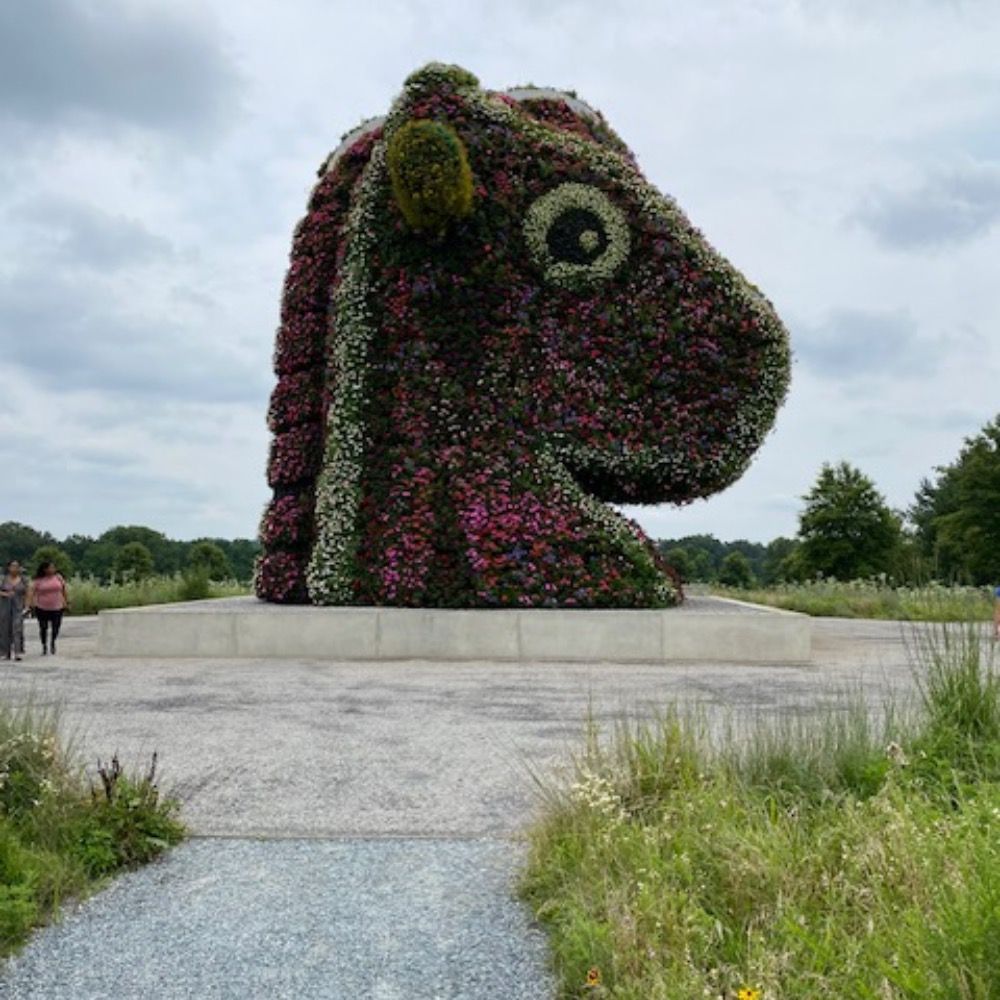
“As with many long-term urban planning projects, and the delicate balance between preservation and progress, Tokyo confronts an identity crisis that is fundamentally an iteration of the same tensions that marked Japan’s entrance into modernity”

Into the Woods: Meiji Jingu and the Hunger for Modernity
Editor’s note: This is our final entry in The Metropole theme for November 2025, Metropolitan Consumption. To see additional posts on the theme from November, see here. By Emi Higashiyama Tok…
themetropole.blog
November 25, 2025 at 3:02 PM
“As with many long-term urban planning projects, and the delicate balance between preservation and progress, Tokyo confronts an identity crisis that is fundamentally an iteration of the same tensions that marked Japan’s entrance into modernity”
Reposted by Urban History Association (the official account)
With the semiquincentennial behind us, launching the next 250 with my 251st #ScholarSunday thread of great public scholarly writing & work, podcast episodes, new & forthcoming books from the last week. Add more below, share as widely as possible, & enjoy, all! 🗃️
blackwhiteandread.com/scholarsunda...
blackwhiteandread.com/scholarsunda...

#ScholarSunday Thread 251 (11/23/25) – Black and White and Read All Over
With the semiquincentennial behind us, launching the next 250 with my 251st #ScholarSunday thread of great public scholarly writing & work, podcast episodes, new & forthcoming books from the last week...
blackwhiteandread.com
November 23, 2025 at 12:56 PM
With the semiquincentennial behind us, launching the next 250 with my 251st #ScholarSunday thread of great public scholarly writing & work, podcast episodes, new & forthcoming books from the last week. Add more below, share as widely as possible, & enjoy, all! 🗃️
blackwhiteandread.com/scholarsunda...
blackwhiteandread.com/scholarsunda...
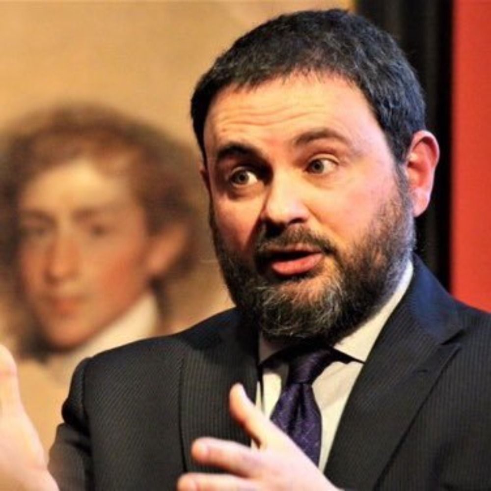
"Why Nothing Works is a plea for progressives to zoom out for a second and register that their own ideology is more complex and, in many cases, contradictory." The Metropole sat down with Marc J. Dunkelman to discuss his 2025 book Why Nothin Works and its relationship to urban history.

Why Nothing Works: A Q & A with Marc J. Dunkelman
In Why Nothing Works: Who Killed Progress – And How to Bring It Back, Marc J. Dunkelman argues that well-intentioned efforts by progressives have contributed to “render[ing] government incompetent.…
themetropole.blog
November 20, 2025 at 2:31 PM
"Why Nothing Works is a plea for progressives to zoom out for a second and register that their own ideology is more complex and, in many cases, contradictory." The Metropole sat down with Marc J. Dunkelman to discuss his 2025 book Why Nothin Works and its relationship to urban history.
"Emerging as first a savior, and later the man responsible for driving the city deeper into economic despair, was a charismatic politician with a penchant for sweets and cigarettes named Larry Langford." David Bruno on Birmingham's failed attempts and rebranding.
themetropole.blog/2025/11/18/i...
themetropole.blog/2025/11/18/i...

“If Atlanta Can Have Beluga Whale, We Can Have One Too”: Larry Langford and the Struggle to Save the Magic City
Editor’s note: This is the fourth post for our November theme month, Metropolitan Consumption. You can see additional posts from the month here. See also David Bruno’s piece here from T…
themetropole.blog
November 18, 2025 at 2:45 PM
"Emerging as first a savior, and later the man responsible for driving the city deeper into economic despair, was a charismatic politician with a penchant for sweets and cigarettes named Larry Langford." David Bruno on Birmingham's failed attempts and rebranding.
themetropole.blog/2025/11/18/i...
themetropole.blog/2025/11/18/i...
Reposted by Urban History Association (the official account)
Here it is, a very special--& especially supersized—250th #ScholarSunday thread of great public scholarly writing & work, podcast episodes, new & forthcoming books from the last week. Please add more below, share as widely as possible, & enjoy, all! 🗃️
blackwhiteandread.com/scholarsunda...
blackwhiteandread.com/scholarsunda...
#ScholarSunday Thread 250! (11/16/25) – Black and White and Read All Over
Here it is, a very special--& especially supersized—250th #ScholarSunday thread of great public scholarly writing & work, podcast episodes, new & forthcoming books from the last week. Please add more ...
blackwhiteandread.com
November 16, 2025 at 12:59 PM
Here it is, a very special--& especially supersized—250th #ScholarSunday thread of great public scholarly writing & work, podcast episodes, new & forthcoming books from the last week. Please add more below, share as widely as possible, & enjoy, all! 🗃️
blackwhiteandread.com/scholarsunda...
blackwhiteandread.com/scholarsunda...
Reposted by Urban History Association (the official account)

This month I feature @placesjournal.bsky.social, @urbanhistorya.bsky.social, @charlotte-leib.bsky.social, @ginastar.bsky.social, @miskoaki.bsky.social, and more!
#envhist
#envhist
Our editor-in-chief, @jessicamdewitt.bsky.social, is back with her picks for environmental history worth reading (and watching) from October!
niche-canada.org/2025/11/14/e...
#envhist
niche-canada.org/2025/11/14/e...
#envhist

#EnvHist Worth Reading: October 2025
Find a landslide, urban light pollution, and unfulfilled treaty promises in the latest list of environmental history worth reading from Jessica DeWitt.
niche-canada.org
November 14, 2025 at 6:44 PM
This month I feature @placesjournal.bsky.social, @urbanhistorya.bsky.social, @charlotte-leib.bsky.social, @ginastar.bsky.social, @miskoaki.bsky.social, and more!
#envhist
#envhist
Reposted by Urban History Association (the official account)
I was super happy to read and edit this entry in @urbanhistorya.bsky.social’s #MetropolitanConsumption theme for November. One of my favorite pieces we’ve published.
For us midwestern folk, Wisconsin Dells occupies a storied place in our summer vacations, but it has come at a cost as the tourist attraction has been devouring water in the region and obscuring other worthy forms of tourism around the Dells. Matthew King's deep dive (zing!) into the Dells

How the Wisconsin Dells Turned Nature Into the Ultimate Indoor Destination
Editor’s note: This is the third installment in The Metropole’s theme for November: Metropolitan Consumption. By Matthew King On any given day, in any season or weather, the Wisconsin D…
themetropole.blog
November 11, 2025 at 2:43 PM
I was super happy to read and edit this entry in @urbanhistorya.bsky.social’s #MetropolitanConsumption theme for November. One of my favorite pieces we’ve published.
For us midwestern folk, Wisconsin Dells occupies a storied place in our summer vacations, but it has come at a cost as the tourist attraction has been devouring water in the region and obscuring other worthy forms of tourism around the Dells. Matthew King's deep dive (zing!) into the Dells
How the Wisconsin Dells Turned Nature Into the Ultimate Indoor Destination
Editor’s note: This is the third installment in The Metropole’s theme for November: Metropolitan Consumption. By Matthew King On any given day, in any season or weather, the Wisconsin D…
themetropole.blog
November 11, 2025 at 2:38 PM
For us midwestern folk, Wisconsin Dells occupies a storied place in our summer vacations, but it has come at a cost as the tourist attraction has been devouring water in the region and obscuring other worthy forms of tourism around the Dells. Matthew King's deep dive (zing!) into the Dells
Reposted by Urban History Association (the official account)
Here it is, my 249th #ScholarSunday thread of great public scholarly writing & work, podcast episodes, new & forthcoming books from the last week. Add more below in comments, please share as widely as possible, & enjoy, all! 🗃️
blackwhiteandread.com/scholarsunda...
blackwhiteandread.com/scholarsunda...
#ScholarSunday Thread 249 (11/9/25) – Black and White and Read All Over
Here it is, my 249th #ScholarSunday thread of great public scholarly writing & work, podcast episodes, new & forthcoming books from the last week. Add more below in comments, please share as widely as...
blackwhiteandread.com
November 9, 2025 at 12:59 PM
Here it is, my 249th #ScholarSunday thread of great public scholarly writing & work, podcast episodes, new & forthcoming books from the last week. Add more below in comments, please share as widely as possible, & enjoy, all! 🗃️
blackwhiteandread.com/scholarsunda...
blackwhiteandread.com/scholarsunda...
Reposted by Urban History Association (the official account)
My book has a publication date (June 9, 2026)! Follow he link for a 30% discount.
White Power: Policing American Slavery shows how enslavers built a legal & police system and how remnants of the system persisted in American life.
uncpress.org/978146969484...
White Power: Policing American Slavery shows how enslavers built a legal & police system and how remnants of the system persisted in American life.
uncpress.org/978146969484...

White Power
Beginning in the colonial era and growing through the American Revolution and the Southern plantation system, slaveholders’ violent police regime continued...
uncpress.org
November 7, 2025 at 3:15 PM
My book has a publication date (June 9, 2026)! Follow he link for a 30% discount.
White Power: Policing American Slavery shows how enslavers built a legal & police system and how remnants of the system persisted in American life.
uncpress.org/978146969484...
White Power: Policing American Slavery shows how enslavers built a legal & police system and how remnants of the system persisted in American life.
uncpress.org/978146969484...
Reposted by Urban History Association (the official account)

This is so, so, so, so true
"One context certainly not shared by all cities from which urban rebellion sprang during the 1960s was the disruption caused by the construction of massive stadiums, arenas, and athletic complexes dedicated to the consumption of sports." Clif Stratton kicks of Metropolitan Consumption month

You Can’t Eat Home Runs: Hunger and Games on Atlanta’s Southside
Editor’s note: This it the first post in our series for November, “Metropolitan Consumption.” By Clif Stratton Atlanta will mark the sixtieth anniversary of the Summerhill Riot (h…
themetropole.blog
November 5, 2025 at 2:08 PM
This is so, so, so, so true
"One context certainly not shared by all cities from which urban rebellion sprang during the 1960s was the disruption caused by the construction of massive stadiums, arenas, and athletic complexes dedicated to the consumption of sports." Clif Stratton kicks of Metropolitan Consumption month
You Can’t Eat Home Runs: Hunger and Games on Atlanta’s Southside
Editor’s note: This it the first post in our series for November, “Metropolitan Consumption.” By Clif Stratton Atlanta will mark the sixtieth anniversary of the Summerhill Riot (h…
themetropole.blog
November 5, 2025 at 1:43 PM
"One context certainly not shared by all cities from which urban rebellion sprang during the 1960s was the disruption caused by the construction of massive stadiums, arenas, and athletic complexes dedicated to the consumption of sports." Clif Stratton kicks of Metropolitan Consumption month
We kick off our theme month for November 2025, Metropolitan Consumption. A short intro to set the table:

November Theme 2025: Metropolitan Consumption
By Ryan Reft It’s no secret that cities and their residents consume. They are critical markets for food, consumer goods, retail products, leisure, and services. They swallow land and sometimes, in …
themetropole.blog
November 4, 2025 at 2:32 PM
We kick off our theme month for November 2025, Metropolitan Consumption. A short intro to set the table:
Reposted by Urban History Association (the official account)

Thanks @urbanhistorya.bsky.social for the opportunity to write, about #birds #envhist #urbanhist and #light! 🐧 🐦 🐤 🕯️ 💡 ⚡️
Congrats to this year's GSB winner, @charlotte-leib.bsky.social, read her entry "The Healing Wounds of Light: Birds, Cities, & the Fast, Slow & Forgotten Violence of Artificial Illumination" & Alexandra Mitchell's "Playing with Fire: Pyrotechnic New York Youth at the Turn of the 20th century" here:

Congratulations to Our 2025 Graduate Student Blogging Contest Winner!
This year’s contest, The Metropole’s ninth, saw entries that considered the topic of “Light” from widely ranging perspectives, and both of this year’s entrants drew pr…
themetropole.blog
October 30, 2025 at 6:31 PM
Thanks @urbanhistorya.bsky.social for the opportunity to write, about #birds #envhist #urbanhist and #light! 🐧 🐦 🐤 🕯️ 💡 ⚡️
Congrats to this year's GSB winner, @charlotte-leib.bsky.social, read her entry "The Healing Wounds of Light: Birds, Cities, & the Fast, Slow & Forgotten Violence of Artificial Illumination" & Alexandra Mitchell's "Playing with Fire: Pyrotechnic New York Youth at the Turn of the 20th century" here:
Congratulations to Our 2025 Graduate Student Blogging Contest Winner!
This year’s contest, The Metropole’s ninth, saw entries that considered the topic of “Light” from widely ranging perspectives, and both of this year’s entrants drew pr…
themetropole.blog
October 30, 2025 at 5:16 PM
Congrats to this year's GSB winner, @charlotte-leib.bsky.social, read her entry "The Healing Wounds of Light: Birds, Cities, & the Fast, Slow & Forgotten Violence of Artificial Illumination" & Alexandra Mitchell's "Playing with Fire: Pyrotechnic New York Youth at the Turn of the 20th century" here:
Reposted by Urban History Association (the official account)

Check out my interview with Mariam AlSaad on global warming and youth-led climate action in Kuwait. AlSaad founded one of Kuwait's first environmental advocacy organizations in her early twenties.

Mariam AlSaad on Global Warming and Youth-Led Climate Action in Kuwait
As the country faces record-breaking temperatures, young people are driving the climate conversation.
newsletter.mariannedhenin.com
October 28, 2025 at 11:01 AM
Check out my interview with Mariam AlSaad on global warming and youth-led climate action in Kuwait. AlSaad founded one of Kuwait's first environmental advocacy organizations in her early twenties.
Reposted by Urban History Association (the official account)
Today's the deadline to pitch the Urban History Association and Network in Canadian History and Environment blog series "Urban and Environmental Dialogues," exploring relationships between the built and natural worlds. Send us your stories!
CC @urbanhistorya.bsky.social @nichecanada.bsky.social
CC @urbanhistorya.bsky.social @nichecanada.bsky.social

UHA/NiCHE Collaborative Call for Papers: Urban and Environmental Dialogues
A NiCHE/Metropole Blog Series Proposal Deadline: October 24, 2025 Draft Deadline: December 1, 2025 Series Publication: January/February 2025 The Network in Canadian History and Environment (NiCHE) …
themetropole.blog
October 24, 2025 at 9:00 AM
Today's the deadline to pitch the Urban History Association and Network in Canadian History and Environment blog series "Urban and Environmental Dialogues," exploring relationships between the built and natural worlds. Send us your stories!
CC @urbanhistorya.bsky.social @nichecanada.bsky.social
CC @urbanhistorya.bsky.social @nichecanada.bsky.social
Reposted by Urban History Association (the official account)
Pitches are due this week for the Urban History Association and Network in Canadian History and Environment blog series "Urban and Environmental Dialogues," exploring relationships between the built and natural worlds. Excited to read these!
CC @urbanhistorya.bsky.social @nichecanada.bsky.social
CC @urbanhistorya.bsky.social @nichecanada.bsky.social
UHA/NiCHE Collaborative Call for Papers: Urban and Environmental Dialogues
A NiCHE/Metropole Blog Series Proposal Deadline: October 24, 2025 Draft Deadline: December 1, 2025 Series Publication: January/February 2025 The Network in Canadian History and Environment (NiCHE) …
themetropole.blog
October 20, 2025 at 4:00 PM
Pitches are due this week for the Urban History Association and Network in Canadian History and Environment blog series "Urban and Environmental Dialogues," exploring relationships between the built and natural worlds. Excited to read these!
CC @urbanhistorya.bsky.social @nichecanada.bsky.social
CC @urbanhistorya.bsky.social @nichecanada.bsky.social
Reposted by Urban History Association (the official account)

ONE WEEK left to submit proposals for our Urban and Environmental Dialogues series with @urbanhistorya.bsky.social that will explore how the environment-at-large and the urban built environment have shaped one another throughout history.
niche-canada.org/2025/09/29/c...
#envhist #urbanhistory
niche-canada.org/2025/09/29/c...
#envhist #urbanhistory

Call for Proposals - Urban and Environmental Dialogues
Urban and Environmental Dialogues will explore how the environment-at-large and the urban built environment have shaped one another throughout history.
niche-canada.org
October 17, 2025 at 5:18 PM
ONE WEEK left to submit proposals for our Urban and Environmental Dialogues series with @urbanhistorya.bsky.social that will explore how the environment-at-large and the urban built environment have shaped one another throughout history.
niche-canada.org/2025/09/29/c...
#envhist #urbanhistory
niche-canada.org/2025/09/29/c...
#envhist #urbanhistory
Reposted by Urban History Association (the official account)

Hope to see our friends from @pbs.org learning, @natlhumanities.bsky.social @techncss.bsky.social @historyed.bsky.social @gliamericanhistory.bsky.social @periodicprez.bsky.social @urbanhistorya.bsky.social @vasocialstudies.bsky.social

Join us Tuesday 10/21 for a special edition of @newamericanhistory.bsky.social Office Hours with historian Ed Ayers - In partnership with our friends from APT/PBS and other historical sites/museum partners Register here:
bit.ly/NAHOfficeHoursOct2025
bit.ly/NAHOfficeHoursOct2025

October 15, 2025 at 7:53 PM
Reposted by Urban History Association (the official account)

"For years now, urban planner James Rojas has led tours of L.A.’s Eastside, pointing out the murals, landmarks and architecture formed by Chicano & Latino culture." @laist.com: laist.com/brief/news/l... #UHA2025LA
James Rojas leads a tour of East L.A. on "Lost Chicano Urban Design,” including stops at Mariachi Plaza and Belvedere Park (pictured here), ending with a delicious lunch at El Mercado de Los Angeles (not pictured here…) #UHA2025LA

October 13, 2025 at 9:53 PM
"For years now, urban planner James Rojas has led tours of L.A.’s Eastside, pointing out the murals, landmarks and architecture formed by Chicano & Latino culture." @laist.com: laist.com/brief/news/l... #UHA2025LA
After an excellent #UHALA2025
BIG THANKS to:
Program Comm co-chairs: James Zarsadiaz & Jerry Gonzalez
Local Arrangements Comm co-chairs: Becky Nicolaides & @elewinnek.bsky.social
UHA President A.K. Sandoval-Strausz
All of our student volunteers,
And not least, Executive Director Daniela Sheinin!
BIG THANKS to:
Program Comm co-chairs: James Zarsadiaz & Jerry Gonzalez
Local Arrangements Comm co-chairs: Becky Nicolaides & @elewinnek.bsky.social
UHA President A.K. Sandoval-Strausz
All of our student volunteers,
And not least, Executive Director Daniela Sheinin!


October 13, 2025 at 9:16 PM
After an excellent #UHALA2025
BIG THANKS to:
Program Comm co-chairs: James Zarsadiaz & Jerry Gonzalez
Local Arrangements Comm co-chairs: Becky Nicolaides & @elewinnek.bsky.social
UHA President A.K. Sandoval-Strausz
All of our student volunteers,
And not least, Executive Director Daniela Sheinin!
BIG THANKS to:
Program Comm co-chairs: James Zarsadiaz & Jerry Gonzalez
Local Arrangements Comm co-chairs: Becky Nicolaides & @elewinnek.bsky.social
UHA President A.K. Sandoval-Strausz
All of our student volunteers,
And not least, Executive Director Daniela Sheinin!
Reposted by Urban History Association (the official account)
"In all the world, there neither was nor would ever be another place like this City of the Angels," #CareyMcWilliams.
Spent the last 4 days at @urbanhistorya.bsky.social's conference at the historic Biltmore Hotel. Still processing all the wonderful Los Angeles history research shared @ #UHA2025LA.
Spent the last 4 days at @urbanhistorya.bsky.social's conference at the historic Biltmore Hotel. Still processing all the wonderful Los Angeles history research shared @ #UHA2025LA.

October 13, 2025 at 8:47 PM
"In all the world, there neither was nor would ever be another place like this City of the Angels," #CareyMcWilliams.
Spent the last 4 days at @urbanhistorya.bsky.social's conference at the historic Biltmore Hotel. Still processing all the wonderful Los Angeles history research shared @ #UHA2025LA.
Spent the last 4 days at @urbanhistorya.bsky.social's conference at the historic Biltmore Hotel. Still processing all the wonderful Los Angeles history research shared @ #UHA2025LA.
Reposted by Urban History Association (the official account)
More pics from the weekend..below left is @wwnorton.com author Bench Ansfield at the @urbanhistorya.bsky.social exhibit holding Born in Flames, & on the right, @fordhampress.bsky.social author Christopher Breu at the @moderniststudies.bsky.social exhibit with In Defense of Sex. #uha2025 #msa2025


October 13, 2025 at 7:40 PM
More pics from the weekend..below left is @wwnorton.com author Bench Ansfield at the @urbanhistorya.bsky.social exhibit holding Born in Flames, & on the right, @fordhampress.bsky.social author Christopher Breu at the @moderniststudies.bsky.social exhibit with In Defense of Sex. #uha2025 #msa2025
Reposted by Urban History Association (the official account)

If anyone needs me I will be in the museum, lying down next to the bog bodies.

October 13, 2025 at 5:58 PM
If anyone needs me I will be in the museum, lying down next to the bog bodies.