Hemed
@725hemeed.bsky.social
110 followers 330 following 42 posts
IT | Mapper
Posts Media Videos Starter Packs
Reposted by Hemed
qgis.fosstodon.org.ap.brid.gy
Update on QGIS 4.0 Release Schedule and LTR Plans

Following the earlier announcement that QGIS is moving to Qt 6 and launching QGIS 4.0, we want to share an important update about the QGIS 4.x roadmap. After extensive discussion on the developer mailing list, the QGIS community has agreed to […]
Original post on fosstodon.org
fosstodon.org
725hemeed.bsky.social
🌎 South America Landcover Map 2024 🌳🏜️
From the Amazon rainforest (a vital carbon sink) to the Atacama Desert, this map shows how nature & human activity shape the continent:
#SouthAmerica #Landcover #qgis #b3d #blender #gischat
South America Landcover Map
725hemeed.bsky.social
🗺️ Map showing Tanzania – Potential Natural Vegetation 🌍
Made with QGIS & Blender using:
🌱 Vegetationmap4Africa (EcoDiv.earth)
🏔️ DIVA-GIS DEM Data

Credit: @ecodiv.bsky.social

#Tanzania #VegetationMap #QGIS #Blender #Cartography #OpenData #Biodiversity #EcodivEarth #FOSS4G
Tanzania Potential Vegetation Map
725hemeed.bsky.social
🗺️ Map showing Africa Land Cover – 2024 🌍 Made with QGIS & Blender using:
🌱 ESRI Land Cover Data
🏔️ GEBCO DEM Data
#Africa #LandCover #QGIS #Blender #gischat #Map #Cartography
Africa Landcover 2024
Reposted by Hemed
micheletobias.bsky.social
It's a plugin for QGIS that allows you to store geographic locations in your Zotero citation metadata and lets you make maps of your the papers you put in Zotero.

Docs: micheletobias.github.io/maps/Literat...
GitHub: github.com/MicheleTobia...
Proof-of-Concept: journals.sagepub.com/doi/full/10....
Maps by MicheleTobias
micheletobias.github.io
Reposted by Hemed
rsteve388.bsky.social
So for the past month (or so) i have been designing a map based on various places that I have traveled to in Colorado in 2025. I am not currently looking for feedback ( that will come) I just want to relish in the enjoyment of having completed a map in QGIS and Adobe Illustrator #GISChat #MapSky
Reposted by Hemed
mackaszechno.bsky.social
I'd personally suggest ESRI's MOOCs (www.esri.com/training/mooc). I know, weird choice right? But, I found the knowledge I gained there transferable to how I used QGIS.

Alternatively, I'd have to refer to QGIS training manual and tutorials:
docs.qgis.org/3.40/en/docs...
www.qgistutorials.com/en
QGIS Training Manual — QGIS Documentation documentation
QGIS 3.40 documentation: QGIS Training Manual
docs.qgis.org
725hemeed.bsky.social
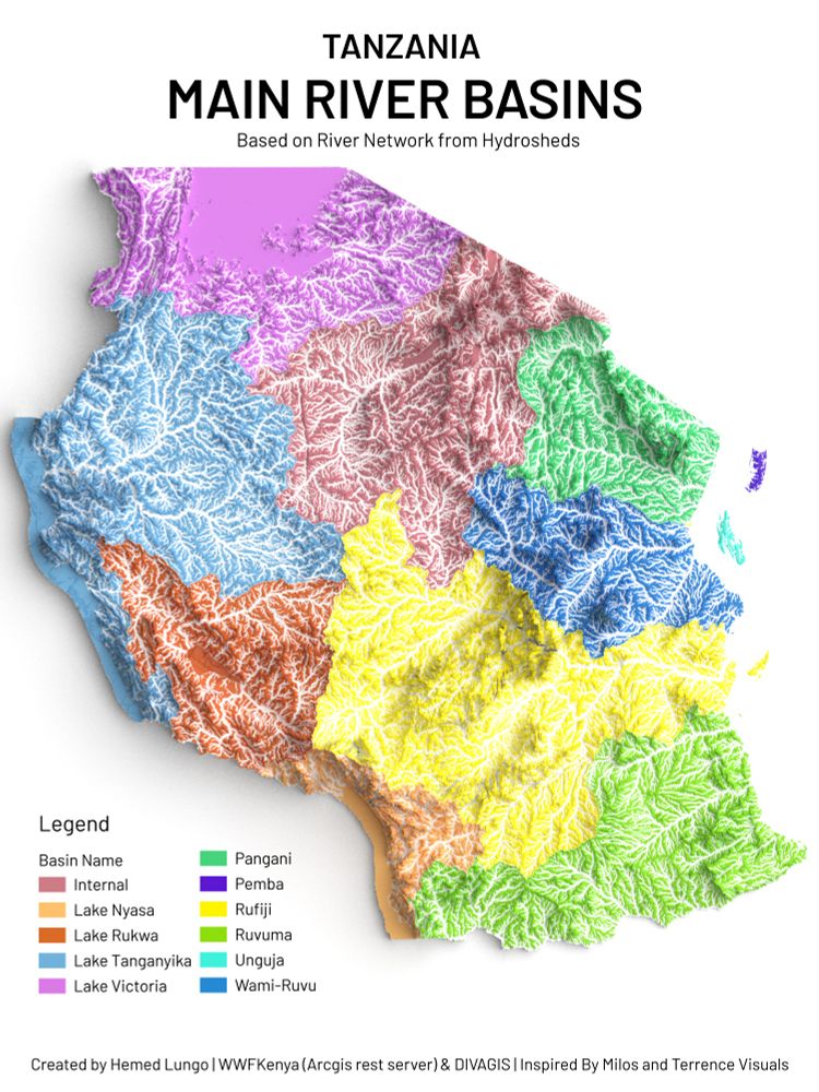
🗺️Tanzania River Basins 🇹🇿
Made with QGIS & Blender using:
(💧 HydroSHEDS,WWF 🏔️ DEM from DivaGIS)
A detailed look at Tanzania’s waterways from Lake Victoria & Tanganyika to Rufiji, Pangani, Ruvuma, and island basins of Unguja & Pemba.
#Tanzania #Africa #QGIS #Blender #gischat
Tanzania River Basin
725hemeed.bsky.social
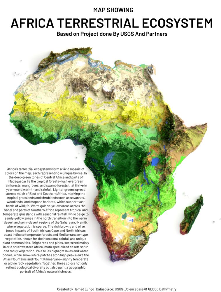
A Map🗺️ Showing Terrestrial Ecosystem of Africa Continent , Dataset is from USGS (ScienceBase) #Africa #EastAfrica #WestAfrica #SouthAfrica #NorthAfrica #Soil #Soiltype #geology #map #dataviz #gischat #geospatial #dataviz #qgis #b3d #Blender #USGS
Terrestrial Ecosystem of Africa
725hemeed.bsky.social
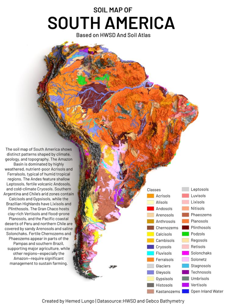
A Map🗺️Showing Soil Types of South America Continent , Dataset is from HWSD and GEBCO Bathymetry #SouthAmerica #LatinAmerica #Soil #Soiltype #geology #map #dataviz #gischat #geospatial #dataviz #qgis #b3d #Blender
Soil Types of South America Continent
725hemeed.bsky.social
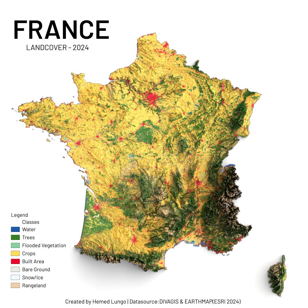
🗺️ France Landcover – 2024 🇫🇷
Réalisée avec QGIS & Blender à l’aide de :
🌱 ESRI Land Cover (2024)
🏔️ DEM de DivaGIS
Un aperçu éclatant des paysages français : forêts, cultures, montagnes, rivières et zones urbaines en expansion.
#France #Europe #QGIS #Blender #data #gischat #map
France Landcover – 2024
725hemeed.bsky.social
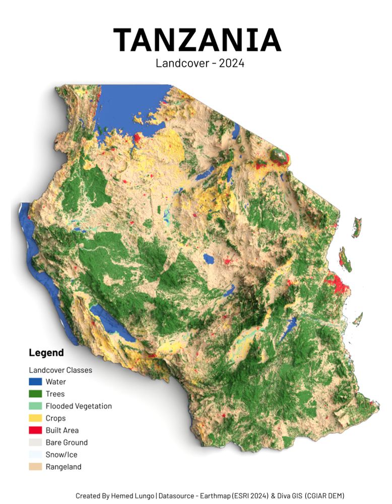
🗺️Tanzania Landcover – 2024🇹🇿
Made with QGIS & Blender using:
🌱 ESRI Land Cover Data (2024)
🏔️ DEM from DivaGIS
A vivid look at Tanzania’s diverse landscapes: from lush forests and croplands to shimmering lakes and growing urban zones. #Tanzania #Africa #QGIS #Blender #gischat
🗺️Tanzania Landcover – 2024🇹🇿
725hemeed.bsky.social
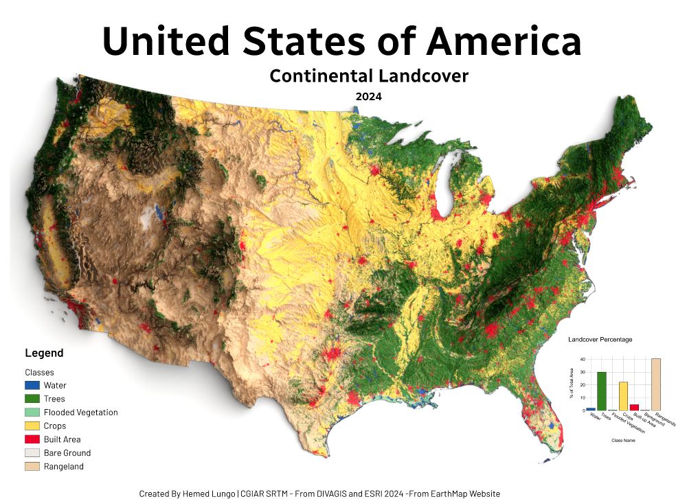
🗺️ USA Land Cover Map – 2024 🇺🇸
Made with QGIS & Blender using:
🌱 ESRI Land Cover (EarthMap)
🏔️ DEM from DivaGIS (CGIAR SRTM)
Forests, croplands, wetlands & cities — mapped to show the patterns shaping America's surface.
#USA #LandCover #QGIS #Blender #Cartography #GISChat #RemoteSensing #Map #OpenData
Landcover Map of U.S.A 2024
725hemeed.bsky.social
Thank you Hugh 😄🙏
725hemeed.bsky.social
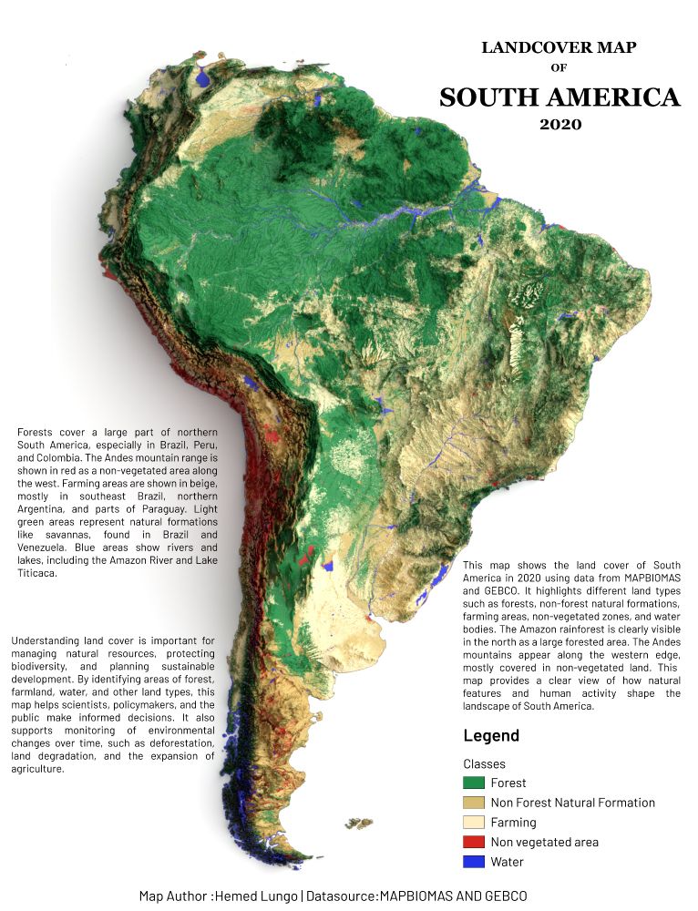
🗺️ Map showing Land Cover of South America (2020)
From the vast Amazon 🌳 to the Andes 🏔️ and farmlands 🌾 — this map reveals how land is used across the continent.

📊 Data:
@mapbiomas
@gebcobathymetry

#GIS #GEBCO #QGIS #Blender #gischat #Cartography #OpenData #SouthAmerica
Map showing Landcover of South America
725hemeed.bsky.social
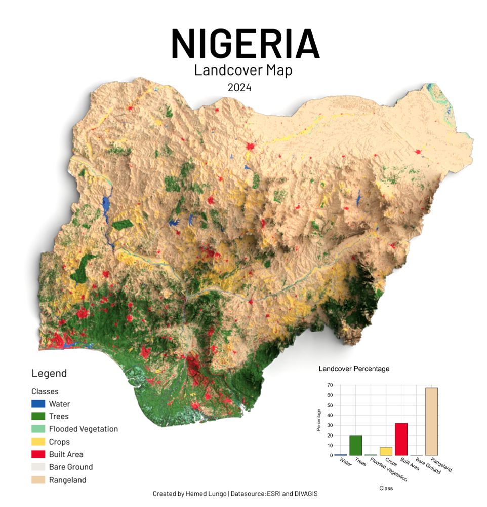
🗺️ Map showing Nigeria Land Cover – 2024 🇳🇬
Made with QGIS & Blender using:
🌱 ESRI Land Cover Data
🏔️ DEM from DivaGIS
Visualizing Nigeria’s diverse landscapes — forests, farmlands, water bodies & urban zones.
#Nigeria #Africa #QGIS #Blender #Cartography #gischat #LandCover #Map
Map showing Landcover of Nigeria
Reposted by Hemed
aasmith.bsky.social
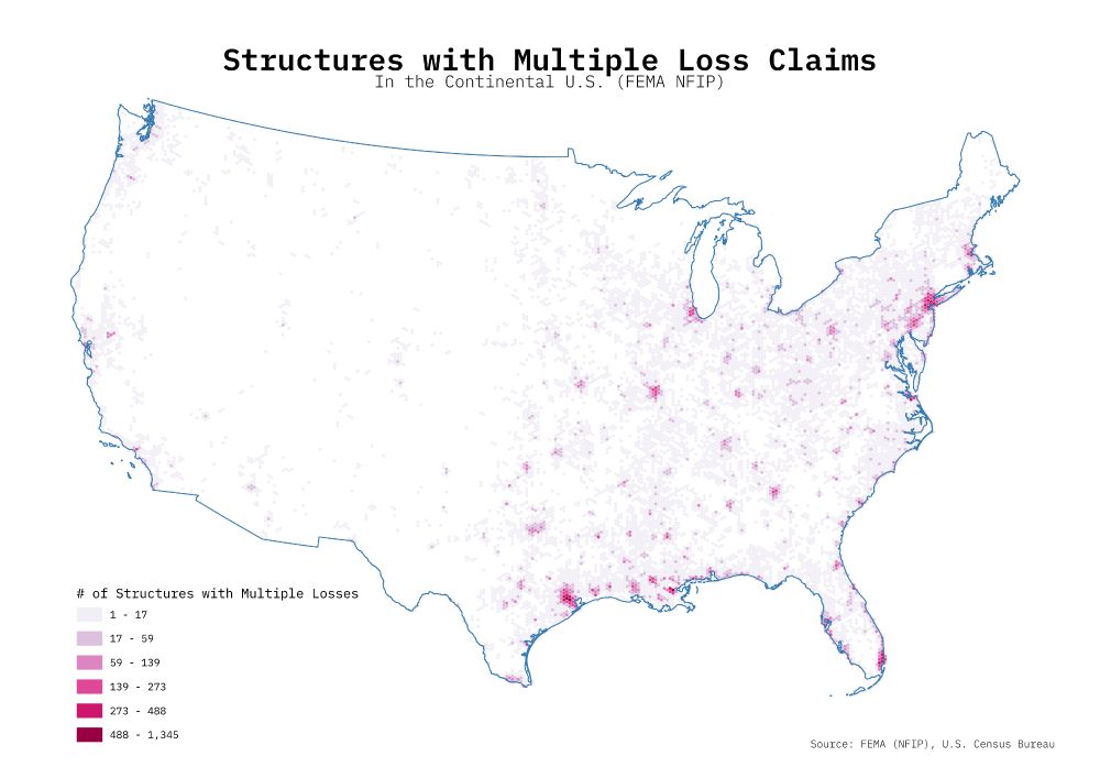
Inspired by @imagineterrain.bsky.social recent maps using the FEMA NFIP dataset, I decided to make a map of my own. After hex binning the data, the spatial pattern more or less follows population centers, at least for the eastern portion of the US.

I am still learning #QGIS!

#GISChat #GIS
A hex-binned choropleth map showing the number of structures in the continental US with multiple loss claims.
Reposted by Hemed
underdarkgis.fosstodon.org.ap.brid.gy
There's some great explanation for how map projections work in this short, but it's too hot today for me to work it out 😅

https://youtube.com/shorts/hrGJIk7zpho?si=xITVIzbJhaNr_qNS

#gischat
Reposted by Hemed
R and QGIS, name a better combo

#databs
smachlis.bsky.social
“I used R the statistical programming language to analyse each of the 3-hourly netCDFs — a file format for storing multidimensional scientific data — and create a geoJSON file where the data was greater than 35C. These files were then loaded into Qgis and styled….” - @sdbernard.bsky.social #RStats
Reposted by Hemed
uk.osgeo.org
Alasdair Rae is the Head of Data and Spatial Analysis at Lanpro. Founder of Automatic Knowledge Ltd - geographic data analyst, also Head of Data at Custodian Golf, QGIS trainer and all round geospatial guy.
Reposted by Hemed
qwast-gis.com
🎙Last Saturday, I had a great chat with Safae Aala on the To Open Doors I.Talk #podcast about my 25-year GIS journey. We covered #QGIS, #opensource, #education & #innovation.  
📺 Check it out here: youtu.be/_qhJezrsK-o

#gischat
𝐄𝐧𝐠| I.Talk 31🎙 : 25 Years of GIS|QGIS, innovation & Impact | The Journey of @HansvanderKwast
YouTube video by To Open Doors
youtu.be