


A Winter Weather Advisory starts tonight for the area, with 3–5 inches expected in the Denver metro area and Palmer Divide; heavier snow is possible in the foothills and higher elevations. The snowiest day on record for this date is 4.5 inches (1932).
www.anecast.ai/for/denver-c... #cowx
www.anecast.ai/for/denver-c... #cowx
www.anecast.ai
December 3, 2025 at 1:37 AM
A Winter Weather Advisory starts tonight for the area, with 3–5 inches expected in the Denver metro area and Palmer Divide; heavier snow is possible in the foothills and higher elevations. The snowiest day on record for this date is 4.5 inches (1932).
www.anecast.ai/for/denver-c... #cowx
www.anecast.ai/for/denver-c... #cowx
This week in Denver, mountain showers Thu–Fri could bring 1–4 inches on Palmer Divide; some ensembles hint at wintry weather reaching lower elevations by Sun–Mon.
www.anecast.ai/for/denver-c...
www.anecast.ai/for/denver-c...
www.anecast.ai
October 22, 2025 at 1:31 AM
This week in Denver, mountain showers Thu–Fri could bring 1–4 inches on Palmer Divide; some ensembles hint at wintry weather reaching lower elevations by Sun–Mon.
www.anecast.ai/for/denver-c...
www.anecast.ai/for/denver-c...
Reposted

A spectacular "cold wake" is evident along former-hurricane Erin's track. This is a normal feature caused by strong winds upwelling/mixing cooler water from below. Erin was not only very intense but also very large, which also helps with the upwelling. The water temperatures will gradually recover.
August 26, 2025 at 12:32 PM
A spectacular "cold wake" is evident along former-hurricane Erin's track. This is a normal feature caused by strong winds upwelling/mixing cooler water from below. Erin was not only very intense but also very large, which also helps with the upwelling. The water temperatures will gradually recover.
A weak surface low is forecast to raise shower and storm chances late Thursday into Friday, with the greatest odds along the Charleston coast — plan for a potentially wetter commute then.
www.anecast.ai/for/charlest... #charleston #scwx
www.anecast.ai/for/charlest... #charleston #scwx
www.anecast.ai
August 26, 2025 at 11:12 AM
A weak surface low is forecast to raise shower and storm chances late Thursday into Friday, with the greatest odds along the Charleston coast — plan for a potentially wetter commute then.
www.anecast.ai/for/charlest... #charleston #scwx
www.anecast.ai/for/charlest... #charleston #scwx
Today's high around 82°F will sit several degrees below the average high of 87.6°F for this date (records since 1930), with northwest gusts to ~20 mph keeping conditions drier and breezier than usual.
www.anecast.ai/for/atlanta-... #atlanta #gawx
www.anecast.ai/for/atlanta-... #atlanta #gawx
www.anecast.ai
August 26, 2025 at 11:06 AM
Today's high around 82°F will sit several degrees below the average high of 87.6°F for this date (records since 1930), with northwest gusts to ~20 mph keeping conditions drier and breezier than usual.
www.anecast.ai/for/atlanta-... #atlanta #gawx
www.anecast.ai/for/atlanta-... #atlanta #gawx
Today's high is forecast near 78°F — about 8°F cooler than the average high of 85.7°F (records since 1921); the record high for the date is 97°F.
www.anecast.ai/for/denver-c... #cowx
www.anecast.ai/for/denver-c... #cowx
www.anecast.ai
August 26, 2025 at 11:04 AM
Today's high is forecast near 78°F — about 8°F cooler than the average high of 85.7°F (records since 1921); the record high for the date is 97°F.
www.anecast.ai/for/denver-c... #cowx
www.anecast.ai/for/denver-c... #cowx
Reposted
The 2001 image was featured as a "Picture of Month" in the Monthly Weather Review:
journals.ametsoc.org/view/journal...
[2/2]
journals.ametsoc.org/view/journal...
[2/2]

August 22, 2025 at 12:53 PM
The 2001 image was featured as a "Picture of Month" in the Monthly Weather Review:
journals.ametsoc.org/view/journal...
[2/2]
journals.ametsoc.org/view/journal...
[2/2]
Reposted
One of only four Category 5 hurricane landfalls in the U.S. since records began in 1851-- the center of tiny-but-powerful Andrew hit a few miles south of Miami around 5am on August 24, 1992.
Lots more at bmcnoldy.earth.miami.edu/tropics/andr...
Lots more at bmcnoldy.earth.miami.edu/tropics/andr...
August 24, 2025 at 12:03 PM
One of only four Category 5 hurricane landfalls in the U.S. since records began in 1851-- the center of tiny-but-powerful Andrew hit a few miles south of Miami around 5am on August 24, 1992.
Lots more at bmcnoldy.earth.miami.edu/tropics/andr...
Lots more at bmcnoldy.earth.miami.edu/tropics/andr...
This morning’s fog in Philadelphia will slow early commutes—expect low visibility through the early hours, but it should thin by late morning as temperatures rise into the mid‑60s.
www.anecast.ai/for/philadel...
www.anecast.ai/for/philadel...
www.anecast.ai
August 21, 2025 at 10:26 AM
This morning’s fog in Philadelphia will slow early commutes—expect low visibility through the early hours, but it should thin by late morning as temperatures rise into the mid‑60s.
www.anecast.ai/for/philadel...
www.anecast.ai/for/philadel...
Morning will be noticeably cool for Richmond — highs only around 76°F, well under the typical 85.9°F for this date (records since 1939).
www.anecast.ai/for/richmond... #vawx
www.anecast.ai/for/richmond... #vawx
www.anecast.ai
August 21, 2025 at 10:23 AM
Morning will be noticeably cool for Richmond — highs only around 76°F, well under the typical 85.9°F for this date (records since 1939).
www.anecast.ai/for/richmond... #vawx
www.anecast.ai/for/richmond... #vawx
Today's high near 89°F is a touch above the August 21 average high of 87.4°F — well short of the 100.9°F record for the date, but worth noting (records since 1930).
www.anecast.ai/for/atlanta-... #gawx
www.anecast.ai/for/atlanta-... #gawx
www.anecast.ai
August 21, 2025 at 10:22 AM
Today's high near 89°F is a touch above the August 21 average high of 87.4°F — well short of the 100.9°F record for the date, but worth noting (records since 1930).
www.anecast.ai/for/atlanta-... #gawx
www.anecast.ai/for/atlanta-... #gawx
Reposted

SCOOP: Trump administration slashes scope of next-generation US weather satellites, eliminating air quality and ocean observing sensors. (1/3)
August 20, 2025 at 7:37 PM
SCOOP: Trump administration slashes scope of next-generation US weather satellites, eliminating air quality and ocean observing sensors. (1/3)
Reposted

Look at all that blue! A big shot of pleasant, fall-like air looms next week. 😍 🥂
Could end up with a string of days in the 70s and little to no humidity. Details and forecast update at cwg.live.
Could end up with a string of days in the 70s and little to no humidity. Details and forecast update at cwg.live.

August 20, 2025 at 8:43 PM
Look at all that blue! A big shot of pleasant, fall-like air looms next week. 😍 🥂
Could end up with a string of days in the 70s and little to no humidity. Details and forecast update at cwg.live.
Could end up with a string of days in the 70s and little to no humidity. Details and forecast update at cwg.live.
Reposted

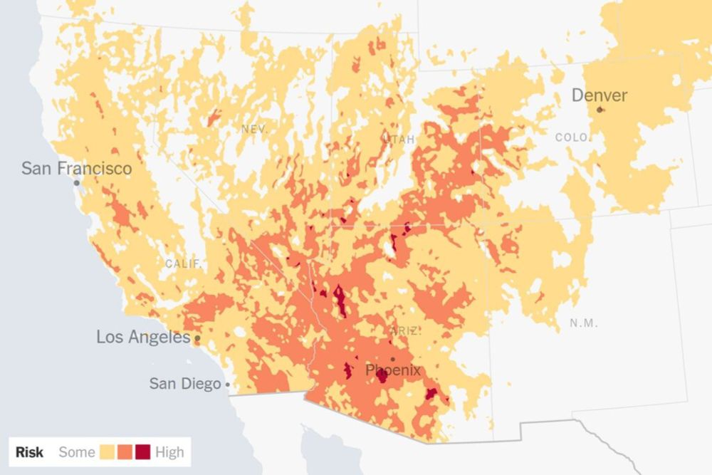
A heat wave building in Southern California is expected to peak Thursday through Saturday, breaking a run of unseasonably mild summer weather and creating a prime environment for wildfires to spread rapidly. www.nytimes.com/2025/08/20/w...
A Combustible Mix of Heat and Storms Is Expected Across Southern California
www.nytimes.com
August 20, 2025 at 9:50 PM
A heat wave building in Southern California is expected to peak Thursday through Saturday, breaking a run of unseasonably mild summer weather and creating a prime environment for wildfires to spread rapidly. www.nytimes.com/2025/08/20/w...


A pattern shift begins Friday — expect cooler, wetter conditions with scattered to potentially heavy storms through the weekend and Monday; keep weekend outdoor plans flexible and watch for localized heavy downpours in Denver.
www.anecast.ai/for/denver-c... #cowx
www.anecast.ai/for/denver-c... #cowx
www.anecast.ai
August 20, 2025 at 9:25 PM
A pattern shift begins Friday — expect cooler, wetter conditions with scattered to potentially heavy storms through the weekend and Monday; keep weekend outdoor plans flexible and watch for localized heavy downpours in Denver.
www.anecast.ai/for/denver-c... #cowx
www.anecast.ai/for/denver-c... #cowx
With Hurricane Erin well offshore, Wilmington beaches will see large swells and a high rip‑current risk through Friday—avoid swimming today and watch for minor coastal flooding/overwash around high tides late afternoon and evening.
www.anecast.ai/for/wilmingt... #ncwx #erin
www.anecast.ai/for/wilmingt... #ncwx #erin
www.anecast.ai
August 20, 2025 at 10:48 AM
With Hurricane Erin well offshore, Wilmington beaches will see large swells and a high rip‑current risk through Friday—avoid swimming today and watch for minor coastal flooding/overwash around high tides late afternoon and evening.
www.anecast.ai/for/wilmingt... #ncwx #erin
www.anecast.ai/for/wilmingt... #ncwx #erin
Hurricane Erin offshore is still pumping 5–13 ft swell and 25–30 kt gusts — expect very high surf and a high risk of dangerous rip currents off Tybee Island today; avoid entering the water even if it looks calm from shore.
www.anecast.ai/for/tybee-is... #tybee #gawx
www.anecast.ai/for/tybee-is... #tybee #gawx
www.anecast.ai
August 20, 2025 at 10:07 AM
Hurricane Erin offshore is still pumping 5–13 ft swell and 25–30 kt gusts — expect very high surf and a high risk of dangerous rip currents off Tybee Island today; avoid entering the water even if it looks calm from shore.
www.anecast.ai/for/tybee-is... #tybee #gawx
www.anecast.ai/for/tybee-is... #tybee #gawx
Hurricane Erin will pass offshore Wed night–Thu; expect very large long‑period swell (seas 15–25 ft) and N/NE winds 30–40 kt with gusts to 50 kt — life‑threatening rip currents, coastal flooding/overwash, and major beach erosion are likely, especia…
www.anecast.ai/for/outer-ba... #outerbanks #erin
www.anecast.ai/for/outer-ba... #outerbanks #erin
www.anecast.ai
August 20, 2025 at 1:22 AM
Hurricane Erin will pass offshore Wed night–Thu; expect very large long‑period swell (seas 15–25 ft) and N/NE winds 30–40 kt with gusts to 50 kt — life‑threatening rip currents, coastal flooding/overwash, and major beach erosion are likely, especia…
www.anecast.ai/for/outer-ba... #outerbanks #erin
www.anecast.ai/for/outer-ba... #outerbanks #erin
Reposted

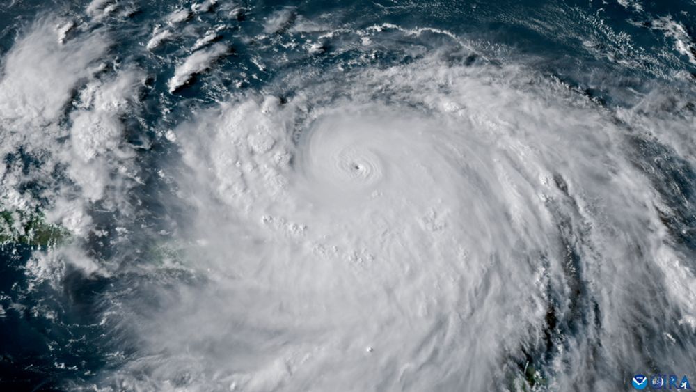
Stunning imagery of lightning within Hurricane Erin.
Erin remains a powerful, major hurricane.
Erin remains a powerful, major hurricane.
August 16, 2025 at 11:57 PM
Stunning imagery of lightning within Hurricane Erin.
Erin remains a powerful, major hurricane.
Erin remains a powerful, major hurricane.
Reposted

Unbelievable footage from NOAA’s Hurricane Hunters inside the eye of Hurricane Erin.
Simply incredible.
Simply incredible.
August 16, 2025 at 9:22 PM
Unbelievable footage from NOAA’s Hurricane Hunters inside the eye of Hurricane Erin.
Simply incredible.
Simply incredible.
Reposted

Hurricane Erin.
Simply breathtaking.
Simply breathtaking.
August 17, 2025 at 1:54 AM
Hurricane Erin.
Simply breathtaking.
Simply breathtaking.
Boaters and shoreline visitors beware: very long swells and 7–15 ft seas (largest north of Cape Fear) could cause minor coastal flooding and beach erosion around high tides midweek. #Erin #scwx www.anecast.ai/for/myrtle-b...
www.anecast.ai
August 19, 2025 at 7:03 PM
Boaters and shoreline visitors beware: very long swells and 7–15 ft seas (largest north of Cape Fear) could cause minor coastal flooding and beach erosion around high tides midweek. #Erin #scwx www.anecast.ai/for/myrtle-b...
Hurricane #Erin, about 500 miles offshore, will crank up high surf and dangerous rip currents at Tybee Island—stay out of the surf and follow beach warnings this week. #gawx #Savannah www.anecast.ai/for/tybee-is...
www.anecast.ai
August 19, 2025 at 7:02 PM
Hurricane #Erin, about 500 miles offshore, will crank up high surf and dangerous rip currents at Tybee Island—stay out of the surf and follow beach warnings this week. #gawx #Savannah www.anecast.ai/for/tybee-is...