


Brad Storm Chaser
@bradstorm19.bsky.social
I love weather and storms.
Reposted by Brad Storm Chaser

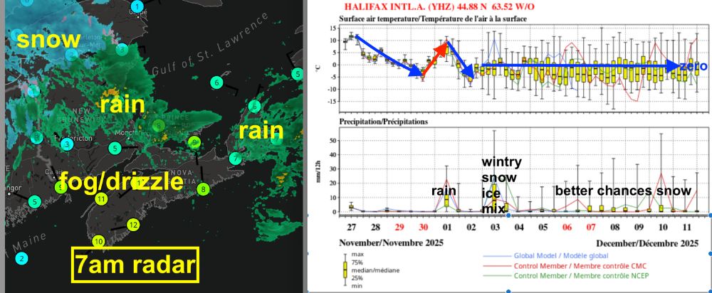
The messy storm has heaviest snow (20+cm) over high ground inland NS; heavy rain along the coast. Strong NE winds: over 20K outages at 7am.
The wind & precip mix tapers off this am (aftn CB) then clearing.
Thurs starts fine then rain changes to snow. Strong NW winds & turning COLD & icy!.
The wind & precip mix tapers off this am (aftn CB) then clearing.
Thurs starts fine then rain changes to snow. Strong NW winds & turning COLD & icy!.

December 3, 2025 at 11:01 AM
The messy storm has heaviest snow (20+cm) over high ground inland NS; heavy rain along the coast. Strong NE winds: over 20K outages at 7am.
The wind & precip mix tapers off this am (aftn CB) then clearing.
Thurs starts fine then rain changes to snow. Strong NW winds & turning COLD & icy!.
The wind & precip mix tapers off this am (aftn CB) then clearing.
Thurs starts fine then rain changes to snow. Strong NW winds & turning COLD & icy!.
Reposted by Brad Storm Chaser
5pm update: snow spreading across the Maritimes. Heaviest snow now in Annapolis Valley. Rain right along the Atlantic coast... the line right thru Halifax.
No surprises... yet :-)
No surprises... yet :-)

December 2, 2025 at 9:18 PM
5pm update: snow spreading across the Maritimes. Heaviest snow now in Annapolis Valley. Rain right along the Atlantic coast... the line right thru Halifax.
No surprises... yet :-)
No surprises... yet :-)
Reposted by Brad Storm Chaser

A messy mix of snow and rain moves through the Maritimes tonight, clearing through Wednesday. Meantime, heavy snow for much of Newfoundland but some mixing in the southeast. Full update: facebook.com/story.php?st... #NSwx #NBwx #PEwx #NLwx


December 2, 2025 at 9:00 PM
A messy mix of snow and rain moves through the Maritimes tonight, clearing through Wednesday. Meantime, heavy snow for much of Newfoundland but some mixing in the southeast. Full update: facebook.com/story.php?st... #NSwx #NBwx #PEwx #NLwx
Reposted by Brad Storm Chaser
Winter storm: snow begins in the west this aftn (4pm HFX).
Snow mixed with rain/ice along coasts. Heaviest snow inland/high ground NS & parts Kings PEI (15-30+cm). See pics for pattern; still uncertainty. Strong NE winds (outage risk).
Improves Wed aftn. A brief system Thurs night: icy roads.
Ugh.
Snow mixed with rain/ice along coasts. Heaviest snow inland/high ground NS & parts Kings PEI (15-30+cm). See pics for pattern; still uncertainty. Strong NE winds (outage risk).
Improves Wed aftn. A brief system Thurs night: icy roads.
Ugh.

December 2, 2025 at 11:24 AM
Winter storm: snow begins in the west this aftn (4pm HFX).
Snow mixed with rain/ice along coasts. Heaviest snow inland/high ground NS & parts Kings PEI (15-30+cm). See pics for pattern; still uncertainty. Strong NE winds (outage risk).
Improves Wed aftn. A brief system Thurs night: icy roads.
Ugh.
Snow mixed with rain/ice along coasts. Heaviest snow inland/high ground NS & parts Kings PEI (15-30+cm). See pics for pattern; still uncertainty. Strong NE winds (outage risk).
Improves Wed aftn. A brief system Thurs night: icy roads.
Ugh.
Reposted by Brad Storm Chaser

Incoming Nor'easter will bring a messy mix of heavy snow, rain and strong northeast winds.
Impacts include tricky travel conditions & the potential for power outages.
The latest on the totals & timeline:
NS: www.cbc.ca/news/canada/...
NB: www.cbc.ca/player/play/...
#nsstorm #nbstorm #halisky
Impacts include tricky travel conditions & the potential for power outages.
The latest on the totals & timeline:
NS: www.cbc.ca/news/canada/...
NB: www.cbc.ca/player/play/...
#nsstorm #nbstorm #halisky


December 1, 2025 at 10:44 PM
Incoming Nor'easter will bring a messy mix of heavy snow, rain and strong northeast winds.
Impacts include tricky travel conditions & the potential for power outages.
The latest on the totals & timeline:
NS: www.cbc.ca/news/canada/...
NB: www.cbc.ca/player/play/...
#nsstorm #nbstorm #halisky
Impacts include tricky travel conditions & the potential for power outages.
The latest on the totals & timeline:
NS: www.cbc.ca/news/canada/...
NB: www.cbc.ca/player/play/...
#nsstorm #nbstorm #halisky
Reposted by Brad Storm Chaser
A nor’easter will bring a messy mix of snow and rain to the Maritimes Tuesday afternoon and night, clearing through Wednesday. The storm also impacts Newfoundland into and on Wednesday. Full detailed update here: facebook.com/story.php?st...
#NSwx #NBwx #PEwx #NLwx
#NSwx #NBwx #PEwx #NLwx


December 1, 2025 at 10:04 PM
A nor’easter will bring a messy mix of snow and rain to the Maritimes Tuesday afternoon and night, clearing through Wednesday. The storm also impacts Newfoundland into and on Wednesday. Full detailed update here: facebook.com/story.php?st...
#NSwx #NBwx #PEwx #NLwx
#NSwx #NBwx #PEwx #NLwx
Reposted by Brad Storm Chaser
There are some consistencies in snowfall forecasts for late Tuesday thru Wednesday:
- the Atlantic coast most likely to have a rain mix; so lower snowfalls
- high ground over the South Mountain (Ann Valley) & N NS most likely to have higher snowfalls.
- wet snow not as deep, but is heavy!
Still TBD
- the Atlantic coast most likely to have a rain mix; so lower snowfalls
- high ground over the South Mountain (Ann Valley) & N NS most likely to have higher snowfalls.
- wet snow not as deep, but is heavy!
Still TBD

December 1, 2025 at 6:46 PM
There are some consistencies in snowfall forecasts for late Tuesday thru Wednesday:
- the Atlantic coast most likely to have a rain mix; so lower snowfalls
- high ground over the South Mountain (Ann Valley) & N NS most likely to have higher snowfalls.
- wet snow not as deep, but is heavy!
Still TBD
- the Atlantic coast most likely to have a rain mix; so lower snowfalls
- high ground over the South Mountain (Ann Valley) & N NS most likely to have higher snowfalls.
- wet snow not as deep, but is heavy!
Still TBD
Reposted by Brad Storm Chaser
The back edge of the band of rain is nearing Moncton-Halifax at 7:30am, moves past CB this aftn. Just a few showers or flurries afterwards.
Snow from a developing storm spreads into western Maritimes Tuesday aftn then further east Tuesday night. Wednesday morning will be messy with stron NE winds.
Snow from a developing storm spreads into western Maritimes Tuesday aftn then further east Tuesday night. Wednesday morning will be messy with stron NE winds.

December 1, 2025 at 11:26 AM
The back edge of the band of rain is nearing Moncton-Halifax at 7:30am, moves past CB this aftn. Just a few showers or flurries afterwards.
Snow from a developing storm spreads into western Maritimes Tuesday aftn then further east Tuesday night. Wednesday morning will be messy with stron NE winds.
Snow from a developing storm spreads into western Maritimes Tuesday aftn then further east Tuesday night. Wednesday morning will be messy with stron NE winds.
Reposted by Brad Storm Chaser
Fine start to Sunday. Snow moves into NB this aftn changing to rain in south this eve. Rain overnight (5-10mm) in all three provinces; tapers to showers/drizzle Monday (not til eve CB).
Fine Tues then winter storm Tues night-Wed: no consensus on precip type/amounts. Stay tuned.
Fine Tues then winter storm Tues night-Wed: no consensus on precip type/amounts. Stay tuned.

November 30, 2025 at 11:47 AM
Fine start to Sunday. Snow moves into NB this aftn changing to rain in south this eve. Rain overnight (5-10mm) in all three provinces; tapers to showers/drizzle Monday (not til eve CB).
Fine Tues then winter storm Tues night-Wed: no consensus on precip type/amounts. Stay tuned.
Fine Tues then winter storm Tues night-Wed: no consensus on precip type/amounts. Stay tuned.
Reposted by Brad Storm Chaser
A chilly brisk west wind generating onshore light snow off Bay of Fundy & Gulf. A few flurries reaching YHZ & Sydney. Otherwise sun-cloud mix. Snow spreads across NB Sunday aftn the changes to rain over the region Sunday night into Monday.
Snowstorm risk Wed: heaviest NS in from ATL coast & E PEI?
Snowstorm risk Wed: heaviest NS in from ATL coast & E PEI?

November 29, 2025 at 11:45 AM
A chilly brisk west wind generating onshore light snow off Bay of Fundy & Gulf. A few flurries reaching YHZ & Sydney. Otherwise sun-cloud mix. Snow spreads across NB Sunday aftn the changes to rain over the region Sunday night into Monday.
Snowstorm risk Wed: heaviest NS in from ATL coast & E PEI?
Snowstorm risk Wed: heaviest NS in from ATL coast & E PEI?
Reposted by Brad Storm Chaser
Onshore flurries and snow off west-facing coasts to start the weekend. Our next low tracks to the north Sunday night - Monday with rain for most, but some mixing/snow. All eyes then on Tuesday-Wednesday. Full update: facebook.com/story.php?st... #NSwx #NBwx #PEwx #NLwx


November 28, 2025 at 10:29 PM
Onshore flurries and snow off west-facing coasts to start the weekend. Our next low tracks to the north Sunday night - Monday with rain for most, but some mixing/snow. All eyes then on Tuesday-Wednesday. Full update: facebook.com/story.php?st... #NSwx #NBwx #PEwx #NLwx
Reposted by Brad Storm Chaser
Showers develop this afternoon; esply SW & E NS.
A cooler west wind Saturday with some onshore wet snow. Sun-cloud mix elsewhere.
Fine Sunday then snow moves into NB. Rain Sunday night ending Monday.
Tuesday night-Wednesday: possible snowstorm. Stay tuned.
A cooler west wind Saturday with some onshore wet snow. Sun-cloud mix elsewhere.
Fine Sunday then snow moves into NB. Rain Sunday night ending Monday.
Tuesday night-Wednesday: possible snowstorm. Stay tuned.

November 28, 2025 at 11:41 AM
Showers develop this afternoon; esply SW & E NS.
A cooler west wind Saturday with some onshore wet snow. Sun-cloud mix elsewhere.
Fine Sunday then snow moves into NB. Rain Sunday night ending Monday.
Tuesday night-Wednesday: possible snowstorm. Stay tuned.
A cooler west wind Saturday with some onshore wet snow. Sun-cloud mix elsewhere.
Fine Sunday then snow moves into NB. Rain Sunday night ending Monday.
Tuesday night-Wednesday: possible snowstorm. Stay tuned.
Reposted by Brad Storm Chaser
Chance of showers & flurries for Friday.
Cool & quiet weekend.
Next system late Sunday/Monday brings mostly rain & some mixing for NB.
Lots of buzz about a snowstorm next week. Still early, but potential is there.
More here:
NS: www.youtube.com/watch?v=i9D3...
NB: www.cbc.ca/player/play/...
Cool & quiet weekend.
Next system late Sunday/Monday brings mostly rain & some mixing for NB.
Lots of buzz about a snowstorm next week. Still early, but potential is there.
More here:
NS: www.youtube.com/watch?v=i9D3...
NB: www.cbc.ca/player/play/...

November 27, 2025 at 10:41 PM
Chance of showers & flurries for Friday.
Cool & quiet weekend.
Next system late Sunday/Monday brings mostly rain & some mixing for NB.
Lots of buzz about a snowstorm next week. Still early, but potential is there.
More here:
NS: www.youtube.com/watch?v=i9D3...
NB: www.cbc.ca/player/play/...
Cool & quiet weekend.
Next system late Sunday/Monday brings mostly rain & some mixing for NB.
Lots of buzz about a snowstorm next week. Still early, but potential is there.
More here:
NS: www.youtube.com/watch?v=i9D3...
NB: www.cbc.ca/player/play/...
Reposted by Brad Storm Chaser
Had 22.6mm of rain. Just fog & drizzle over the S&W half of the Maritimes which clears to a sun-cloud mix. The rain moves off the N&E with clearing not til later in day.
The multimodel outlook has cooling over next few days. A warm up with rain Sunday night; then turning colder & wintry next week?
The multimodel outlook has cooling over next few days. A warm up with rain Sunday night; then turning colder & wintry next week?
November 27, 2025 at 11:47 AM
Had 22.6mm of rain. Just fog & drizzle over the S&W half of the Maritimes which clears to a sun-cloud mix. The rain moves off the N&E with clearing not til later in day.
The multimodel outlook has cooling over next few days. A warm up with rain Sunday night; then turning colder & wintry next week?
The multimodel outlook has cooling over next few days. A warm up with rain Sunday night; then turning colder & wintry next week?
Reposted by Brad Storm Chaser
Rain nearing CB early this am with a wintry mix over N NB. Rain persists today then tapers to showers/drizzle tonight & Thurs am followed by clearing. 15-25mm rain (closer to 10mm Ann Valley); 5-10cm snow extreme N NB.
Fine start Fri then onshore rain/snow showers in gusty W winds late Fri & Sat.
Fine start Fri then onshore rain/snow showers in gusty W winds late Fri & Sat.

November 26, 2025 at 11:53 AM
Rain nearing CB early this am with a wintry mix over N NB. Rain persists today then tapers to showers/drizzle tonight & Thurs am followed by clearing. 15-25mm rain (closer to 10mm Ann Valley); 5-10cm snow extreme N NB.
Fine start Fri then onshore rain/snow showers in gusty W winds late Fri & Sat.
Fine start Fri then onshore rain/snow showers in gusty W winds late Fri & Sat.
Reposted by Brad Storm Chaser
Most of the clouds will be high, so a fairly bright fine day.
Rain spreads across the region Wednesday; starts as icy mix in parts of central-north NB. Rain tapers to drizzle/showers Thursday then clears.
Not bad Friday then a gusty NW wind and onshore rain-snow showers Saturday.
Rain again Monday.
Rain spreads across the region Wednesday; starts as icy mix in parts of central-north NB. Rain tapers to drizzle/showers Thursday then clears.
Not bad Friday then a gusty NW wind and onshore rain-snow showers Saturday.
Rain again Monday.

November 25, 2025 at 10:41 AM
Most of the clouds will be high, so a fairly bright fine day.
Rain spreads across the region Wednesday; starts as icy mix in parts of central-north NB. Rain tapers to drizzle/showers Thursday then clears.
Not bad Friday then a gusty NW wind and onshore rain-snow showers Saturday.
Rain again Monday.
Rain spreads across the region Wednesday; starts as icy mix in parts of central-north NB. Rain tapers to drizzle/showers Thursday then clears.
Not bad Friday then a gusty NW wind and onshore rain-snow showers Saturday.
Rain again Monday.
Reposted by Brad Storm Chaser


Reposted by Brad Storm Chaser
Just patchy light precip mix today; more likely over NS (watch for slippery spots this am). Skies clear first in NB then elsewhere for a fine Tuesday.
Rain spreads across the region Wednesday; tapering to showers Thursday.
A colder gusty west wind Friday & Saturday with onshore rain/snow showers.
Rain spreads across the region Wednesday; tapering to showers Thursday.
A colder gusty west wind Friday & Saturday with onshore rain/snow showers.

November 24, 2025 at 10:58 AM
Just patchy light precip mix today; more likely over NS (watch for slippery spots this am). Skies clear first in NB then elsewhere for a fine Tuesday.
Rain spreads across the region Wednesday; tapering to showers Thursday.
A colder gusty west wind Friday & Saturday with onshore rain/snow showers.
Rain spreads across the region Wednesday; tapering to showers Thursday.
A colder gusty west wind Friday & Saturday with onshore rain/snow showers.
Reposted by Brad Storm Chaser
Quite a bit of sun today in a coolish westerly breeze. More cloud CB with light snow in Highlands.
Risk black ice highest in Mainland NS Monday morning in light mixed precip. Clouds break up for fine afternoon.
Wednesday's system mostly rain then showery Thursday.
Chilly & gusty NW winds Fri-Sat.
Risk black ice highest in Mainland NS Monday morning in light mixed precip. Clouds break up for fine afternoon.
Wednesday's system mostly rain then showery Thursday.
Chilly & gusty NW winds Fri-Sat.

November 23, 2025 at 11:43 AM
Quite a bit of sun today in a coolish westerly breeze. More cloud CB with light snow in Highlands.
Risk black ice highest in Mainland NS Monday morning in light mixed precip. Clouds break up for fine afternoon.
Wednesday's system mostly rain then showery Thursday.
Chilly & gusty NW winds Fri-Sat.
Risk black ice highest in Mainland NS Monday morning in light mixed precip. Clouds break up for fine afternoon.
Wednesday's system mostly rain then showery Thursday.
Chilly & gusty NW winds Fri-Sat.
Reposted by Brad Storm Chaser
A relatively mild day; southwest NS might get close to 10C.
A band of rain clips the Atlantic coast later today; a sun-cloud mix further north.
Skies clear to sun-cloud mix Sunday in a cooler westerly breeze.
The only organized precipitation next week looks to be Wednesday; mostly rain, a mix N NB.
A band of rain clips the Atlantic coast later today; a sun-cloud mix further north.
Skies clear to sun-cloud mix Sunday in a cooler westerly breeze.
The only organized precipitation next week looks to be Wednesday; mostly rain, a mix N NB.

November 22, 2025 at 12:01 PM
A relatively mild day; southwest NS might get close to 10C.
A band of rain clips the Atlantic coast later today; a sun-cloud mix further north.
Skies clear to sun-cloud mix Sunday in a cooler westerly breeze.
The only organized precipitation next week looks to be Wednesday; mostly rain, a mix N NB.
A band of rain clips the Atlantic coast later today; a sun-cloud mix further north.
Skies clear to sun-cloud mix Sunday in a cooler westerly breeze.
The only organized precipitation next week looks to be Wednesday; mostly rain, a mix N NB.
Reposted by Brad Storm Chaser
Fairly quiet period ahead: just late day patchy light snow over the NW & light rain E NS.
Scattered showers (flurries N) cross the Maritimes Saturday with another area of rain clipping E NS in the evening.
Fine Sunday; just clouds in a westerly onshore breeze.
Next week also looks manageable...
Scattered showers (flurries N) cross the Maritimes Saturday with another area of rain clipping E NS in the evening.
Fine Sunday; just clouds in a westerly onshore breeze.
Next week also looks manageable...

November 21, 2025 at 10:50 AM
Fairly quiet period ahead: just late day patchy light snow over the NW & light rain E NS.
Scattered showers (flurries N) cross the Maritimes Saturday with another area of rain clipping E NS in the evening.
Fine Sunday; just clouds in a westerly onshore breeze.
Next week also looks manageable...
Scattered showers (flurries N) cross the Maritimes Saturday with another area of rain clipping E NS in the evening.
Fine Sunday; just clouds in a westerly onshore breeze.
Next week also looks manageable...
Reposted by Brad Storm Chaser
Frosty start but a nice day ahead.
Fine for much of the region Friday; an aftn band of rain clips E NS, with light snow in the extreme northwest.
Just a few showers (flurries north) Saturday that turns to steady rain over E NS late day.
Skies clear Sunday with some onshore cloud in a west breeze.
Fine for much of the region Friday; an aftn band of rain clips E NS, with light snow in the extreme northwest.
Just a few showers (flurries north) Saturday that turns to steady rain over E NS late day.
Skies clear Sunday with some onshore cloud in a west breeze.

November 20, 2025 at 11:46 AM
Frosty start but a nice day ahead.
Fine for much of the region Friday; an aftn band of rain clips E NS, with light snow in the extreme northwest.
Just a few showers (flurries north) Saturday that turns to steady rain over E NS late day.
Skies clear Sunday with some onshore cloud in a west breeze.
Fine for much of the region Friday; an aftn band of rain clips E NS, with light snow in the extreme northwest.
Just a few showers (flurries north) Saturday that turns to steady rain over E NS late day.
Skies clear Sunday with some onshore cloud in a west breeze.


Reposted by Brad Storm Chaser
An EU model animation suggests mostly fine til late Friday. Then a few showers (flurries north) develop; changing to rain during the day Saturday over Nova Scotia and PEI.
Sunday (not shown) should be a nice day... expect that after this European trip, we'll be starting some Christmas decorating.
Sunday (not shown) should be a nice day... expect that after this European trip, we'll be starting some Christmas decorating.
November 19, 2025 at 7:32 AM
An EU model animation suggests mostly fine til late Friday. Then a few showers (flurries north) develop; changing to rain during the day Saturday over Nova Scotia and PEI.
Sunday (not shown) should be a nice day... expect that after this European trip, we'll be starting some Christmas decorating.
Sunday (not shown) should be a nice day... expect that after this European trip, we'll be starting some Christmas decorating.
Reposted by Brad Storm Chaser
More sunshine in the mix on Wednesday in the Maritimes with temperatures a bit warmer. A chance of showers and flurries will linger for Newfoundland, greatest on the southwest and west coasts. Wind gusts 20-40+ km/h in the Maritimes, 30-60 km/h in NL. #NSwx #NBwx #PEwx #NLwx


November 18, 2025 at 10:05 PM