


@debbietheduck.bsky.social
Reposted

The Tumbling Bay bathing place, on the Bulstake Stream just north of the Botley Road in West Oxford, has reopened. The wild swimming spot was closed in 2024 due to concerns over the condition of the old retaining wall, which has now been replaced.

December 15, 2025 at 1:05 PM
The Tumbling Bay bathing place, on the Bulstake Stream just north of the Botley Road in West Oxford, has reopened. The wild swimming spot was closed in 2024 due to concerns over the condition of the old retaining wall, which has now been replaced.
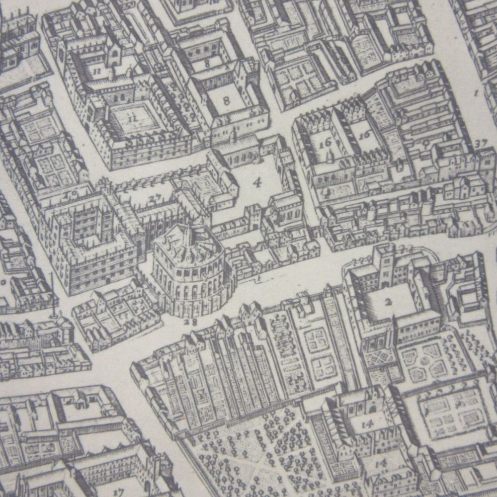
Thank you! Blog post now edited to remove reference to coal. There’s someone with what looks like a barrow of coal, but perhaps the engraver was using his imagination!
Very nice! But pretty sure they're not extracting coal, as the blog post says. Don't think we ever had that. It's most likely iron ore, or silver.
December 16, 2025 at 9:10 AM
Thank you! Blog post now edited to remove reference to coal. There’s someone with what looks like a barrow of coal, but perhaps the engraver was using his imagination!
Reposted
Bartomeu Olives 1575 portolan nautical chart of the Mediterranean includes a lovely elephant and the Red Sea (in red, obvs). Included is the parting of the sea created by God for Moses and the Israelites to cross, fleeing from the Egyptians, as stated in Exodus chapter 14. @bodleian.ox.ac.uk

October 7, 2025 at 11:28 AM
Bartomeu Olives 1575 portolan nautical chart of the Mediterranean includes a lovely elephant and the Red Sea (in red, obvs). Included is the parting of the sea created by God for Moses and the Israelites to cross, fleeing from the Egyptians, as stated in Exodus chapter 14. @bodleian.ox.ac.uk
Reposted
Another @bodleianlibraries.bsky.social #Maps blog takes us to C18 #London where @debbietheduck.bsky.social investigates improving catalogue records & unearths a printing mystery. Learn more about George Vertue's map at: blogs.bodleian.ox.ac.uk/maps/2025/01... @londonist.com @bcsmaps.bsky.social


January 15, 2025 at 2:01 PM
Another @bodleianlibraries.bsky.social #Maps blog takes us to C18 #London where @debbietheduck.bsky.social investigates improving catalogue records & unearths a printing mystery. Learn more about George Vertue's map at: blogs.bodleian.ox.ac.uk/maps/2025/01... @londonist.com @bcsmaps.bsky.social
Reposted
Feeling festive? @debbietheduck.bsky.social tells us about #reindeer in #maps from @bodleianlibraries.bsky.social. From #Lapland to #Birmingham, everything is covered here: blogs.bodleian.ox.ac.uk/maps/2024/12... Maps from C16 to this year & not a red nose in sight. Merry Christmas! @ox.ac.uk


December 18, 2024 at 3:13 PM
Feeling festive? @debbietheduck.bsky.social tells us about #reindeer in #maps from @bodleianlibraries.bsky.social. From #Lapland to #Birmingham, everything is covered here: blogs.bodleian.ox.ac.uk/maps/2024/12... Maps from C16 to this year & not a red nose in sight. Merry Christmas! @ox.ac.uk
Early example of wild swimming on a map cartouche from 1703 @outdoorswimmer.com
Wild swimming 1700s style, from a map of Denmark in the Atlas Contractus by Carel Allard, map by Frederick de Wit . Mercury, with winged helmet, God of messengers and travel, is in the corner while Neptune and a group of Putti, winged spirits, play in the water, 1703. @bodleianlibraries.bsky.social

December 13, 2024 at 11:17 AM
Early example of wild swimming on a map cartouche from 1703 @outdoorswimmer.com
Reposted
Another @bodleianlibraries.bsky.social blog from @stuartackland.bsky.social looks at a recent donation of #maps once belonging to John Alfred Spranger, a man with a passion for mountains. There is even a peak in #BritishColumbia named in his honour. Learn more at: blogs.bodleian.ox.ac.uk/maps/


December 5, 2024 at 3:12 PM
Another @bodleianlibraries.bsky.social blog from @stuartackland.bsky.social looks at a recent donation of #maps once belonging to John Alfred Spranger, a man with a passion for mountains. There is even a peak in #BritishColumbia named in his honour. Learn more at: blogs.bodleian.ox.ac.uk/maps/
Reposted
A #map with a great story. It arrived at @bodleianlibraries.bsky.social in Mar '78. Produced by #BlackSash in #SouthAfrica it mapped #homelands & forced migrations. Maps disguised as calendars were posted to libraries worldwide. 15 copies appear on #WorldCat. @ox.ac.uk @oxfordclarion.bsky.social


December 2, 2024 at 2:10 PM
A #map with a great story. It arrived at @bodleianlibraries.bsky.social in Mar '78. Produced by #BlackSash in #SouthAfrica it mapped #homelands & forced migrations. Maps disguised as calendars were posted to libraries worldwide. 15 copies appear on #WorldCat. @ox.ac.uk @oxfordclarion.bsky.social
Reposted
Another beautiful cover (honestly, we could do a whole feed on covers, haven't even touched on classic Ordnance Surveys from between the wars yet) this showing the Landwasser Viaduct in the Graubünden Canton, Switzerland. Taken from a 1939 map by the Rhätischen Bahn.
@bodleianlibraries.bsky.social
@bodleianlibraries.bsky.social

December 3, 2024 at 4:19 PM
Another beautiful cover (honestly, we could do a whole feed on covers, haven't even touched on classic Ordnance Surveys from between the wars yet) this showing the Landwasser Viaduct in the Graubünden Canton, Switzerland. Taken from a 1939 map by the Rhätischen Bahn.
@bodleianlibraries.bsky.social
@bodleianlibraries.bsky.social
Reposted
Our next #TOSCA event hosted by @bodleianlibraries.bsky.social will be on Thurs 28 Nov. #LuzMartindelCampo of @cuny.bsky.social on 'Vernacular environmental cartographies – landscapes & navigation unseen in Lacanjá Chansayab, Chiapas, México'. Open to all. Register at: visit.bodleian.ox.ac.uk/tosca

November 20, 2024 at 12:42 PM
Our next #TOSCA event hosted by @bodleianlibraries.bsky.social will be on Thurs 28 Nov. #LuzMartindelCampo of @cuny.bsky.social on 'Vernacular environmental cartographies – landscapes & navigation unseen in Lacanjá Chansayab, Chiapas, México'. Open to all. Register at: visit.bodleian.ox.ac.uk/tosca