Anthony Edwards
@edwardsanthonyb.bsky.social
6.7K followers 1.2K following 2.1K posts
Writing about West Coast weather as a Newsroom Meteorologist at the San Francisco Chronicle Snow lover, Seattle sports fan, University of Washington graduate sfchronicle.com/author/anthony-edwards/
Posts Media Videos Starter Packs
edwardsanthonyb.bsky.social
While impactful weather is likely from this pattern early next week, Northern Californians should expect significant changes to the forecast through the next seven days. Shifts could turn warmer/drier or potentially colder/wetter, depending on where the dip in the storm track goes.
edwardsanthonyb.bsky.social
You're welcome! That's very kind of you to say :)
edwardsanthonyb.bsky.social
Labor Day 2020 wildfires in the Pacific Northwest were an example of the extreme weather that can occur downstream from a series of recurving typhoons

Three Western Pacific Typhoons Strengthened Fire Weather in the Recent Northwest U.S. Conflagration

agupubs.onlinelibrary.wiley.com/doi/full/10....
edwardsanthonyb.bsky.social
Model predictability takes a hit from recurving typhoons so expect some swings in forecasts the next few days
fractal.wordpress.ncsu.edu/category/rec...
recurving typhoons | Tropical Dynamics
fractal.wordpress.ncsu.edu
edwardsanthonyb.bsky.social
An early season cold air outbreak (not Arctic, but relatively cold) is possible throughout the West Next week as the jet stream winds become meridional (north to south)
edwardsanthonyb.bsky.social
Energy from Typhoon Halong near Japan may amplify the jet steam (excite the storm track) across the Northern Pacific / western North America this weekend. Scientifically known as tropical cyclone recurvature & extratropical transition.
Maps: @aliciambentley.bsky.social
Reposted by Anthony Edwards
simonleewx.com
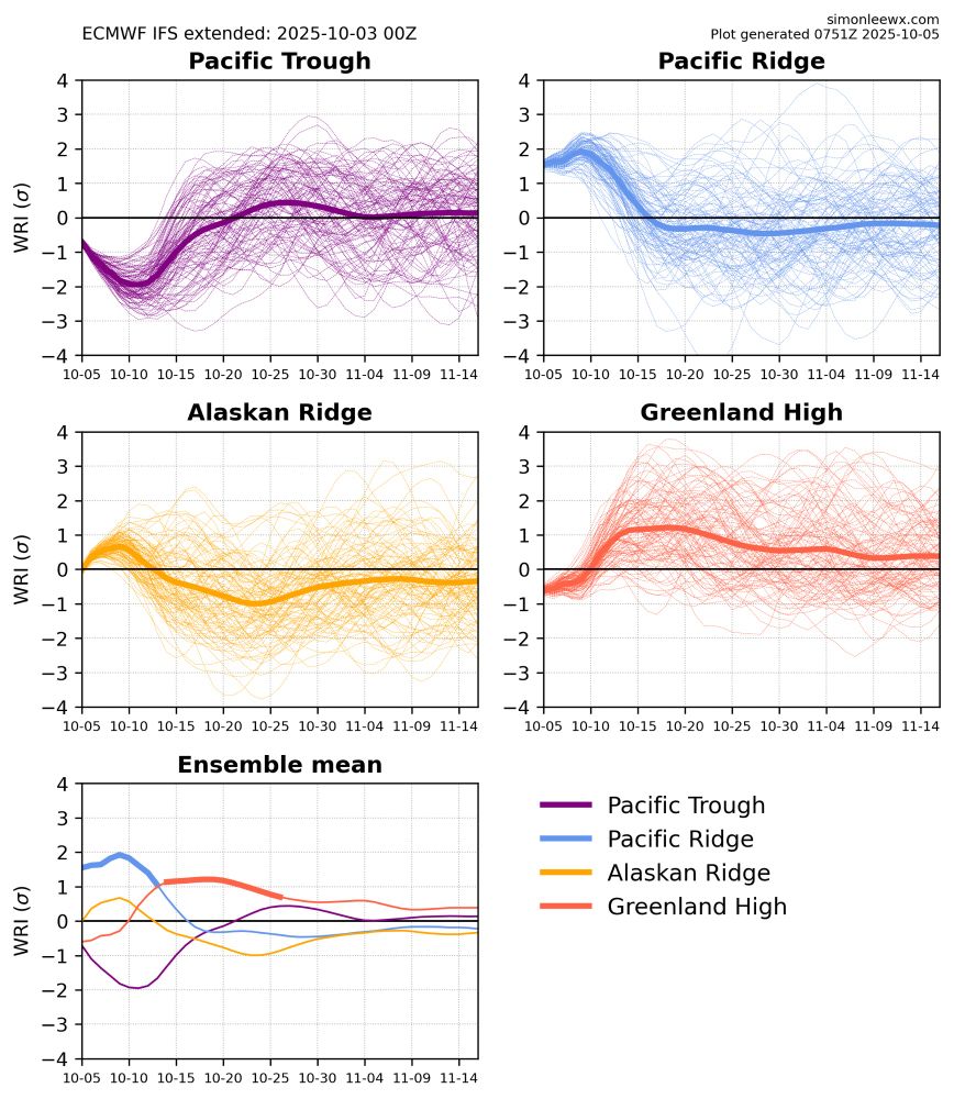
The west–east temperature contrast across North America is a hallmark of the Pacific Ridge regime, which is currently at 1.5–2 standard deviations simonleewx.com/ecmwf_north_...
Weather Regime Index plots from the ECMWF IFS subseasonal ensemble
edwardsanthonyb.bsky.social
Kuroshio Extension region... 🤔
edwardsanthonyb.bsky.social
Potential tropical cyclone remnants and broad area of low pressure in the middle latitudes supports a tilt in the odds toward wet weather across the West next week, particularly the Desert Southwest and Southern California. #CAwx #AZwx
Reposted by Anthony Edwards
cssl.bsky.social
10/2/25 10:25am

No snow yet but plenty of rain over the last 24 hours, which is a great start to the 2026 water year that began yesterday.

These early rain storms help prime our soil and keep it moist meaning less water from our snow has to do that job later.

#CAwx #CAwater
Reposted by Anthony Edwards
eyesonsdskies.bsky.social
Good soaking today in the Bay Area. It's always nice to see early October rain anywhere in California to give at least a temporary reprieve from the usual fall fire danger. #CAwx
edwardsanthonyb.bsky.social
Luckily, this ended up being a pretty low-impact event. However, it can be a terrible headache when this occurs with stronger storms. These small "waves" can slow or stall the progression of an atmospheric river (such as Dec. 31, 2022), and cause major flooding without much warning.
edwardsanthonyb.bsky.social
Moisture was plentiful across the Bay Area the past few days, but what lacked until this AM was upward motion to convert water vapor to rain. That finally arrived as a wave developed along the front. Ahead of it, winds diverged in the upper atmosphere and converged near the ground=vertical lift&rain
edwardsanthonyb.bsky.social
The federal government shut down on Wednesday for the first time since 2019, triggering a full stop for most research activities inside science agencies. Good overview from @aip.bsky.social
www.aip.org/fyi/federal-...
Federal Science on Pause Amid Shutdown
Most science agency staff will be furloughed, but federally funded extramural research can continue.
www.aip.org
Reposted by Anthony Edwards
cira-csu.bsky.social
Volcanic emissions from Kīlauea's 34th eruptive episode were lofted into the sky above the island of Hawai'i.
edwardsanthonyb.bsky.social
@paulkpix.bsky.social looks like traffic pattern has flipped, with only one meteorologist at the Oakland CWSU this might be more of a problem heading into offshore wind season as the replacement meteorologists are not working in-person at the Fremont FAA office
edwardsanthonyb.bsky.social
Not a clue. Will look into it.

I know air traffic control can be impacted by shutdown
Reposted by Anthony Edwards
circle-and-square.bsky.social
Dramatic rainshower over the Berkeley Marina yesterday evening as our next system arrives #CAwx