


Ethan Emery
@ethanemerywx.bsky.social
Communications Specialist & Meteorologist
Dayton, OH
Ohio University & Southern State Community College Alum. Environmental Science, Cincy Sports & Amateur Botany Geek. Not in that particular order. Appalachian in SW Ohio.
Kentucky Colonel
He/Him/His
Dayton, OH
Ohio University & Southern State Community College Alum. Environmental Science, Cincy Sports & Amateur Botany Geek. Not in that particular order. Appalachian in SW Ohio.
Kentucky Colonel
He/Him/His
WINTER STORM WATCH for Miami Valley from Saturday AM through Sunday AM
Heavy snow possible. Total snow accumulations 3-6” possible. ❄️
Heavy snow possible. Total snow accumulations 3-6” possible. ❄️

December 11, 2025 at 7:29 PM
WINTER STORM WATCH for Miami Valley from Saturday AM through Sunday AM
Heavy snow possible. Total snow accumulations 3-6” possible. ❄️
Heavy snow possible. Total snow accumulations 3-6” possible. ❄️
Reposted by Ethan Emery

DAYTON OH Dec 9
Climate Report:
High: 41
Low: 15
Precip: 0.0"
Snow: 0.0" Snow Depth: 0"
at Tue, 09 Dec 2025 21:50:44 +0000 via IEMbot
Additional Details Here.
Climate Report:
High: 41
Low: 15
Precip: 0.0"
Snow: 0.0" Snow Depth: 0"
at Tue, 09 Dec 2025 21:50:44 +0000 via IEMbot
Additional Details Here.
December 9, 2025 at 10:06 PM
DAYTON OH Dec 9
Climate Report:
High: 41
Low: 15
Precip: 0.0"
Snow: 0.0" Snow Depth: 0"
at Tue, 09 Dec 2025 21:50:44 +0000 via IEMbot
Additional Details Here.
Climate Report:
High: 41
Low: 15
Precip: 0.0"
Snow: 0.0" Snow Depth: 0"
at Tue, 09 Dec 2025 21:50:44 +0000 via IEMbot
Additional Details Here.
2.8” of snow on Tuesday in Dayton with 0.6” happening Monday night, giving us an event total of 3.6”, about what we expected from that system!
We’ve got very light snow tonight into Thursday morning (less than 0.5”) and perhaps a few flurries Friday afternoon.
Headline is COLD next several days! 🥶
We’ve got very light snow tonight into Thursday morning (less than 0.5”) and perhaps a few flurries Friday afternoon.
Headline is COLD next several days! 🥶
ILN issues Record Event Report (RER) at Dec 3, 12:32 AM EST ...RECORD DAILY MAXIMUM SNOWFALL SET AT DAYTON OH... via IEMbot
Additional Details Here.
Additional Details Here.
December 3, 2025 at 7:47 PM
2.8” of snow on Tuesday in Dayton with 0.6” happening Monday night, giving us an event total of 3.6”, about what we expected from that system!
We’ve got very light snow tonight into Thursday morning (less than 0.5”) and perhaps a few flurries Friday afternoon.
Headline is COLD next several days! 🥶
We’ve got very light snow tonight into Thursday morning (less than 0.5”) and perhaps a few flurries Friday afternoon.
Headline is COLD next several days! 🥶
Blustery winds, bone-chilling cold and winter weather are on the way!
Click the link to read more and watch the latest #StormTeam2 #CertifiedMostAccurateForecast! @wdtn2.bsky.social #ohwx #daytonwx #daywx
Click the link to read more and watch the latest #StormTeam2 #CertifiedMostAccurateForecast! @wdtn2.bsky.social #ohwx #daytonwx #daywx
www.wdtn.com
November 29, 2025 at 1:09 AM
Blustery winds, bone-chilling cold and winter weather are on the way!
Click the link to read more and watch the latest #StormTeam2 #CertifiedMostAccurateForecast! @wdtn2.bsky.social #ohwx #daytonwx #daywx
Click the link to read more and watch the latest #StormTeam2 #CertifiedMostAccurateForecast! @wdtn2.bsky.social #ohwx #daytonwx #daywx


3.6” of snow today at Dayton - impressive for early November!
Some locations in the Miami Valley received over 4” of snowfall while many had 2-3”
Some locations in the Miami Valley received over 4” of snowfall while many had 2-3”
#ILN issues Record Event Report (RER) at Nov 10, 4:58 PM EST ...RECORD DAILY MAXIMUM SNOWFALL SET AT DAYTON OH... Link
November 10, 2025 at 11:33 PM
3.6” of snow today at Dayton - impressive for early November!
Some locations in the Miami Valley received over 4” of snowfall while many had 2-3”
Some locations in the Miami Valley received over 4” of snowfall while many had 2-3”
Reposted by Ethan Emery

While this weekend's snow isn't expected to amount to much, now's a good time to check to make sure your process for managing your school/church/business closings is up to date. Need help? Email us at [email protected]

November 7, 2025 at 5:30 PM
While this weekend's snow isn't expected to amount to much, now's a good time to check to make sure your process for managing your school/church/business closings is up to date. Need help? Email us at [email protected]
Reposted by Ethan Emery

If you're having a hard day, just stop and remember this. ❤️
September 18, 2025 at 7:18 PM
If you're having a hard day, just stop and remember this. ❤️
Reposted by Ethan Emery
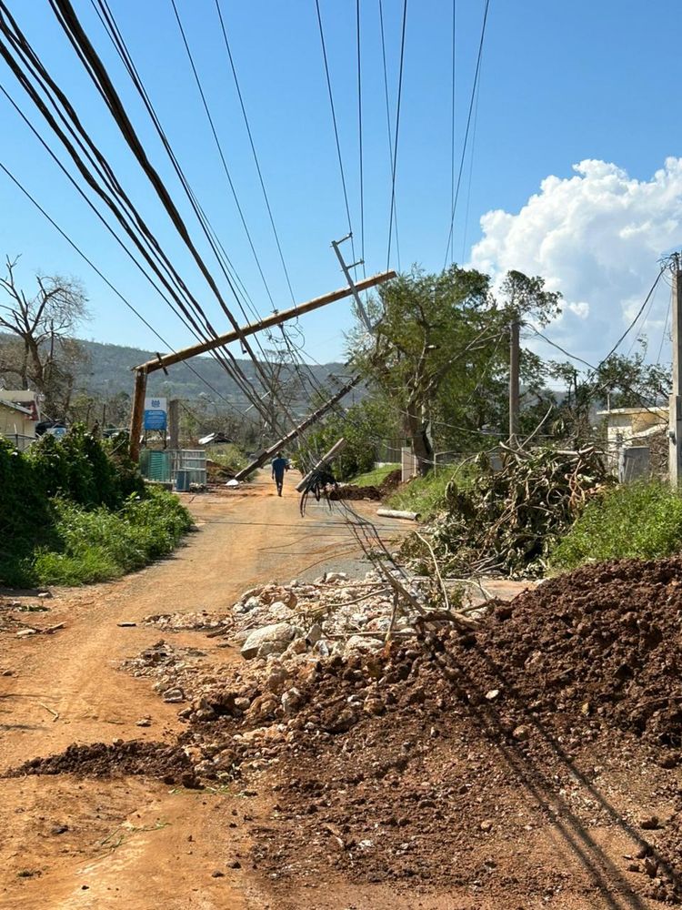
Hurricane Melissa tore through Jamaica as a Category 5 storm, leaving behind heartbreaking destruction. The Jamaica Red Cross prepositioned relief supplies before the storm, and teams are now supporting shelters and operating ambulances to respond to health emergencies.


October 31, 2025 at 8:00 PM
Hurricane Melissa tore through Jamaica as a Category 5 storm, leaving behind heartbreaking destruction. The Jamaica Red Cross prepositioned relief supplies before the storm, and teams are now supporting shelters and operating ambulances to respond to health emergencies.
Reposted by Ethan Emery

Atlantic Hurricane Melissa Advisory Number 29...corrected (corrected) issued at Tue, 28 Oct 2025 14:59:04 +0000
...EXTREMELY DANGEROUS CATEGORY 5 MELISSA ABOUT TO MAKE LANDFALL IN JAMAICA... ...CATASTROPHIC WINDS, FLASH FLOODING, AND STORM SURGE OCCURRING ON THE IS...
Additional Details Here.
...EXTREMELY DANGEROUS CATEGORY 5 MELISSA ABOUT TO MAKE LANDFALL IN JAMAICA... ...CATASTROPHIC WINDS, FLASH FLOODING, AND STORM SURGE OCCURRING ON THE IS...
Additional Details Here.


October 28, 2025 at 3:00 PM
Atlantic Hurricane Melissa Advisory Number 29...corrected (corrected) issued at Tue, 28 Oct 2025 14:59:04 +0000
...EXTREMELY DANGEROUS CATEGORY 5 MELISSA ABOUT TO MAKE LANDFALL IN JAMAICA... ...CATASTROPHIC WINDS, FLASH FLOODING, AND STORM SURGE OCCURRING ON THE IS...
Additional Details Here.
...EXTREMELY DANGEROUS CATEGORY 5 MELISSA ABOUT TO MAKE LANDFALL IN JAMAICA... ...CATASTROPHIC WINDS, FLASH FLOODING, AND STORM SURGE OCCURRING ON THE IS...
Additional Details Here.
Reposted by Ethan Emery

For discussion later via @subletteweather.com

October 28, 2025 at 3:02 PM
For discussion later via @subletteweather.com
Reposted by Ethan Emery

#Melissa making landfall in Jamaica shortly. Ties for 3rd strongest hurricane in the Atlantic by pressure (892 mb), 2nd by wind speed (185 mph).
October 28, 2025 at 2:53 PM
#Melissa making landfall in Jamaica shortly. Ties for 3rd strongest hurricane in the Atlantic by pressure (892 mb), 2nd by wind speed (185 mph).
I’m sick to my stomach seeing this for the people of Jamaica… Hurricane Melissa is tied for the third strongest Atlantic hurricane on record (892mb) and the 10am winds were sustained at 185 mph with gusts over 200mph. #Melissa #HurricaneMelissa
October 28, 2025 at 2:36 PM
I’m sick to my stomach seeing this for the people of Jamaica… Hurricane Melissa is tied for the third strongest Atlantic hurricane on record (892mb) and the 10am winds were sustained at 185 mph with gusts over 200mph. #Melissa #HurricaneMelissa
Reposted by Ethan Emery

The 2pm ET public update advisory for Hurricane Melissa has the central pressure down to 906 mb with peak winds of 175 mph. This makes Melissa the 10th strongest hurricane in record in the Atlantic Basin.

October 27, 2025 at 6:25 PM
The 2pm ET public update advisory for Hurricane Melissa has the central pressure down to 906 mb with peak winds of 175 mph. This makes Melissa the 10th strongest hurricane in record in the Atlantic Basin.
Reposted by Ethan Emery

Melissa has intensified into a category 4 hurricane and could develop further to become a category 5 as it approaches Jamaica.

Category 4 Hurricane Melissa threatens catastrophic flooding in Jamaica and Haiti
Melissa has intensified into a category 4 hurricane and could develop further to become a category 5 as it approaches Jamaica.
n.pr
October 26, 2025 at 2:17 PM
Melissa has intensified into a category 4 hurricane and could develop further to become a category 5 as it approaches Jamaica.
Reposted by Ethan Emery

NOAA’s National Weather Service Winter Outlook has been released.
This outlook shows the likely temperature and precipitation the U.S. could experience during meteorological winter (December 1, 2025 through February 28, 2026) and drought conditions through January 31, 2026.
This outlook shows the likely temperature and precipitation the U.S. could experience during meteorological winter (December 1, 2025 through February 28, 2026) and drought conditions through January 31, 2026.
October 16, 2025 at 3:05 PM
NOAA’s National Weather Service Winter Outlook has been released.
This outlook shows the likely temperature and precipitation the U.S. could experience during meteorological winter (December 1, 2025 through February 28, 2026) and drought conditions through January 31, 2026.
This outlook shows the likely temperature and precipitation the U.S. could experience during meteorological winter (December 1, 2025 through February 28, 2026) and drought conditions through January 31, 2026.
Reposted by Ethan Emery
While La Niña is currently expected to remain weak, it could still influence the 2025-26 winter season. See what a typical winter La Niña pattern looks like across the U.S.
For more information visit cpc.ncep.noaa.gov.
(3/3)
For more information visit cpc.ncep.noaa.gov.
(3/3)


October 9, 2025 at 1:15 PM
While La Niña is currently expected to remain weak, it could still influence the 2025-26 winter season. See what a typical winter La Niña pattern looks like across the U.S.
For more information visit cpc.ncep.noaa.gov.
(3/3)
For more information visit cpc.ncep.noaa.gov.
(3/3)
Reposted by Ethan Emery
La Niña conditions are expected to continue through the December 2025 to February 2026 timeframe. A transition to ENSO-neutral conditions, meaning neither El Niño nor La Niña conditions, is most likely in the January 2026 to March 2026 timeframe.
(2/3)
(2/3)

October 9, 2025 at 1:15 PM
La Niña conditions are expected to continue through the December 2025 to February 2026 timeframe. A transition to ENSO-neutral conditions, meaning neither El Niño nor La Niña conditions, is most likely in the January 2026 to March 2026 timeframe.
(2/3)
(2/3)
Reposted by Ethan Emery
A La Niña Advisory has been issued, meaning that La Niña conditions have been observed in the tropical Pacific Ocean.
(1/3)
(1/3)


October 9, 2025 at 1:15 PM
A La Niña Advisory has been issued, meaning that La Niña conditions have been observed in the tropical Pacific Ocean.
(1/3)
(1/3)
FROST ADVISORY in effect for the #MiamiValley tonight!
Details below in the link! #ohwx #daywx #daytonwx
Details below in the link! #ohwx #daywx #daytonwx
ILN issues Frost Advisory valid at Oct 10, 2:00 AM EDT till Oct 10, 9:00 AM EDT Link

October 9, 2025 at 8:02 PM
FROST ADVISORY in effect for the #MiamiValley tonight!
Details below in the link! #ohwx #daywx #daytonwx
Details below in the link! #ohwx #daywx #daytonwx
Yup. Got it. Not going to do it, either.
S/O @onelegbrynn.bsky.social for being the first post to pop up on my feed this morning 😂
S/O @onelegbrynn.bsky.social for being the first post to pop up on my feed this morning 😂

September 30, 2025 at 12:40 PM
Yup. Got it. Not going to do it, either.
S/O @onelegbrynn.bsky.social for being the first post to pop up on my feed this morning 😂
S/O @onelegbrynn.bsky.social for being the first post to pop up on my feed this morning 😂
Reposted by Ethan Emery

Do football players really need pads and a helmet?

September 28, 2025 at 1:25 AM
Do football players really need pads and a helmet?
Strong wind gusts possible this afternoon!
The Storm Prediction Center has issued a slight risk (level 2 out of 5) for severe weather. With this risk, the main impact is the potential for damaging wind gusts with secondary, low threats of hail or brief tornado chance.
I’m only concerned for winds
The Storm Prediction Center has issued a slight risk (level 2 out of 5) for severe weather. With this risk, the main impact is the potential for damaging wind gusts with secondary, low threats of hail or brief tornado chance.
I’m only concerned for winds

September 22, 2025 at 1:16 PM
Strong wind gusts possible this afternoon!
The Storm Prediction Center has issued a slight risk (level 2 out of 5) for severe weather. With this risk, the main impact is the potential for damaging wind gusts with secondary, low threats of hail or brief tornado chance.
I’m only concerned for winds
The Storm Prediction Center has issued a slight risk (level 2 out of 5) for severe weather. With this risk, the main impact is the potential for damaging wind gusts with secondary, low threats of hail or brief tornado chance.
I’m only concerned for winds
Strong winds in showers/thunderstorms is possible Sunday in the Miami Valley!
Marginal risk (level 1/5) has been issued by the Storm Prediction Center due to the low-end risk of severe wind gusts.
This is the beginning of a pattern change that will bring rain chances next week! 🙂
Marginal risk (level 1/5) has been issued by the Storm Prediction Center due to the low-end risk of severe wind gusts.
This is the beginning of a pattern change that will bring rain chances next week! 🙂
#SPC issues Day 2 Marginal Convective Risk at Sep 20, 17:29z for ILN Link

September 21, 2025 at 2:28 AM
Strong winds in showers/thunderstorms is possible Sunday in the Miami Valley!
Marginal risk (level 1/5) has been issued by the Storm Prediction Center due to the low-end risk of severe wind gusts.
This is the beginning of a pattern change that will bring rain chances next week! 🙂
Marginal risk (level 1/5) has been issued by the Storm Prediction Center due to the low-end risk of severe wind gusts.
This is the beginning of a pattern change that will bring rain chances next week! 🙂
MODERATE DROUGHT conditions are present in all of the Miami Valley!
The US Drought Monitor was updated earlier this morning, and drought conditions have worsened.
The #StormTeam2 #CertifiedMostAccurate forecast keeps us dry through the weekend!
@wdtn2.bsky.social
#daywx #daytonwx #ohwx #drought
The US Drought Monitor was updated earlier this morning, and drought conditions have worsened.
The #StormTeam2 #CertifiedMostAccurate forecast keeps us dry through the weekend!
@wdtn2.bsky.social
#daywx #daytonwx #ohwx #drought


September 18, 2025 at 2:51 PM
MODERATE DROUGHT conditions are present in all of the Miami Valley!
The US Drought Monitor was updated earlier this morning, and drought conditions have worsened.
The #StormTeam2 #CertifiedMostAccurate forecast keeps us dry through the weekend!
@wdtn2.bsky.social
#daywx #daytonwx #ohwx #drought
The US Drought Monitor was updated earlier this morning, and drought conditions have worsened.
The #StormTeam2 #CertifiedMostAccurate forecast keeps us dry through the weekend!
@wdtn2.bsky.social
#daywx #daytonwx #ohwx #drought