


Jim Sullivan
@jimsullivan.bsky.social
Meteorologist at NWS Cleveland. I forecast the weather with mixed results. Thoughts and views are my own. Fork off.
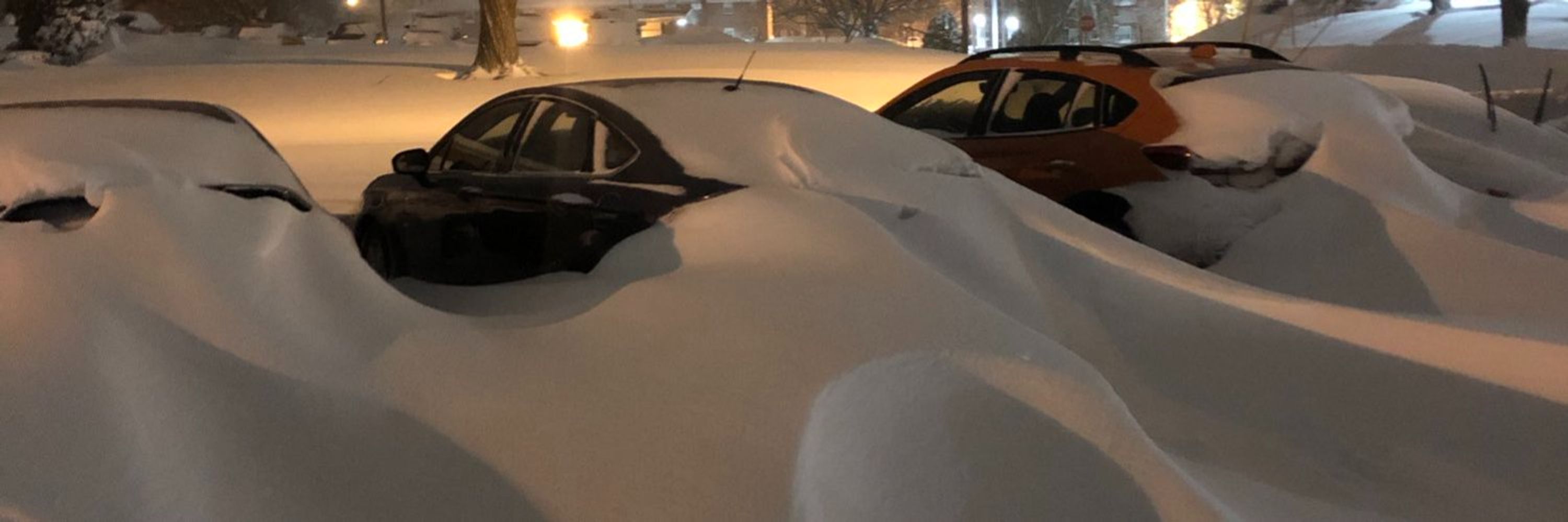
First real tap of arctic air of the season into the Great Lakes Sunday and Monday. The lakes still have plenty of warmth and will be primed to go beneath this cold air, with the airmass cold enough for the ptype to be mainly snow. It'll be a quick shot, but some accumulating lake effect is likely.
November 5, 2025 at 1:40 AM
First real tap of arctic air of the season into the Great Lakes Sunday and Monday. The lakes still have plenty of warmth and will be primed to go beneath this cold air, with the airmass cold enough for the ptype to be mainly snow. It'll be a quick shot, but some accumulating lake effect is likely.
The CDO is very large, symmetric, cold and expanding, and the eye remains very sharp and warm. Recon confirms the satellite trends and suggests that Hurricane Melissa is deepening at the moment. This is just unimaginably bad for Jamaica.
October 28, 2025 at 4:35 AM
The CDO is very large, symmetric, cold and expanding, and the eye remains very sharp and warm. Recon confirms the satellite trends and suggests that Hurricane Melissa is deepening at the moment. This is just unimaginably bad for Jamaica.
Shear and mid-level dry air caused Kiko's convection to collapse this evening. Resultant gravity waves propagated away from the convection, briefly disrupting shallow cumulus within Kiko's low-level circulation. These cumulus suggest fluxes are trying to re-moisten the circulation, a slow process.
September 10, 2025 at 5:59 AM
Shear and mid-level dry air caused Kiko's convection to collapse this evening. Resultant gravity waves propagated away from the convection, briefly disrupting shallow cumulus within Kiko's low-level circulation. These cumulus suggest fluxes are trying to re-moisten the circulation, a slow process.
The trough that carves out over central Canada, the Upper Midwest and northern Great Lakes this upcoming week has origins north of Alaska early in the loop.
For whatever THAT'S worth at the beginning of September.
Some early signs of the changing of the seasons this year.
For whatever THAT'S worth at the beginning of September.
Some early signs of the changing of the seasons this year.
August 31, 2025 at 12:29 AM
The trough that carves out over central Canada, the Upper Midwest and northern Great Lakes this upcoming week has origins north of Alaska early in the loop.
For whatever THAT'S worth at the beginning of September.
Some early signs of the changing of the seasons this year.
For whatever THAT'S worth at the beginning of September.
Some early signs of the changing of the seasons this year.
Erin was a very impressive hurricane at peak on Saturday. Still was a compact storm, which helped minimize interaction with lingering dry air to the north of the center. And it had a tight, violent, essentially uninterrupted inner core until an ERC took place, allowing for explosive intensification.
August 17, 2025 at 4:50 AM
Erin was a very impressive hurricane at peak on Saturday. Still was a compact storm, which helped minimize interaction with lingering dry air to the north of the center. And it had a tight, violent, essentially uninterrupted inner core until an ERC took place, allowing for explosive intensification.
I must admit that lake enhanced precip on the scope doesn’t warm my heart quite as much in late May as it does between October and April.
May 22, 2025 at 2:48 PM
I must admit that lake enhanced precip on the scope doesn’t warm my heart quite as much in late May as it does between October and April.
As an unapologetic snow lover, it's a thing of beauty. Impressively cold air for April 8th spilling over lakes that have actually warmed slightly over the last couple weeks, setting off late-season lake effect snow. Not common but not super rare. The snow coming off of Lake Huron is fairly intense.
April 8, 2025 at 4:52 AM
As an unapologetic snow lover, it's a thing of beauty. Impressively cold air for April 8th spilling over lakes that have actually warmed slightly over the last couple weeks, setting off late-season lake effect snow. Not common but not super rare. The snow coming off of Lake Huron is fairly intense.
Convection from Lake Erie into the upper Ohio Valley is strongly-forced ahead of a vort max & beneath strongly diffluent flow aloft. Cloud breaks are allowing for gradual destabilization as the forcing presses east, leading to a continued increase in the severe potential over the next few hours.
March 16, 2025 at 3:50 PM
Convection from Lake Erie into the upper Ohio Valley is strongly-forced ahead of a vort max & beneath strongly diffluent flow aloft. Cloud breaks are allowing for gradual destabilization as the forcing presses east, leading to a continued increase in the severe potential over the next few hours.
Strongest forcing across the Upper MS Valley with strongest instability in the Lower MS Valley. Activity that evolves across E-Cntrl/SE MO, N-Cntrl/NE AR, Cntrl/S IL, and W KY will be in the sweet spot of more moderate forcing and instability w/extreme shear. Activity in MS is more weakly forced.
March 15, 2025 at 12:56 AM
Strongest forcing across the Upper MS Valley with strongest instability in the Lower MS Valley. Activity that evolves across E-Cntrl/SE MO, N-Cntrl/NE AR, Cntrl/S IL, and W KY will be in the sweet spot of more moderate forcing and instability w/extreme shear. Activity in MS is more weakly forced.
This little band of fgen snow is probably a top 4 synoptic (i.e. not lake driven) snow event for northern OH this winter. A few 2.5-3.5” reports so far.
March 8, 2025 at 1:13 AM
This little band of fgen snow is probably a top 4 synoptic (i.e. not lake driven) snow event for northern OH this winter. A few 2.5-3.5” reports so far.
The lake enhanced snow continues to scoff at the ice on Lake Erie this morning. There’s definitely some subtle convergence focusing the snow in the vicinity of Cuyahoga County, where there have been a handful of 2-3” reports since last night.
February 20, 2025 at 3:07 PM
The lake enhanced snow continues to scoff at the ice on Lake Erie this morning. There’s definitely some subtle convergence focusing the snow in the vicinity of Cuyahoga County, where there have been a handful of 2-3” reports since last night.
Despite Lake Erie being 95% ice-covered, I’ve gotten a bit over an inch of very fluffy lake effect/enhanced snow over the last few hours. With temperatures in the low-mid 10s and about 4” of snow already on the ground, it’s quite a wintry night. Stuff like this is why I enjoy winter around here.
February 20, 2025 at 5:47 AM
Despite Lake Erie being 95% ice-covered, I’ve gotten a bit over an inch of very fluffy lake effect/enhanced snow over the last few hours. With temperatures in the low-mid 10s and about 4” of snow already on the ground, it’s quite a wintry night. Stuff like this is why I enjoy winter around here.