


Jason Nicholls
@jnmet.bsky.social
Lead International Forecaster/Senior Meteorologist/International forecasting manager @AccuWeather. Long range/global forecaster. NVU-Lyndon grad; proud dad
A ridge building near the Northern Mariana Islands is turning #Fung-wong/#Uwan northward with a northeastward turn expected Tuesday night, local time. Fung-wong is expected to make another landfall in western #Taiwan Wednesday night, local time.

November 10, 2025 at 2:27 PM
A ridge building near the Northern Mariana Islands is turning #Fung-wong/#Uwan northward with a northeastward turn expected Tuesday night, local time. Fung-wong is expected to make another landfall in western #Taiwan Wednesday night, local time.
Rainfall will remain light & spotty in southern #AndhraPradesh, #TamilNadu, #Puducherry, #Kerala & #SriLanka through the weekend. There can be an uptick in rainfall in these areas early next week. Risk for a low to form in the Bay of Bengal late next week.


November 10, 2025 at 12:36 PM
Rainfall will remain light & spotty in southern #AndhraPradesh, #TamilNadu, #Puducherry, #Kerala & #SriLanka through the weekend. There can be an uptick in rainfall in these areas early next week. Risk for a low to form in the Bay of Bengal late next week.
The outer bands of #Fung-wong is already bring some rain to #Taiwan with upsloping enhancing the rain in the east. Rain, some heavy, will continue across Taiwan into Thursday, local time.

November 10, 2025 at 11:13 AM
The outer bands of #Fung-wong is already bring some rain to #Taiwan with upsloping enhancing the rain in the east. Rain, some heavy, will continue across Taiwan into Thursday, local time.
#Fung-wong/#Uwan is now a severe tropical storm after crossing #Luzon. A turn to the north then northeast over the next day or two with another landfall in #Taiwan Sunday night.

November 10, 2025 at 8:22 AM
#Fung-wong/#Uwan is now a severe tropical storm after crossing #Luzon. A turn to the north then northeast over the next day or two with another landfall in #Taiwan Sunday night.
Typhoons #Kalmaegi/#Tino & #Fung-wong/#Uwan resulted in some cooling of sea-surface temperatures in the Philippine Sea over the past week. However, sea-surface temperatures remain warmer than usual.

November 9, 2025 at 3:22 PM
Typhoons #Kalmaegi/#Tino & #Fung-wong/#Uwan resulted in some cooling of sea-surface temperatures in the Philippine Sea over the past week. However, sea-surface temperatures remain warmer than usual.
Isolated to scattered rains on southern #AndhraPradesh, #TamilNadu, #Puducherry, #Kerala & #SriLanka over the next few days. Watch for a low to form in the southern Bay of Bengal later the week of 17 Nov.

November 9, 2025 at 2:04 PM
Isolated to scattered rains on southern #AndhraPradesh, #TamilNadu, #Puducherry, #Kerala & #SriLanka over the next few days. Watch for a low to form in the southern Bay of Bengal later the week of 17 Nov.
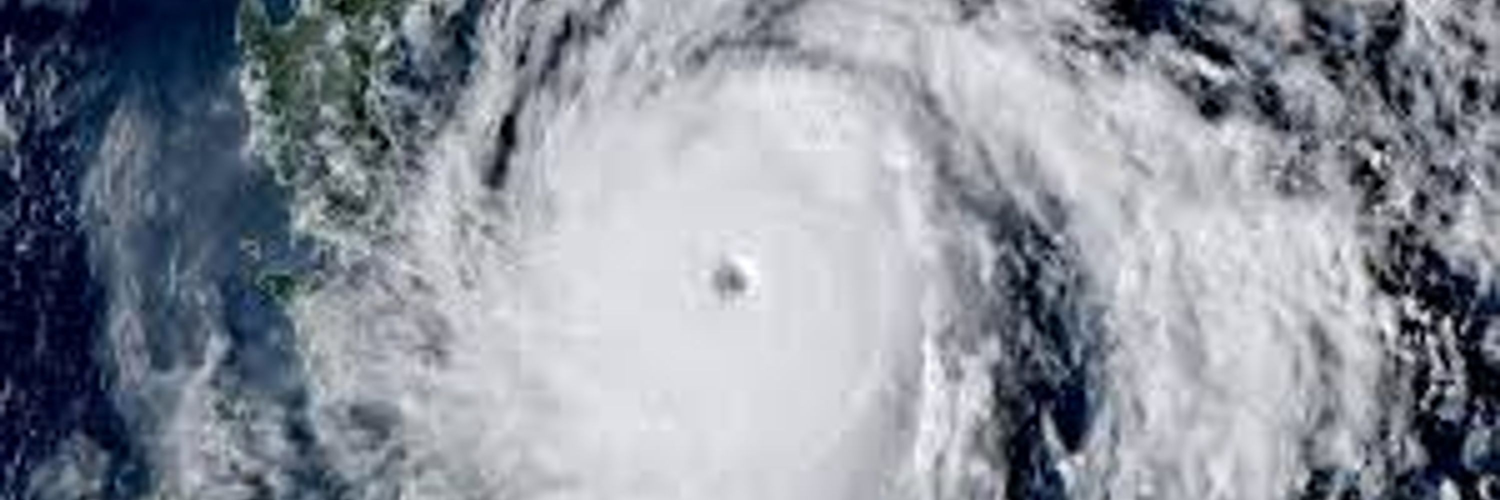
Powerful Typhoon #Fung-wong/#Uwan is making landfall between Dipaculao and Dinadiawan Beach in #Luzon. The storm will emerge off the west coast of Luzon on Monday, local time.

November 9, 2025 at 1:06 PM
Powerful Typhoon #Fung-wong/#Uwan is making landfall between Dipaculao and Dinadiawan Beach in #Luzon. The storm will emerge off the west coast of Luzon on Monday, local time.


Typhoon Fung-wong/#Uwan continues to strengthen & can become a super typhoon striking #Luzon Sunday night, local time. The storm will ride the periphery of a ridge building near the Mariana Islands, causing a turn to the N & NE early next week. Possible impacts on #Taiwan around midweek.

November 8, 2025 at 2:38 AM
Typhoon Fung-wong/#UwanPH continues to strengthen and can reach super typhoon intensity before striking the northern #Philippines Sunday night, local time. The storm is expected to turn north & northeast early next week, possibly impacting #Taiwan around midweek.

November 7, 2025 at 3:31 PM
Typhoon Fung-wong/#UwanPH continues to strengthen and can reach super typhoon intensity before striking the northern #Philippines Sunday night, local time. The storm is expected to turn north & northeast early next week, possibly impacting #Taiwan around midweek.
A low will bring light rain & thunder to central #Chile Thursday afternoon/night. Rainfall around #Santiago should be less than 4 mm. This feature can result in areas of heavy rain & strong thunderstorms in northern #Argentina, #Uruguay & southeast #Brazil Friday into Saturday.

November 6, 2025 at 3:20 PM
A low will bring light rain & thunder to central #Chile Thursday afternoon/night. Rainfall around #Santiago should be less than 4 mm. This feature can result in areas of heavy rain & strong thunderstorms in northern #Argentina, #Uruguay & southeast #Brazil Friday into Saturday.

Strengthening Tropical Storm Fung-wong will become a typhoon in the next 24-hours then may reach super typhoon intensity before striking the northern #Philippines Sunday night, local time. The storm will turn back toward the northeast & may impact #Taiwan around midweek.

November 6, 2025 at 12:41 PM
Strengthening Tropical Storm Fung-wong will become a typhoon in the next 24-hours then may reach super typhoon intensity before striking the northern #Philippines Sunday night, local time. The storm will turn back toward the northeast & may impact #Taiwan around midweek.

Tropical Storm Fung-wong has formed near Yap Island and will likely strengthen to a strong typhoon before striking the northern #Philippines early next week.

November 5, 2025 at 9:55 PM
Tropical Storm Fung-wong has formed near Yap Island and will likely strengthen to a strong typhoon before striking the northern #Philippines early next week.
A low near Juan Fernández archipelago will bring light rain & thunder to C #Chile Thursday afternoon/night. Rainfall around #Santiago should be less than 4 mm. This feature can result in areas of heavy rain & strong thunderstorms in N #Argentina, #Uruguay & SE #Brazil Friday into Saturday.

November 5, 2025 at 2:14 PM
A low near Juan Fernández archipelago will bring light rain & thunder to C #Chile Thursday afternoon/night. Rainfall around #Santiago should be less than 4 mm. This feature can result in areas of heavy rain & strong thunderstorms in N #Argentina, #Uruguay & SE #Brazil Friday into Saturday.
A tropical depression east-southeast of Yap Island will become TS Fung-wong Wednesday night, local time. Fung-wong/#UwanPH is expected to become a super typhoon before reaching the northern #Philippines early next week.

November 5, 2025 at 1:32 PM
A tropical depression east-southeast of Yap Island will become TS Fung-wong Wednesday night, local time. Fung-wong/#UwanPH is expected to become a super typhoon before reaching the northern #Philippines early next week.
A weakening low will continue to bring areas of rain to eastern #Bangladesh, northwest #Myanmar & far northeast #India into Thursday.

November 5, 2025 at 11:26 AM
A weakening low will continue to bring areas of rain to eastern #Bangladesh, northwest #Myanmar & far northeast #India into Thursday.
Typhoon #Kalmaegi/#TinoPH is over the South China Sea and will strengthen before making another landfall in southern #Vietnam Thursday night, local time.

November 5, 2025 at 8:36 AM
Typhoon #Kalmaegi/#TinoPH is over the South China Sea and will strengthen before making another landfall in southern #Vietnam Thursday night, local time.
A strong shortwave will bring light rain & thunder to C #Chile Thursday afternoon/night. Rainfall around #Santiago should be less than 4 mm. This feature can result in areas of heavy rain & strong thunderstorms in N #Argentina, #Uruguay & SE #Brazil from Thursday night into Saturday.

November 4, 2025 at 2:06 PM
A strong shortwave will bring light rain & thunder to C #Chile Thursday afternoon/night. Rainfall around #Santiago should be less than 4 mm. This feature can result in areas of heavy rain & strong thunderstorms in N #Argentina, #Uruguay & SE #Brazil from Thursday night into Saturday.
Typhoon #Kalmaegi/#TinoPH is over the Sulu Sea & will pass near northern #Palawan late Tuesday night/early Wednesday, local time. Kalmaegi will strengthen before reaching southern #Vietnam Thursday night, local time.

November 4, 2025 at 12:34 PM
Typhoon #Kalmaegi/#TinoPH is over the Sulu Sea & will pass near northern #Palawan late Tuesday night/early Wednesday, local time. Kalmaegi will strengthen before reaching southern #Vietnam Thursday night, local time.
A well-marked low is near the northeast coast of #Myanmar will drift north-northwest resulting is areas of heavy rain in northeast Myanmar, eastern #Bangladesh and far northeast #India through Wednesday.

November 4, 2025 at 11:12 AM
A well-marked low is near the northeast coast of #Myanmar will drift north-northwest resulting is areas of heavy rain in northeast Myanmar, eastern #Bangladesh and far northeast #India through Wednesday.
Typhoon #Kalmaegi/#Tino is passing near the Philippine island of #Panay while a new tropical depression is passing south of #Guam. Kalmaegi will push into southern #Vietnam Thursday night while the new cyclone can impact the northern Philippines or Taiwan early next week.

November 4, 2025 at 8:23 AM
Typhoon #Kalmaegi/#Tino is passing near the Philippine island of #Panay while a new tropical depression is passing south of #Guam. Kalmaegi will push into southern #Vietnam Thursday night while the new cyclone can impact the northern Philippines or Taiwan early next week.
