


Joe Boomgard-Zagrodnik
@joeboomzag.bsky.social
Pacific Northwest weather/climate forecasts. Website: theconvergencezone.com
The cold/dry spell is nearly over for Seattle.
The next pattern shift will bring seasonal precipitation and above normal temperatures.
It will really feel like spring by the first week of February.
The mountain snowfall outlook is bleak.
The next pattern shift will bring seasonal precipitation and above normal temperatures.
It will really feel like spring by the first week of February.
The mountain snowfall outlook is bleak.

January 24, 2026 at 7:38 PM
The cold/dry spell is nearly over for Seattle.
The next pattern shift will bring seasonal precipitation and above normal temperatures.
It will really feel like spring by the first week of February.
The mountain snowfall outlook is bleak.
The next pattern shift will bring seasonal precipitation and above normal temperatures.
It will really feel like spring by the first week of February.
The mountain snowfall outlook is bleak.
The last 5-6 days of T/Td at my house had almost no diurnal cycle while we were stuck under an inversion.
Today the warmth aloft finally mixed down to the ground and the temp is soaring into the mid-50s.
Today the warmth aloft finally mixed down to the ground and the temp is soaring into the mid-50s.

January 16, 2026 at 9:24 PM
The last 5-6 days of T/Td at my house had almost no diurnal cycle while we were stuck under an inversion.
Today the warmth aloft finally mixed down to the ground and the temp is soaring into the mid-50s.
Today the warmth aloft finally mixed down to the ground and the temp is soaring into the mid-50s.
Interesting 10 day forecast for Seattle with some ensemble members showing a cold snap and others projecting mild weather.
An arctic front is likely headed for the northern Plains/Rockies and the question is whether any of the arctic air will make it west of the Cascades or not.
An arctic front is likely headed for the northern Plains/Rockies and the question is whether any of the arctic air will make it west of the Cascades or not.


January 13, 2026 at 8:34 PM
Interesting 10 day forecast for Seattle with some ensemble members showing a cold snap and others projecting mild weather.
An arctic front is likely headed for the northern Plains/Rockies and the question is whether any of the arctic air will make it west of the Cascades or not.
An arctic front is likely headed for the northern Plains/Rockies and the question is whether any of the arctic air will make it west of the Cascades or not.
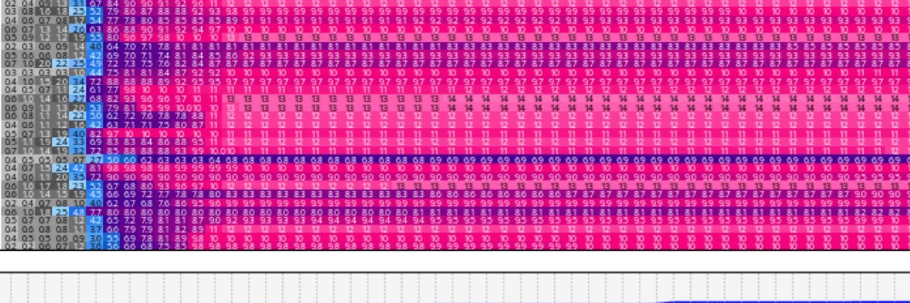
Same story for Washington (pictured) and Oregon.
Need 90th percentile snow from here on out to get to normal.
No snow coming anytime soon, so we'd need a record snowy Feb-Mar just to reach normal.
Hint: that ain't happening.
Need 90th percentile snow from here on out to get to normal.
No snow coming anytime soon, so we'd need a record snowy Feb-Mar just to reach normal.
Hint: that ain't happening.

January 13, 2026 at 7:44 PM
Same story for Washington (pictured) and Oregon.
Need 90th percentile snow from here on out to get to normal.
No snow coming anytime soon, so we'd need a record snowy Feb-Mar just to reach normal.
Hint: that ain't happening.
Need 90th percentile snow from here on out to get to normal.
No snow coming anytime soon, so we'd need a record snowy Feb-Mar just to reach normal.
Hint: that ain't happening.
The Space Needle is in there somewhere

January 1, 2026 at 5:03 AM
The Space Needle is in there somewhere
Potential X-mas eve windstorm update --
The European model has a weaker and more inland low resulting in mostly non-damaging winds.
The GFS ensembles are stronger and farther west, resulting in an event that could be damaging for many areas.
Probably will come down to a nowcast 🤷
The European model has a weaker and more inland low resulting in mostly non-damaging winds.
The GFS ensembles are stronger and farther west, resulting in an event that could be damaging for many areas.
Probably will come down to a nowcast 🤷


December 23, 2025 at 6:27 PM
Potential X-mas eve windstorm update --
The European model has a weaker and more inland low resulting in mostly non-damaging winds.
The GFS ensembles are stronger and farther west, resulting in an event that could be damaging for many areas.
Probably will come down to a nowcast 🤷
The European model has a weaker and more inland low resulting in mostly non-damaging winds.
The GFS ensembles are stronger and farther west, resulting in an event that could be damaging for many areas.
Probably will come down to a nowcast 🤷

A Christmas Eve windstorm is appearing increasingly likely with a compact 980 hPa low + trailing sting jet expected to take a troublesome S to N track. Willamette Valley, coast, PDX, SEA metros all potentially impacted.
Lots of model uncertainty…follow forecasts closely. Could be a bad one.
Lots of model uncertainty…follow forecasts closely. Could be a bad one.

December 22, 2025 at 2:47 PM
A Christmas Eve windstorm is appearing increasingly likely with a compact 980 hPa low + trailing sting jet expected to take a troublesome S to N track. Willamette Valley, coast, PDX, SEA metros all potentially impacted.
Lots of model uncertainty…follow forecasts closely. Could be a bad one.
Lots of model uncertainty…follow forecasts closely. Could be a bad one.
Watching a possible snow event for the WA lowlands on Christmas Eve.
Currently looks like a "dusting on the higher hills" type event for Seattle.
Areas north and at higher elevations have a better chance at seeing accumulating snow, but it's still too early to tell...
Currently looks like a "dusting on the higher hills" type event for Seattle.
Areas north and at higher elevations have a better chance at seeing accumulating snow, but it's still too early to tell...

December 19, 2025 at 6:59 PM
Watching a possible snow event for the WA lowlands on Christmas Eve.
Currently looks like a "dusting on the higher hills" type event for Seattle.
Areas north and at higher elevations have a better chance at seeing accumulating snow, but it's still too early to tell...
Currently looks like a "dusting on the higher hills" type event for Seattle.
Areas north and at higher elevations have a better chance at seeing accumulating snow, but it's still too early to tell...
"What if it was all snow?"
It was at one spot in Washington -- Harts Pass, the highest elevation SNOTEL site in the Washington Cascades.
Snowpack is now 173% of normal for the date. Last winter it took until March 14 to reach this level of snowpack.
It was at one spot in Washington -- Harts Pass, the highest elevation SNOTEL site in the Washington Cascades.
Snowpack is now 173% of normal for the date. Last winter it took until March 14 to reach this level of snowpack.

December 17, 2025 at 4:47 PM
"What if it was all snow?"
It was at one spot in Washington -- Harts Pass, the highest elevation SNOTEL site in the Washington Cascades.
Snowpack is now 173% of normal for the date. Last winter it took until March 14 to reach this level of snowpack.
It was at one spot in Washington -- Harts Pass, the highest elevation SNOTEL site in the Washington Cascades.
Snowpack is now 173% of normal for the date. Last winter it took until March 14 to reach this level of snowpack.
The Green River has a slower response to precipitation than other rivers in western WA, so it has continued to rise since last week's heavy rainfall

December 15, 2025 at 8:34 PM
The Green River has a slower response to precipitation than other rivers in western WA, so it has continued to rise since last week's heavy rainfall
The catastrophic flooding has been rough to handle, so here's some good news.
One more warm atmos river on Monday, then the Cascades are going to get pummeled with snow when cold air finally moves in next Wednesday.
Snoqualmie Pass could see 4 feet of snow by Christmas.
Skiing will be great.
One more warm atmos river on Monday, then the Cascades are going to get pummeled with snow when cold air finally moves in next Wednesday.
Snoqualmie Pass could see 4 feet of snow by Christmas.
Skiing will be great.

December 11, 2025 at 11:11 PM
The catastrophic flooding has been rough to handle, so here's some good news.
One more warm atmos river on Monday, then the Cascades are going to get pummeled with snow when cold air finally moves in next Wednesday.
Snoqualmie Pass could see 4 feet of snow by Christmas.
Skiing will be great.
One more warm atmos river on Monday, then the Cascades are going to get pummeled with snow when cold air finally moves in next Wednesday.
Snoqualmie Pass could see 4 feet of snow by Christmas.
Skiing will be great.
Here's a sampling of some rainfall totals since Monday morning if you were wondering why rivers are experiencing historic flooding in the WA Cascades. Normally one would expect at least some of this to fall as snow in the high terrain, but it was 100% rain in this area.

December 11, 2025 at 4:49 PM
Here's a sampling of some rainfall totals since Monday morning if you were wondering why rivers are experiencing historic flooding in the WA Cascades. Normally one would expect at least some of this to fall as snow in the high terrain, but it was 100% rain in this area.
Morning update: it rained all night and the Snohomish River is now above its modern record and still rising. For now the Snoqualmie River remains slightly below record level, but still in major flood stage.


December 11, 2025 at 3:27 PM
Morning update: it rained all night and the Snohomish River is now above its modern record and still rising. For now the Snoqualmie River remains slightly below record level, but still in major flood stage.
This storm is just crazy to watch on radar. Nothing but a little drizzle in the lowlands but as soon as the flow hits the foothills it gets the lift needed to produce a deluge. 55 degrees with 95% humidity In Seattle.
December 11, 2025 at 6:20 AM
This storm is just crazy to watch on radar. Nothing but a little drizzle in the lowlands but as soon as the flow hits the foothills it gets the lift needed to produce a deluge. 55 degrees with 95% humidity In Seattle.
Lake Quinault is now higher than the peak in 2015 (14.7 ft) that produced the photo of Josh Wurman kayaking around the DOW during the OLYMPEX campaign. Those were some crazy strong storms, can’t believe this topped it.


December 11, 2025 at 5:49 AM
Lake Quinault is now higher than the peak in 2015 (14.7 ft) that produced the photo of Josh Wurman kayaking around the DOW during the OLYMPEX campaign. Those were some crazy strong storms, can’t believe this topped it.
While rain has been the main story, Washington Pass in the North Cascades has somehow managed to stay below 32 F all week.
As a result, there is at least one site in the PNW sitting well above normal with snowpack this year while everyone else drowns in rain.
As a result, there is at least one site in the PNW sitting well above normal with snowpack this year while everyone else drowns in rain.


December 10, 2025 at 9:16 PM
While rain has been the main story, Washington Pass in the North Cascades has somehow managed to stay below 32 F all week.
As a result, there is at least one site in the PNW sitting well above normal with snowpack this year while everyone else drowns in rain.
As a result, there is at least one site in the PNW sitting well above normal with snowpack this year while everyone else drowns in rain.
These subtropical air masses that reach the PNW keep getting warmer and wetter as the climate warms as a whole.
Yakima, WA has reached 70 degrees today, the only other 70+ in Dec was 72 on 12/1/2021.
The atmospheric water vapor content is near record highs for Dec, increasing rainfall amounts.
Yakima, WA has reached 70 degrees today, the only other 70+ in Dec was 72 on 12/1/2021.
The atmospheric water vapor content is near record highs for Dec, increasing rainfall amounts.
December 10, 2025 at 8:30 PM
These subtropical air masses that reach the PNW keep getting warmer and wetter as the climate warms as a whole.
Yakima, WA has reached 70 degrees today, the only other 70+ in Dec was 72 on 12/1/2021.
The atmospheric water vapor content is near record highs for Dec, increasing rainfall amounts.
Yakima, WA has reached 70 degrees today, the only other 70+ in Dec was 72 on 12/1/2021.
The atmospheric water vapor content is near record highs for Dec, increasing rainfall amounts.
The persistence of this atmospheric river is apparent from the morning radar. Flow straight from the west impinging on the Cascades.
~0.5 inch/hour rain rates in the Cascades will continue past midnight tonight — over 24 hours in total in the worst hit spots.
~0.5 inch/hour rain rates in the Cascades will continue past midnight tonight — over 24 hours in total in the worst hit spots.
December 10, 2025 at 2:59 PM
The persistence of this atmospheric river is apparent from the morning radar. Flow straight from the west impinging on the Cascades.
~0.5 inch/hour rain rates in the Cascades will continue past midnight tonight — over 24 hours in total in the worst hit spots.
~0.5 inch/hour rain rates in the Cascades will continue past midnight tonight — over 24 hours in total in the worst hit spots.
Round 2 precipitation forecast — this afternoon through Wednesday night.
That blob of purple in the central Cascsdes is of particular concern where 12”+ of rain could fall if this model is right. Rivers are already high before this starts!!!
That blob of purple in the central Cascsdes is of particular concern where 12”+ of rain could fall if this model is right. Rivers are already high before this starts!!!

December 9, 2025 at 3:24 PM
Round 2 precipitation forecast — this afternoon through Wednesday night.
That blob of purple in the central Cascsdes is of particular concern where 12”+ of rain could fall if this model is right. Rivers are already high before this starts!!!
That blob of purple in the central Cascsdes is of particular concern where 12”+ of rain could fall if this model is right. Rivers are already high before this starts!!!
Models are showing the second atmospheric river on Wednesday stalling over the central Cascades. Currently the Snohomish River looks to get the worst of it, with record flooding possible. This could be a a serious disaster.

December 9, 2025 at 6:15 AM
Models are showing the second atmospheric river on Wednesday stalling over the central Cascades. Currently the Snohomish River looks to get the worst of it, with record flooding possible. This could be a a serious disaster.
The rain is gradually winning the battle against the rain shadow. Going to be a wet evening.
December 8, 2025 at 11:23 PM
The rain is gradually winning the battle against the rain shadow. Going to be a wet evening.
A new entry in the PNW weather model hall of fame. Nearly a quarter of the annual average rainfall for many areas in just two weeks.
Still unsure if the deluge will reload for a second week, but if it does then many December rainfall records will fall. Wet gets wetter as the climate warms…
Still unsure if the deluge will reload for a second week, but if it does then many December rainfall records will fall. Wet gets wetter as the climate warms…

December 8, 2025 at 6:24 AM
A new entry in the PNW weather model hall of fame. Nearly a quarter of the annual average rainfall for many areas in just two weeks.
Still unsure if the deluge will reload for a second week, but if it does then many December rainfall records will fall. Wet gets wetter as the climate warms…
Still unsure if the deluge will reload for a second week, but if it does then many December rainfall records will fall. Wet gets wetter as the climate warms…
You can always count on Mt Rainier to provide some maxed out colormaps during a good storm cycle.


December 7, 2025 at 5:36 PM
You can always count on Mt Rainier to provide some maxed out colormaps during a good storm cycle.
Strong rainshadowing is expected this week, especially in north King and Snohomish counties.
This is for the next 48 hours — 7x more rain at Sea-Tac compared with Paine Field.
This is for the next 48 hours — 7x more rain at Sea-Tac compared with Paine Field.

December 7, 2025 at 4:54 PM
Strong rainshadowing is expected this week, especially in north King and Snohomish counties.
This is for the next 48 hours — 7x more rain at Sea-Tac compared with Paine Field.
This is for the next 48 hours — 7x more rain at Sea-Tac compared with Paine Field.