Michael Fradley
@mfradley.bsky.social
390 followers
180 following
25 posts
Landscape archaeologist working at @eamena.bsky.social @ox.ac.uk
Posts
Media
Videos
Starter Packs


Reposted by Michael Fradley


Reposted by Michael Fradley


Reposted by Michael Fradley


Reposted by Michael Fradley


Reposted by Michael Fradley

Reposted by Michael Fradley

Benedict Garman
@benedictgarman.com
· Jul 18
Israel levelling thousands of Gaza civilian buildings in controlled demolitions - BBC News
Investigation by BBC Verify using satellite images and verified footage to show the extent of destruction in Gaza, where the Israeli military have carried out demolitions to raze entire towns and subu...
www.bbc.co.uk


Reposted by Michael Fradley


Reposted by Michael Fradley
Dr Will Wyeth
@willwyeth.bsky.social
· May 20
Arguing about Castles: Worlds of Learning, Thinking, and Research in Castle Studies, I - Interrogating Castle Knowledges
How do we know about castles? How do we build arguments about castles? ‘Arguing about Castles’ presents new work which examine the structure and development of ideas in castle studies as a field of en...
imc-leeds.confex.com

Reposted by Michael Fradley

Georgia Andreou
@gmandreou.bsky.social
· May 15
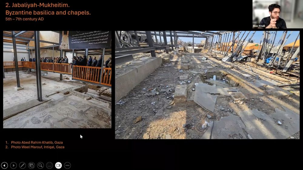
Help Gazan students to complete their university degrees
The war in Gaza has devastated the region’s higher education infrastructure. Several universities have been damaged or destroyed, forcing students to continue their studies online under extremely diff...
gogetfunding.com
Reposted by Michael Fradley

Reposted by Michael Fradley

