


OpenTopography
@opentopography.org
Open access to high-resolution, Earth science-oriented topography data, and related tools & resources. US National Science Foundation supported. #lidar https://www.opentopography.org
Check out the latest datasets now available on OpenTopography, which include over a dozen new USGS 3DEP datasets, new NOAA Coastal Lidar, and data collected over the Eaton Fire in Los Angeles, California.
opentopography.org/news/decembe...
opentopography.org/news/decembe...


January 12, 2026 at 5:43 PM
Check out the latest datasets now available on OpenTopography, which include over a dozen new USGS 3DEP datasets, new NOAA Coastal Lidar, and data collected over the Eaton Fire in Los Angeles, California.
opentopography.org/news/decembe...
opentopography.org/news/decembe...
Please join OpenTopo's Chelsea Scott & Cassandra Brigham for a WHPC@SDSC Professional Speaker Series talk.
Topographic change with OpenTopography: Adventures in cloud computing, spatial uncertainty, and impactful applications
Feb. 25, 2026 at 1–2 pm PT
Register: www.sdsc.edu/events/20260...
Topographic change with OpenTopography: Adventures in cloud computing, spatial uncertainty, and impactful applications
Feb. 25, 2026 at 1–2 pm PT
Register: www.sdsc.edu/events/20260...

January 7, 2026 at 8:06 PM
Please join OpenTopo's Chelsea Scott & Cassandra Brigham for a WHPC@SDSC Professional Speaker Series talk.
Topographic change with OpenTopography: Adventures in cloud computing, spatial uncertainty, and impactful applications
Feb. 25, 2026 at 1–2 pm PT
Register: www.sdsc.edu/events/20260...
Topographic change with OpenTopography: Adventures in cloud computing, spatial uncertainty, and impactful applications
Feb. 25, 2026 at 1–2 pm PT
Register: www.sdsc.edu/events/20260...
At #AGU25? Be sure to check out these presentations by OpenTopography team members!
OT at AGU: opentopography.org/news/opentop...
OT at AGU: opentopography.org/news/opentop...


December 16, 2025 at 5:28 PM
At #AGU25? Be sure to check out these presentations by OpenTopography team members!
OT at AGU: opentopography.org/news/opentop...
OT at AGU: opentopography.org/news/opentop...
November's new data releases on OpenTopography include a new Community Dataspace dataset and USGS 3DEP coverage in California, plus NOAA Coastal Lidar over Ohio.
Read more and access data: opentopography.org/news/novembe...
Read more and access data: opentopography.org/news/novembe...


December 10, 2025 at 5:02 PM
November's new data releases on OpenTopography include a new Community Dataspace dataset and USGS 3DEP coverage in California, plus NOAA Coastal Lidar over Ohio.
Read more and access data: opentopography.org/news/novembe...
Read more and access data: opentopography.org/news/novembe...
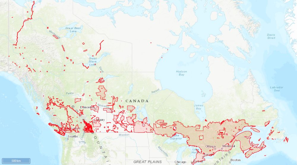
Final year for NSF-supported NCALM seed project proposals! Great opportunity for students to get free #lidar for research. Focus this year is projects in the Alaskan Arctic.
Data become open via OT. To date there are 252 NCALM datasets available on OT (red ⬇️)
Info: ncalm.cive.uh.edu/seed-proposals
Data become open via OT. To date there are 252 NCALM datasets available on OT (red ⬇️)
Info: ncalm.cive.uh.edu/seed-proposals

December 10, 2025 at 4:46 PM
Final year for NSF-supported NCALM seed project proposals! Great opportunity for students to get free #lidar for research. Focus this year is projects in the Alaskan Arctic.
Data become open via OT. To date there are 252 NCALM datasets available on OT (red ⬇️)
Info: ncalm.cive.uh.edu/seed-proposals
Data become open via OT. To date there are 252 NCALM datasets available on OT (red ⬇️)
Info: ncalm.cive.uh.edu/seed-proposals
Connect with OpenTopography at #AGU25 in New Orleans next week! Our booth (908) is staffed by the OT team and is a great chance to ask questions, provide feedback, or to discuss lidar, high resolution topography, and cyberinfrastructure.
opentopography.org/news/opentop...
opentopography.org/news/opentop...

December 9, 2025 at 3:02 PM
Connect with OpenTopography at #AGU25 in New Orleans next week! Our booth (908) is staffed by the OT team and is a great chance to ask questions, provide feedback, or to discuss lidar, high resolution topography, and cyberinfrastructure.
opentopography.org/news/opentop...
opentopography.org/news/opentop...
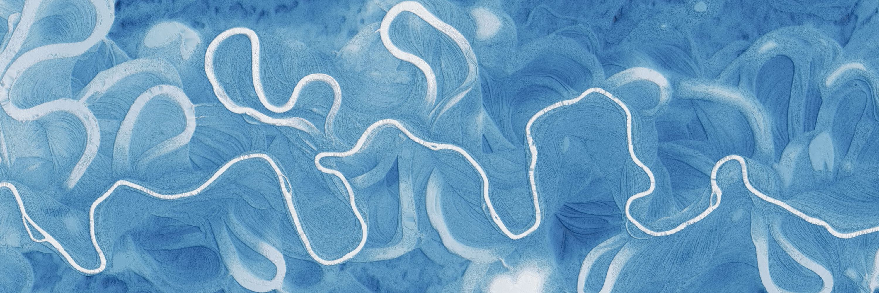
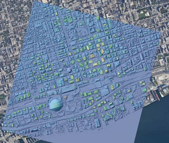
For the last several decades, scientists have been developing a way to make our maps more reliable with point cloud data collected by lidar. Lidar is an accurate method that helps scientists to map cities, landscapes, and places that were previously difficult or dangerous to access.
November 10, 2025 at 5:26 PM
For the last several decades, scientists have been developing a way to make our maps more reliable with point cloud data collected by lidar. Lidar is an accurate method that helps scientists to map cities, landscapes, and places that were previously difficult or dangerous to access.
New for educators! Lab Exercise: Using lidar to track Lake Michigan bluff retreat and inform local communities
Designed for community college and intro-level geomorph, enviro sci, and GIS courses, students use lidar data to learn about dynamic coastal erosion.
opentopography.org/learn/WI_blu...
Designed for community college and intro-level geomorph, enviro sci, and GIS courses, students use lidar data to learn about dynamic coastal erosion.
opentopography.org/learn/WI_blu...

November 3, 2025 at 10:22 PM
New for educators! Lab Exercise: Using lidar to track Lake Michigan bluff retreat and inform local communities
Designed for community college and intro-level geomorph, enviro sci, and GIS courses, students use lidar data to learn about dynamic coastal erosion.
opentopography.org/learn/WI_blu...
Designed for community college and intro-level geomorph, enviro sci, and GIS courses, students use lidar data to learn about dynamic coastal erosion.
opentopography.org/learn/WI_blu...
OT will be at GSA Connects 2025 in San Antonio, TX, Oct 19–22. Visit us at booth 809 to talk lidar, topography, and grab an "I ❤️ LIDAR" sticker. OT is honored to receive the 2025 GSA President’s Medal. Join us for the President’s Medal Lecture on Mon Oct. 20.
opentopography.org/news/opentop...
opentopography.org/news/opentop...

October 15, 2025 at 3:32 PM
OT will be at GSA Connects 2025 in San Antonio, TX, Oct 19–22. Visit us at booth 809 to talk lidar, topography, and grab an "I ❤️ LIDAR" sticker. OT is honored to receive the 2025 GSA President’s Medal. Join us for the President’s Medal Lecture on Mon Oct. 20.
opentopography.org/news/opentop...
opentopography.org/news/opentop...
New September 2025 data releases on OpenTopography include Land Information New Zealand (LINZ) lidar over the North Island of New Zealand, SfM topography over the 2019 Ridgecrest rupture, NOAA coastal lidar additions, and additional USGS 3DEP data.
opentopography.org/news/septemb...
opentopography.org/news/septemb...


October 2, 2025 at 5:44 PM
New September 2025 data releases on OpenTopography include Land Information New Zealand (LINZ) lidar over the North Island of New Zealand, SfM topography over the 2019 Ridgecrest rupture, NOAA coastal lidar additions, and additional USGS 3DEP data.
opentopography.org/news/septemb...
opentopography.org/news/septemb...
Coastlines in Crisis
Coastal areas like the Outer Banks of North Carolina are shrinking. What can we learn and see from lidar data?
Coastal areas like the Outer Banks of North Carolina are shrinking. What can we learn and see from lidar data?
October 1, 2025 at 5:19 PM
Coastlines in Crisis
Coastal areas like the Outer Banks of North Carolina are shrinking. What can we learn and see from lidar data?
Coastal areas like the Outer Banks of North Carolina are shrinking. What can we learn and see from lidar data?
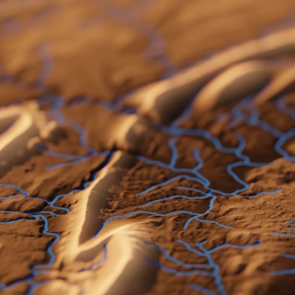
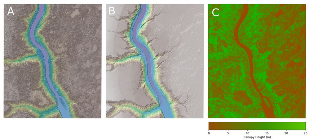
Check out TopoRivBlender, a new tool to create custom 3D images of topography and hydrography. Uses Blender and the OpenTopography API to produce 3D visualizations for data around the world.
More info:
waterdata.usgs.gov/blog/topo-ri...
github.com/DOI-USGS/top...
More info:
waterdata.usgs.gov/blog/topo-ri...
github.com/DOI-USGS/top...


September 29, 2025 at 5:54 PM
Check out TopoRivBlender, a new tool to create custom 3D images of topography and hydrography. Uses Blender and the OpenTopography API to produce 3D visualizations for data around the world.
More info:
waterdata.usgs.gov/blog/topo-ri...
github.com/DOI-USGS/top...
More info:
waterdata.usgs.gov/blog/topo-ri...
github.com/DOI-USGS/top...
Join OpenTopography's Chelsea Scott and Cassandra Brigham for an AGU EPSP Connects Virtual Science Talk on cloud computing, spatial uncertainty, and impactful applications of topographic change on September 17, 2025 at 11 am ET (8 am PT).
Register to attend: tinyurl.com/sep17epsptalk
Register to attend: tinyurl.com/sep17epsptalk

September 15, 2025 at 6:00 PM
Join OpenTopography's Chelsea Scott and Cassandra Brigham for an AGU EPSP Connects Virtual Science Talk on cloud computing, spatial uncertainty, and impactful applications of topographic change on September 17, 2025 at 11 am ET (8 am PT).
Register to attend: tinyurl.com/sep17epsptalk
Register to attend: tinyurl.com/sep17epsptalk
The stunning sandstone peaks of the Zhangjiajie National Forest Park in China inspired the floating mountains in the movie Avatar, but how did the real-life versions form?
September 11, 2025 at 6:27 PM
The stunning sandstone peaks of the Zhangjiajie National Forest Park in China inspired the floating mountains in the movie Avatar, but how did the real-life versions form?
OpenTopography datasets have been chosen for the NSF's National Artificial Intelligence Research Resource (NAIRR) Pilot Program, aiming to provide access to high-quality datasets that support the advancement of AI literacy, education, and innovation.
Read more ⬇️
opentopography.org/news/nsf-nairr
Read more ⬇️
opentopography.org/news/nsf-nairr

September 10, 2025 at 4:04 PM
OpenTopography datasets have been chosen for the NSF's National Artificial Intelligence Research Resource (NAIRR) Pilot Program, aiming to provide access to high-quality datasets that support the advancement of AI literacy, education, and innovation.
Read more ⬇️
opentopography.org/news/nsf-nairr
Read more ⬇️
opentopography.org/news/nsf-nairr
August's new data releases on OpenTopography include additional USGS 3DEP 1m raster updates (available to academics and OT+ subscribers), and UAV data from landslide reconnaissance monitoring in Utah.
Access the data: opentopography.org/news/august-...
Access the data: opentopography.org/news/august-...


September 9, 2025 at 6:42 PM
August's new data releases on OpenTopography include additional USGS 3DEP 1m raster updates (available to academics and OT+ subscribers), and UAV data from landslide reconnaissance monitoring in Utah.
Access the data: opentopography.org/news/august-...
Access the data: opentopography.org/news/august-...
The Martian Mega-Volcano
The tallest volcano on Earth, Hawaii's Mauna Kea, pales in comparison to Olympus Mons on Mars, the largest volcano in the solar system. See what we can learn by studying the topography of planetary bodies.
The tallest volcano on Earth, Hawaii's Mauna Kea, pales in comparison to Olympus Mons on Mars, the largest volcano in the solar system. See what we can learn by studying the topography of planetary bodies.
August 18, 2025 at 6:57 PM
The Martian Mega-Volcano
The tallest volcano on Earth, Hawaii's Mauna Kea, pales in comparison to Olympus Mons on Mars, the largest volcano in the solar system. See what we can learn by studying the topography of planetary bodies.
The tallest volcano on Earth, Hawaii's Mauna Kea, pales in comparison to Olympus Mons on Mars, the largest volcano in the solar system. See what we can learn by studying the topography of planetary bodies.
A number of new topographic datasets are now available on OpenTopography. July dataset additions include the High Resolution Digital Elevation Model of Canada, NOAA coastal lidar of the Indiana coastline, and new LINZ lidar over New Zealand.
opentopography.org/news/july-20...
opentopography.org/news/july-20...


August 13, 2025 at 3:09 PM
A number of new topographic datasets are now available on OpenTopography. July dataset additions include the High Resolution Digital Elevation Model of Canada, NOAA coastal lidar of the Indiana coastline, and new LINZ lidar over New Zealand.
opentopography.org/news/july-20...
opentopography.org/news/july-20...
How do you end up with desert dunes next to a wetland? The Potholes Reservoir explained.
August 6, 2025 at 4:04 PM
How do you end up with desert dunes next to a wetland? The Potholes Reservoir explained.
The Mystery of the Missoula Megafloods
What can we learn from the topography of the Pacific Northwest?
What can we learn from the topography of the Pacific Northwest?
August 4, 2025 at 6:11 PM
The Mystery of the Missoula Megafloods
What can we learn from the topography of the Pacific Northwest?
What can we learn from the topography of the Pacific Northwest?
6th largest #earthquake recorded by modern instruments. USGS epicentral location plotted on GEBCO Global Bathymetry & Topography dataset freely available from OpenTopography: doi.org/10.5069/G9D2.... Red line is the coastline of the Kamchatka Peninsula. Follow @earthscope.org for more on this event.

July 30, 2025 at 4:19 AM
6th largest #earthquake recorded by modern instruments. USGS epicentral location plotted on GEBCO Global Bathymetry & Topography dataset freely available from OpenTopography: doi.org/10.5069/G9D2.... Red line is the coastline of the Kamchatka Peninsula. Follow @earthscope.org for more on this event.
How did Devils Tower form?
July 28, 2025 at 5:58 PM
How did Devils Tower form?
OpenTopography is excited to announce a major expansion to its international data catalog with the addition of the High Resolution Digital Elevation Model from Natural Resources Canada. This 1-meter resolution dataset is ideal for a wide range of applications.
opentopography.org/news/opentop...
opentopography.org/news/opentop...
July 23, 2025 at 2:35 PM
OpenTopography is excited to announce a major expansion to its international data catalog with the addition of the High Resolution Digital Elevation Model from Natural Resources Canada. This 1-meter resolution dataset is ideal for a wide range of applications.
opentopography.org/news/opentop...
opentopography.org/news/opentop...
New topographic datasets are now available on OpenTopography! June additions include lidar over Mount Ruapehu (New Zealand), Point Beach State Forest (WI), and new NOAA coastal data from Florida and the Southeast U.S.
➡️ opentopography.org/news/june-20...
➡️ opentopography.org/news/june-20...


July 10, 2025 at 5:52 PM
New topographic datasets are now available on OpenTopography! June additions include lidar over Mount Ruapehu (New Zealand), Point Beach State Forest (WI), and new NOAA coastal data from Florida and the Southeast U.S.
➡️ opentopography.org/news/june-20...
➡️ opentopography.org/news/june-20...
OpenTopography is excited to introduce enhanced classification filtering options for lidar point cloud processing. Users can now selectively include or exclude specific point classes directly through the job submission interface, helping to streamline workflows.
opentopography.org/news/new-cla...
opentopography.org/news/new-cla...


May 27, 2025 at 4:11 PM
OpenTopography is excited to introduce enhanced classification filtering options for lidar point cloud processing. Users can now selectively include or exclude specific point classes directly through the job submission interface, helping to streamline workflows.
opentopography.org/news/new-cla...
opentopography.org/news/new-cla...