


Rob Lambert
@roblambert.bsky.social
Weather warrior and Operational Meteorologist. Conquering hurricanes, winter storms, and data. Embracing the outdoors, sports, and sharing personal opinions.
Loves it ☺️ hopefully we can expand the BlueSky usage for Wx info
December 4, 2025 at 6:00 PM
Loves it ☺️ hopefully we can expand the BlueSky usage for Wx info
@cyclone-fogarty.bsky.social yes I do, for some reason it didn’t get pinned on top of the Canadian one. Here is the link to the post I made about it:
bsky.app/profile/robl...
bsky.app/profile/robl...
I made another custom feed that is specific to Atlantic Canada. If you would like to appear on it, then use a hashtag with the province and either 'storm' or 'wx' at the end of it. E.g.: #NSstorm, #NLwx
Will all show up on the feed. I will add more if there's a desire.
bsky.app/profile/did:...
Will all show up on the feed. I will add more if there's a desire.
bsky.app/profile/did:...
December 4, 2025 at 5:17 PM
@cyclone-fogarty.bsky.social yes I do, for some reason it didn’t get pinned on top of the Canadian one. Here is the link to the post I made about it:
bsky.app/profile/robl...
bsky.app/profile/robl...
10pm update… rain continues, snow compact is really tight now. Still 0.75cm though on the board. It is almost at saturation, I’d expect that it will be gone within the next few hours. Unless I see another phase change, I will not be out again tonight to do an official update
#NSStorm #NSwx #Halisky
#NSStorm #NSwx #Halisky
December 3, 2025 at 2:06 AM
7pm update… after abit of a lull, I decided to take a core sample. From 2.25cm of snowfall (remeasured to be sure) I got 3.1mm of water. This is giving a ratio of 7.26:1
Walking in with my core sample, I was noticing freezing rain actively occurring.
#NSStorm #NSwx #Halisky
Walking in with my core sample, I was noticing freezing rain actively occurring.
#NSStorm #NSwx #Halisky
December 2, 2025 at 11:14 PM


4pm update… flurries have stopped giving us a bit of a lull, looking at radar (@wxwise.app) it looks like there’s a small pocket affecting us which will be filled in shortly.

December 2, 2025 at 8:09 PM
4pm update… flurries have stopped giving us a bit of a lull, looking at radar (@wxwise.app) it looks like there’s a small pocket affecting us which will be filled in shortly.


I know here in Canada a lot of observers will do a speci when a record temp is recorded.
Just nice to see the metar to see what other conditions are more easily.
Just nice to see the metar to see what other conditions are more easily.
April 17, 2025 at 7:39 PM
I know here in Canada a lot of observers will do a speci when a record temp is recorded.
Just nice to see the metar to see what other conditions are more easily.
Just nice to see the metar to see what other conditions are more easily.
SYNOPs are always awesome to see but I agree, most people don’t know what it says… but I think METAR is easier to understand for most people.
April 17, 2025 at 3:55 PM
SYNOPs are always awesome to see but I agree, most people don’t know what it says… but I think METAR is easier to understand for most people.
Would’ve been nice to capture a METAR showing this, but I got this screen cap off Windy.
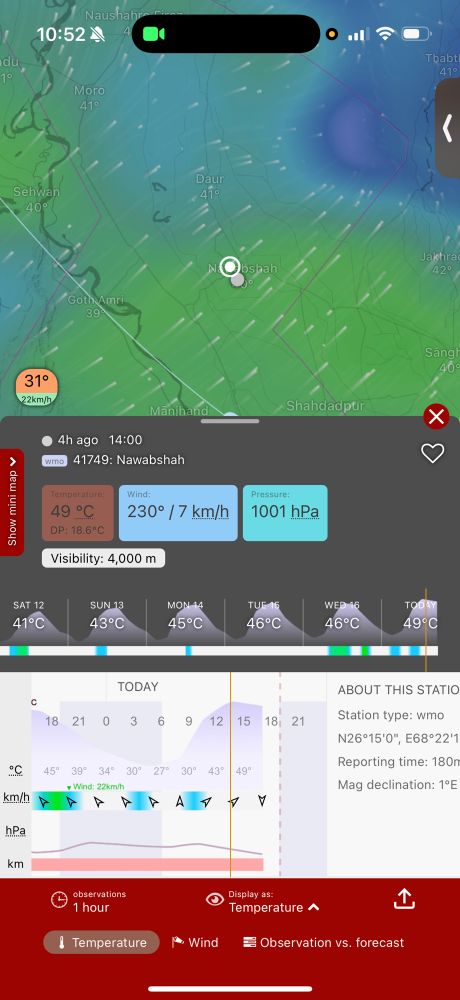
April 17, 2025 at 1:53 PM
Would’ve been nice to capture a METAR showing this, but I got this screen cap off Windy.