


Johnny K
@stormchaser4850.bsky.social
*Regardless of the method or source, you should ALWAYS STAY WEATHER AWARE as weather is ALWAYS changing*
(All weather, all the time)
TikTOK: https://www.tiktok.com/@alwaysstayweatheraware?lang=en
(All weather, all the time)
TikTOK: https://www.tiktok.com/@alwaysstayweatheraware?lang=en
( #NWSMarquette): Snowvember ended with a bang as a strong storm brought heavy snow to the UP through Thanksgiving. Our storm total of 26" pushed us into the TOP 3 SNOWIEST NOVEMBERS, only falling behind 1991 and 2014. #Marquette #Michigan #MIwx #wx #wxsky

December 2, 2025 at 7:58 PM
( #NWSMarquette): Snowvember ended with a bang as a strong storm brought heavy snow to the UP through Thanksgiving. Our storm total of 26" pushed us into the TOP 3 SNOWIEST NOVEMBERS, only falling behind 1991 and 2014. #Marquette #Michigan #MIwx #wx #wxsky
( #NWSPhoenix): Meteorological fall 2025 (Sep, Oct, Nov) is officially the wettest on record for #Phoenix Sky Harbor Airport as it registered 6.31" of rain. In fact, approximately 76% of the total annual rainfall recorded at Sky Harbor Airport so far has occurred since September 1st #AZwx #wx #wxsky

December 2, 2025 at 5:53 PM
( #NWSPhoenix): Meteorological fall 2025 (Sep, Oct, Nov) is officially the wettest on record for #Phoenix Sky Harbor Airport as it registered 6.31" of rain. In fact, approximately 76% of the total annual rainfall recorded at Sky Harbor Airport so far has occurred since September 1st #AZwx #wx #wxsky


December 2, 2025 at 12:21 PM
Note: ❄️Meteorological #WINTER❄️ starts off with the most widespread #SNOW-COVER of the season SO FAR at 33.4 PERCENT across the contiguous #UnitedStates ( #USwx ) as of early Monday morning (December 1) via ( #NOAA )

December 1, 2025 at 3:06 PM
Note: ❄️Meteorological #WINTER❄️ starts off with the most widespread #SNOW-COVER of the season SO FAR at 33.4 PERCENT across the contiguous #UnitedStates ( #USwx ) as of early Monday morning (December 1) via ( #NOAA )


December 1, 2025 at 12:20 PM
( #NWSWPC): Widespread hazardous travel is likely Monday night through Tuesday night (December 1-2) due to #snow & #ice especially during Tuesday commutes. HEAVY SNOW (5-10+") in the Northeast #USwx; significant icing (0.1-0.2") in the Appalachians. Stay safe & check www.weather.gov! #wx #wxsky

December 1, 2025 at 10:33 AM
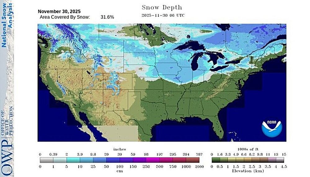
Note: #SNOW-COVER reported across 31.6 percent of the contiguous #UnitedStates ( #USwx ) as of early Sunday morning (November 30) via ( #NOAA ) after a significant early season #WinterSTORM on Saturday
❄️**This is the most widespread SNOW-COVER of the season so far**❄️
#wx #wxsky
❄️**This is the most widespread SNOW-COVER of the season so far**❄️
#wx #wxsky
November 30, 2025 at 1:59 PM
Note: #SNOW-COVER reported across 31.6 percent of the contiguous #UnitedStates ( #USwx ) as of early Sunday morning (November 30) via ( #NOAA ) after a significant early season #WinterSTORM on Saturday
❄️**This is the most widespread SNOW-COVER of the season so far**❄️
#wx #wxsky
❄️**This is the most widespread SNOW-COVER of the season so far**❄️
#wx #wxsky
( #NWSWPC): #WinterSTORM likely next week: Hazardous travel, #snow and #ice expected.
Low pressure tracking through the Mid-Atlantic & Northeast may bring significant snow of >6" N/W of I-95. Treacherous icing possible in the Appalachians. Stay updated! #USwx #wx #wxsky
Low pressure tracking through the Mid-Atlantic & Northeast may bring significant snow of >6" N/W of I-95. Treacherous icing possible in the Appalachians. Stay updated! #USwx #wx #wxsky

November 30, 2025 at 12:41 PM


November 30, 2025 at 12:23 PM
( #NWSduluth): Two Harbors looking nice and coated under that lake effect #snow band.
Report of 3" of new snow there as of ten minutes ago. #Minnesota #MNwx #wx #wxsky
Report of 3" of new snow there as of ten minutes ago. #Minnesota #MNwx #wx #wxsky
November 30, 2025 at 3:48 AM
( #NWSduluth): Two Harbors looking nice and coated under that lake effect #snow band.
Report of 3" of new snow there as of ten minutes ago. #Minnesota #MNwx #wx #wxsky
Report of 3" of new snow there as of ten minutes ago. #Minnesota #MNwx #wx #wxsky
Several reports of more than 1 FOOT of #snow reported across parts of #Iowa ( #IAwx ), north of #DesMoines from an ongoing significant early season #WinterSTORM as of late Saturday afternoon (November 29) #wx #wxsky

November 29, 2025 at 11:48 PM
Several reports of more than 1 FOOT of #snow reported across parts of #Iowa ( #IAwx ), north of #DesMoines from an ongoing significant early season #WinterSTORM as of late Saturday afternoon (November 29) #wx #wxsky
( #NWSWPC): The threat of a #WinterSTORM across the Mid-Atlantic into the Northeast #USwx continues to increase for early next week.
Some minor to potentially moderate travel impacts are possible for this event, so stay tuned for the latest information from WPC and your local forecast offices! #wx
Some minor to potentially moderate travel impacts are possible for this event, so stay tuned for the latest information from WPC and your local forecast offices! #wx

November 29, 2025 at 10:06 PM
( #NWSWPC): The threat of a #WinterSTORM across the Mid-Atlantic into the Northeast #USwx continues to increase for early next week.
Some minor to potentially moderate travel impacts are possible for this event, so stay tuned for the latest information from WPC and your local forecast offices! #wx
Some minor to potentially moderate travel impacts are possible for this event, so stay tuned for the latest information from WPC and your local forecast offices! #wx
Live: #Springfield #Illinois ( #ILwx ): www.wcia.com/springfield-...
Moderate to HEAVY #snow moving across the capital city of Springfield with ongoing significant early season #WinterSTORM early Saturday afternoon (November 29) #wx #wxsky
Moderate to HEAVY #snow moving across the capital city of Springfield with ongoing significant early season #WinterSTORM early Saturday afternoon (November 29) #wx #wxsky
November 29, 2025 at 7:55 PM
Live: #Springfield #Illinois ( #ILwx ): www.wcia.com/springfield-...
Moderate to HEAVY #snow moving across the capital city of Springfield with ongoing significant early season #WinterSTORM early Saturday afternoon (November 29) #wx #wxsky
Moderate to HEAVY #snow moving across the capital city of Springfield with ongoing significant early season #WinterSTORM early Saturday afternoon (November 29) #wx #wxsky
Live: #Chicago #Illinois ( #ILwx ) at Cloud Gate (The Bean): www.fox32chicago.com/weather-came...
Significant early season #WinterSTORM in progress across the Chicago area through late Saturday night (November 29) with up to 10 inches of #snow possible #wx #wxsky
Significant early season #WinterSTORM in progress across the Chicago area through late Saturday night (November 29) with up to 10 inches of #snow possible #wx #wxsky
November 29, 2025 at 5:23 PM
Live: #Chicago #Illinois ( #ILwx ) at Cloud Gate (The Bean): www.fox32chicago.com/weather-came...
Significant early season #WinterSTORM in progress across the Chicago area through late Saturday night (November 29) with up to 10 inches of #snow possible #wx #wxsky
Significant early season #WinterSTORM in progress across the Chicago area through late Saturday night (November 29) with up to 10 inches of #snow possible #wx #wxsky
Live: #DesMoines #Iowa ( #IAwx ): www.youtube.com/watch?v=XwHB...
Significant early season #WinterSTORM ongoing across Iowa including the capital city of Des Moines with moderate to heavy #snow being reported as of late Saturday morning (November 29) #wx #wxsky
Significant early season #WinterSTORM ongoing across Iowa including the capital city of Des Moines with moderate to heavy #snow being reported as of late Saturday morning (November 29) #wx #wxsky
November 29, 2025 at 4:41 PM
Live: #DesMoines #Iowa ( #IAwx ): www.youtube.com/watch?v=XwHB...
Significant early season #WinterSTORM ongoing across Iowa including the capital city of Des Moines with moderate to heavy #snow being reported as of late Saturday morning (November 29) #wx #wxsky
Significant early season #WinterSTORM ongoing across Iowa including the capital city of Des Moines with moderate to heavy #snow being reported as of late Saturday morning (November 29) #wx #wxsky


November 29, 2025 at 12:21 PM

Live: #DesMoines #Iowa ( #IAwx ): www.youtube.com/watch?v=XwHB...
Significant #WinterSTORM unfolding across the capital city of Des Moines with up to 1 FOOT of #snow possible through Saturday night (November 29) #wx #wxsky
Significant #WinterSTORM unfolding across the capital city of Des Moines with up to 1 FOOT of #snow possible through Saturday night (November 29) #wx #wxsky
November 29, 2025 at 6:32 AM
Live: #DesMoines #Iowa ( #IAwx ): www.youtube.com/watch?v=XwHB...
Significant #WinterSTORM unfolding across the capital city of Des Moines with up to 1 FOOT of #snow possible through Saturday night (November 29) #wx #wxsky
Significant #WinterSTORM unfolding across the capital city of Des Moines with up to 1 FOOT of #snow possible through Saturday night (November 29) #wx #wxsky
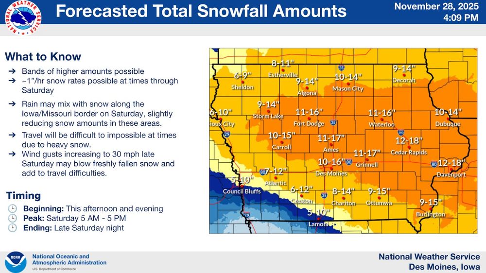
( #NWSDesMoines): HEAVY #SNOW expected through Sat night. Winds will increase Sat eve with gusts as high as 30 mph into Sunday leading to blowing and drifting snow. Travel will be difficult to impossible much of this weekend. Follow the latest forecast and consider altering travel plans. #IAwx #wx
November 29, 2025 at 12:35 AM
( #NWSDesMoines): HEAVY #SNOW expected through Sat night. Winds will increase Sat eve with gusts as high as 30 mph into Sunday leading to blowing and drifting snow. Travel will be difficult to impossible much of this weekend. Follow the latest forecast and consider altering travel plans. #IAwx #wx


November 28, 2025 at 12:21 PM
( #NWSWPC): A significant #WinterSTORM will bring widespread HEAVY #SNOW to much of the Midwest through this upcoming weekend.
HEAVY #SNOWFALL accumulating to 6-12"+ will create DANGEROUS travel for many areas, including #DesMoines, #Chicago, and #Milwaukee .⚠️ #IAwx #ILwx #WIwx #USwx #wx #wxsky
HEAVY #SNOWFALL accumulating to 6-12"+ will create DANGEROUS travel for many areas, including #DesMoines, #Chicago, and #Milwaukee .⚠️ #IAwx #ILwx #WIwx #USwx #wx #wxsky

November 28, 2025 at 12:02 PM
( #NWSWPC): A significant #WinterSTORM will bring widespread HEAVY #SNOW to much of the Midwest through this upcoming weekend.
HEAVY #SNOWFALL accumulating to 6-12"+ will create DANGEROUS travel for many areas, including #DesMoines, #Chicago, and #Milwaukee .⚠️ #IAwx #ILwx #WIwx #USwx #wx #wxsky
HEAVY #SNOWFALL accumulating to 6-12"+ will create DANGEROUS travel for many areas, including #DesMoines, #Chicago, and #Milwaukee .⚠️ #IAwx #ILwx #WIwx #USwx #wx #wxsky
Post- #Thanksgiving significant early season #WinterSTORM set to unfold on Friday (November 28) and through the weekend (November 29-30) across the Northern Plains into the #USwx Midwest
***Widespread Winter STORM watches, warnings and advisories in effect***
#wx #wxsky
***Widespread Winter STORM watches, warnings and advisories in effect***
#wx #wxsky
November 28, 2025 at 12:14 AM
Post- #Thanksgiving significant early season #WinterSTORM set to unfold on Friday (November 28) and through the weekend (November 29-30) across the Northern Plains into the #USwx Midwest
***Widespread Winter STORM watches, warnings and advisories in effect***
#wx #wxsky
***Widespread Winter STORM watches, warnings and advisories in effect***
#wx #wxsky

