


Johnny K
@stormchaser4850.bsky.social
*Regardless of the method or source, you should ALWAYS STAY WEATHER AWARE as weather is ALWAYS changing*
(All weather, all the time)
TikTOK: https://www.tiktok.com/@alwaysstayweatheraware?lang=en
(All weather, all the time)
TikTOK: https://www.tiktok.com/@alwaysstayweatheraware?lang=en
( #NWSMarquette): Snowvember ended with a bang as a strong storm brought heavy snow to the UP through Thanksgiving. Our storm total of 26" pushed us into the TOP 3 SNOWIEST NOVEMBERS, only falling behind 1991 and 2014. #Marquette #Michigan #MIwx #wx #wxsky

December 2, 2025 at 7:58 PM
( #NWSMarquette): Snowvember ended with a bang as a strong storm brought heavy snow to the UP through Thanksgiving. Our storm total of 26" pushed us into the TOP 3 SNOWIEST NOVEMBERS, only falling behind 1991 and 2014. #Marquette #Michigan #MIwx #wx #wxsky
Reposted by Johnny K

A storm system will bring accumulating snow tonight through Thursday morning for portions of Colorado, New Mexico, and Wyoming. Travel impacts are expected, so stay ahead of the storm by visiting weather.gov for details in your neck of the woods.

December 2, 2025 at 5:10 PM
A storm system will bring accumulating snow tonight through Thursday morning for portions of Colorado, New Mexico, and Wyoming. Travel impacts are expected, so stay ahead of the storm by visiting weather.gov for details in your neck of the woods.
Reposted by Johnny K

All aboard the Polar Express!! The tropospheric polar vortex will deliver frigid blasts in the eastern/ northern US for the next ~2 weeks and several chances of #snow. #cold #winter #fyp #polarexpress #polarvortex
December 2, 2025 at 5:28 PM
All aboard the Polar Express!! The tropospheric polar vortex will deliver frigid blasts in the eastern/ northern US for the next ~2 weeks and several chances of #snow. #cold #winter #fyp #polarexpress #polarvortex
( #NWSPhoenix): Meteorological fall 2025 (Sep, Oct, Nov) is officially the wettest on record for #Phoenix Sky Harbor Airport as it registered 6.31" of rain. In fact, approximately 76% of the total annual rainfall recorded at Sky Harbor Airport so far has occurred since September 1st #AZwx #wx #wxsky

December 2, 2025 at 5:53 PM
( #NWSPhoenix): Meteorological fall 2025 (Sep, Oct, Nov) is officially the wettest on record for #Phoenix Sky Harbor Airport as it registered 6.31" of rain. In fact, approximately 76% of the total annual rainfall recorded at Sky Harbor Airport so far has occurred since September 1st #AZwx #wx #wxsky


December 2, 2025 at 12:21 PM
Reposted by Johnny K

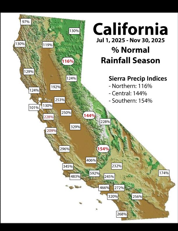
Percent of normal for the season to date from ggweather.com/seasonal_rai...
December 1, 2025 at 3:42 PM
Percent of normal for the season to date from ggweather.com/seasonal_rai...
Reposted by Johnny K

Boston has officially taken hold of the 2nd longest streak on record without a 6" snowfall
It won't snap this week, but interior areas of New England will pass that mark. Looking at tomorrow's snow on #wbz this evening
It won't snap this week, but interior areas of New England will pass that mark. Looking at tomorrow's snow on #wbz this evening

December 1, 2025 at 9:03 PM
Boston has officially taken hold of the 2nd longest streak on record without a 6" snowfall
It won't snap this week, but interior areas of New England will pass that mark. Looking at tomorrow's snow on #wbz this evening
It won't snap this week, but interior areas of New England will pass that mark. Looking at tomorrow's snow on #wbz this evening
Reposted by Johnny K

Map showing the coldest season of the year.

December 1, 2025 at 5:06 PM
Map showing the coldest season of the year.
Reposted by Johnny K

Grab the hot cocoa! ❄️ Today marks the beginning of meteorological winter, running from December through February. Unlike astronomical seasons determined by the rotation of Earth around the Sun and marked by equinoxes and solstices, meteorological seasons are based on the annual temperature cycle.

December 1, 2025 at 5:09 PM
Grab the hot cocoa! ❄️ Today marks the beginning of meteorological winter, running from December through February. Unlike astronomical seasons determined by the rotation of Earth around the Sun and marked by equinoxes and solstices, meteorological seasons are based on the annual temperature cycle.
Reposted by Johnny K

Its a MESS in KC right now!

December 1, 2025 at 5:17 PM
Its a MESS in KC right now!
Note: ❄️Meteorological #WINTER❄️ starts off with the most widespread #SNOW-COVER of the season SO FAR at 33.4 PERCENT across the contiguous #UnitedStates ( #USwx ) as of early Monday morning (December 1) via ( #NOAA )

December 1, 2025 at 3:06 PM
Note: ❄️Meteorological #WINTER❄️ starts off with the most widespread #SNOW-COVER of the season SO FAR at 33.4 PERCENT across the contiguous #UnitedStates ( #USwx ) as of early Monday morning (December 1) via ( #NOAA )
Reposted by Johnny K

Happy 1st day of meteorological winter ! Meteorologists use the seasons and not the solstice/equniox ? When you hear “hottest summer” or “coldest winter” these are based on meteorological seasons and not the customs of the solstice and equniox.


December 1, 2025 at 6:18 AM
Happy 1st day of meteorological winter ! Meteorologists use the seasons and not the solstice/equniox ? When you hear “hottest summer” or “coldest winter” these are based on meteorological seasons and not the customs of the solstice and equniox.
Reposted by Johnny K

Meteorological winter runs December through February to give a consistent, temperature-based way to track the coldest stretch of the year. #WinterStartsNow

December 1, 2025 at 12:10 PM
Meteorological winter runs December through February to give a consistent, temperature-based way to track the coldest stretch of the year. #WinterStartsNow


December 1, 2025 at 12:20 PM
( #NWSWPC): Widespread hazardous travel is likely Monday night through Tuesday night (December 1-2) due to #snow & #ice especially during Tuesday commutes. HEAVY SNOW (5-10+") in the Northeast #USwx; significant icing (0.1-0.2") in the Appalachians. Stay safe & check www.weather.gov! #wx #wxsky

December 1, 2025 at 10:33 AM
Reposted by Johnny K

Earliest sunsets are almost here. In early to mid-December, evenings become brighter again—no “Daylight Saving Time” needed!

November 29, 2025 at 8:02 PM
Earliest sunsets are almost here. In early to mid-December, evenings become brighter again—no “Daylight Saving Time” needed!
Reposted by Johnny K

NEW RECORD! Yesterday was Madison's snowiest November day on record with a total of 9.3" recorded at the airport. This surpasses the old record, set back in 1995, by nearly 2". #wiwx

November 30, 2025 at 3:18 PM
NEW RECORD! Yesterday was Madison's snowiest November day on record with a total of 9.3" recorded at the airport. This surpasses the old record, set back in 1995, by nearly 2". #wiwx
Reposted by Johnny K

The 2025 Atlantic #hurricane season ends today. 13 named storms, 5 hurricanes, & 4 major: a near-normal season. Three Cat 5 storms: Erin, Humberto, & #Melissa. Melissa producing a world record wind gust (252mph). No hurricanes made landfall in the US for the 1st time since 2015. #wx

November 30, 2025 at 3:21 PM
The 2025 Atlantic #hurricane season ends today. 13 named storms, 5 hurricanes, & 4 major: a near-normal season. Three Cat 5 storms: Erin, Humberto, & #Melissa. Melissa producing a world record wind gust (252mph). No hurricanes made landfall in the US for the 1st time since 2015. #wx
Reposted by Johnny K

The 2025 Atlantic Hurricane Season officially ends today. Overall, it was a slightly above-average season with some strange characteristics.
[1/4]
[1/4]

Summary of the Unusual 2025 Hurricane Season
Updates and summaries on tropical Atlantic activity... including easterly waves, tropical storms, subtropical storms, and hurricanes.
bmcnoldy.blogspot.com
November 30, 2025 at 1:12 PM
The 2025 Atlantic Hurricane Season officially ends today. Overall, it was a slightly above-average season with some strange characteristics.
[1/4]
[1/4]
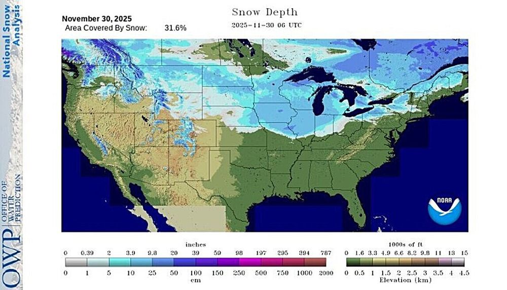
Note: #SNOW-COVER reported across 31.6 percent of the contiguous #UnitedStates ( #USwx ) as of early Sunday morning (November 30) via ( #NOAA ) after a significant early season #WinterSTORM on Saturday
❄️**This is the most widespread SNOW-COVER of the season so far**❄️
#wx #wxsky
❄️**This is the most widespread SNOW-COVER of the season so far**❄️
#wx #wxsky
November 30, 2025 at 1:59 PM
Note: #SNOW-COVER reported across 31.6 percent of the contiguous #UnitedStates ( #USwx ) as of early Sunday morning (November 30) via ( #NOAA ) after a significant early season #WinterSTORM on Saturday
❄️**This is the most widespread SNOW-COVER of the season so far**❄️
#wx #wxsky
❄️**This is the most widespread SNOW-COVER of the season so far**❄️
#wx #wxsky
Reposted by Johnny K

11/30: Today is the last day of the 2025 hurricane season. The month of November has proven to be very quiet this year, with no named storms during the month. There weren't even any disturbances mentioned in the Tropical Weather Outlook the en... https://x.com/NHC_Atlantic/status/1995096242884358356

November 30, 2025 at 11:44 AM
11/30: Today is the last day of the 2025 hurricane season. The month of November has proven to be very quiet this year, with no named storms during the month. There weren't even any disturbances mentioned in the Tropical Weather Outlook the en... https://x.com/NHC_Atlantic/status/1995096242884358356
( #NWSWPC): #WinterSTORM likely next week: Hazardous travel, #snow and #ice expected.
Low pressure tracking through the Mid-Atlantic & Northeast may bring significant snow of >6" N/W of I-95. Treacherous icing possible in the Appalachians. Stay updated! #USwx #wx #wxsky
Low pressure tracking through the Mid-Atlantic & Northeast may bring significant snow of >6" N/W of I-95. Treacherous icing possible in the Appalachians. Stay updated! #USwx #wx #wxsky

November 30, 2025 at 12:41 PM


November 30, 2025 at 12:23 PM
( #NWSduluth): Two Harbors looking nice and coated under that lake effect #snow band.
Report of 3" of new snow there as of ten minutes ago. #Minnesota #MNwx #wx #wxsky
Report of 3" of new snow there as of ten minutes ago. #Minnesota #MNwx #wx #wxsky
November 30, 2025 at 3:48 AM
( #NWSduluth): Two Harbors looking nice and coated under that lake effect #snow band.
Report of 3" of new snow there as of ten minutes ago. #Minnesota #MNwx #wx #wxsky
Report of 3" of new snow there as of ten minutes ago. #Minnesota #MNwx #wx #wxsky