


Johnny K
@stormchaser4850.bsky.social
*Regardless of the method or source, you should ALWAYS STAY WEATHER AWARE as weather is ALWAYS changing*
(All weather, all the time)
TikTOK: https://www.tiktok.com/@alwaysstayweatheraware?lang=en
(All weather, all the time)
TikTOK: https://www.tiktok.com/@alwaysstayweatheraware?lang=en
( #NWSWPC): RECORD #COLD is possible over the next few days across the Midwest, Ohio Valley, and Mid-Atlantic.
Lows are forecast to drop BELOW ZERO across parts of the Midwest tomorrow morning (12/4). Be sure to dress appropriately to avoid the risk of frostbite/hypothermia #USwx #wx #wxsky
Lows are forecast to drop BELOW ZERO across parts of the Midwest tomorrow morning (12/4). Be sure to dress appropriately to avoid the risk of frostbite/hypothermia #USwx #wx #wxsky


December 3, 2025 at 10:03 PM
Reposted by Johnny K

To get you in the Holiday Spirit!

December 3, 2025 at 9:42 PM
To get you in the Holiday Spirit!
( #NWSWPC): WPC has initiated Key Messages due to the potential for snow squalls along a strong arctic cold front tomorrow (Thursday). Snow squalls can result in a rapid drop in visibility and create icy roads very quickly, which can be hazardous to motorists. ❄️ #USwx #wx #wxsky

December 3, 2025 at 6:29 PM
Reposted by Johnny K

Precipitation over the next week looks to focus across the Pac NW and Gulf Coast regions with a decent soaking for each, along with lake effect precipitation falling downwind of the Great Lakes. What's in store for you? Check it out at weather.gov

December 3, 2025 at 4:26 PM
Precipitation over the next week looks to focus across the Pac NW and Gulf Coast regions with a decent soaking for each, along with lake effect precipitation falling downwind of the Great Lakes. What's in store for you? Check it out at weather.gov
Reposted by Johnny K

Highest snow amounts by state for yesterday's storm:
Cross Village, MI: 15.0"
Freedom, NH: 12.6"
Anson, ME: 12.0"
Ulster Co., NY: 12.0"
Bennington, VT: 11.5"...
Cross Village, MI: 15.0"
Freedom, NH: 12.6"
Anson, ME: 12.0"
Ulster Co., NY: 12.0"
Bennington, VT: 11.5"...

December 3, 2025 at 2:49 PM
Highest snow amounts by state for yesterday's storm:
Cross Village, MI: 15.0"
Freedom, NH: 12.6"
Anson, ME: 12.0"
Ulster Co., NY: 12.0"
Bennington, VT: 11.5"...
Cross Village, MI: 15.0"
Freedom, NH: 12.6"
Anson, ME: 12.0"
Ulster Co., NY: 12.0"
Bennington, VT: 11.5"...
Note: Early season #SNOW-COVER across the contiguous #UnitedStates expands to 40.3% as of early Wednesday (December 3)
❄️The MOST WIDESPREAD SNOW-COVER of the season SO FAR❄️
❄️The MOST WIDESPREAD SNOW-COVER for this date (December 3) in 6 years/since 2019 at 45.4%❄️
#USwx #wx #wxsky
❄️The MOST WIDESPREAD SNOW-COVER of the season SO FAR❄️
❄️The MOST WIDESPREAD SNOW-COVER for this date (December 3) in 6 years/since 2019 at 45.4%❄️
#USwx #wx #wxsky

December 3, 2025 at 1:30 PM
Note: Early season #SNOW-COVER across the contiguous #UnitedStates expands to 40.3% as of early Wednesday (December 3)
❄️The MOST WIDESPREAD SNOW-COVER of the season SO FAR❄️
❄️The MOST WIDESPREAD SNOW-COVER for this date (December 3) in 6 years/since 2019 at 45.4%❄️
#USwx #wx #wxsky
❄️The MOST WIDESPREAD SNOW-COVER of the season SO FAR❄️
❄️The MOST WIDESPREAD SNOW-COVER for this date (December 3) in 6 years/since 2019 at 45.4%❄️
#USwx #wx #wxsky


December 3, 2025 at 12:20 PM
Reposted by Johnny K

We can only go up from here ! Today marks the earliest sunset of the year for NYC. We’ll see sunset start to get later on December 13th.


December 3, 2025 at 7:01 AM
We can only go up from here ! Today marks the earliest sunset of the year for NYC. We’ll see sunset start to get later on December 13th.
( #NWSMarquette): Snowvember ended with a bang as a strong storm brought heavy snow to the UP through Thanksgiving. Our storm total of 26" pushed us into the TOP 3 SNOWIEST NOVEMBERS, only falling behind 1991 and 2014. #Marquette #Michigan #MIwx #wx #wxsky

December 2, 2025 at 7:58 PM
( #NWSMarquette): Snowvember ended with a bang as a strong storm brought heavy snow to the UP through Thanksgiving. Our storm total of 26" pushed us into the TOP 3 SNOWIEST NOVEMBERS, only falling behind 1991 and 2014. #Marquette #Michigan #MIwx #wx #wxsky
Reposted by Johnny K
A storm system will bring accumulating snow tonight through Thursday morning for portions of Colorado, New Mexico, and Wyoming. Travel impacts are expected, so stay ahead of the storm by visiting weather.gov for details in your neck of the woods.

December 2, 2025 at 5:10 PM
A storm system will bring accumulating snow tonight through Thursday morning for portions of Colorado, New Mexico, and Wyoming. Travel impacts are expected, so stay ahead of the storm by visiting weather.gov for details in your neck of the woods.
Reposted by Johnny K

All aboard the Polar Express!! The tropospheric polar vortex will deliver frigid blasts in the eastern/ northern US for the next ~2 weeks and several chances of #snow. #cold #winter #fyp #polarexpress #polarvortex
December 2, 2025 at 5:28 PM
All aboard the Polar Express!! The tropospheric polar vortex will deliver frigid blasts in the eastern/ northern US for the next ~2 weeks and several chances of #snow. #cold #winter #fyp #polarexpress #polarvortex
( #NWSPhoenix): Meteorological fall 2025 (Sep, Oct, Nov) is officially the wettest on record for #Phoenix Sky Harbor Airport as it registered 6.31" of rain. In fact, approximately 76% of the total annual rainfall recorded at Sky Harbor Airport so far has occurred since September 1st #AZwx #wx #wxsky

December 2, 2025 at 5:53 PM
( #NWSPhoenix): Meteorological fall 2025 (Sep, Oct, Nov) is officially the wettest on record for #Phoenix Sky Harbor Airport as it registered 6.31" of rain. In fact, approximately 76% of the total annual rainfall recorded at Sky Harbor Airport so far has occurred since September 1st #AZwx #wx #wxsky


December 2, 2025 at 12:21 PM
Reposted by Johnny K
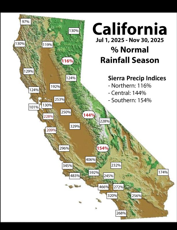
Percent of normal for the season to date from ggweather.com/seasonal_rai...
December 1, 2025 at 3:42 PM
Percent of normal for the season to date from ggweather.com/seasonal_rai...
Reposted by Johnny K

Boston has officially taken hold of the 2nd longest streak on record without a 6" snowfall
It won't snap this week, but interior areas of New England will pass that mark. Looking at tomorrow's snow on #wbz this evening
It won't snap this week, but interior areas of New England will pass that mark. Looking at tomorrow's snow on #wbz this evening

December 1, 2025 at 9:03 PM
Boston has officially taken hold of the 2nd longest streak on record without a 6" snowfall
It won't snap this week, but interior areas of New England will pass that mark. Looking at tomorrow's snow on #wbz this evening
It won't snap this week, but interior areas of New England will pass that mark. Looking at tomorrow's snow on #wbz this evening
Reposted by Johnny K

Map showing the coldest season of the year.

December 1, 2025 at 5:06 PM
Map showing the coldest season of the year.
Reposted by Johnny K

Grab the hot cocoa! ❄️ Today marks the beginning of meteorological winter, running from December through February. Unlike astronomical seasons determined by the rotation of Earth around the Sun and marked by equinoxes and solstices, meteorological seasons are based on the annual temperature cycle.

December 1, 2025 at 5:09 PM
Grab the hot cocoa! ❄️ Today marks the beginning of meteorological winter, running from December through February. Unlike astronomical seasons determined by the rotation of Earth around the Sun and marked by equinoxes and solstices, meteorological seasons are based on the annual temperature cycle.
Reposted by Johnny K

Its a MESS in KC right now!

December 1, 2025 at 5:17 PM
Its a MESS in KC right now!
Note: ❄️Meteorological #WINTER❄️ starts off with the most widespread #SNOW-COVER of the season SO FAR at 33.4 PERCENT across the contiguous #UnitedStates ( #USwx ) as of early Monday morning (December 1) via ( #NOAA )

December 1, 2025 at 3:06 PM
Note: ❄️Meteorological #WINTER❄️ starts off with the most widespread #SNOW-COVER of the season SO FAR at 33.4 PERCENT across the contiguous #UnitedStates ( #USwx ) as of early Monday morning (December 1) via ( #NOAA )
Reposted by Johnny K
Happy 1st day of meteorological winter ! Meteorologists use the seasons and not the solstice/equniox ? When you hear “hottest summer” or “coldest winter” these are based on meteorological seasons and not the customs of the solstice and equniox.


December 1, 2025 at 6:18 AM
Happy 1st day of meteorological winter ! Meteorologists use the seasons and not the solstice/equniox ? When you hear “hottest summer” or “coldest winter” these are based on meteorological seasons and not the customs of the solstice and equniox.
Reposted by Johnny K

Meteorological winter runs December through February to give a consistent, temperature-based way to track the coldest stretch of the year. #WinterStartsNow

December 1, 2025 at 12:10 PM
Meteorological winter runs December through February to give a consistent, temperature-based way to track the coldest stretch of the year. #WinterStartsNow


December 1, 2025 at 12:20 PM
( #NWSWPC): Widespread hazardous travel is likely Monday night through Tuesday night (December 1-2) due to #snow & #ice especially during Tuesday commutes. HEAVY SNOW (5-10+") in the Northeast #USwx; significant icing (0.1-0.2") in the Appalachians. Stay safe & check www.weather.gov! #wx #wxsky

December 1, 2025 at 10:33 AM
Reposted by Johnny K
Earliest sunsets are almost here. In early to mid-December, evenings become brighter again—no “Daylight Saving Time” needed!

November 29, 2025 at 8:02 PM
Earliest sunsets are almost here. In early to mid-December, evenings become brighter again—no “Daylight Saving Time” needed!