Dr. Kim Hannula
@stressrelated.bsky.social
860 followers 420 following 1.1K posts
Retired structural geology professor and geoscience education researcher, living in the mountains. Fan of blueschists, contact metamorphism, shear zones, faults, deformation bands, spatial thinking, strategies to make teaching more inclusive. She/her/hers
Posts Media Videos Starter Packs
Reposted by Dr. Kim Hannula
napaaqtuk.bsky.social
Another "storm of the century" is hitting Kotzebue, for the second year in a row. Last year's storm almost took out my dad's house. Woke up to videos of the flooding and it's already bad. They are expected to get another storm after this one passes.

www.kotz.org/kotz-local-n...
Kotzebue has issued a mandatory evacuation order as flooding from coastal storm begins
Water could rise as much as 10 feet above the high tide line, according the National Weather Service
www.kotz.org
stressrelated.bsky.social
Oh, no. Kotzebue.
alaskapublic.org
The city of Kotzebue is under mandatory evacuation orders. That's as the community prepares for flooding the National Weather Service warns could be worse than last year's, which led to dozens of evacuations and two families losing their homes.
Mandatory evacuations ordered in Kotzebue as flooding from coastal storm begins
Water could rise as much as 10 feet above the high tide line, according the National Weather Service.
akpub.io
stressrelated.bsky.social
I mean, it's not like he was flying along the San Andreas or past the Cascades...
stressrelated.bsky.social
Butter.

(I grew up in Maine.)
merriam-webster.com
What’s the word where you’re from that, when pronounced exactly as it looks, identifies a tourist immediately?
Reposted by Dr. Kim Hannula
kellyhereid.bsky.social
Sheesh - a tsunami big enough to push coral boulders 100s of m inland in the British Virgin Islands around the year 1400, likely sourced from an earthquake on the Puerto Rico Trench.
Reposted by Dr. Kim Hannula
minouette.bsky.social
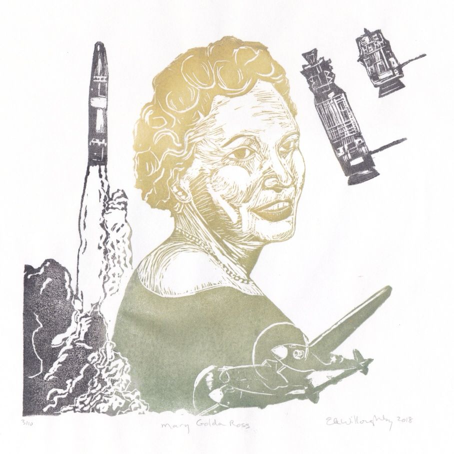
For #spacetober_challenge day 8 prompt propulsion, my portrait of #mathematician, aeronautical #engineer, philanthropist & Cherokee ‘hidden figure’ of the space race: Mary Golda Ross (1908-2008).⁠ 🧪🐡🧮🔭👩🏻‍🔬 #histsci

Great-great-granddaughter of Chief John Ross, who was forced to lead his people on the
Linocut portrait of Mary Golda Ross looking over her shoulder in a gradient of green (at bottom) to gold (at top) surrounded by vehicles important to her career including P-38 Lighting fighter plane, and Agena rocket, important to Apollo missions in grey.
Reposted by Dr. Kim Hannula
volcanojenni.bsky.social
We’re advertising a PhD studentship for folks with good knowledge of Caribbean culture and society, with background in geography, human geography, humanities or interdisciplinary geosciences as part of our @leverhulme.ac.uk funded ‘volcanic histories’ project
Summary of what the PhD student will do. QR code in bottom LHS. Project part of our Leverhulme Trust funded project volcanic histories and the student will examine the cultural markers and response to to volcanic activity across the Eastern Caribbean. Understand local ways of knowing and remembering volcanic activity. Integrate scientific. And community knowledge for DRR - joining an interdisciplinary team from several universities.
Reposted by Dr. Kim Hannula
squawky.bsky.social
You do not need to register for GSA to attend this workshop virtually - please check it out!
accessiblegeo.bsky.social
This #GSA #ShortCourse is accepting new virtual participants through Friday of this week (Oct 10). Be sure to secure your spot if interested! ♿
accessiblegeo.bsky.social
Geo-professionals with disabilities will be leading a short course at GSA Connects this year about the experiences of people with disabilities in the geoscience workforce.

Can’t get to San Antonio? You can attend virtually! Learn more and register at store.geosociety.org/products/sc2...
stressrelated.bsky.social
At the 2019 reunion presentation about the geothermal heat pump, the presenter mentioned something about the geo department getting excited and wanting to collect data. I love that the data became senior theses and then advice for other colleges.
stressrelated.bsky.social
Long-Term Monitoring of a Campus-
Scale Geothermal Heat Pump System
Using Distributed Temperature Sensing

(Fun to see the Bald Spot @carleton.edu on the cover of GSA Today! This is the best kind of news to get about one's alma mater.)

rock.geosociety.org/net/gsatoday...
rock.geosociety.org
Reposted by Dr. Kim Hannula
cires.colorado.edu
A storm and fall colors in Colorado — a CIRES scientist snapped this photo of the San Juan mountains from Last Dollar Road near Telluride. #PhotoFriday

📸: Christina Kumler @purpal9.bsky.social / CIRES
Storm clouds loom over high mountains sprinkled with snow. Orange, yellow, and green trees fills the landscape beneath the mountains.
stressrelated.bsky.social
It's going to take me extra reviewing time to make sure there isn't AI-generated garbage. Right now, I will have more trust for papers in slower-to-publish journals.
bipedalmeatbag.bsky.social
If journals want me to give a shit about their time to publication metric, they can pay my ass to edit/review and offer an incentive to publish with them. People who get my effort for free don’t get to make demands on timeliness.
Reposted by Dr. Kim Hannula
emd.wa.gov
We're just 😱 2 weeks away 😱 from the Great Washington #ShakeOut. Looking for ways to shake up your ShakeOut game? Check out our bingo card for some good ideas and see if you can get a full house!

And don't forget to register at shakeout.org/washington/ to help us hit 1.7 million participants!
A Great Washington Shake Out bingo card. The free space is drop, cover, and hold on. Other spaces are filled with suggested activities such as telling a friend about shake out, registering for shake out, testing your evacuation plan, signing up for local emergency alerts, and learning about local hazards.
Reposted by Dr. Kim Hannula
agu-h3s.bsky.social
CATCHMENT CUP IS LIVE! Whose ready to learn about some new (and old) research catchments?!? First up: HEADWATER CATCHMENTS

VOTE HERE until 10/4: www.agu-h3s.org/rivercup
stressrelated.bsky.social
Are you a Cocorahs site? That looks kind of like one of their gauges.
Reposted by Dr. Kim Hannula
glacierpique.bsky.social
I’m voting for the indicator mineral #Kyanite and the information it provides about metamorphic temperature and pressure, shown here with its pseudomorphs, Sillimanite and Andalusite.
#MinCup25
Image of a knife-sized blade of Kyanite next to a faceted Kyanite gemstone from mindat’s “Best of “ article, copyright Tony H Gill. Cruciform Andalusite crystals in a brown rock. Image from Wikipedia. Elongate Sillimanite crystals have square cross sections. Image from mindat.org. Copyright F. Kruijen & G. Blass
stressrelated.bsky.social
My other suggestion is to build more complex maps in gradually, and do a topo map exercise separately. There are some good suggestions in Journal of Geoscience Ed papers. I think from Heather Petcovic's research group?
stressrelated.bsky.social
I just read down, and with 44 students they would probably end up following the crowd. But maybe, hmmm, 11 different sets of points, and groups of four working together on a map?
stressrelated.bsky.social
Yes! For first-years (or new transfer students) you could use the questions to help them find useful places on campus (tutoring, financial aid, cultural centers, library...). Or reinforce whatever observations of nature you are making in class. Or leave it open-ended to encourage broad observation.
stressrelated.bsky.social
I would ask students to describe what they found at each spot. If they didn't have a lot of background in botany or geology or whatever, I would prepare myself to go back to the sites while grading to see if what they described made sense.
stressrelated.bsky.social
I'm guessing that starting with a map and finding things would be most appropriate. If I made one, I would find a handful (like four or five) places on campus (shrubs or boulders?), mark their location on a campus map, and stick small flags by them so students would know they found them.
stressrelated.bsky.social
What tools do you want them to use? Just a paper map, or a map and compass, or a map and GPS? And do you want them to start with a map and find things, or plot things that they find on a map?
Reposted by Dr. Kim Hannula
volts.wtf
This is amazing: @ladwp.com, the Los Angeles utility, has launched a program that will install solar+battery systems on qualifying low-to-moderate-income households, *for free*.

Yes: free.

If you know someone eligible, tell them to apply!
Self-Generation Incentive Program
The Self-Generation Incentive Program (SGIP) helps qualified LADWP residential customers install solar and battery storage systems by providing financial incentives. This program supports clean energy...
www.ladwp.com