Tom Coulthard
@tomcoulthard.bsky.social
930 followers
520 following
220 posts
Geomorphology - Modelling - non linear earth surface systems. Prof at Manchester Met, creator/curator of CAESAR-lisflood LEM, editor at Earth Surface Dynamics. Occasionally some 🛹 & 🧗♀️ content 😀
Posts
Media
Videos
Starter Packs
Pinned

Tom Coulthard
@tomcoulthard.bsky.social
· Jun 18

Tom Coulthard
@tomcoulthard.bsky.social
· Aug 23
Tom Coulthard
@tomcoulthard.bsky.social
· Aug 23


Reposted by Tom Coulthard


Reposted by Tom Coulthard


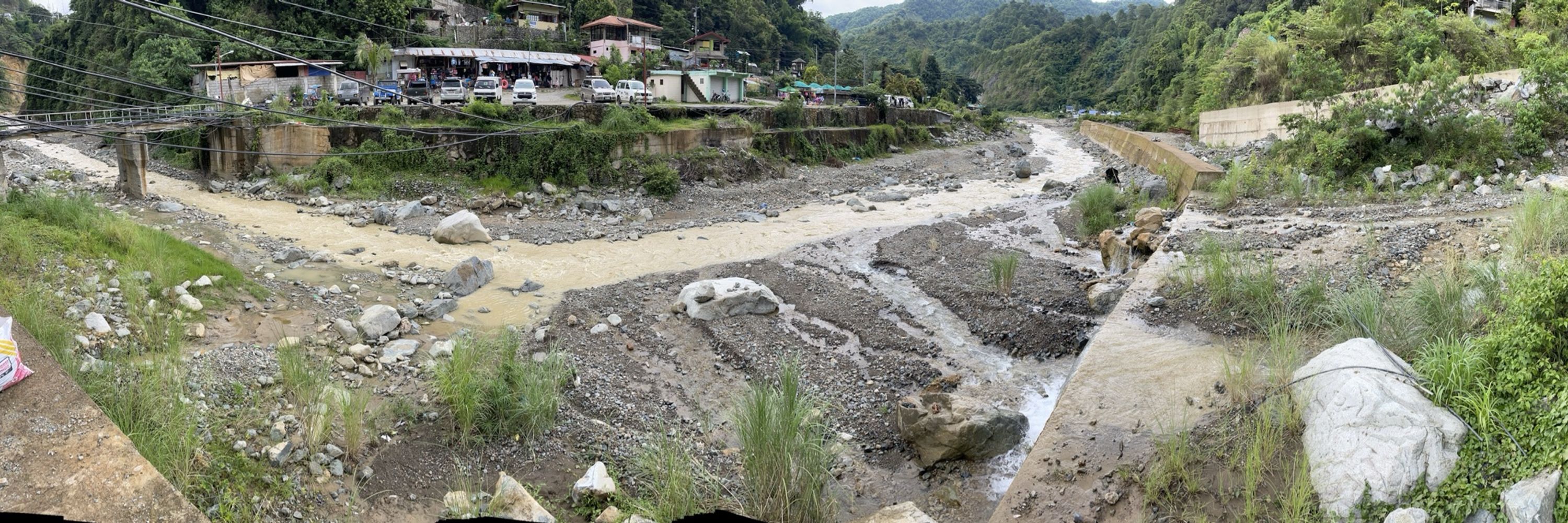
Tom Coulthard
@tomcoulthard.bsky.social
· Aug 15

In Memoriam: Dr. Sarah Praskievicz | Geography, Environment, & Sustainability Department
It is with deep sadness we share that Dr. Sarah Praskievicz, an associate professor in UNC Greensboro's Department of Geography, Environment, and Sustainability (GES), died on Aug. 11, 2025, at her ho...
ges.uncg.edu
Reposted by Tom Coulthard

CatchmentSci
@catchmentsci.bsky.social
· Aug 14
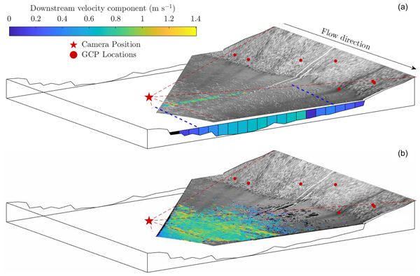
Unsupervised image velocimetry for automated computation of river flow velocities
Abstract. Accurate, long-term measurements of river flow are imperative for understanding and predicting a broad range of fluvial processes. Modern technological advances are enabling the development ...
hess.copernicus.org


Reposted by Tom Coulthard


Reposted by Tom Coulthard


Tom Coulthard
@tomcoulthard.bsky.social
· Jul 24

The Guardian
@theguardian.com
· Jul 24

It is one of the deadliest chemicals on Earth – but even Mexico’s cartels can’t resist the lure of mercury
An undercover investigation reveals 200 tonnes of the deadly substance is being smuggled across South America, where it is poisoning rivers, soil and air
www.theguardian.com
Reposted by Tom Coulthard

Luke Zoet
@lzoet.bsky.social
· Jul 24

Modeling the Influence of Grounded Landfast Ice on Nearshore Sediment Transport
XBeach was used to quantify sediment transport due to grounded landfast ice Conditions were identified where sediment transport was both amplified and reduced by ice Scour of the nearshore persi...
agupubs.onlinelibrary.wiley.com
Reposted by Tom Coulthard
Alan Puttock
@alanputtock.bsky.social
· Jul 22

Quantifying NFM through peatland re | University of Exeter
The University’s Department of Geography invites applications for a PhD studentship funded by the Environment Agency and South West Water and the University of Exeter to commence as soon as possible t...
www.exeter.ac.uk
Tom Coulthard
@tomcoulthard.bsky.social
· Jul 21
Reposted by Tom Coulthard


Tom Coulthard
@tomcoulthard.bsky.social
· Jul 21
