Sam Lillo
banner
samlillo.bsky.social
Sam Lillo
@samlillo.bsky.social
2.2K followers 150 following 360 posts
Mostly weather, dataviz, and some homesteading projects in Boulder, CO
Posts Media Videos Starter Packs
Definitive movement NNE now
Somewhat surprised not to see 155kt on the intermediate advisory. But I guess it's trivial really.
Reposted by Sam Lillo
There's the tie for the record.
Updated track map. Starting to drift bit northward - part steering, part cyclonic wobble
Reposted by Sam Lillo
A 2017 paper reassessed the history of the Advanced Dvorak Technique (ADT) for global storms since 1979. As of 10:30pm ET on October 27, #Melissa is now *unofficially* only behind 2015's Hurricane Patricia (Eastern Pacific) for highest ADT in the past 46 years.

journals.ametsoc.org/view/journal...
Always a reminder to me that even with all the wild seasons and storms in recent years, 2005 is really still in another league.
This is actually just plain unheard of in the Atlantic
Looks like it's coming around the other side of the cyclonic wobble now
CI# up to 8.2 = 176kt / 882mb (satellite estimates put Melissa at Wilma levels)
Raw back up to 8.4. Final up to 8.0 = 170kt satellite estimate.

Pretty surreal that we're just repeating the last 24 hours, as Melissa sits nearly stationary, contemplating the turn north.
Tracking Melissa.

Extreme category 5 hurricane churning in place.
Reposted by Sam Lillo
Here is a 54h WV loop of #Melissa as it underwent rapid intensification from a 60 kt TS ➡️ 150 kt cat 5 #Hurricane.

Pay attention to how "warm" eye becomes at the end of the loop which ends at 18 UTC 27 Oct.

Color scale ends at -5C & eye temp on the last few frames was warmer than that 🤯
One difference - satellite and recent recon passes show the eye has cooled a bit too.
Melissa looking pretty much the same as last night. Cloud tops cooling steadily again, raw Dvorak back up to 8.2!!
Reposted by Sam Lillo
A lightning-packed eye spins ferociously at the center of Hurricane Melissa.
And now watching every bit more west of due-north Melissa is tracking. Every wobble west is good.
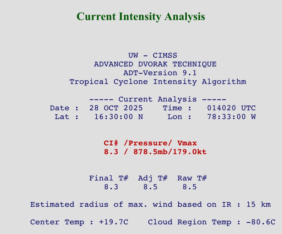
I feel like if you're in Kingston, you're watching every wobble southwestward with relief.
Reposted by Sam Lillo
The monster eye at the center of a still strengthening Hurricane Melissa.
Melissa is making the slow turn northward today, and is about to track over the warmest waters yet
The WSW motion is important for two reasons.

1) That gives more time for #Melissa to remain over the very warm waters of the Central Caribbean. Yes the hurricane is moving very slowly, but it also has a deep reservoir of oceanic heat content to give it more time than a regular 1-3 kt moving storm.
Reposted by Sam Lillo
From a crewmember on yesterday's Teal 74 mission into now-Category 5 Hurricane #Melissa. As clear of an eye as you will see in the Atlantic basin.
That's a good point, especially with recon data struggling to support the early cat 4 intensities, maybe that comes down and this actually does qualify as RI in post.
Rapid intensification gets a lot of attention and is typically part of the last push to category 5.

This wasn't the case for Melissa however. The 24 hours leading up to becoming a cat 5 was one of the most gradual intensifications for any Atlantic cat 5.
Reposted by Sam Lillo
I've seen a lot of dropsondes over my years, and a peak wind of 210kt - even at the top of/just beyond the boundary layer - is wild to see. Might be up there in the ranks of all-time strongest dropsonde-measured gusts as well.