


EarthquakeAndrew.bsky.social
@earthquakeandrew.bsky.social
Seismologist at the Geological Survey of Canada and Adjunct Professor at the University of Victoria. Science and Outreach on Vancouver Island in Southwest BC.
This won't have caused any damage, and not likely to have been felt by many. Anything to add, @earthquakeguy.bsky.social ?
Small earthquake local to Victoria, just over a half hour ago, at 12:10 PST. At 25km depth just off from Albert Head.


November 9, 2025 at 8:45 PM
This won't have caused any damage, and not likely to have been felt by many. Anything to add, @earthquakeguy.bsky.social ?
Reposted by EarthquakeAndrew.bsky.social

Quick video about the M7.8 earthquake off the coast of Russia, including an animation from @earthscope.org showing the seismic waves detected by seismic stations across North America. 🧪
September 19, 2025 at 1:04 AM
Quick video about the M7.8 earthquake off the coast of Russia, including an animation from @earthscope.org showing the seismic waves detected by seismic stations across North America. 🧪
Reposted by EarthquakeAndrew.bsky.social

This mornings M3.0 felt earthquake near Duncan was well recorded on the #SchoolShake network. No damages expected, but a great reminder to be prepared.
Felt reports and details: www.earthquakescanada.nrcan.gc.ca/recent/2025/...
Felt reports and details: www.earthquakescanada.nrcan.gc.ca/recent/2025/...


September 18, 2025 at 9:36 PM
This mornings M3.0 felt earthquake near Duncan was well recorded on the #SchoolShake network. No damages expected, but a great reminder to be prepared.
Felt reports and details: www.earthquakescanada.nrcan.gc.ca/recent/2025/...
Felt reports and details: www.earthquakescanada.nrcan.gc.ca/recent/2025/...
Reposted by EarthquakeAndrew.bsky.social
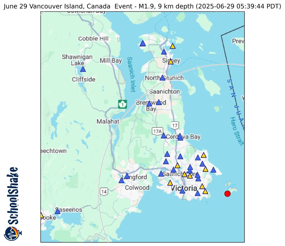
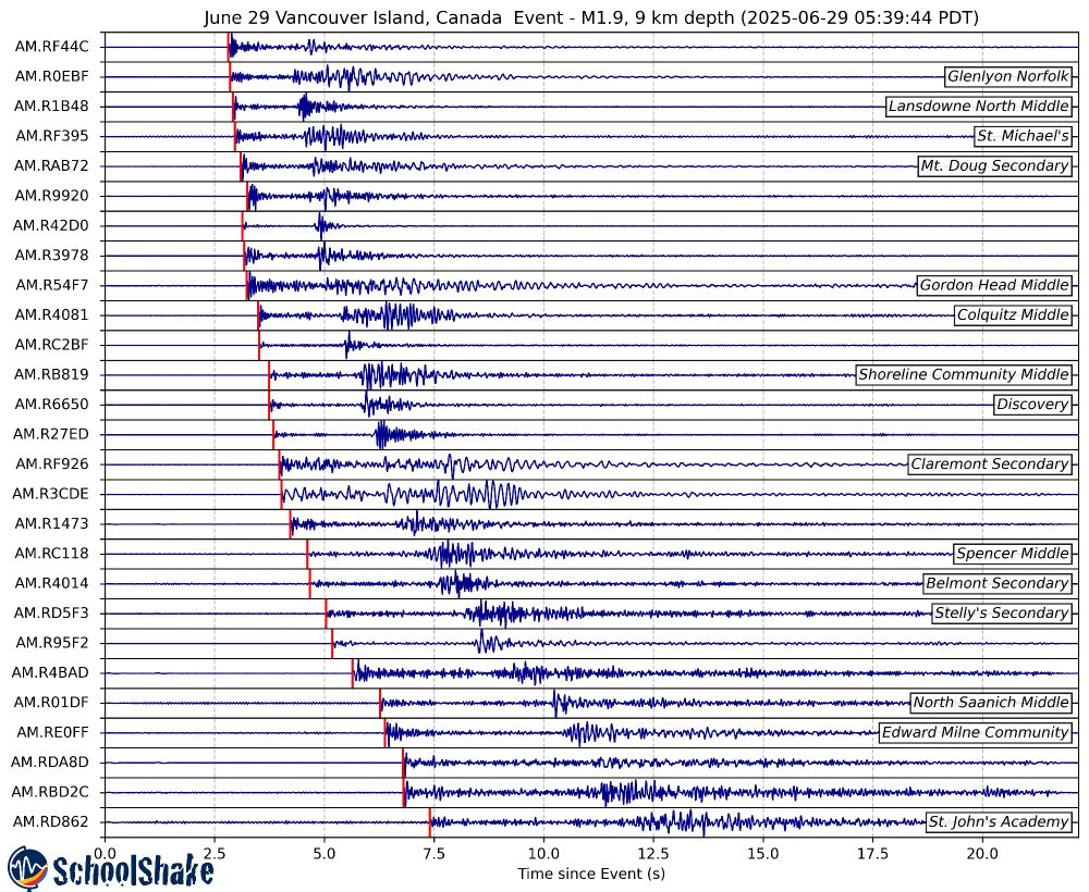
Small M1.9 earthquake this morning just offshore #VictoriaBC, at 5:39 am PDT, at 9 km depth. While not large enough to cause damage and not likely to be felt, another reminder of the hazard across the region. Well recoded by the @schoolshake.bsky.social @raspishake.bsky.social network.
June 29, 2025 at 7:06 PM
Small M1.9 earthquake this morning just offshore #VictoriaBC, at 5:39 am PDT, at 9 km depth. While not large enough to cause damage and not likely to be felt, another reminder of the hazard across the region. Well recoded by the @schoolshake.bsky.social @raspishake.bsky.social network.
Reposted by EarthquakeAndrew.bsky.social

Dusting off our lidar drone ahead of the summer surveying season @thatfaultguy.bsky.social @earthquakeandrew.bsky.social

May 31, 2025 at 12:29 AM
Dusting off our lidar drone ahead of the summer surveying season @thatfaultguy.bsky.social @earthquakeandrew.bsky.social
Another local earthquake, beneath the south end of the peninsula. Once again really nicely picked up by the @schoolshake.bsky.social @raspishake.bsky.social network operated by @seos-uvic.bsky.social, @hakai.org and the Geological Survey of Canada.
Victoria, there was a small earthquake 17km below South Oak Bay in the wee hours last night (around 03:41 AM). This was really well detected by our @raspishake.bsky.social network of @schoolshake.bsky.social seismometers! This was a very small event at depth, so would definitely not cause any damage


May 7, 2025 at 11:11 PM
Another local earthquake, beneath the south end of the peninsula. Once again really nicely picked up by the @schoolshake.bsky.social @raspishake.bsky.social network operated by @seos-uvic.bsky.social, @hakai.org and the Geological Survey of Canada.
Reposted by EarthquakeAndrew.bsky.social
A shallow Magnitude ~2.5 occurred 5:41pm local time near the Canada-US border, between Langley and Abbotsford. Detected with @raspishake.bsky.social instruments across the MVRD and CRD.


April 3, 2025 at 1:01 AM
A shallow Magnitude ~2.5 occurred 5:41pm local time near the Canada-US border, between Langley and Abbotsford. Detected with @raspishake.bsky.social instruments across the MVRD and CRD.
Reposted by EarthquakeAndrew.bsky.social
The Geological Survey of Canada (Pacific Geoscience Centre near Victoria, BC and Vancouver, BC) has an opening for a research scientist in Earthquake Seismology. Join a great, diverse team doing cutting edge science. ⚒️🧪
Details:
emploisfp-psjobs.cfp-psc.gc.ca/psrs-srfp/ap...
Apply by 25 April, 2025
Details:
emploisfp-psjobs.cfp-psc.gc.ca/psrs-srfp/ap...
Apply by 25 April, 2025
March 31, 2025 at 8:48 PM
The Geological Survey of Canada (Pacific Geoscience Centre near Victoria, BC and Vancouver, BC) has an opening for a research scientist in Earthquake Seismology. Join a great, diverse team doing cutting edge science. ⚒️🧪
Details:
emploisfp-psjobs.cfp-psc.gc.ca/psrs-srfp/ap...
Apply by 25 April, 2025
Details:
emploisfp-psjobs.cfp-psc.gc.ca/psrs-srfp/ap...
Apply by 25 April, 2025
Reposted by EarthquakeAndrew.bsky.social

The latest models from the USGS show slip, and associated strong shaking, extending much further to the south. Here I have plotted contours of estimated shaking over a map of population density. Note that the fault runs south through a narrow valley that is densely populated.
⚒️ 🧪 Myanmar earthquake
⚒️ 🧪 Myanmar earthquake

March 29, 2025 at 2:09 PM
The latest models from the USGS show slip, and associated strong shaking, extending much further to the south. Here I have plotted contours of estimated shaking over a map of population density. Note that the fault runs south through a narrow valley that is densely populated.
⚒️ 🧪 Myanmar earthquake
⚒️ 🧪 Myanmar earthquake
Reposted by EarthquakeAndrew.bsky.social
Reminder that polls mean nothing unless you get out and vote! elections.ca
Elections Canada On-line - Élections Canada en ligne
Elections Canada is the independent, non-partisan agency responsible for conducting federal elections and referendums.
elections.ca
March 29, 2025 at 2:38 PM
Reminder that polls mean nothing unless you get out and vote! elections.ca
Reposted by EarthquakeAndrew.bsky.social
See our write-up about this earthquake on Earthquake Insights:
earthquakeinsights.substack.com/p/catastroph...
earthquakeinsights.substack.com/p/catastroph...

Catastrophic M7.7 earthquake caused by rupture of Sagaing Fault in Myanmar
Limited reporting thus far from Myanmar, but this is a big one
earthquakeinsights.substack.com
March 28, 2025 at 5:14 PM
See our write-up about this earthquake on Earthquake Insights:
earthquakeinsights.substack.com/p/catastroph...
earthquakeinsights.substack.com/p/catastroph...
Just curious, any other seismologists out there having difficulty getting data from the @earthscope.org SAGE/GAGE fdsnws services, or are getting a "system currently overloaded" message from the web-based metadata aggregator?
March 23, 2025 at 5:13 PM
Just curious, any other seismologists out there having difficulty getting data from the @earthscope.org SAGE/GAGE fdsnws services, or are getting a "system currently overloaded" message from the web-based metadata aggregator?
Reposted by EarthquakeAndrew.bsky.social

The US Geological Survey (in the Dept of the Interior) is the federal agency that runs our volcano observatories & monitors volcanoes in the US for imminent eruption. Their work is critical to protect lives & infrastructure when volcanoes awaken like this. 🌋

The closest active volcano to Anchorage — Mount Spurr — is now expected to erupt within the next few weeks.
Would be a great time to have a fully-staffed NOAA to help navigate the impacts of this likely disaster.
www.adn.com/alaska-news/...
Would be a great time to have a fully-staffed NOAA to help navigate the impacts of this likely disaster.
www.adn.com/alaska-news/...
March 12, 2025 at 8:57 PM
The US Geological Survey (in the Dept of the Interior) is the federal agency that runs our volcano observatories & monitors volcanoes in the US for imminent eruption. Their work is critical to protect lives & infrastructure when volcanoes awaken like this. 🌋
Reposted by EarthquakeAndrew.bsky.social
Small Earthquake just off from Colwood this afternoon at 4:24 PM local time. A small M0.8 event at 9 km depth, but still detectable with the local seismic networks and a few of the SchoolShake stations!


March 13, 2025 at 12:04 AM
Small Earthquake just off from Colwood this afternoon at 4:24 PM local time. A small M0.8 event at 9 km depth, but still detectable with the local seismic networks and a few of the SchoolShake stations!
Reposted by EarthquakeAndrew.bsky.social

To celebrate @mark-carney.bsky.social’s decisive win of the @liberalca.bsky.social leadership contest I’ll be drinking a Canadian English ale. Mr Carney was Governor of both Bank of Canada and Bank of England, after all. #FinestHour 🇨🇦

March 10, 2025 at 12:25 AM
To celebrate @mark-carney.bsky.social’s decisive win of the @liberalca.bsky.social leadership contest I’ll be drinking a Canadian English ale. Mr Carney was Governor of both Bank of Canada and Bank of England, after all. #FinestHour 🇨🇦
Reposted by EarthquakeAndrew.bsky.social
Another small but felt earthquake occured March 6th at 16:18 PST, deep within the Olympic Mountains of Washington State. While a M3.8-3.9, at 42km depth it was not as widely felt as Monday's. Picked up nicely on the SchoolShake @raspishake.bsky.social Network.


March 6, 2025 at 3:14 AM
Another small but felt earthquake occured March 6th at 16:18 PST, deep within the Olympic Mountains of Washington State. While a M3.8-3.9, at 42km depth it was not as widely felt as Monday's. Picked up nicely on the SchoolShake @raspishake.bsky.social Network.
Reposted by EarthquakeAndrew.bsky.social
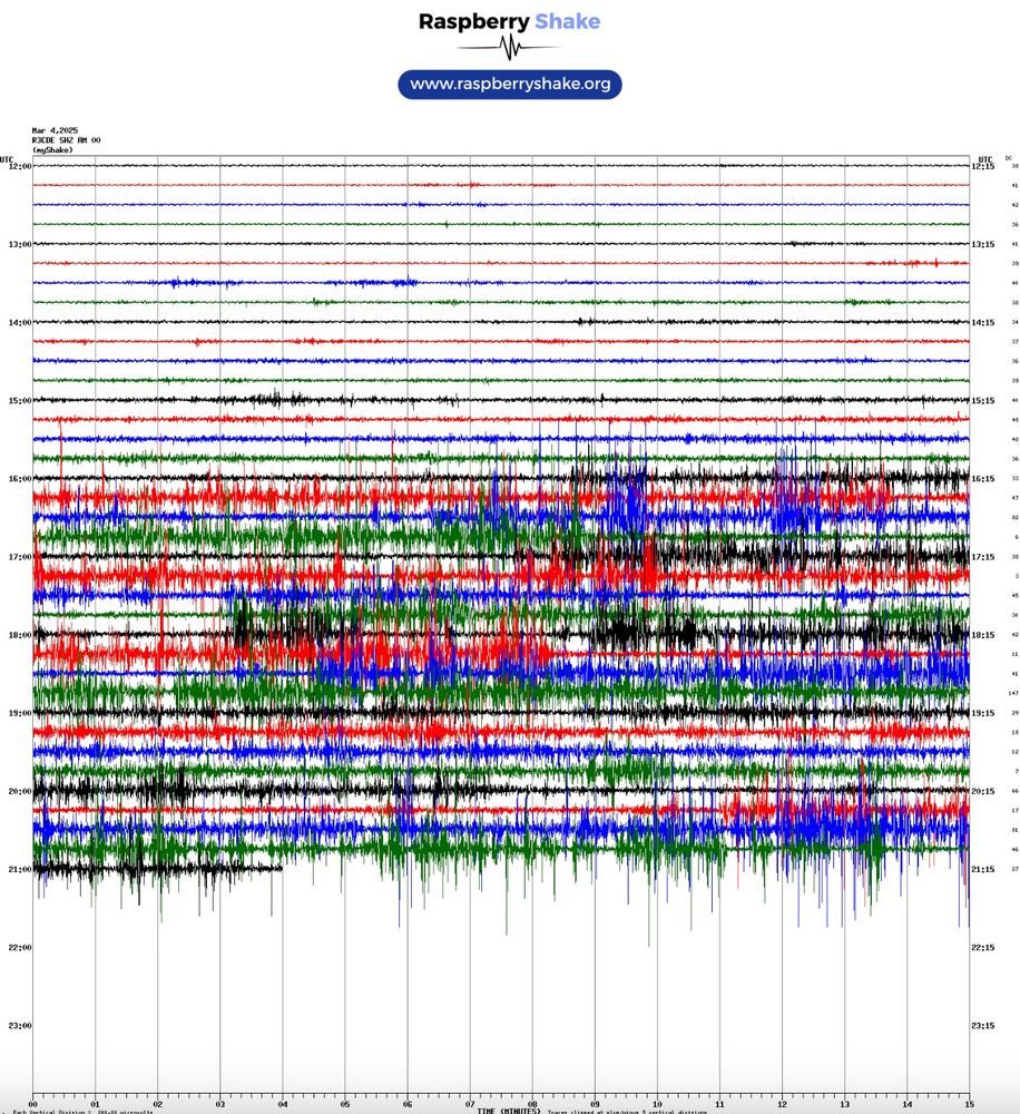
Uh oh... some new house construction in the neighbourhood and ground shaking from the excavator shows up nicely on my RaspberryShake seismometer. Sadly, this will hide shaking from any tiny daytime #earthquakes...
Thanks @raspberrypi.com @earthquakeandrew.bsky.social
⚒️🧪
Thanks @raspberrypi.com @earthquakeandrew.bsky.social
⚒️🧪
March 4, 2025 at 9:28 PM
Uh oh... some new house construction in the neighbourhood and ground shaking from the excavator shows up nicely on my RaspberryShake seismometer. Sadly, this will hide shaking from any tiny daytime #earthquakes...
Thanks @raspberrypi.com @earthquakeandrew.bsky.social
⚒️🧪
Thanks @raspberrypi.com @earthquakeandrew.bsky.social
⚒️🧪
Very nice signals across southwest BC picked up by the @schoolshake.bsky.social Raspberry Shake seismic network, operated by the Geological Survey of Canada, @seos-uvic.bsky.social, and @hakai.org
Mw 4.1 Earthquake beneath Orcas Island, this morning at 05:03:37 PST. The earthquake occurred at a depth of 17 km, and was felt across the region. Attached is the location of the event, as well as the signal from it recorded on Raspberry Shake Seismometer throughout the region!


March 3, 2025 at 5:48 PM
Very nice signals across southwest BC picked up by the @schoolshake.bsky.social Raspberry Shake seismic network, operated by the Geological Survey of Canada, @seos-uvic.bsky.social, and @hakai.org
Lovely flowers out already. It feels so early for them, but somehow it is already March!


March 2, 2025 at 3:55 AM
Lovely flowers out already. It feels so early for them, but somehow it is already March!
Reposted by EarthquakeAndrew.bsky.social
M5 earthquake north of Sechelt, BC, occurred at 13:26:33 local time (PST). Widely felt across the Sunshine Coast, Lower Mainland and Vancouver Island. Picked up across the SchoolShake Network.


February 21, 2025 at 10:13 PM
M5 earthquake north of Sechelt, BC, occurred at 13:26:33 local time (PST). Widely felt across the Sunshine Coast, Lower Mainland and Vancouver Island. Picked up across the SchoolShake Network.
Reposted by EarthquakeAndrew.bsky.social
🧪⚒️
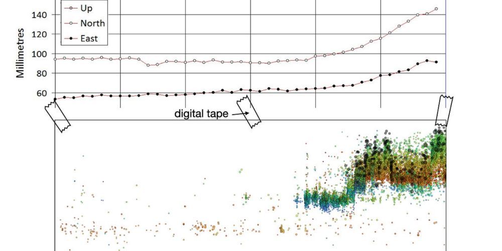
The seismic swarm in Greece continues - and GPS stations on Santorini show that the island itself is deforming, signaling likely movement of magma deep in the crust. In our latest post, we explore a new detailed seismic catalog and come up with a possible interpretation.
Read more:
The seismic swarm in Greece continues - and GPS stations on Santorini show that the island itself is deforming, signaling likely movement of magma deep in the crust. In our latest post, we explore a new detailed seismic catalog and come up with a possible interpretation.
Read more:
The seismic swarm in Greece gets more complicated
New data reveal unexpected volcano-tectonic interactions
earthquakeinsights.substack.com
February 14, 2025 at 9:51 PM
🧪⚒️
The seismic swarm in Greece continues - and GPS stations on Santorini show that the island itself is deforming, signaling likely movement of magma deep in the crust. In our latest post, we explore a new detailed seismic catalog and come up with a possible interpretation.
Read more:
The seismic swarm in Greece continues - and GPS stations on Santorini show that the island itself is deforming, signaling likely movement of magma deep in the crust. In our latest post, we explore a new detailed seismic catalog and come up with a possible interpretation.
Read more:
Did you feel the M~3.8 earthquake South of Victoria,BC, just a few minutes ago (21:59:18 PST)? If you did, register your experience with Earthquakes Canada Did you feel it! Nicely picked up across the @schoolshake.bsky.social Network!


February 14, 2025 at 6:11 AM
Did you feel the M~3.8 earthquake South of Victoria,BC, just a few minutes ago (21:59:18 PST)? If you did, register your experience with Earthquakes Canada Did you feel it! Nicely picked up across the @schoolshake.bsky.social Network!
Reposted by EarthquakeAndrew.bsky.social
Here are the waveforms from the 23:23 UTC Cayman Islands Mw7.6 that occurred earlier today. You can see the waves arrive across the SchoolShake Network Raspberry Shakes in South West BC a bit more than 8 minutes after the earthquake.


February 9, 2025 at 2:49 AM
Here are the waveforms from the 23:23 UTC Cayman Islands Mw7.6 that occurred earlier today. You can see the waves arrive across the SchoolShake Network Raspberry Shakes in South West BC a bit more than 8 minutes after the earthquake.
Reposted by EarthquakeAndrew.bsky.social

Hello all my #Quaternary #Geology friends, the Yukon Geologic Survey is hiring a term position (until Sept. 2026)
in surficial geology.
It just opened and closes fast, Feb 17th, so if you are interested, jump quickly. ⚒️🧪
in surficial geology.
It just opened and closes fast, Feb 17th, so if you are interested, jump quickly. ⚒️🧪

YG - E-Recruitment -
Surficial Geologist - (58046)
yukongovernment.hua.hrsmart.com
February 4, 2025 at 11:26 PM
Hello all my #Quaternary #Geology friends, the Yukon Geologic Survey is hiring a term position (until Sept. 2026)
in surficial geology.
It just opened and closes fast, Feb 17th, so if you are interested, jump quickly. ⚒️🧪
in surficial geology.
It just opened and closes fast, Feb 17th, so if you are interested, jump quickly. ⚒️🧪
Reposted by EarthquakeAndrew.bsky.social

Regarding the earthquakes near the greek island of #Santorini there a few things to know.
#Earthquake swarms are common throughout the aegean, and usually they end without causing problems. So there is a high likelyhood that nothing will happen.
However, there are several potential issues.
1/7
#Earthquake swarms are common throughout the aegean, and usually they end without causing problems. So there is a high likelyhood that nothing will happen.
However, there are several potential issues.
1/7
February 4, 2025 at 8:10 PM
Regarding the earthquakes near the greek island of #Santorini there a few things to know.
#Earthquake swarms are common throughout the aegean, and usually they end without causing problems. So there is a high likelyhood that nothing will happen.
However, there are several potential issues.
1/7
#Earthquake swarms are common throughout the aegean, and usually they end without causing problems. So there is a high likelyhood that nothing will happen.
However, there are several potential issues.
1/7