


Gilles Mazet-Roux
@gmazet.bsky.social
Research engineer in seismology. Uprooted Savoyard born in 332 ppm.
Reposted by Gilles Mazet-Roux

Cool study that uses acoustic signals recorded at seismic sensors to identify aircraft type flying overhead (different aircraft have different frequency signatures). Alaska provides a lot of aircraft variety to evaluate. ⚒️🧪🚁
pubs.geoscienceworld.org/ssa/tsr/arti...
pubs.geoscienceworld.org/ssa/tsr/arti...

November 20, 2025 at 5:58 PM
Cool study that uses acoustic signals recorded at seismic sensors to identify aircraft type flying overhead (different aircraft have different frequency signatures). Alaska provides a lot of aircraft variety to evaluate. ⚒️🧪🚁
pubs.geoscienceworld.org/ssa/tsr/arti...
pubs.geoscienceworld.org/ssa/tsr/arti...
Reposted by Gilles Mazet-Roux

[Séisme ressenti]
Un séisme a été enregistré le lundi 27 octobre 2025 à 08:38 heure locale.
➡️ magnitude 6.6 ± 0.3
➡️ localisé à 168km à l'Est de la Désirade
➡️ type Tectonique
👉Si vous l'avez ressenti, merci de nous aider en témoignant sur www.franceseisme.fr
Un séisme a été enregistré le lundi 27 octobre 2025 à 08:38 heure locale.
➡️ magnitude 6.6 ± 0.3
➡️ localisé à 168km à l'Est de la Désirade
➡️ type Tectonique
👉Si vous l'avez ressenti, merci de nous aider en témoignant sur www.franceseisme.fr

October 27, 2025 at 1:43 PM
[Séisme ressenti]
Un séisme a été enregistré le lundi 27 octobre 2025 à 08:38 heure locale.
➡️ magnitude 6.6 ± 0.3
➡️ localisé à 168km à l'Est de la Désirade
➡️ type Tectonique
👉Si vous l'avez ressenti, merci de nous aider en témoignant sur www.franceseisme.fr
Un séisme a été enregistré le lundi 27 octobre 2025 à 08:38 heure locale.
➡️ magnitude 6.6 ± 0.3
➡️ localisé à 168km à l'Est de la Désirade
➡️ type Tectonique
👉Si vous l'avez ressenti, merci de nous aider en témoignant sur www.franceseisme.fr
#Kamtchatka earthquakes sequences update. The activity remains concentrated to the north of the rupture zone.

September 19, 2025 at 6:40 AM
#Kamtchatka earthquakes sequences update. The activity remains concentrated to the north of the rupture zone.
I'm glad to see that good old GMT is still considered trendy software 👍 Often copied, never equaled

Registration is now open for the 2025 Introduction to the Generic Mapping Tools (GMT) for Geophysics short course! This self-paced, asynchronous course introducing learners to modern GMT is available to complete between September 2–25, 2025.
Register by August 28 ➡️ https://loom.ly/hcbJrIQ
Register by August 28 ➡️ https://loom.ly/hcbJrIQ

August 7, 2025 at 2:46 PM
I'm glad to see that good old GMT is still considered trendy software 👍 Often copied, never equaled

August 5, 2025 at 7:00 AM
Reposted by Gilles Mazet-Roux

Really American
Democracy in Danger: In a shocking moment, Stacey Abrams lays out in terrifying detail the methodical ten step process by which our democracy is being dismantled, and we might be at step nine already.😲🤬
Everyone needs to see this.
Democracy in Danger: In a shocking moment, Stacey Abrams lays out in terrifying detail the methodical ten step process by which our democracy is being dismantled, and we might be at step nine already.😲🤬
Everyone needs to see this.
July 9, 2025 at 11:49 PM
Really American
Democracy in Danger: In a shocking moment, Stacey Abrams lays out in terrifying detail the methodical ten step process by which our democracy is being dismantled, and we might be at step nine already.😲🤬
Everyone needs to see this.
Democracy in Danger: In a shocking moment, Stacey Abrams lays out in terrifying detail the methodical ten step process by which our democracy is being dismantled, and we might be at step nine already.😲🤬
Everyone needs to see this.
48 hours hours after the #tsunami hit the Marquises Islands in French Polynesia, the waters in Nuku Hiva harbour are still agitated. (Source data.shom.fr)

August 1, 2025 at 9:40 AM
48 hours hours after the #tsunami hit the Marquises Islands in French Polynesia, the waters in Nuku Hiva harbour are still agitated. (Source data.shom.fr)
Reposted by Gilles Mazet-Roux

Thanks to the authority in NZ, we have English version of the picture!
www.geonet.org.nz/news/7KdKuPl...
www.geonet.org.nz/news/7KdKuPl...

August 1, 2025 at 1:56 AM
Thanks to the authority in NZ, we have English version of the picture!
www.geonet.org.nz/news/7KdKuPl...
www.geonet.org.nz/news/7KdKuPl...
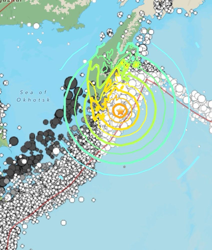
The magnitude 8.8 earthquake that struck #Kamtchatka on 29 July produced approximately 230 #aftershocks of magnitude 4 and above within 30 hours, which were distributed over an area measuring approximately 350 x 80 km.
(Earthquake data: @lastquake.emsc.eu )
(Earthquake data: @lastquake.emsc.eu )

July 31, 2025 at 9:00 AM
The magnitude 8.8 earthquake that struck #Kamtchatka on 29 July produced approximately 230 #aftershocks of magnitude 4 and above within 30 hours, which were distributed over an area measuring approximately 350 x 80 km.
(Earthquake data: @lastquake.emsc.eu )
(Earthquake data: @lastquake.emsc.eu )
Reposted by Gilles Mazet-Roux

Tsunami visible sur le marégraphe de Nuku Hiva d'après les données temps réel du SHOM
services.data.shom.fr/maregraphie/...
services.data.shom.fr/maregraphie/...

July 30, 2025 at 11:53 AM
Tsunami visible sur le marégraphe de Nuku Hiva d'après les données temps réel du SHOM
services.data.shom.fr/maregraphie/...
services.data.shom.fr/maregraphie/...
The M8.7 aftershocks are distributed on a ~ 350-km long x 100 km wide area.
But actually the seismic crisis bagan on July 20 in #Kamtchatka. The foreshock sequence was concentrated on the north-east end of the rupture.
#Tsunami
But actually the seismic crisis bagan on July 20 in #Kamtchatka. The foreshock sequence was concentrated on the north-east end of the rupture.
#Tsunami

July 30, 2025 at 11:24 AM
The M8.7 aftershocks are distributed on a ~ 350-km long x 100 km wide area.
But actually the seismic crisis bagan on July 20 in #Kamtchatka. The foreshock sequence was concentrated on the north-east end of the rupture.
#Tsunami
But actually the seismic crisis bagan on July 20 in #Kamtchatka. The foreshock sequence was concentrated on the north-east end of the rupture.
#Tsunami
Reposted by Gilles Mazet-Roux

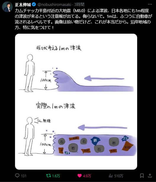
On X, Masaki Nobushiro posts a recurring (and useful) drawing about how people wrongly think a 1m tsunami is a cresting wave when it's actually a wall of water filled with dangerous and deadly debris that's strong enough to sweep up a car.
#tsunami
#tsunami
July 30, 2025 at 3:29 AM
On X, Masaki Nobushiro posts a recurring (and useful) drawing about how people wrongly think a 1m tsunami is a cresting wave when it's actually a wall of water filled with dangerous and deadly debris that's strong enough to sweep up a car.
#tsunami
#tsunami
Reposted by Gilles Mazet-Roux

Magnitude 8.7 #earthquake in Kamchatka, following a M7.4 last week - may be largest earthquake since 2011, 8th largest on record globally, #tsunami warning in place for US west coast and Canada - the historic 1952 M9 closely caused a destructive tsunami across the Pacific
July 30, 2025 at 1:00 AM
Magnitude 8.7 #earthquake in Kamchatka, following a M7.4 last week - may be largest earthquake since 2011, 8th largest on record globally, #tsunami warning in place for US west coast and Canada - the historic 1952 M9 closely caused a destructive tsunami across the Pacific
Reposted by Gilles Mazet-Roux

14 August 1846 12:00 UT
Mw6.0 earthquake almost destroyed Orciano Pisano, near Livorno (Tuscany, Northern Italy), killing 60 people. Felt as far as Milan. Four months of aftershocks.
emidius.mi.ingv.it/ASMI/event/1...
imuseum.im
e-newspaperarchives.ch
Largest known EQ in that area...
Mw6.0 earthquake almost destroyed Orciano Pisano, near Livorno (Tuscany, Northern Italy), killing 60 people. Felt as far as Milan. Four months of aftershocks.
emidius.mi.ingv.it/ASMI/event/1...
imuseum.im
e-newspaperarchives.ch
Largest known EQ in that area...


August 14, 2024 at 10:56 AM
14 August 1846 12:00 UT
Mw6.0 earthquake almost destroyed Orciano Pisano, near Livorno (Tuscany, Northern Italy), killing 60 people. Felt as far as Milan. Four months of aftershocks.
emidius.mi.ingv.it/ASMI/event/1...
imuseum.im
e-newspaperarchives.ch
Largest known EQ in that area...
Mw6.0 earthquake almost destroyed Orciano Pisano, near Livorno (Tuscany, Northern Italy), killing 60 people. Felt as far as Milan. Four months of aftershocks.
emidius.mi.ingv.it/ASMI/event/1...
imuseum.im
e-newspaperarchives.ch
Largest known EQ in that area...
Reposted by Gilles Mazet-Roux

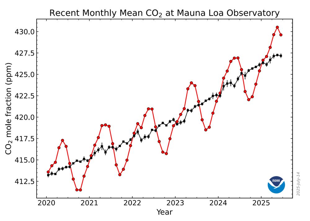
Will this be the last Keeling curve upate from NOAA for CO2 at Mauna Loa?
June 2025: 429.61 ppm
This may be a tragic moment:
June 2025: 429.61 ppm
This may be a tragic moment:
July 15, 2025 at 12:41 AM
Will this be the last Keeling curve upate from NOAA for CO2 at Mauna Loa?
June 2025: 429.61 ppm
This may be a tragic moment:
June 2025: 429.61 ppm
This may be a tragic moment:
Reposted by Gilles Mazet-Roux

A huge blow was dealt to hurricane forecasters this week as a critical tool was abruptly terminated by the Department of Defense and NOAA. The immediate discontinuation of data from three weather satellites will severely impact hurricane forecasts this season and beyond. More ⬇️
Critical Hurricane Forecast Tool Abruptly Terminated
U.S. Department of Defense announced Tuesday it would no longer process and deliver data essential to most hurricane forecasts
michaelrlowry.substack.com
June 26, 2025 at 1:17 PM
A huge blow was dealt to hurricane forecasters this week as a critical tool was abruptly terminated by the Department of Defense and NOAA. The immediate discontinuation of data from three weather satellites will severely impact hurricane forecasts this season and beyond. More ⬇️
This morning @lastquake.bsky.social reports a magnitude 4.5 earthquake on the SE coast of #Greenland.
www.emsc-csem.org/Earthquake_i...
This is probably not an earthquake, but rather a huge landslide in a fjord caused by thawing #permafrost. To be confirmed ...
www.emsc-csem.org/Earthquake_i...
This is probably not an earthquake, but rather a huge landslide in a fjord caused by thawing #permafrost. To be confirmed ...
June 21, 2025 at 11:23 AM
This morning @lastquake.bsky.social reports a magnitude 4.5 earthquake on the SE coast of #Greenland.
www.emsc-csem.org/Earthquake_i...
This is probably not an earthquake, but rather a huge landslide in a fjord caused by thawing #permafrost. To be confirmed ...
www.emsc-csem.org/Earthquake_i...
This is probably not an earthquake, but rather a huge landslide in a fjord caused by thawing #permafrost. To be confirmed ...
Reposted by Gilles Mazet-Roux

#Greenland melting 19.06.2025
We are going parabolic
Finally some #Climate action in the #cryosphere
But the NEWS OF THE DAY is not this.
You will need to wait 2 hours to find out
#ClimateCrisis #cryosphere
We are going parabolic
Finally some #Climate action in the #cryosphere
But the NEWS OF THE DAY is not this.
You will need to wait 2 hours to find out
#ClimateCrisis #cryosphere

June 20, 2025 at 6:35 AM
#Greenland melting 19.06.2025
We are going parabolic
Finally some #Climate action in the #cryosphere
But the NEWS OF THE DAY is not this.
You will need to wait 2 hours to find out
#ClimateCrisis #cryosphere
We are going parabolic
Finally some #Climate action in the #cryosphere
But the NEWS OF THE DAY is not this.
You will need to wait 2 hours to find out
#ClimateCrisis #cryosphere
Reposted by Gilles Mazet-Roux

It seems My Etna is active this morning.
This is an 8x Timelapse of the moment of eruption
This is an 8x Timelapse of the moment of eruption
June 2, 2025 at 1:05 PM
It seems My Etna is active this morning.
This is an 8x Timelapse of the moment of eruption
This is an 8x Timelapse of the moment of eruption
Reposted by Gilles Mazet-Roux
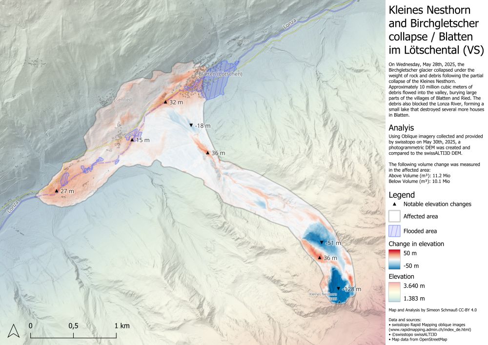
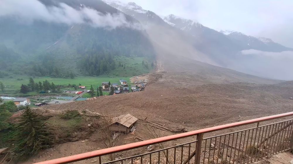
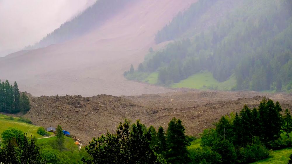
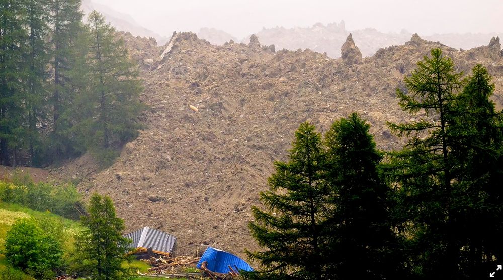
Finally some precise numbers for the Blatten deposit! 👇
11 Mio m3 and up to 32 m thick ! 😱
11 Mio m3 and up to 32 m thick ! 😱

I also derived a new elevation model from the aerial images, allowing me to visualize the elevation change in the affected areas.
The rocks and debris in the valley are locally up to 32m thick and I estimate the total displaced volume is about 11 million cubic meters. #Blatten
The rocks and debris in the valley are locally up to 32m thick and I estimate the total displaced volume is about 11 million cubic meters. #Blatten
June 1, 2025 at 1:52 PM
Finally some precise numbers for the Blatten deposit! 👇
11 Mio m3 and up to 32 m thick ! 😱
11 Mio m3 and up to 32 m thick ! 😱
Reposted by Gilles Mazet-Roux
FACTSHEET about Birch Glacier collapse by glaciologists of ETHZ @vaw-glaciology.bsky.social 🧊❄️
Don't miss that read! 🙏
polybox.ethz.ch/index.php/s/...
📷 Pomona
Don't miss that read! 🙏
polybox.ethz.ch/index.php/s/...
📷 Pomona

May 29, 2025 at 10:50 AM
FACTSHEET about Birch Glacier collapse by glaciologists of ETHZ @vaw-glaciology.bsky.social 🧊❄️
Don't miss that read! 🙏
polybox.ethz.ch/index.php/s/...
📷 Pomona
Don't miss that read! 🙏
polybox.ethz.ch/index.php/s/...
📷 Pomona
Reposted by Gilles Mazet-Roux

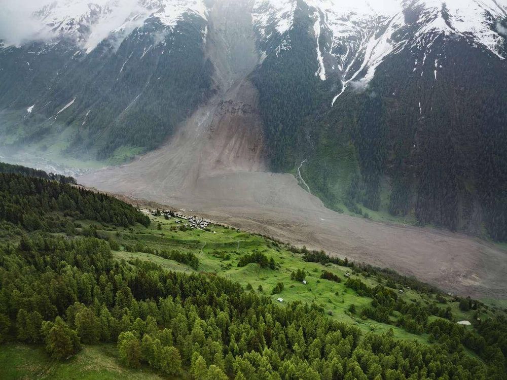
My friend is in charge of the team that wrote the climate change adaptation plan for Switzerland and this is one of the things they expected.
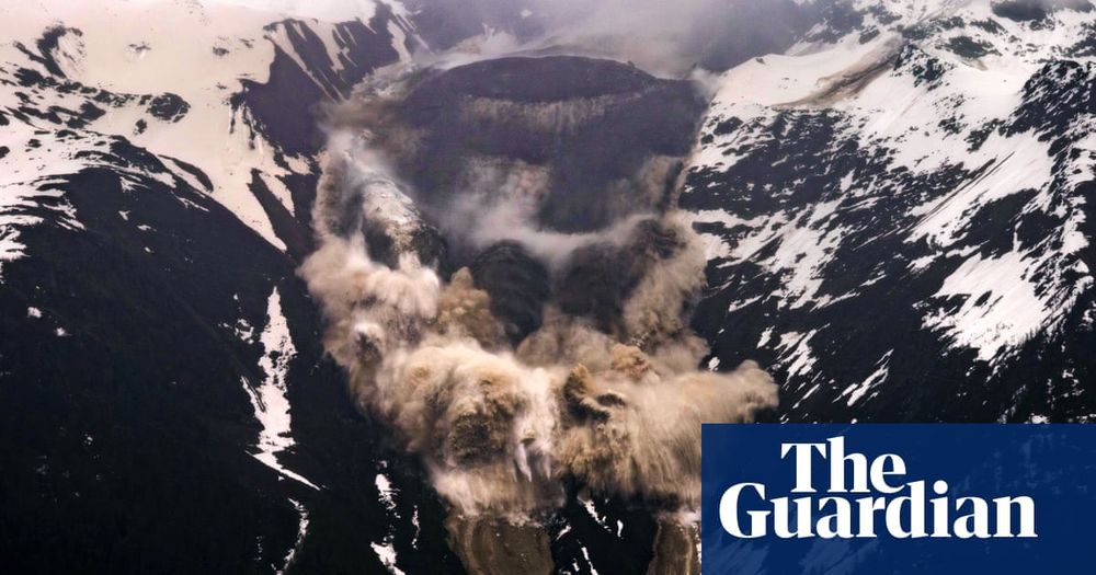
Swiss village almost entirely destroyed after collapse of glacier buries it in mud
One person missing and Blatten devastated after huge cloud of ice and rubble inundates evacuated town
www.theguardian.com
May 29, 2025 at 6:24 AM
My friend is in charge of the team that wrote the climate change adaptation plan for Switzerland and this is one of the things they expected.
Reposted by Gilles Mazet-Roux
Helicopter view published by Pomona Media (🔗 below) shows the lake building up by the end of the day. 5 m3/s is a lot of water.
youtu.be/R0YlCNDW2l4?...
youtu.be/R0YlCNDW2l4?...


May 28, 2025 at 8:30 PM
Helicopter view published by Pomona Media (🔗 below) shows the lake building up by the end of the day. 5 m3/s is a lot of water.
youtu.be/R0YlCNDW2l4?...
youtu.be/R0YlCNDW2l4?...
Reposted by Gilles Mazet-Roux
May 28, 2025 at 4:14 PM