


Kireon @ Life™
@kireon.bsky.social
Lvl 37 | Agender-Asexual-Autistic | They/Them | Full-Time Office Employee | Writer of Things | Tea Enthusiast | 🔞 - No Minors, please | FUB free, NOT A F4F ACCT. Pfp by @skatuyart
Kireon @ tumblr
KireonWrites @ twitter
Kireon @ Ao3
Kireon @ tumblr
KireonWrites @ twitter
Kireon @ Ao3
Pinned
#kiraposting Weather Alert 🧵
PNW folks (WA, BC, OR, and NorCal), we're about to get smacked with a megastorm that'll drop roughly a month+'s worth of rain on us over the course of a week to a week and a half.
Landslides, flooding (rivers, creeks, and streets) is going to happen. Trees may-
PNW folks (WA, BC, OR, and NorCal), we're about to get smacked with a megastorm that'll drop roughly a month+'s worth of rain on us over the course of a week to a week and a half.
Landslides, flooding (rivers, creeks, and streets) is going to happen. Trees may-
Reposted by Kireon @ Life™

I was going to reopen 2 slots for my comms waitlist, but one is likely going to be already taken, so only one for now!
Info is at theosuren.art, DM with your idea if interested 🖤
Info is at theosuren.art, DM with your idea if interested 🖤

Theo Suren Art
Freelance digital artist specializing in fantasy romantic and suggestive imagery.
theosuren.art
December 11, 2025 at 7:02 PM
I was going to reopen 2 slots for my comms waitlist, but one is likely going to be already taken, so only one for now!
Info is at theosuren.art, DM with your idea if interested 🖤
Info is at theosuren.art, DM with your idea if interested 🖤
#kiraposting I appreciate everyone's patience, reposting, sharing, etc re: the two-three times or so updates for the flooding going on in my region. It's not what you come to this account for, I know, and I'm grateful you're all here.
This is a disaster predominantly impacting farmers and people-
This is a disaster predominantly impacting farmers and people-
December 11, 2025 at 5:00 PM
#kiraposting I appreciate everyone's patience, reposting, sharing, etc re: the two-three times or so updates for the flooding going on in my region. It's not what you come to this account for, I know, and I'm grateful you're all here.
This is a disaster predominantly impacting farmers and people-
This is a disaster predominantly impacting farmers and people-
8:30am Update:
Anyone living in or near the Skagit Valley are being told to evacuate and need to do so immediately. Do not wait this out. Grab your pets and leave YESTERDAY. The river is expected to rise 9 feet above major flood levels. A state of emergency has been declared for the area.
Anyone living in or near the Skagit Valley are being told to evacuate and need to do so immediately. Do not wait this out. Grab your pets and leave YESTERDAY. The river is expected to rise 9 feet above major flood levels. A state of emergency has been declared for the area.

December 11, 2025 at 4:40 PM
8:30am Update:
Anyone living in or near the Skagit Valley are being told to evacuate and need to do so immediately. Do not wait this out. Grab your pets and leave YESTERDAY. The river is expected to rise 9 feet above major flood levels. A state of emergency has been declared for the area.
Anyone living in or near the Skagit Valley are being told to evacuate and need to do so immediately. Do not wait this out. Grab your pets and leave YESTERDAY. The river is expected to rise 9 feet above major flood levels. A state of emergency has been declared for the area.
11pm Update:
GO NOW evacuation notice for ALL residents who live within the 100 year flood plain in Skagit County.
www.skagitcounty.net/Maps/iMap/?m...
GO NOW evacuation notice for ALL residents who live within the 100 year flood plain in Skagit County.
www.skagitcounty.net/Maps/iMap/?m...
December 11, 2025 at 7:07 AM
11pm Update:
GO NOW evacuation notice for ALL residents who live within the 100 year flood plain in Skagit County.
www.skagitcounty.net/Maps/iMap/?m...
GO NOW evacuation notice for ALL residents who live within the 100 year flood plain in Skagit County.
www.skagitcounty.net/Maps/iMap/?m...
URGENT as of 9:40pm PST:
Western Skagit county and northwestern Snohomish county; Burlington, Mount Vernon, La Conner, Edison, Conway, and Stanwood are under a rare Flash Flood Watch due to possible failure of the dikes and levees through Friday.
From Sedro-Woolley all the way to the river mouth.
Western Skagit county and northwestern Snohomish county; Burlington, Mount Vernon, La Conner, Edison, Conway, and Stanwood are under a rare Flash Flood Watch due to possible failure of the dikes and levees through Friday.
From Sedro-Woolley all the way to the river mouth.
Wednesday 8:30am updates:
Welcome back to the winds, this means an increased risk of tree failure and power outages as we continue to deal with the atmospheric river here in Western Washington and Oregon.
ALL of Western Washington is under Flood Watch to Flood Warning at this time with-
Welcome back to the winds, this means an increased risk of tree failure and power outages as we continue to deal with the atmospheric river here in Western Washington and Oregon.
ALL of Western Washington is under Flood Watch to Flood Warning at this time with-
#kiraposting Weather Alert 🧵
PNW folks (WA, BC, OR, and NorCal), we're about to get smacked with a megastorm that'll drop roughly a month+'s worth of rain on us over the course of a week to a week and a half.
Landslides, flooding (rivers, creeks, and streets) is going to happen. Trees may-
PNW folks (WA, BC, OR, and NorCal), we're about to get smacked with a megastorm that'll drop roughly a month+'s worth of rain on us over the course of a week to a week and a half.
Landslides, flooding (rivers, creeks, and streets) is going to happen. Trees may-
December 11, 2025 at 5:57 AM
URGENT as of 9:40pm PST:
Western Skagit county and northwestern Snohomish county; Burlington, Mount Vernon, La Conner, Edison, Conway, and Stanwood are under a rare Flash Flood Watch due to possible failure of the dikes and levees through Friday.
From Sedro-Woolley all the way to the river mouth.
Western Skagit county and northwestern Snohomish county; Burlington, Mount Vernon, La Conner, Edison, Conway, and Stanwood are under a rare Flash Flood Watch due to possible failure of the dikes and levees through Friday.
From Sedro-Woolley all the way to the river mouth.
Reposted by Kireon @ Life™

Service disruption due to potential flooding. All trains south of Seattle are running normally. However, due to the level of the Skagit river, trains operating b/t SEA & VAC Canada, will be suspended Dec 11 & 12. Alternate bus transportation may not be available due to flooding.
December 10, 2025 at 7:55 PM
Service disruption due to potential flooding. All trains south of Seattle are running normally. However, due to the level of the Skagit river, trains operating b/t SEA & VAC Canada, will be suspended Dec 11 & 12. Alternate bus transportation may not be available due to flooding.
Reposted by Kireon @ Life™
This flood situation is pretty crazy. There’s a flood wall along the Skagit River in Mount Vernon that was built to handle water up to 37 feet, but some predictions have this thing up to 47 feet and downtown is right along the river.
Right now it’s kind of sticking to the 41ish feet predictions. 🙃
Right now it’s kind of sticking to the 41ish feet predictions. 🙃

December 10, 2025 at 5:37 PM
This flood situation is pretty crazy. There’s a flood wall along the Skagit River in Mount Vernon that was built to handle water up to 37 feet, but some predictions have this thing up to 47 feet and downtown is right along the river.
Right now it’s kind of sticking to the 41ish feet predictions. 🙃
Right now it’s kind of sticking to the 41ish feet predictions. 🙃
Reposted by Kireon @ Life™

As heavy rains return with the second punch of the atmospheric river Wednesday, flooding forecasts remain dire for many rivers with "locally catastrophic flooding" possible along Skagit/Snohomish Rivers, NOAA says.
MORE: emeraldcityweather.com/atmospheric-... #wawx #waflood
MORE: emeraldcityweather.com/atmospheric-... #wawx #waflood

Locally ‘catastrophic’ flooding possible along Skagit, Snohomish rivers as atmospheric river pummels Northwest - Emerald City Weather Blog
As heavy rains return with the second punch of the atmospheric river Wednesday, flooding forecasts remain dire for
emeraldcityweather.com
December 10, 2025 at 3:48 PM
As heavy rains return with the second punch of the atmospheric river Wednesday, flooding forecasts remain dire for many rivers with "locally catastrophic flooding" possible along Skagit/Snohomish Rivers, NOAA says.
MORE: emeraldcityweather.com/atmospheric-... #wawx #waflood
MORE: emeraldcityweather.com/atmospheric-... #wawx #waflood
Reposted by Kireon @ Life™

Heavy rains overnight have increased the potential for record-breaking levels of the Skagit River, prompting evacuation warnings. Plus, school and road closures, and aid information. Check back for live updates throughout the day.

Live updates: Skagit County asking residents in flood plain to get set for evacuation | Cascadia Daily News
Heavy rains increased potential for record-breaking levels of Skagit River. Check back for updates throughout the day
www.cascadiadaily.com
December 10, 2025 at 4:40 PM
Heavy rains overnight have increased the potential for record-breaking levels of the Skagit River, prompting evacuation warnings. Plus, school and road closures, and aid information. Check back for live updates throughout the day.
Reposted by Kireon @ Life™

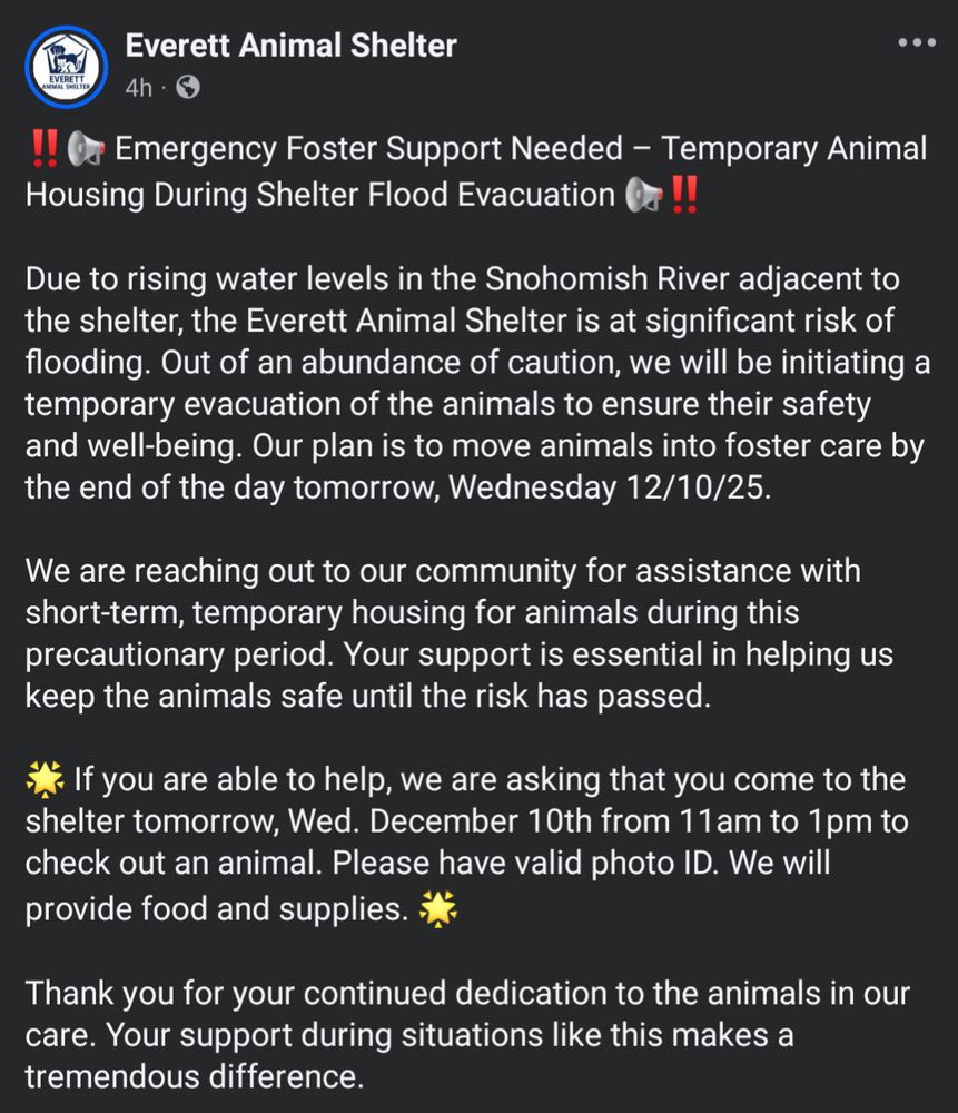
🚨🚨🚨 Everett Animal Shelter is looking for short-term fosters during shelter flood evacuation.
✴️ If interested, please go to EAS (333 Smith Island Rd, Everett, WA 98201) tomorrow between 11-1 w/ valid photo ID
✴️ EAS will provide food & supplies
✴️ Please share with folks in the greater Seattle area
✴️ If interested, please go to EAS (333 Smith Island Rd, Everett, WA 98201) tomorrow between 11-1 w/ valid photo ID
✴️ EAS will provide food & supplies
✴️ Please share with folks in the greater Seattle area

December 10, 2025 at 7:44 AM
🚨🚨🚨 Everett Animal Shelter is looking for short-term fosters during shelter flood evacuation.
✴️ If interested, please go to EAS (333 Smith Island Rd, Everett, WA 98201) tomorrow between 11-1 w/ valid photo ID
✴️ EAS will provide food & supplies
✴️ Please share with folks in the greater Seattle area
✴️ If interested, please go to EAS (333 Smith Island Rd, Everett, WA 98201) tomorrow between 11-1 w/ valid photo ID
✴️ EAS will provide food & supplies
✴️ Please share with folks in the greater Seattle area
Wednesday 8:30am updates:
Welcome back to the winds, this means an increased risk of tree failure and power outages as we continue to deal with the atmospheric river here in Western Washington and Oregon.
ALL of Western Washington is under Flood Watch to Flood Warning at this time with-
Welcome back to the winds, this means an increased risk of tree failure and power outages as we continue to deal with the atmospheric river here in Western Washington and Oregon.
ALL of Western Washington is under Flood Watch to Flood Warning at this time with-
#kiraposting Weather Alert 🧵
PNW folks (WA, BC, OR, and NorCal), we're about to get smacked with a megastorm that'll drop roughly a month+'s worth of rain on us over the course of a week to a week and a half.
Landslides, flooding (rivers, creeks, and streets) is going to happen. Trees may-
PNW folks (WA, BC, OR, and NorCal), we're about to get smacked with a megastorm that'll drop roughly a month+'s worth of rain on us over the course of a week to a week and a half.
Landslides, flooding (rivers, creeks, and streets) is going to happen. Trees may-
December 10, 2025 at 4:47 PM
Wednesday 8:30am updates:
Welcome back to the winds, this means an increased risk of tree failure and power outages as we continue to deal with the atmospheric river here in Western Washington and Oregon.
ALL of Western Washington is under Flood Watch to Flood Warning at this time with-
Welcome back to the winds, this means an increased risk of tree failure and power outages as we continue to deal with the atmospheric river here in Western Washington and Oregon.
ALL of Western Washington is under Flood Watch to Flood Warning at this time with-
If you are in the 100 year flood plain in Skagit County, live along the Skagit and Samish rivers, please know you are in a level 2 (GET READY) evacuation zone and will likely be kicked up to level 3 (GO!).
Flooding is expected to peak on Thursday at this time.
Flooding is expected to peak on Thursday at this time.
Skagit County, esp Auburn, WA, you both are looking at some severe flooding. Skagit River is slated to be a once in 100 years level and currently projected to hit 47ft.
Rsources for information:
www.skagitcounty.net/Departments/...
Rsources for information:
www.skagitcounty.net/Departments/...
Access Skagit County
www.skagitcounty.net
December 10, 2025 at 4:36 PM
If you are in the 100 year flood plain in Skagit County, live along the Skagit and Samish rivers, please know you are in a level 2 (GET READY) evacuation zone and will likely be kicked up to level 3 (GO!).
Flooding is expected to peak on Thursday at this time.
Flooding is expected to peak on Thursday at this time.
fandom, writing, maybe art, etc posts will return maybe Saturday-ish. I'm in message + storm tracker mode and that takes priority given the circumstances.
If you have friends in Washington State especially, please repost, etc the information as I post to get it out to anyone else who may need it.
If you have friends in Washington State especially, please repost, etc the information as I post to get it out to anyone else who may need it.
December 10, 2025 at 7:45 AM
fandom, writing, maybe art, etc posts will return maybe Saturday-ish. I'm in message + storm tracker mode and that takes priority given the circumstances.
If you have friends in Washington State especially, please repost, etc the information as I post to get it out to anyone else who may need it.
If you have friends in Washington State especially, please repost, etc the information as I post to get it out to anyone else who may need it.
URGENT UPDATE:
an evacuation alert has been sent out for the Ebey Island area of Snohomish County, where major flooding is expected due to the dikes likely being overtopped by the floodwaters.
In addition to this, the Three Rivers Mobile Home Park is being evacuated.
an evacuation alert has been sent out for the Ebey Island area of Snohomish County, where major flooding is expected due to the dikes likely being overtopped by the floodwaters.
In addition to this, the Three Rivers Mobile Home Park is being evacuated.
#kiraposting Weather Alert 🧵
PNW folks (WA, BC, OR, and NorCal), we're about to get smacked with a megastorm that'll drop roughly a month+'s worth of rain on us over the course of a week to a week and a half.
Landslides, flooding (rivers, creeks, and streets) is going to happen. Trees may-
PNW folks (WA, BC, OR, and NorCal), we're about to get smacked with a megastorm that'll drop roughly a month+'s worth of rain on us over the course of a week to a week and a half.
Landslides, flooding (rivers, creeks, and streets) is going to happen. Trees may-
December 10, 2025 at 7:10 AM
URGENT UPDATE:
an evacuation alert has been sent out for the Ebey Island area of Snohomish County, where major flooding is expected due to the dikes likely being overtopped by the floodwaters.
In addition to this, the Three Rivers Mobile Home Park is being evacuated.
an evacuation alert has been sent out for the Ebey Island area of Snohomish County, where major flooding is expected due to the dikes likely being overtopped by the floodwaters.
In addition to this, the Three Rivers Mobile Home Park is being evacuated.
9pm PST rivers:
Nooksack River at Saxon Bridge, North Cedarville + Ferndale: Major to record flooding expected.
Samish River near Burlington:
Forecasted to break the record for major flooding + likely results in Samish Island cut off from mainland access. Levees look to overtop + could breach.
Nooksack River at Saxon Bridge, North Cedarville + Ferndale: Major to record flooding expected.
Samish River near Burlington:
Forecasted to break the record for major flooding + likely results in Samish Island cut off from mainland access. Levees look to overtop + could breach.
Projected to hit Major Flood Status 🧵:
WA Rivers:
Skykomish near Gold Bard
Skagit near Concrete and Mt Vernon
Snohomish (by said city)
Snoqualmie near Carnation and Snoqualmie Falls
White near St Auburn
Nisqually near National
Cowlitz near Randle and Packwood
Grays near Rosburg (already at 31ft)
WA Rivers:
Skykomish near Gold Bard
Skagit near Concrete and Mt Vernon
Snohomish (by said city)
Snoqualmie near Carnation and Snoqualmie Falls
White near St Auburn
Nisqually near National
Cowlitz near Randle and Packwood
Grays near Rosburg (already at 31ft)
Update from 11:30am PDT:
Rivers, Streams, Creeks draining from:
Forecast rain amounts reach 6 to 12 inches in the Cascades, Cascade foothills, Coast Range and the coast.
Swift Reservoir + Cascade Locks areas, I am looking at you specifically w/ rain totals forecast to be in the double digits (10+)
Rivers, Streams, Creeks draining from:
Forecast rain amounts reach 6 to 12 inches in the Cascades, Cascade foothills, Coast Range and the coast.
Swift Reservoir + Cascade Locks areas, I am looking at you specifically w/ rain totals forecast to be in the double digits (10+)
December 10, 2025 at 5:33 AM
9pm PST rivers:
Nooksack River at Saxon Bridge, North Cedarville + Ferndale: Major to record flooding expected.
Samish River near Burlington:
Forecasted to break the record for major flooding + likely results in Samish Island cut off from mainland access. Levees look to overtop + could breach.
Nooksack River at Saxon Bridge, North Cedarville + Ferndale: Major to record flooding expected.
Samish River near Burlington:
Forecasted to break the record for major flooding + likely results in Samish Island cut off from mainland access. Levees look to overtop + could breach.
Reposted by Kireon @ Life™


October 19, 2024 at 9:30 PM
Reposted by Kireon @ Life™

Opening 3 half-body slots, line art, they can be claimed at once for a paired artwork. $50 for 1 slot. Deadline — 1 month
💳 via Boosty or Hipolink, any humanoid characters, no refounds
Send any emoji to be added to the ping list here
#commissionsoopen #art
💳 via Boosty or Hipolink, any humanoid characters, no refounds
Send any emoji to be added to the ping list here
#commissionsoopen #art


December 5, 2025 at 7:43 AM
Opening 3 half-body slots, line art, they can be claimed at once for a paired artwork. $50 for 1 slot. Deadline — 1 month
💳 via Boosty or Hipolink, any humanoid characters, no refounds
Send any emoji to be added to the ping list here
#commissionsoopen #art
💳 via Boosty or Hipolink, any humanoid characters, no refounds
Send any emoji to be added to the ping list here
#commissionsoopen #art
Reposted by Kireon @ Life™
UPDATE as of 2:30pm PST with Round 2 expected to hit tonight into Wednesday:
WA Rivers at Major/Moderate Flood Stage 1/2
Elwha at McDonald Bridge + Elwha River
Stillaguamish at Arlington
Cedar at Landsburg
Pullyap at Orting
Nooksack at Ferndale + North Cedarville
S Fork Nooksack at Saxon Bridge
WA Rivers at Major/Moderate Flood Stage 1/2
Elwha at McDonald Bridge + Elwha River
Stillaguamish at Arlington
Cedar at Landsburg
Pullyap at Orting
Nooksack at Ferndale + North Cedarville
S Fork Nooksack at Saxon Bridge
December 10, 2025 at 12:06 AM
UPDATE as of 2:30pm PST with Round 2 expected to hit tonight into Wednesday:
WA Rivers at Major/Moderate Flood Stage 1/2
Elwha at McDonald Bridge + Elwha River
Stillaguamish at Arlington
Cedar at Landsburg
Pullyap at Orting
Nooksack at Ferndale + North Cedarville
S Fork Nooksack at Saxon Bridge
WA Rivers at Major/Moderate Flood Stage 1/2
Elwha at McDonald Bridge + Elwha River
Stillaguamish at Arlington
Cedar at Landsburg
Pullyap at Orting
Nooksack at Ferndale + North Cedarville
S Fork Nooksack at Saxon Bridge
Reposted by Kireon @ Life™

Genuinely, please stop demonizing artists who forget to or are too exhausted to write out detailed alt text descriptions. It's not helping anyone. We often have disabilities too. We are not personally or purposefully attacking the visually impaired. Try to be considerate.
December 9, 2025 at 2:14 PM
Genuinely, please stop demonizing artists who forget to or are too exhausted to write out detailed alt text descriptions. It's not helping anyone. We often have disabilities too. We are not personally or purposefully attacking the visually impaired. Try to be considerate.
LRP: Lyna they can never make me hate or forget you 😭
December 9, 2025 at 8:37 PM
LRP: Lyna they can never make me hate or forget you 😭
Reposted by Kireon @ Life™

Lyna: I…am fine…
Completely… and utterly…fine! Better than fine! Hale and hearty and still alive to mourn those who are not. Who I failed to protect when they needed me most.
Completely… and utterly…fine! Better than fine! Hale and hearty and still alive to mourn those who are not. Who I failed to protect when they needed me most.
December 9, 2025 at 4:10 PM
Lyna: I…am fine…
Completely… and utterly…fine! Better than fine! Hale and hearty and still alive to mourn those who are not. Who I failed to protect when they needed me most.
Completely… and utterly…fine! Better than fine! Hale and hearty and still alive to mourn those who are not. Who I failed to protect when they needed me most.
Reposted by Kireon @ Life™

Hey remember that whole "Bluesky doesn't have algorithms" thing
October 31, 2025 at 11:13 PM
Hey remember that whole "Bluesky doesn't have algorithms" thing
Reposted by Kireon @ Life™

Heads up for all my art friends that have an online store.

December 9, 2025 at 4:39 PM
Heads up for all my art friends that have an online store.
Reposted by Kireon @ Life™

GOOD NEWS! Researchers have developed a cancer vaccine that has shown STUNNING results, PREVENTING up to 88% of MULTIPLE aggressive cancers by harnessing dual-pathway nanoparticles that train the immune system to recognize and destroy tumor cells. In some cases, it COMPLETELY prevented metastasis.
December 9, 2025 at 5:00 PM
GOOD NEWS! Researchers have developed a cancer vaccine that has shown STUNNING results, PREVENTING up to 88% of MULTIPLE aggressive cancers by harnessing dual-pathway nanoparticles that train the immune system to recognize and destroy tumor cells. In some cases, it COMPLETELY prevented metastasis.
Reposted by Kireon @ Life™


December 9, 2025 at 4:26 PM