


Antonio Antoine
@aasmith.bsky.social
This simple label took me over day to make. I am still learning expression builder in #QGIS. I needed the highest value for each feature from over one hundred attribute columns AND the name of the field name. The worst part is I don't know if I will use this info. lol

![Screenshot of QGIS showing the expression to find the highest value from a range of fields. The code reads as:
concat( "PARKNAME", '/',map_akeys(attributes())[array_find(map_avals(attributes()), array_max(array_slice(map_avals(attributes()), 10, 148)))], '/' , array_max(array_slice(map_avals(attributes()), 10, 148)))](https://cdn.bsky.app/img/feed_thumbnail/plain/did:plc:vxgrriczkvh2dojfuogcju2n/bafkreibba47gbphqr5oufxcsf7mw23rpzgdgnx2oowf3g5pvyeh5ue2ueu@jpeg)
January 15, 2026 at 8:54 PM
This simple label took me over day to make. I am still learning expression builder in #QGIS. I needed the highest value for each feature from over one hundred attribute columns AND the name of the field name. The worst part is I don't know if I will use this info. lol
A work-in-progress map of the Forests in the lower US. I haven't decided if I am going to display and label the National Parks and/or Forests yet. Things get pretty busy on the West Coast.
The legend is going to be a nightmare and I am not looking forward to it. 😂
#gis #gischat #cartography #map
The legend is going to be a nightmare and I am not looking forward to it. 😂
#gis #gischat #cartography #map

January 9, 2026 at 6:32 PM
A work-in-progress map of the Forests in the lower US. I haven't decided if I am going to display and label the National Parks and/or Forests yet. Things get pretty busy on the West Coast.
The legend is going to be a nightmare and I am not looking forward to it. 😂
#gis #gischat #cartography #map
The legend is going to be a nightmare and I am not looking forward to it. 😂
#gis #gischat #cartography #map
This is an earlier version where the gradient was applied to the whole feature layer. I liked it, but the Grand Canyon didn't look so grand.

January 2, 2026 at 4:22 PM
This is an earlier version where the gradient was applied to the whole feature layer. I liked it, but the Grand Canyon didn't look so grand.
Arizona Joy Plot Map
Testing out another method. Instead of applying the gradient across the entire feature layer, I applied a gradient to each individual plot line. This gives the plot lines a more 3D like effect. This is still a work in progress.
#gis #qgis #cartography #maps
Testing out another method. Instead of applying the gradient across the entire feature layer, I applied a gradient to each individual plot line. This gives the plot lines a more 3D like effect. This is still a work in progress.
#gis #qgis #cartography #maps

January 2, 2026 at 4:22 PM
Arizona Joy Plot Map
Testing out another method. Instead of applying the gradient across the entire feature layer, I applied a gradient to each individual plot line. This gives the plot lines a more 3D like effect. This is still a work in progress.
#gis #qgis #cartography #maps
Testing out another method. Instead of applying the gradient across the entire feature layer, I applied a gradient to each individual plot line. This gives the plot lines a more 3D like effect. This is still a work in progress.
#gis #qgis #cartography #maps
Today is the Winter Solstice, the longest night of the year for most of us living between the Equator and the Arctic Circle. The duration varies by latitude. Those living in the Arctic are experiencing Polar Night, which may have begun weeks ago!
Blog
antonioantoine.com/2025/12/17/t...
Blog
antonioantoine.com/2025/12/17/t...

December 21, 2025 at 3:48 PM
Today is the Winter Solstice, the longest night of the year for most of us living between the Equator and the Arctic Circle. The duration varies by latitude. Those living in the Arctic are experiencing Polar Night, which may have begun weeks ago!
Blog
antonioantoine.com/2025/12/17/t...
Blog
antonioantoine.com/2025/12/17/t...
I moved on Washington. I don't think we can clip off the little extensions beyond the state border and keep the background effect. I made some additional adjustments in Affinity Designer. This one looks bad in the preview, but is cleaner in the full-size version.
#cartography #gis #qgis #gischat
#cartography #gis #qgis #gischat

December 18, 2025 at 6:39 PM
I moved on Washington. I don't think we can clip off the little extensions beyond the state border and keep the background effect. I made some additional adjustments in Affinity Designer. This one looks bad in the preview, but is cleaner in the full-size version.
#cartography #gis #qgis #gischat
#cartography #gis #qgis #gischat
Got my #NACIS Christmas tree ornament up! I think it is the only mappy ornament I have and I happened to win it at the 2025 conference.

December 18, 2025 at 1:41 PM
Got my #NACIS Christmas tree ornament up! I think it is the only mappy ornament I have and I happened to win it at the 2025 conference.
I can extrude the joy lines to fix the streaks, but I lose the displacement effect I was going for. I am going to play around with geometry generator for a bit to see if I can figure something out.

December 17, 2025 at 4:42 PM
I can extrude the joy lines to fix the streaks, but I lose the displacement effect I was going for. I am going to play around with geometry generator for a bit to see if I can figure something out.
I already hit a snag. TN is long and narrow, with the Mississippi River on the west and the Appalachian Mountains in the east. The underlying color ramp appears as streaks rather than positive displacement.
#qgis #gischat #cartography
#qgis #gischat #cartography

December 17, 2025 at 4:42 PM
I already hit a snag. TN is long and narrow, with the Mississippi River on the west and the Appalachian Mountains in the east. The underlying color ramp appears as streaks rather than positive displacement.
#qgis #gischat #cartography
#qgis #gischat #cartography
I am thinking about doing a state-level run of Joy Plot maps. I do think Virginia may have set the bar a little high. It looks like a mountain emerging from the fog.
#cartography #maps #qgis #gis
#cartography #maps #qgis #gis

December 15, 2025 at 3:00 PM
I am thinking about doing a state-level run of Joy Plot maps. I do think Virginia may have set the bar a little high. It looks like a mountain emerging from the fog.
#cartography #maps #qgis #gis
#cartography #maps #qgis #gis
The #30DayMapChallenge is a wrap! I made a map quilt of my favorite Rhode Island maps from the challenge. I had to resize a few of them to get them all to line up. Had I planned this in advance, I would have alternated between light and dark maps.
#cartography
#cartography

December 10, 2025 at 5:28 PM
The #30DayMapChallenge is a wrap! I made a map quilt of my favorite Rhode Island maps from the challenge. I had to resize a few of them to get them all to line up. Had I planned this in advance, I would have alternated between light and dark maps.
#cartography
#cartography
I got maps to make, but the second shingles shot is kicking my ass. 🤒 Vaccines usually are pretty mild for me.
I don't have Spotify, but YouTube Music is trying to embarrass me with my listening habits of 2024. I am not sure how Draggin Around was my top song. lol. Everything else makes sense.
I don't have Spotify, but YouTube Music is trying to embarrass me with my listening habits of 2024. I am not sure how Draggin Around was my top song. lol. Everything else makes sense.

December 3, 2025 at 6:58 PM
I got maps to make, but the second shingles shot is kicking my ass. 🤒 Vaccines usually are pretty mild for me.
I don't have Spotify, but YouTube Music is trying to embarrass me with my listening habits of 2024. I am not sure how Draggin Around was my top song. lol. Everything else makes sense.
I don't have Spotify, but YouTube Music is trying to embarrass me with my listening habits of 2024. I am not sure how Draggin Around was my top song. lol. Everything else makes sense.
Day 29 - Raster
Rhode Island 24K Topo Maps
I have wanted to make a version of this map for some years now. TopoView was a big help in downloading the 24k topos. Clipping and stitching the 38 topos was a pita even with batch processing. I crashed QGIS a few times. lol
#30DayMapChallenge
Rhode Island 24K Topo Maps
I have wanted to make a version of this map for some years now. TopoView was a big help in downloading the 24k topos. Clipping and stitching the 38 topos was a pita even with batch processing. I crashed QGIS a few times. lol
#30DayMapChallenge

November 29, 2025 at 8:09 PM
Day 29 - Raster
Rhode Island 24K Topo Maps
I have wanted to make a version of this map for some years now. TopoView was a big help in downloading the 24k topos. Clipping and stitching the 38 topos was a pita even with batch processing. I crashed QGIS a few times. lol
#30DayMapChallenge
Rhode Island 24K Topo Maps
I have wanted to make a version of this map for some years now. TopoView was a big help in downloading the 24k topos. Clipping and stitching the 38 topos was a pita even with batch processing. I crashed QGIS a few times. lol
#30DayMapChallenge
Day 28 - Black
The Longest Nights (2025)
Polar night (+24 hr night) occurs just beyond the Arctic Circle. This is due to the Earth's gravitational pull on light. The ramp up from just beyond the Arctic Circle 67.4°N (24 hrs) to 67.5°N (11 days) is wild.
#30DayMapChallenge
The Longest Nights (2025)
Polar night (+24 hr night) occurs just beyond the Arctic Circle. This is due to the Earth's gravitational pull on light. The ramp up from just beyond the Arctic Circle 67.4°N (24 hrs) to 67.5°N (11 days) is wild.
#30DayMapChallenge

November 28, 2025 at 9:33 PM
Day 28 - Black
The Longest Nights (2025)
Polar night (+24 hr night) occurs just beyond the Arctic Circle. This is due to the Earth's gravitational pull on light. The ramp up from just beyond the Arctic Circle 67.4°N (24 hrs) to 67.5°N (11 days) is wild.
#30DayMapChallenge
The Longest Nights (2025)
Polar night (+24 hr night) occurs just beyond the Arctic Circle. This is due to the Earth's gravitational pull on light. The ramp up from just beyond the Arctic Circle 67.4°N (24 hrs) to 67.5°N (11 days) is wild.
#30DayMapChallenge
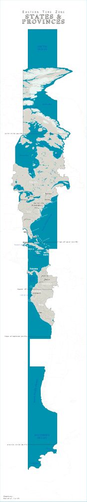
Day 27 - Boundaries
EST States & Provinces
How many states and provinces share the same time zone as Rhode Island?
#30DayMapChallenge
EST States & Provinces
How many states and provinces share the same time zone as Rhode Island?
#30DayMapChallenge
November 27, 2025 at 6:58 PM
Day 27 - Boundaries
EST States & Provinces
How many states and provinces share the same time zone as Rhode Island?
#30DayMapChallenge
EST States & Provinces
How many states and provinces share the same time zone as Rhode Island?
#30DayMapChallenge
Day 26 - Transport
Rhode Island Bike Lanes & Routes
I am not super happy with this one (don't hate either). I think it needs to bake for a few more hours. Maybe even a total redo. However, I am running low on time and creative energy. And this isn't my normal lane, lol.
#30DayMapChallenge
Rhode Island Bike Lanes & Routes
I am not super happy with this one (don't hate either). I think it needs to bake for a few more hours. Maybe even a total redo. However, I am running low on time and creative energy. And this isn't my normal lane, lol.
#30DayMapChallenge

November 26, 2025 at 9:51 PM
Day 26 - Transport
Rhode Island Bike Lanes & Routes
I am not super happy with this one (don't hate either). I think it needs to bake for a few more hours. Maybe even a total redo. However, I am running low on time and creative energy. And this isn't my normal lane, lol.
#30DayMapChallenge
Rhode Island Bike Lanes & Routes
I am not super happy with this one (don't hate either). I think it needs to bake for a few more hours. Maybe even a total redo. However, I am running low on time and creative energy. And this isn't my normal lane, lol.
#30DayMapChallenge
I remember reading this a while ago, but the Google AI disagreed. The article above is over 10 years old, but the articles it sourced don't support its answer. 😐
But I digress.
But I digress.

November 25, 2025 at 8:53 PM
I remember reading this a while ago, but the Google AI disagreed. The article above is over 10 years old, but the articles it sourced don't support its answer. 😐
But I digress.
But I digress.
Day 25 - Hexagons
Rhode Island Dating Age Population Distribution
I have been thinking about making a national version of this map for some time now. The hue indicates whether a cell has more men or women (age 20-39). The hex size shows the cell pop density per 1 km (0.6 mi).
#30DayMapChallenge
Rhode Island Dating Age Population Distribution
I have been thinking about making a national version of this map for some time now. The hue indicates whether a cell has more men or women (age 20-39). The hex size shows the cell pop density per 1 km (0.6 mi).
#30DayMapChallenge

November 25, 2025 at 8:53 PM
Day 25 - Hexagons
Rhode Island Dating Age Population Distribution
I have been thinking about making a national version of this map for some time now. The hue indicates whether a cell has more men or women (age 20-39). The hex size shows the cell pop density per 1 km (0.6 mi).
#30DayMapChallenge
Rhode Island Dating Age Population Distribution
I have been thinking about making a national version of this map for some time now. The hue indicates whether a cell has more men or women (age 20-39). The hex size shows the cell pop density per 1 km (0.6 mi).
#30DayMapChallenge
Day 24 - Toponymy
Rhode Island Indigenous Toponymy
This map shows the places (cities, towns, and villages) in Rhode Island named after Indigenous people, places, or things, along with their meanings.
#30DayMapChallenge
Rhode Island Indigenous Toponymy
This map shows the places (cities, towns, and villages) in Rhode Island named after Indigenous people, places, or things, along with their meanings.
#30DayMapChallenge

November 25, 2025 at 2:28 AM
Day 24 - Toponymy
Rhode Island Indigenous Toponymy
This map shows the places (cities, towns, and villages) in Rhode Island named after Indigenous people, places, or things, along with their meanings.
#30DayMapChallenge
Rhode Island Indigenous Toponymy
This map shows the places (cities, towns, and villages) in Rhode Island named after Indigenous people, places, or things, along with their meanings.
#30DayMapChallenge
Day 22 - Natural Earth (NE)
Antarctica
Taking a small break from Rhode Island today for a map of Antarctica. Most NE data is intended for medium to small-scale maps, so I wanted a subject area that was a little larger. All layers are vector data from NE.
#30DayMapChallenge
Antarctica
Taking a small break from Rhode Island today for a map of Antarctica. Most NE data is intended for medium to small-scale maps, so I wanted a subject area that was a little larger. All layers are vector data from NE.
#30DayMapChallenge

November 22, 2025 at 10:46 PM
Day 22 - Natural Earth (NE)
Antarctica
Taking a small break from Rhode Island today for a map of Antarctica. Most NE data is intended for medium to small-scale maps, so I wanted a subject area that was a little larger. All layers are vector data from NE.
#30DayMapChallenge
Antarctica
Taking a small break from Rhode Island today for a map of Antarctica. Most NE data is intended for medium to small-scale maps, so I wanted a subject area that was a little larger. All layers are vector data from NE.
#30DayMapChallenge
Day 21 - Icon
Rhode Island Public Libraries
Here are the Public Libraries across Rhode Island. The symbol is from the @nounproject.bsky.social, which is probably one of the best subscriptions I have. The symbols are graduated by square footage.
#30DayMapChallenge
Rhode Island Public Libraries
Here are the Public Libraries across Rhode Island. The symbol is from the @nounproject.bsky.social, which is probably one of the best subscriptions I have. The symbols are graduated by square footage.
#30DayMapChallenge

November 21, 2025 at 3:01 PM
Day 21 - Icon
Rhode Island Public Libraries
Here are the Public Libraries across Rhode Island. The symbol is from the @nounproject.bsky.social, which is probably one of the best subscriptions I have. The symbols are graduated by square footage.
#30DayMapChallenge
Rhode Island Public Libraries
Here are the Public Libraries across Rhode Island. The symbol is from the @nounproject.bsky.social, which is probably one of the best subscriptions I have. The symbols are graduated by square footage.
#30DayMapChallenge
Day 20 - Water
Narragansett Bay Watershed
10 Days to go! I am starting to feel a little repetitive. 😰 The bathymetry saved this one.
Almost all of Rhode Island is in the Narragansett Bay Watershed. I think I will expand this one into a large format map one day.
#30DayMapChallenge
Narragansett Bay Watershed
10 Days to go! I am starting to feel a little repetitive. 😰 The bathymetry saved this one.
Almost all of Rhode Island is in the Narragansett Bay Watershed. I think I will expand this one into a large format map one day.
#30DayMapChallenge

November 20, 2025 at 6:52 PM
Day 20 - Water
Narragansett Bay Watershed
10 Days to go! I am starting to feel a little repetitive. 😰 The bathymetry saved this one.
Almost all of Rhode Island is in the Narragansett Bay Watershed. I think I will expand this one into a large format map one day.
#30DayMapChallenge
Narragansett Bay Watershed
10 Days to go! I am starting to feel a little repetitive. 😰 The bathymetry saved this one.
Almost all of Rhode Island is in the Narragansett Bay Watershed. I think I will expand this one into a large format map one day.
#30DayMapChallenge
Day 19 - Projections
Rhode Island Projections
All caught up!
I wanted to compare a few projections I have tried with my Rhode Island maps. These projections are centered on Providence, similar to @kennethkhw.bsky.social map.
#30DayMapChallenge
Rhode Island Projections
All caught up!
I wanted to compare a few projections I have tried with my Rhode Island maps. These projections are centered on Providence, similar to @kennethkhw.bsky.social map.
#30DayMapChallenge

November 19, 2025 at 9:14 PM
Day 19 - Projections
Rhode Island Projections
All caught up!
I wanted to compare a few projections I have tried with my Rhode Island maps. These projections are centered on Providence, similar to @kennethkhw.bsky.social map.
#30DayMapChallenge
Rhode Island Projections
All caught up!
I wanted to compare a few projections I have tried with my Rhode Island maps. These projections are centered on Providence, similar to @kennethkhw.bsky.social map.
#30DayMapChallenge
Day 18 - Out of This World
Sea of Tranquility Apollo Lunar Landings
Technically, there is just the one Apollo mission in the Mare Tranquilitus, but the others are in the extent. Fun fact: I grew up in the Rocket City, and I was born on the anniversary of a lunar landing.
#30DayMapChallenge
Sea of Tranquility Apollo Lunar Landings
Technically, there is just the one Apollo mission in the Mare Tranquilitus, but the others are in the extent. Fun fact: I grew up in the Rocket City, and I was born on the anniversary of a lunar landing.
#30DayMapChallenge

November 19, 2025 at 2:59 PM
Day 18 - Out of This World
Sea of Tranquility Apollo Lunar Landings
Technically, there is just the one Apollo mission in the Mare Tranquilitus, but the others are in the extent. Fun fact: I grew up in the Rocket City, and I was born on the anniversary of a lunar landing.
#30DayMapChallenge
Sea of Tranquility Apollo Lunar Landings
Technically, there is just the one Apollo mission in the Mare Tranquilitus, but the others are in the extent. Fun fact: I grew up in the Rocket City, and I was born on the anniversary of a lunar landing.
#30DayMapChallenge
Day 17 - A New Tool
Rhode Island Hillshade
I am a day or two behind now. I finally got #Rayshader installed; it was a whole ordeal. This map is nothing crazy. Just a hillshade of Rhode Island that I annotated in #AffinityDesigner.
#30DayMapChallenge
Rhode Island Hillshade
I am a day or two behind now. I finally got #Rayshader installed; it was a whole ordeal. This map is nothing crazy. Just a hillshade of Rhode Island that I annotated in #AffinityDesigner.
#30DayMapChallenge

November 19, 2025 at 2:49 AM
Day 17 - A New Tool
Rhode Island Hillshade
I am a day or two behind now. I finally got #Rayshader installed; it was a whole ordeal. This map is nothing crazy. Just a hillshade of Rhode Island that I annotated in #AffinityDesigner.
#30DayMapChallenge
Rhode Island Hillshade
I am a day or two behind now. I finally got #Rayshader installed; it was a whole ordeal. This map is nothing crazy. Just a hillshade of Rhode Island that I annotated in #AffinityDesigner.
#30DayMapChallenge