


Mattzk41
@mattzt.bsky.social
Weather enthusiast observer report on natural disasters and extreme weather events effecting the sw u.s socal especially high desert areas. ✝️🌥🌦
Reposted by Mattzk41

A longer and more detailed look at the Sword of Orion. #Astronomy #Astrophotography

January 17, 2026 at 8:47 PM
A longer and more detailed look at the Sword of Orion. #Astronomy #Astrophotography
Reposted by Mattzk41

In California, folks may recognize this rather striking temperature pattern from Nov, with warmer than average temperatures everywhere but Central Valley. You guessed it: tule fog will likely return, at least a times, this week. BUT... it likely won't be as persistent as Nov.

January 11, 2026 at 11:13 PM
In California, folks may recognize this rather striking temperature pattern from Nov, with warmer than average temperatures everywhere but Central Valley. You guessed it: tule fog will likely return, at least a times, this week. BUT... it likely won't be as persistent as Nov.
Reposted by Mattzk41

Looking ahead to next week - A Ridge of High Pressure will dominate the West Coast, with temperatures warming into the upper 70's across #SoCal Metro areas by midweek, with some Valley locations into the 80's. West Coast Ridging will persist through at least the 20th of the month. #CAwx

January 9, 2026 at 11:03 PM
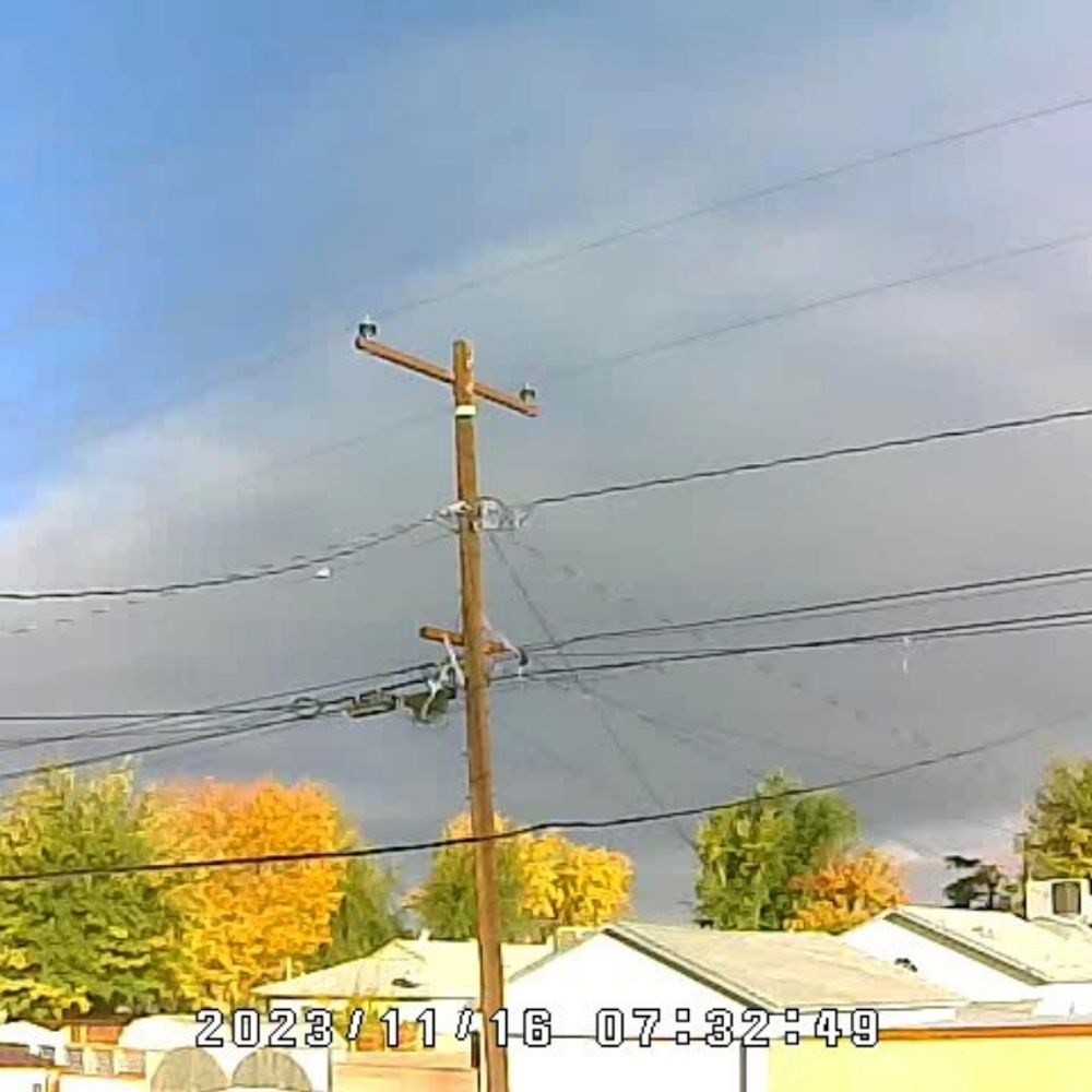
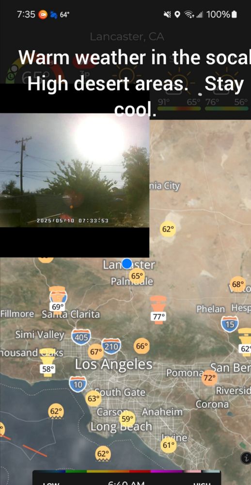
My sister took this ya been wild beginning of 2026. Rain clouds. High desert Lancaster ca.

January 4, 2026 at 7:11 PM
My sister took this ya been wild beginning of 2026. Rain clouds. High desert Lancaster ca.
Reposted by Mattzk41
This should cheer you up 😅
#roadrunner
#roadrunner

Wonder why this scene looks so familiar...
#WildlifeWednesday 🐦🐕
#WildlifeWednesday 🐦🐕
November 17, 2025 at 7:31 PM
This should cheer you up 😅
#roadrunner
#roadrunner
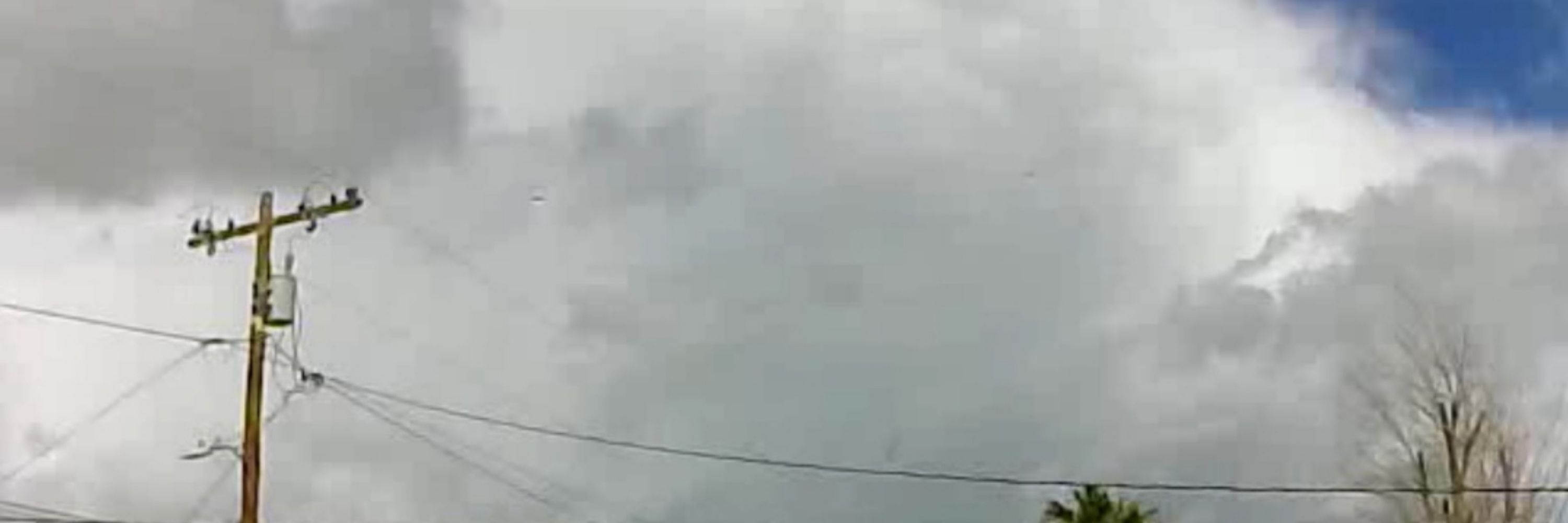
Rain for socal coming possible 1-3 inches in high desert areas higher in foothills.


November 12, 2025 at 11:26 PM
Rain for socal coming possible 1-3 inches in high desert areas higher in foothills.

Reposted by Mattzk41
NWS National Hurricane Center Miami FL
500 AM PDT Wed Oct 8 2025
For the eastern and central North Pacific east of 180 longitude:
Active Systems:
The National Hurricane Center is issuing advisories on Tropical
Storm Octave, located well southwest of the southern tip of the Baja
California Penins
500 AM PDT Wed Oct 8 2025
For the eastern and central North Pacific east of 180 longitude:
Active Systems:
The National Hurricane Center is issuing advisories on Tropical
Storm Octave, located well southwest of the southern tip of the Baja
California Penins


October 8, 2025 at 12:15 PM
NWS National Hurricane Center Miami FL
500 AM PDT Wed Oct 8 2025
For the eastern and central North Pacific east of 180 longitude:
Active Systems:
The National Hurricane Center is issuing advisories on Tropical
Storm Octave, located well southwest of the southern tip of the Baja
California Penins
500 AM PDT Wed Oct 8 2025
For the eastern and central North Pacific east of 180 longitude:
Active Systems:
The National Hurricane Center is issuing advisories on Tropical
Storm Octave, located well southwest of the southern tip of the Baja
California Penins
Reposted by Mattzk41
NWS National Hurricane Center Miami FL
500 PM PDT Tue Sep 16 2025
For the eastern and central North Pacific east of 180 longitude:
Active Systems:
The National Hurricane Center is issuing advisories on Tropical
Depression Mario, located several hundred miles west of the southern
tip of the Baja
500 PM PDT Tue Sep 16 2025
For the eastern and central North Pacific east of 180 longitude:
Active Systems:
The National Hurricane Center is issuing advisories on Tropical
Depression Mario, located several hundred miles west of the southern
tip of the Baja


September 17, 2025 at 12:34 AM
NWS National Hurricane Center Miami FL
500 PM PDT Tue Sep 16 2025
For the eastern and central North Pacific east of 180 longitude:
Active Systems:
The National Hurricane Center is issuing advisories on Tropical
Depression Mario, located several hundred miles west of the southern
tip of the Baja
500 PM PDT Tue Sep 16 2025
For the eastern and central North Pacific east of 180 longitude:
Active Systems:
The National Hurricane Center is issuing advisories on Tropical
Depression Mario, located several hundred miles west of the southern
tip of the Baja
Reposted by Mattzk41
NAM Satellite Depiction - Subtropical Moisture from the remnants of #Mario will be pulled Northward into #SoCal later this week. While rainfall amounts still need to be pinned down, it looks like all locations will see a chance for rain & Thunderstorms between Wednesday and Friday PM. #CAwx
September 15, 2025 at 10:15 PM
Reposted by Mattzk41

NWS National Hurricane Center Miami FL
200 AM EDT Sun Sep 14 2025
For the North Atlantic...Caribbean Sea and the Gulf of Mexico:
200 AM EDT Sun Sep 14 2025
For the North Atlantic...Caribbean Sea and the Gulf of Mexico:


September 14, 2025 at 6:11 AM
NWS National Hurricane Center Miami FL
200 AM EDT Sun Sep 14 2025
For the North Atlantic...Caribbean Sea and the Gulf of Mexico:
200 AM EDT Sun Sep 14 2025
For the North Atlantic...Caribbean Sea and the Gulf of Mexico:
Reposted by Mattzk41
NWS National Hurricane Center Miami FL
500 AM PDT Sun Sep 14 2025
For the eastern and central North Pacific east of 180 longitude:
500 AM PDT Sun Sep 14 2025
For the eastern and central North Pacific east of 180 longitude:


September 14, 2025 at 12:12 PM
NWS National Hurricane Center Miami FL
500 AM PDT Sun Sep 14 2025
For the eastern and central North Pacific east of 180 longitude:
500 AM PDT Sun Sep 14 2025
For the eastern and central North Pacific east of 180 longitude:
Reposted by Mattzk41
Composite Radar as of 12:30pm 9/2/25 - Extensive showers and Thundershowers across Inland locations and local Deserts as a disturbance embedded in the Southerly flow aloft moves through. Showers could pop up anywhere across #SoCal Today, but will be more limited to the Mts/Deserts tomorrow. #CAwx
September 2, 2025 at 7:43 PM
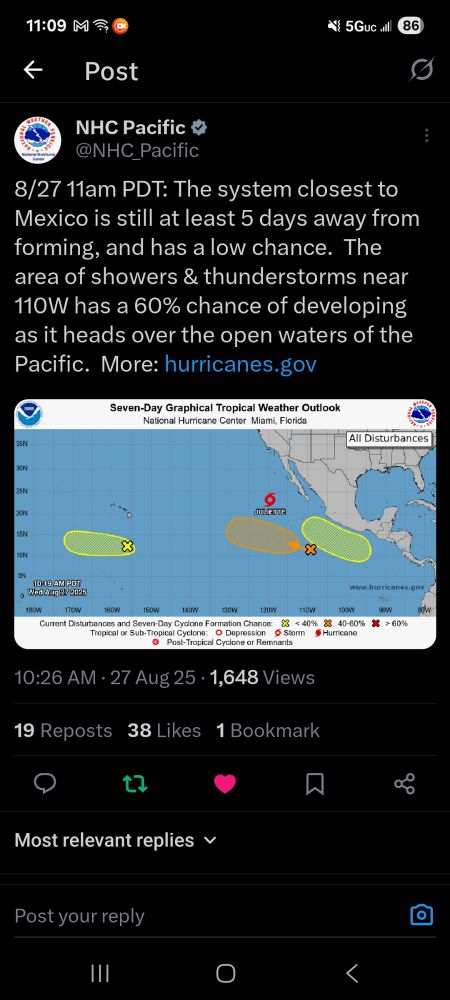
Lots of tropical activity in epac. Drawing up some moisture up into sw us.
August 27, 2025 at 6:13 PM
Lots of tropical activity in epac. Drawing up some moisture up into sw us.
Reposted by Mattzk41
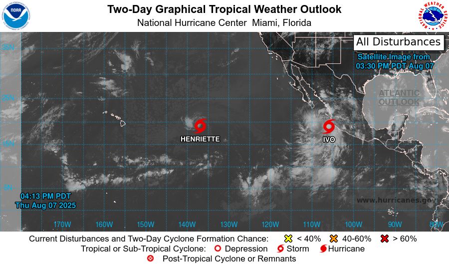
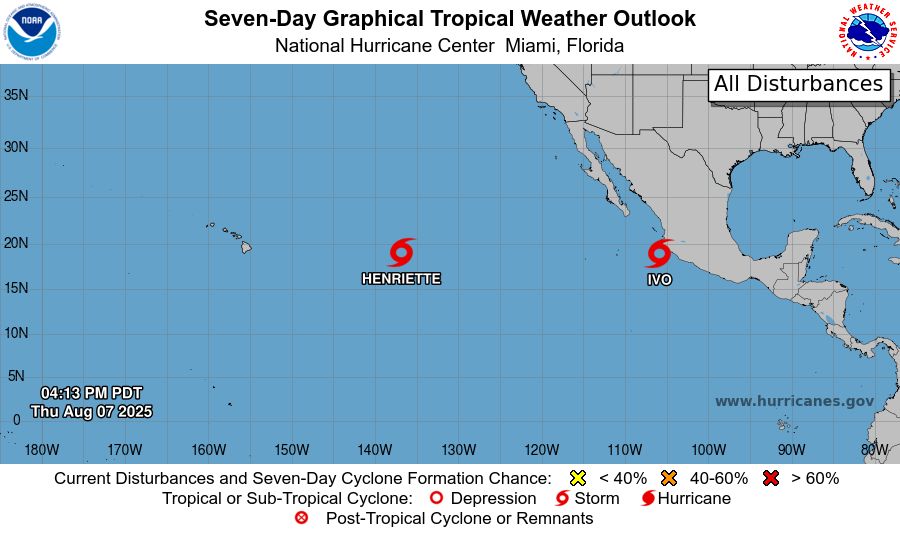
NWS National Hurricane Center Miami FL
500 PM PDT Thu Aug 7 2025
For the eastern and central North Pacific east of 180 longitude:
Active Systems:
The National Hurricane Center is issuing advisories on Tropical
Storm Henriette, located well east of the Hawaiian Islands.
Henriette is expected to
500 PM PDT Thu Aug 7 2025
For the eastern and central North Pacific east of 180 longitude:
Active Systems:
The National Hurricane Center is issuing advisories on Tropical
Storm Henriette, located well east of the Hawaiian Islands.
Henriette is expected to
August 8, 2025 at 12:39 AM
NWS National Hurricane Center Miami FL
500 PM PDT Thu Aug 7 2025
For the eastern and central North Pacific east of 180 longitude:
Active Systems:
The National Hurricane Center is issuing advisories on Tropical
Storm Henriette, located well east of the Hawaiian Islands.
Henriette is expected to
500 PM PDT Thu Aug 7 2025
For the eastern and central North Pacific east of 180 longitude:
Active Systems:
The National Hurricane Center is issuing advisories on Tropical
Storm Henriette, located well east of the Hawaiian Islands.
Henriette is expected to
Reposted by Mattzk41

For those in southeast California and southern Nevada:
Where is all the smoke coming from? The Gifford Fire north of Santa Barbara, California has burned nearly 50,000 acres & due to a persistent southwest flow.
This is a look of the fire as it continues to grow this evening.
Where is all the smoke coming from? The Gifford Fire north of Santa Barbara, California has burned nearly 50,000 acres & due to a persistent southwest flow.
This is a look of the fire as it continues to grow this evening.
August 4, 2025 at 1:38 AM
For those in southeast California and southern Nevada:
Where is all the smoke coming from? The Gifford Fire north of Santa Barbara, California has burned nearly 50,000 acres & due to a persistent southwest flow.
This is a look of the fire as it continues to grow this evening.
Where is all the smoke coming from? The Gifford Fire north of Santa Barbara, California has burned nearly 50,000 acres & due to a persistent southwest flow.
This is a look of the fire as it continues to grow this evening.
Reposted by Mattzk41

A mesoscale convective vortex traveling across the Southwest US over the last two and a half days.
July 18, 2025 at 7:46 PM
A mesoscale convective vortex traveling across the Southwest US over the last two and a half days.
Reposted by Mattzk41
Composite Radar for #SoCal as of 11:40am 7/18/25 - There's some Storm development in the Mojave Desert along I-15 at the moment. High-res Models indicating Thunderstorm Development in the High Desert and local Mountains this afternoon with the chance for some showers drifting into Inland Valleys.
July 18, 2025 at 6:49 PM
Composite Radar for #SoCal as of 11:40am 7/18/25 - There's some Storm development in the Mojave Desert along I-15 at the moment. High-res Models indicating Thunderstorm Development in the High Desert and local Mountains this afternoon with the chance for some showers drifting into Inland Valleys.
Reposted by Mattzk41

This incredible infrared image shows Monoceros R2, a star-forming region about 2,700 light-years.
It features young, massive stars lighting up reflection nebulae within a vast molecular cloud
(Credit: ESO/J. Emerson/VISTA. Acknowledgment: Cambridge Astronomical Survey Unit)
It features young, massive stars lighting up reflection nebulae within a vast molecular cloud
(Credit: ESO/J. Emerson/VISTA. Acknowledgment: Cambridge Astronomical Survey Unit)

June 22, 2025 at 10:21 PM
This incredible infrared image shows Monoceros R2, a star-forming region about 2,700 light-years.
It features young, massive stars lighting up reflection nebulae within a vast molecular cloud
(Credit: ESO/J. Emerson/VISTA. Acknowledgment: Cambridge Astronomical Survey Unit)
It features young, massive stars lighting up reflection nebulae within a vast molecular cloud
(Credit: ESO/J. Emerson/VISTA. Acknowledgment: Cambridge Astronomical Survey Unit)
Reposted by Mattzk41
Remarkable: NGC 2775, a flocculent spiral galaxy 67 million light-years away, reveals delicate, feathery arms that point to a tranquil star formation history.
Credit: ESA/Hubble & NASA, J. Lee and the PHANGS-HST Team /Acknowledgement: Judy Schmidt (Geckzilla)
Credit: ESA/Hubble & NASA, J. Lee and the PHANGS-HST Team /Acknowledgement: Judy Schmidt (Geckzilla)

June 6, 2025 at 10:33 PM
Remarkable: NGC 2775, a flocculent spiral galaxy 67 million light-years away, reveals delicate, feathery arms that point to a tranquil star formation history.
Credit: ESA/Hubble & NASA, J. Lee and the PHANGS-HST Team /Acknowledgement: Judy Schmidt (Geckzilla)
Credit: ESA/Hubble & NASA, J. Lee and the PHANGS-HST Team /Acknowledgement: Judy Schmidt (Geckzilla)

Reposted by Mattzk41
Galaxies come in many shapes and sizes. One of the key galaxy types is the spiral galaxy.
NGC 2985 is a spectacular example, located over 70 million light-years from the solar system in the constellation of Ursa Major (the Great Bear).
(Credit: ESA/Hubble & NASA, L. Ho)
NGC 2985 is a spectacular example, located over 70 million light-years from the solar system in the constellation of Ursa Major (the Great Bear).
(Credit: ESA/Hubble & NASA, L. Ho)

April 27, 2025 at 3:50 PM
Galaxies come in many shapes and sizes. One of the key galaxy types is the spiral galaxy.
NGC 2985 is a spectacular example, located over 70 million light-years from the solar system in the constellation of Ursa Major (the Great Bear).
(Credit: ESA/Hubble & NASA, L. Ho)
NGC 2985 is a spectacular example, located over 70 million light-years from the solar system in the constellation of Ursa Major (the Great Bear).
(Credit: ESA/Hubble & NASA, L. Ho)
Reposted by Mattzk41

We've had an amazing week of good weather so have been trying it the new equatorial mode for the Seestar S30 and S50. To these last night. Clear but fairly light polluted skies.
#astrophotography
#astrophotography


April 17, 2025 at 6:11 PM
We've had an amazing week of good weather so have been trying it the new equatorial mode for the Seestar S30 and S50. To these last night. Clear but fairly light polluted skies.
#astrophotography
#astrophotography
Reposted by Mattzk41
A Stunning view!
Omega Centauri is a top pick for southern hemisphere stargazers. Even though it's 17,000 light-years distant, it appears nearly as large as the full Moon from a dark vantage point.
(Credit: NASA & ESA, N. Bartmann/ESA/Hubble)
Omega Centauri is a top pick for southern hemisphere stargazers. Even though it's 17,000 light-years distant, it appears nearly as large as the full Moon from a dark vantage point.
(Credit: NASA & ESA, N. Bartmann/ESA/Hubble)
April 13, 2025 at 4:27 PM
A Stunning view!
Omega Centauri is a top pick for southern hemisphere stargazers. Even though it's 17,000 light-years distant, it appears nearly as large as the full Moon from a dark vantage point.
(Credit: NASA & ESA, N. Bartmann/ESA/Hubble)
Omega Centauri is a top pick for southern hemisphere stargazers. Even though it's 17,000 light-years distant, it appears nearly as large as the full Moon from a dark vantage point.
(Credit: NASA & ESA, N. Bartmann/ESA/Hubble)