
Michael Lowry
@michaelrlowry.bsky.social
6.4K followers
210 following
420 posts
Hurricane Specialist and Storm Surge Expert at Miami's WPLG-TV Local 10 News. Posts my own.
http://linktr.ee/michaelrlowry
Posts
Media
Videos
Starter Packs
Reposted by Michael Lowry


Reposted by Michael Lowry

Reposted by Michael Lowry

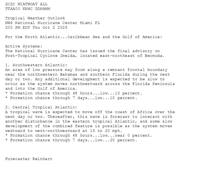
![000WTNT35 KNHC 071434TCPAT5 BULLETINTropical Storm Jerry Advisory Number 1NWS National Hurricane Center Miami FL AL1020251100 AM AST Tue Oct 07 2025 ...TROPICAL STORM JERRY FORMS OVER THE TROPICAL CENTRAL ATLANTIC......THE TENTH NAMED STORM OF THE SEASON... SUMMARY OF 1100 AM AST...1500 UTC...INFORMATION-----------------------------------------------LOCATION...11.5N 44.6WABOUT 1315 MI...2120 KM ESE OF THE NORTHERN LEEWARD ISLANDSMAXIMUM SUSTAINED WINDS...45 MPH...75 KM/HPRESENT MOVEMENT...W OR 280 DEGREES AT 24 MPH...39 KM/HMINIMUM CENTRAL PRESSURE...1006 MB...29.71 INCHES WATCHES AND WARNINGS--------------------There are no coastal watches or warnings in effect.Interests in the northern Leeward Islands should monitor theprogress of Jerry as Tropical Storm Watches could be requiredlater today or tonight. DISCUSSION AND OUTLOOK----------------------At 1100 AM AST (1500 UTC), the center of the newly formed Tropical Storm Jerry was located near latitude 11.5 North, longitude 44.6 West. Jerry is moving toward the west near 24 mph (39 km/h). A decrease in forward speed and a turn to the west-northwest is expected during the next couple of days. On the forecast track, the core of the system is expected to be near or to the north of the northern Leeward Islands late Thursday and Friday. Maximum sustained winds are near 45 mph (75 km/h) with higher gusts.Steady strengthening is forecast, and Jerry is expected to become a hurricane in a day or two. Tropical-storm-force winds extend outward up to 140 miles (220 km)from the center. The estimated minimum central pressure is 1006 mb (29.71 inches). HAZARDS AFFECTING LAND----------------------Key messages for Tropical Storm Jerry can be found in the Tropical Cyclone Discussion under AWIPS header MIATCDAT5 and WMO header WTNT45 KNHC.SURF: Swells generated by Jerry are expected to reach the Leeward Islands on Thursday. These swells are likely to cause life-threatening surf and rip current conditions. Please consultproducts from your local weather office. A depiction of rip current risk for the United States can be foundat: hurricanes.gov/graphics_at[X].shtml?ripCurrents NEXT ADVISORY-------------Next complete advisory at 500 PM AST. $$Forecaster Cangialosi](https://cdn.bsky.app/img/feed_thumbnail/plain/did:plc:jqegkz2ttsudaovvehsm5yub/bafkreic33gmnsgswk3nbar24w6njeghenrd2q3zeizsthp2w5es5xfdbsi@jpeg)

Reposted by Michael Lowry


Reposted by Michael Lowry

Reposted by Michael Lowry


Reposted by Michael Lowry


Reposted by Michael Lowry


Reposted by Michael Lowry


Reposted by Michael Lowry


Reposted by Michael Lowry

Simon Lee
@simonleewx.com
· 5d

Reposted by Michael Lowry
Reposted by Michael Lowry


Reposted by Michael Lowry

