


David Medeiros
@mapbliss.bsky.social
GIS and cartography. BW photography. Woodworking. Food, family and adventure. Map posters @ www.etsy.com/shop/MapBliss. BW IG @ www.instagram.com/the.taking.lens/
Reposted by David Medeiros

Fantastic article on Georeferencing historical maps using automated processes, including local feature matching and Delaunay consistency from Beatrice Vaienti, Isabella di Lenardo and Frédéric Kaplan doi.org/10.1080/1523... #GISchat #OpenAccess


November 24, 2025 at 4:50 PM
Fantastic article on Georeferencing historical maps using automated processes, including local feature matching and Delaunay consistency from Beatrice Vaienti, Isabella di Lenardo and Frédéric Kaplan doi.org/10.1080/1523... #GISchat #OpenAccess
Maps don’t actually lie, they do exactly as they are designed to do. Most people just don’t understand maps, or Geography for that matter! 🙃
November 14, 2025 at 7:56 PM
Maps don’t actually lie, they do exactly as they are designed to do. Most people just don’t understand maps, or Geography for that matter! 🙃
Love the gradient arrows. Under appreciated symbology IMO. Nice work!
November 6, 2025 at 3:28 PM
Love the gradient arrows. Under appreciated symbology IMO. Nice work!

Small set of older dark and moody shots for the day after Halloween. 1/2 #photography #blackandwhite


November 1, 2025 at 4:27 PM
Small set of older dark and moody shots for the day after Halloween. 1/2 #photography #blackandwhite
The president is not the one who needs a dementia test, the people who voted for him are! 🙃

So the president took a dementia test, and then they administered an MRI. Where’s the media on this?
October 28, 2025 at 9:00 PM
The president is not the one who needs a dementia test, the people who voted for him are! 🙃
Reposted by David Medeiros
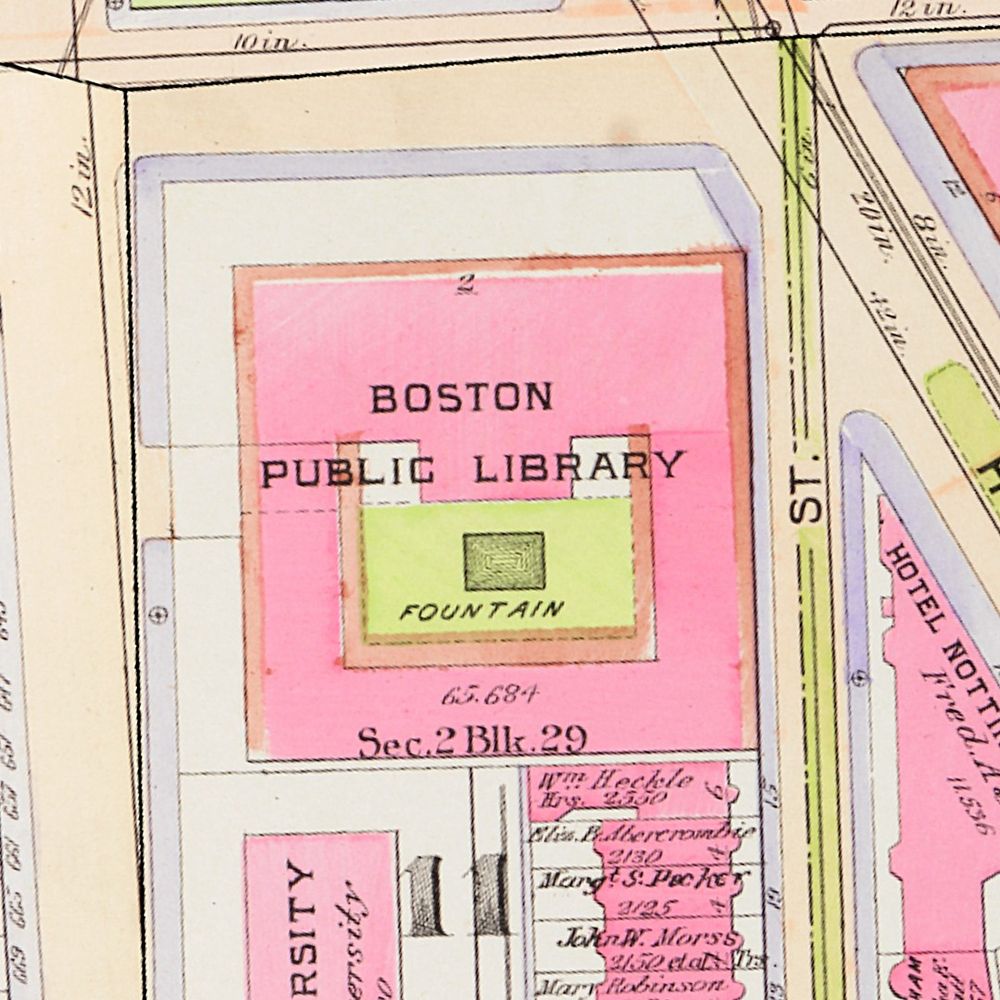
🎃Join us this Halloween (Friday, Oct 31) to take a peak at some Creepy Cartography!👻
Be warned: these maps are not for the faint of heart!
This free showing will be Friday, October 31 in the Leventhal Map & Education Center with staff members available to answer questions.
#bpl #maps #halloween
Be warned: these maps are not for the faint of heart!
This free showing will be Friday, October 31 in the Leventhal Map & Education Center with staff members available to answer questions.
#bpl #maps #halloween

October 25, 2025 at 3:34 PM
🎃Join us this Halloween (Friday, Oct 31) to take a peak at some Creepy Cartography!👻
Be warned: these maps are not for the faint of heart!
This free showing will be Friday, October 31 in the Leventhal Map & Education Center with staff members available to answer questions.
#bpl #maps #halloween
Be warned: these maps are not for the faint of heart!
This free showing will be Friday, October 31 in the Leventhal Map & Education Center with staff members available to answer questions.
#bpl #maps #halloween
Absolutely nuts that he was able to raze 1/3 of the White House so fast and without any procedure to check his actions. This is NOT his house, it's ours! #fucktrump
ABC News released before-and-after satellite images of the White House demolition.

October 23, 2025 at 9:36 PM
Absolutely nuts that he was able to raze 1/3 of the White House so fast and without any procedure to check his actions. This is NOT his house, it's ours! #fucktrump
Prince Andrew gives up royal titles due to Epstein scandal fallout. Great... now do Trump!
www.independent.co.uk/news/uk/home...
www.independent.co.uk/news/uk/home...

What has happened to Andrew’s dukedom and is he still a prince?
The King’s brother has stopped using his Duke of York title to prevent further distraction from the work of the King and the royal family.
www.independent.co.uk
October 17, 2025 at 9:04 PM
Prince Andrew gives up royal titles due to Epstein scandal fallout. Great... now do Trump!
www.independent.co.uk/news/uk/home...
www.independent.co.uk/news/uk/home...
Reposted by David Medeiros

Make your rights known at protests and beyond with our new Know Your Rights Tee, available for preorder now at aclu.org/kyrtee_


October 17, 2025 at 3:31 PM
Make your rights known at protests and beyond with our new Know Your Rights Tee, available for preorder now at aclu.org/kyrtee_
Reposted by David Medeiros

Making good maps is hard. Learn a workflow to make maps that communicate well! Join my workshop "Cartography for Professional Quality Maps in QGIS" at FOSS4G North America! @foss4gna.bsky.social #gischat
www.foss4gna.org/schedule
www.foss4gna.org/schedule

October 15, 2025 at 6:24 PM
Making good maps is hard. Learn a workflow to make maps that communicate well! Join my workshop "Cartography for Professional Quality Maps in QGIS" at FOSS4G North America! @foss4gna.bsky.social #gischat
www.foss4gna.org/schedule
www.foss4gna.org/schedule
Handy Map of SF Bay, from "The Cartoon Guide of California" by Reg Manning (1939 - David Rumsey Map Collection). #gischat
www.davidrumsey.com/luna/servlet...
www.davidrumsey.com/luna/servlet...

October 15, 2025 at 4:22 PM
Handy Map of SF Bay, from "The Cartoon Guide of California" by Reg Manning (1939 - David Rumsey Map Collection). #gischat
www.davidrumsey.com/luna/servlet...
www.davidrumsey.com/luna/servlet...


I heard the phrase "the independent nation of the State of Texas" in an academic talk today and am now trying to think of ways to insert this into all my conversations.
October 9, 2025 at 7:22 PM
I heard the phrase "the independent nation of the State of Texas" in an academic talk today and am now trying to think of ways to insert this into all my conversations.
The fascinating connection between spiders, surveying, and map making... #gischat
youtu.be/DNJM7OiqoCI?...
youtu.be/DNJM7OiqoCI?...

Why does Britain’s mapping agency have a box of spiders?
YouTube video by Chris Spargo
youtu.be
October 8, 2025 at 4:29 PM
The fascinating connection between spiders, surveying, and map making... #gischat
youtu.be/DNJM7OiqoCI?...
youtu.be/DNJM7OiqoCI?...
no kings in the USA.

October 7, 2025 at 4:32 PM
no kings in the USA.
Reposted by David Medeiros

Jane made the world a better place. RIP hero.

October 1, 2025 at 8:42 PM
Jane made the world a better place. RIP hero.

Trumps idea of "left wing groups" that incite violence so far seems to be NPR and a bunch of late night comics.
www.reuters.com/world/us/tru...
www.reuters.com/world/us/tru...

Trump says he will sign executive order to dismantle left-wing groups he claims incite violence
President Donald Trump said on Wednesday he will sign an executive order this week to dismantle "domestic terrorism networks," which he has previously alleged are funded by left-wing groups inciting violence against conservatives.
www.reuters.com
September 25, 2025 at 8:47 PM
Trumps idea of "left wing groups" that incite violence so far seems to be NPR and a bunch of late night comics.
www.reuters.com/world/us/tru...
www.reuters.com/world/us/tru...
Reposted by David Medeiros

No truer words were ever written...

September 23, 2025 at 5:53 PM
No truer words were ever written...
Recently had the chance to do a little GIS analysis for a KQED (NPR) Bay Curious podcast on the Stairways of San Francisco. Should have been a story about the triumph of GIS, ended up being more about the failure of geospatial data 🙃 But it was fun to do anyway!
www.kqed.org/news/1205633...
www.kqed.org/news/1205633...

Stairways Crisscross the Hills of San Francisco. Here's Why People Love Them | KQED
San Francisco neighborhoods are known for steep hills and stairways to help residents navigate. Whether it’s Bernal Heights, Mount Sutro, Noe Valley or Telegraph Hill, we went on an adventure to find ...
www.kqed.org
September 23, 2025 at 8:42 PM
Recently had the chance to do a little GIS analysis for a KQED (NPR) Bay Curious podcast on the Stairways of San Francisco. Should have been a story about the triumph of GIS, ended up being more about the failure of geospatial data 🙃 But it was fun to do anyway!
www.kqed.org/news/1205633...
www.kqed.org/news/1205633...
Reposted by David Medeiros

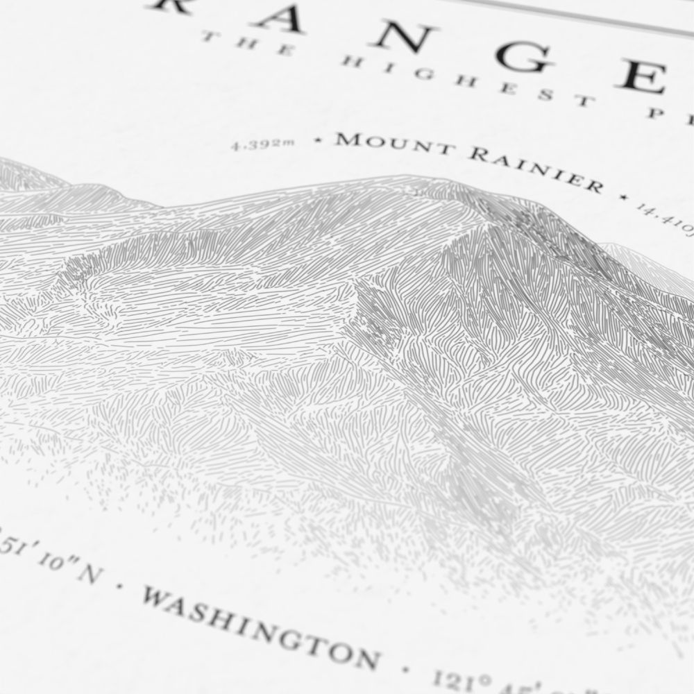
New poster! Hachure illustrations of the highest Cascade Range volcanoes. This one took a lot of experimentation to get the layout right. If you or someone you know loves this area, check it out. www.etsy.com/listing/4373...


September 23, 2025 at 7:38 PM
New poster! Hachure illustrations of the highest Cascade Range volcanoes. This one took a lot of experimentation to get the layout right. If you or someone you know loves this area, check it out. www.etsy.com/listing/4373...