


Dónal
@pearoid.bsky.social
Urban Planning, GIS and Cartography musings
www.spatialoverlay.xyz
www.spatialoverlay.xyz
Reposted by Dónal

This #map title could be "Retirement with a sea view in Belgium".
See online version on Eurostat website: tinyurl.com/2ps59n6a
See online version on Eurostat website: tinyurl.com/2ps59n6a

January 29, 2026 at 4:08 PM
This #map title could be "Retirement with a sea view in Belgium".
See online version on Eurostat website: tinyurl.com/2ps59n6a
See online version on Eurostat website: tinyurl.com/2ps59n6a
Reposted by Dónal

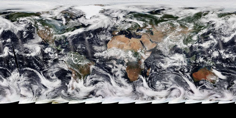
📸 The first official images from @eumetsat.int's MTG-S1 satellite are in 👀
🔗 esa.int/Applications/Observing_the_Earth/Meteorological_missions/meteosat_third_generation/Europe_s_next-generation_weather_satellite_sends_back_first_images
@thalesaleniaspace.bsky.social
🔗 esa.int/Applications/Observing_the_Earth/Meteorological_missions/meteosat_third_generation/Europe_s_next-generation_weather_satellite_sends_back_first_images
@thalesaleniaspace.bsky.social


January 27, 2026 at 10:30 AM
📸 The first official images from @eumetsat.int's MTG-S1 satellite are in 👀
🔗 esa.int/Applications/Observing_the_Earth/Meteorological_missions/meteosat_third_generation/Europe_s_next-generation_weather_satellite_sends_back_first_images
@thalesaleniaspace.bsky.social
🔗 esa.int/Applications/Observing_the_Earth/Meteorological_missions/meteosat_third_generation/Europe_s_next-generation_weather_satellite_sends_back_first_images
@thalesaleniaspace.bsky.social
Reposted by Dónal
For a brief time in 2021, the northernmost land in the world was considered to be the newly discovered island of Qeqertaq Avannarleq north of Greenland.
But it would soon be revealed that it was just an iceberg.
But it would soon be revealed that it was just an iceberg.

January 23, 2026 at 9:49 AM
For a brief time in 2021, the northernmost land in the world was considered to be the newly discovered island of Qeqertaq Avannarleq north of Greenland.
But it would soon be revealed that it was just an iceberg.
But it would soon be revealed that it was just an iceberg.
Reposted by Dónal

couple interesting maps of climate change vulnerability across Canada by Isabeaux Graham on our team
check out more here: schoolofcities.utoronto.ca/layers-of-cl...
#maps #gis #canada #climateChange
check out more here: schoolofcities.utoronto.ca/layers-of-cl...
#maps #gis #canada #climateChange


January 14, 2026 at 9:23 PM
couple interesting maps of climate change vulnerability across Canada by Isabeaux Graham on our team
check out more here: schoolofcities.utoronto.ca/layers-of-cl...
#maps #gis #canada #climateChange
check out more here: schoolofcities.utoronto.ca/layers-of-cl...
#maps #gis #canada #climateChange
That is really cool!
For the first time, #Copernicus Sentinel-2A has captured night‑time images of Earth, spotting gas flares in the Middle East, wildfires in India and even fishing boats in South Korea.
The results from these tests are being used to prepare for Sentinel‑2 Next Generation.
The results from these tests are being used to prepare for Sentinel‑2 Next Generation.


January 15, 2026 at 8:47 AM
That is really cool!
That is really cool!
For the first time, #Copernicus Sentinel-2A has captured night‑time images of Earth, spotting gas flares in the Middle East, wildfires in India and even fishing boats in South Korea.
The results from these tests are being used to prepare for Sentinel‑2 Next Generation.
The results from these tests are being used to prepare for Sentinel‑2 Next Generation.
January 15, 2026 at 8:47 AM
That is really cool!
Reposted by Dónal
More info 👇 www.esa.int/Applications...

Sentinel-2 explores night vision
After more than 10 years in orbit, the first Copernicus Sentinel-2 satellite, Sentinel-2A, is still finding new ways to contribute to Earth observation. With its younger siblings, Sentinel-2B and Sent...
www.esa.int
January 15, 2026 at 8:41 AM
More info 👇 www.esa.int/Applications...
Reposted by Dónal

I just uploaded some new stuff to Funtography: mhinfographics.github.io/funtography/18
Visit my maps blog to learn more about the story behind this new series of maps I worked on in 2025.
Visit my maps blog to learn more about the story behind this new series of maps I worked on in 2025.

The dimming of fireflies
Some maps I create for fun in a collection I call Funtography
mhinfographics.github.io
January 11, 2026 at 2:01 PM
I just uploaded some new stuff to Funtography: mhinfographics.github.io/funtography/18
Visit my maps blog to learn more about the story behind this new series of maps I worked on in 2025.
Visit my maps blog to learn more about the story behind this new series of maps I worked on in 2025.
Reposted by Dónal

Carte : L’heure vraie en France 🇫🇷
Quand il est 12 heures à Saumur, il est 12h29 à Nice et seulement 11h58 à Bordeaux. Et entre Brest et Nice c'est presque 1 heure. #ManuelGeographie de Pernet aux Éditions Hachette - 1956 #HeureVraie #LeCartographe #France #Carte
Quand il est 12 heures à Saumur, il est 12h29 à Nice et seulement 11h58 à Bordeaux. Et entre Brest et Nice c'est presque 1 heure. #ManuelGeographie de Pernet aux Éditions Hachette - 1956 #HeureVraie #LeCartographe #France #Carte

January 4, 2026 at 3:51 PM
Carte : L’heure vraie en France 🇫🇷
Quand il est 12 heures à Saumur, il est 12h29 à Nice et seulement 11h58 à Bordeaux. Et entre Brest et Nice c'est presque 1 heure. #ManuelGeographie de Pernet aux Éditions Hachette - 1956 #HeureVraie #LeCartographe #France #Carte
Quand il est 12 heures à Saumur, il est 12h29 à Nice et seulement 11h58 à Bordeaux. Et entre Brest et Nice c'est presque 1 heure. #ManuelGeographie de Pernet aux Éditions Hachette - 1956 #HeureVraie #LeCartographe #France #Carte
Reposted by Dónal

Happy New Year! 🎉 While the Data Vis Dispatch is still on holiday break, we’ve rounded up the best-of-2025 lists celebrating data journalism, visualizations, and the people behind them. See something we missed? Send it our way, and we’ll happily include it!
www.datawrapper.de/blog/data-vi...
www.datawrapper.de/blog/data-vi...


December 30, 2025 at 2:26 PM
Happy New Year! 🎉 While the Data Vis Dispatch is still on holiday break, we’ve rounded up the best-of-2025 lists celebrating data journalism, visualizations, and the people behind them. See something we missed? Send it our way, and we’ll happily include it!
www.datawrapper.de/blog/data-vi...
www.datawrapper.de/blog/data-vi...
Reposted by Dónal

🚀 The QGIS Timelapse Plugin v0.2.0 has been released! 🎉 You can now overlay vector datasets (like administrative boundaries and roads) on your satellite imagery. 🌍✨
December 28, 2025 at 3:25 PM
🚀 The QGIS Timelapse Plugin v0.2.0 has been released! 🎉 You can now overlay vector datasets (like administrative boundaries and roads) on your satellite imagery. 🌍✨
Reposted by Dónal

another robot highlight for 2025: man wearing humanoid mocap suit kicks himself in the balls
December 27, 2025 at 5:27 PM
another robot highlight for 2025: man wearing humanoid mocap suit kicks himself in the balls
Reposted by Dónal
Create a timelpase animation for any location around the globe in second. Try it out:
Plugin page: qgis.gishub.org
GitHub: github.com/opengeos/qgi...
Video tutorial: youtu.be/D_nkIL1JVU8
#QGIS #geospatial #python #EarthEngine
Plugin page: qgis.gishub.org
GitHub: github.com/opengeos/qgi...
Video tutorial: youtu.be/D_nkIL1JVU8
#QGIS #geospatial #python #EarthEngine
QGIS Plugin Repository | GeoAI Tools
qgis.gishub.org
December 27, 2025 at 6:25 PM
Create a timelpase animation for any location around the globe in second. Try it out:
Plugin page: qgis.gishub.org
GitHub: github.com/opengeos/qgi...
Video tutorial: youtu.be/D_nkIL1JVU8
#QGIS #geospatial #python #EarthEngine
Plugin page: qgis.gishub.org
GitHub: github.com/opengeos/qgi...
Video tutorial: youtu.be/D_nkIL1JVU8
#QGIS #geospatial #python #EarthEngine
Reposted by Dónal

You want to know about this site that lets you explore data collected by the HMS Challenger from 1872–1876, an expedition that laid the foundation of oceanography. 🌊
challenger-expedition.sams.ac.uk/explore
challenger-expedition.sams.ac.uk/explore

December 22, 2025 at 9:50 AM
You want to know about this site that lets you explore data collected by the HMS Challenger from 1872–1876, an expedition that laid the foundation of oceanography. 🌊
challenger-expedition.sams.ac.uk/explore
challenger-expedition.sams.ac.uk/explore
Reposted by Dónal
Galileo 14th launch successful! 🛰️
On 17 December at 05:01 GMT/06:01 CET), Galileo satellites 33-34 were launched from Europe's Spaceport in French Guiana on an Ariane 6 rocket.
🔗 esa.int/Applications/Satellite_navigation/Galileo_s_first_Ariane_6_launch_strengthens_European_resilience
On 17 December at 05:01 GMT/06:01 CET), Galileo satellites 33-34 were launched from Europe's Spaceport in French Guiana on an Ariane 6 rocket.
🔗 esa.int/Applications/Satellite_navigation/Galileo_s_first_Ariane_6_launch_strengthens_European_resilience

December 17, 2025 at 9:56 AM
Galileo 14th launch successful! 🛰️
On 17 December at 05:01 GMT/06:01 CET), Galileo satellites 33-34 were launched from Europe's Spaceport in French Guiana on an Ariane 6 rocket.
🔗 esa.int/Applications/Satellite_navigation/Galileo_s_first_Ariane_6_launch_strengthens_European_resilience
On 17 December at 05:01 GMT/06:01 CET), Galileo satellites 33-34 were launched from Europe's Spaceport in French Guiana on an Ariane 6 rocket.
🔗 esa.int/Applications/Satellite_navigation/Galileo_s_first_Ariane_6_launch_strengthens_European_resilience
Reposted by Dónal
🚀 Good morning all! It's launch day for #Ariane6 #VA266 and Galileo. Watch the launch coverage now on #ESAwebTV2. Liftoff expected at 05:01 GMT/06:01 CET.
📺 watch.esa.int/two/
📺 watch.esa.int/two/

Watch live: Galileo launch on Ariane 6
On 17 December, two Galileo satellites will be launched on an Ariane 6 rocket from Europe’s Spaceport in French Guiana in the 14th launch of operational satellites for th...
www.esa.int
December 17, 2025 at 4:38 AM
🚀 Good morning all! It's launch day for #Ariane6 #VA266 and Galileo. Watch the launch coverage now on #ESAwebTV2. Liftoff expected at 05:01 GMT/06:01 CET.
📺 watch.esa.int/two/
📺 watch.esa.int/two/
Reposted by Dónal

CASA staff Philyoung Jeong and Dr Duncan Smith have published a new working paper on accessibility to cycle routes in London, examining new cycling indicators for tracking cycle network development, gaps in the network and challenges faced by vulnerable cyclists.
discovery.ucl.ac.uk/id/eprint/10...
discovery.ucl.ac.uk/id/eprint/10...

December 15, 2025 at 1:54 PM
CASA staff Philyoung Jeong and Dr Duncan Smith have published a new working paper on accessibility to cycle routes in London, examining new cycling indicators for tracking cycle network development, gaps in the network and challenges faced by vulnerable cyclists.
discovery.ucl.ac.uk/id/eprint/10...
discovery.ucl.ac.uk/id/eprint/10...
Reposted by Dónal
I’ve created a custom QGIS plugin repository where I share the QGIS plugins I develop. This allows you to install and test the latest plugin versions early, before they are released to the official QGIS Plugin Repository.
🔗 Explore the repository: qgis.gishub.org
#QGIS #Geospatial #OpenSource
🔗 Explore the repository: qgis.gishub.org
#QGIS #Geospatial #OpenSource

December 14, 2025 at 3:59 AM
I’ve created a custom QGIS plugin repository where I share the QGIS plugins I develop. This allows you to install and test the latest plugin versions early, before they are released to the official QGIS Plugin Repository.
🔗 Explore the repository: qgis.gishub.org
#QGIS #Geospatial #OpenSource
🔗 Explore the repository: qgis.gishub.org
#QGIS #Geospatial #OpenSource
Reposted by Dónal

Poignant comment on what we lose from the demise of the letter - as sparked by the news that Denmark’s postal service will stop carrying letters from the end of the year www.ft.com/content/feca...

December 13, 2025 at 9:42 AM
Poignant comment on what we lose from the demise of the letter - as sparked by the news that Denmark’s postal service will stop carrying letters from the end of the year www.ft.com/content/feca...
Reposted by Dónal

Correlation is not causation. Well, not always.
www.economist.com/business/202...
www.economist.com/business/202...

December 11, 2025 at 12:56 AM
Correlation is not causation. Well, not always.
www.economist.com/business/202...
www.economist.com/business/202...
Reposted by Dónal

I just published a new installment of “A Gentle Introduction to GDAL” — Python & the Command Line.
#dataviz #cartography #python #gdal
medium.com/@robsimmon/a...
#dataviz #cartography #python #gdal
medium.com/@robsimmon/a...
A Gentle Introduction to GDAL Part 10: Python & the Command Line
Scripting directly on the command line with Bash or Zsh is relatively straightforward: work out a sequence of commands, then wrap them in a…
medium.com
December 3, 2025 at 6:00 PM
I just published a new installment of “A Gentle Introduction to GDAL” — Python & the Command Line.
#dataviz #cartography #python #gdal
medium.com/@robsimmon/a...
#dataviz #cartography #python #gdal
medium.com/@robsimmon/a...
Reposted by Dónal
🔴 #LiveNow: the pre-launch media briefing for the launch of two #Galileo satellites on Ariane 6 #VA266, on #ESAWebTV until 12:00 CET. (Event in English)
📺 watch.esa.int/two
@euspa.bsky.social @ec.europa.eu @cnes.fr @transport.esa.int @thalesaleniaspace.bsky.social @thalesaleniaspace.bsky.social
📺 watch.esa.int/two
@euspa.bsky.social @ec.europa.eu @cnes.fr @transport.esa.int @thalesaleniaspace.bsky.social @thalesaleniaspace.bsky.social

December 9, 2025 at 10:01 AM
🔴 #LiveNow: the pre-launch media briefing for the launch of two #Galileo satellites on Ariane 6 #VA266, on #ESAWebTV until 12:00 CET. (Event in English)
📺 watch.esa.int/two
@euspa.bsky.social @ec.europa.eu @cnes.fr @transport.esa.int @thalesaleniaspace.bsky.social @thalesaleniaspace.bsky.social
📺 watch.esa.int/two
@euspa.bsky.social @ec.europa.eu @cnes.fr @transport.esa.int @thalesaleniaspace.bsky.social @thalesaleniaspace.bsky.social
Reposted by Dónal
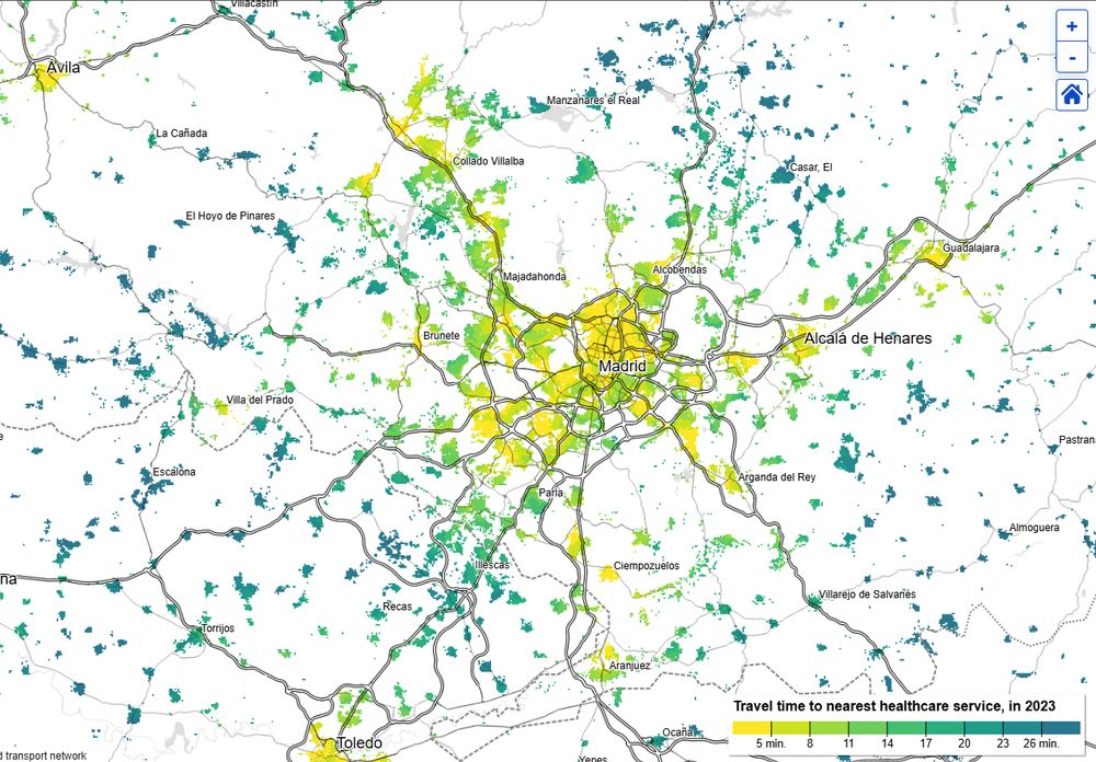
Travel times to healthcare & primary schools across the EU at 100m resolution
You can:
•View drive times to 1 or 3 nearest services.
•Compare 2023 vs 2020 to spot changes.
•Show all grid cells or only populated ones.
•Size cells by population to gauge impacted people.
ec.europa.eu/eurostat/web...
You can:
•View drive times to 1 or 3 nearest services.
•Compare 2023 vs 2020 to spot changes.
•Show all grid cells or only populated ones.
•Size cells by population to gauge impacted people.
ec.europa.eu/eurostat/web...

December 8, 2025 at 5:39 PM
Travel times to healthcare & primary schools across the EU at 100m resolution
You can:
•View drive times to 1 or 3 nearest services.
•Compare 2023 vs 2020 to spot changes.
•Show all grid cells or only populated ones.
•Size cells by population to gauge impacted people.
ec.europa.eu/eurostat/web...
You can:
•View drive times to 1 or 3 nearest services.
•Compare 2023 vs 2020 to spot changes.
•Show all grid cells or only populated ones.
•Size cells by population to gauge impacted people.
ec.europa.eu/eurostat/web...
Reposted by Dónal

The new SAM3 model from Meta is blowing my mind
Shown here: detecting putting greens, pools, and cars in Scottsdale from simple text prompts via Mapbox imagery
R, Shiny, mapgl for the UI; Python backend via @giswqs.bsky.social's segment-geospatial package (thanks Qiusheng!)
Shown here: detecting putting greens, pools, and cars in Scottsdale from simple text prompts via Mapbox imagery
R, Shiny, mapgl for the UI; Python backend via @giswqs.bsky.social's segment-geospatial package (thanks Qiusheng!)
December 8, 2025 at 7:16 PM
The new SAM3 model from Meta is blowing my mind
Shown here: detecting putting greens, pools, and cars in Scottsdale from simple text prompts via Mapbox imagery
R, Shiny, mapgl for the UI; Python backend via @giswqs.bsky.social's segment-geospatial package (thanks Qiusheng!)
Shown here: detecting putting greens, pools, and cars in Scottsdale from simple text prompts via Mapbox imagery
R, Shiny, mapgl for the UI; Python backend via @giswqs.bsky.social's segment-geospatial package (thanks Qiusheng!)
Reposted by Dónal
Discover Monochrome Hachures, a QGIS plugin that turns DEMs into stunning hachure maps! 🗺️ Inspired by @robhawkes’ tutorial, it automates slope-based line styling for beautiful terrain visualisation.
Check it out: github.com/lad-sapienza...
#QGIS #Cartography #Mapping
Check it out: github.com/lad-sapienza...
#QGIS #Cartography #Mapping


December 5, 2025 at 11:48 AM
Discover Monochrome Hachures, a QGIS plugin that turns DEMs into stunning hachure maps! 🗺️ Inspired by @robhawkes’ tutorial, it automates slope-based line styling for beautiful terrain visualisation.
Check it out: github.com/lad-sapienza...
#QGIS #Cartography #Mapping
Check it out: github.com/lad-sapienza...
#QGIS #Cartography #Mapping