


Matthew Morriss
@rockiceandsnow.bsky.social
Geomorphologist and outdoor enthusiast. Passionate educator and curious soul. Mapping Geologist @ UGS. Posts = my own. his/him pronouns. Author of: Cave records reveal recent origin of North America’s deepest canyon (PNAS)🏳️🌈🥾🧗♂️
Pinned

Cave records reveal recent origin of North America’s deepest canyon | PNAS
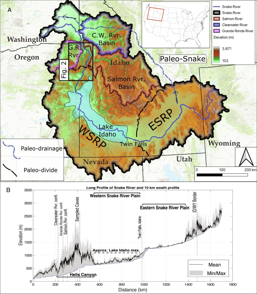
We explore how and when Hells Canyon, North America’s deepest river gorge (~2,400
m deep), formed, addressing these fundamental questions first pos...
www.pnas.org
After 15 years of thinking and work, I'm very proud to share that I finally know how old Hells Canyon - the deepest fluvial gorge in North America is - ~2.1 Ma.
For more details see our recent article in @pnas.org
www.pnas.org/doi/abs/10.1...
For more details see our recent article in @pnas.org
www.pnas.org/doi/abs/10.1...
Reposted by Matthew Morriss

My brother sent me this

August 28, 2025 at 7:38 PM
My brother sent me this
Reposted by Matthew Morriss

New seafloor mapping offshore Alaska in the Alaska-Aleutian subduction zone! #USGS #NOAA #MarineGeohazards 🧪⚒️🌊

New seafloor mapping offshore Kodiak Island, Alaska, reveals extensive submarine landslides
In summer 2025, a research team led by the USGS worked with the NOAA ship Rainier to map a large swath of seafloor offshore of Kodiak Island, Alaska, along the Alaska-Aleutian Trench.
www.usgs.gov
August 29, 2025 at 1:17 AM
New seafloor mapping offshore Alaska in the Alaska-Aleutian subduction zone! #USGS #NOAA #MarineGeohazards 🧪⚒️🌊
Reposted by Matthew Morriss

Yes, yes I do want to see this new geologic map!

You want to see this new geologic map of the contiguous US that the USGS just released.

Cooperative National Geologic Map | NGMDB
Explore the Cooperative National Geologic Map, a unified view of our Nation's geology, with interactive layers and geologic data.
ngmdb.usgs.gov
August 28, 2025 at 8:20 PM
Yes, yes I do want to see this new geologic map!
Reposted by Matthew Morriss

Can forests damp earthquake waves and thus limit co-seismic landslides? What does this mean for Critical Zone development? Postdoctoral position with Will Struble and a multi-disciplinary team (including me🌲🌲🌊🌳). Position is open until filled.
willstruble.com
#CZScience #Postdoc
willstruble.com
#CZScience #Postdoc

Will Struble
Tectonic Geomorphology and Surface Processes at the University of Houston
willstruble.com
August 20, 2025 at 11:23 PM
Can forests damp earthquake waves and thus limit co-seismic landslides? What does this mean for Critical Zone development? Postdoctoral position with Will Struble and a multi-disciplinary team (including me🌲🌲🌊🌳). Position is open until filled.
willstruble.com
#CZScience #Postdoc
willstruble.com
#CZScience #Postdoc
Does anyone know a way to project terrace location and elevations onto a river long profile, both of which were done without using Matlab/Python/R? Basically a GIS based framework?
August 20, 2025 at 10:59 PM
Does anyone know a way to project terrace location and elevations onto a river long profile, both of which were done without using Matlab/Python/R? Basically a GIS based framework?
Reposted by Matthew Morriss

The 21 July 2025 rock avalanche in the Matia'an valley in Wanrong, east Taiwan is generating a lake that could have a volume of 86 million cubic metres at the point of overtopping. This poses a threat to at least seven downstream communities.
eos.org/thelandslide...
eos.org/thelandslide...

August 8, 2025 at 6:33 AM
The 21 July 2025 rock avalanche in the Matia'an valley in Wanrong, east Taiwan is generating a lake that could have a volume of 86 million cubic metres at the point of overtopping. This poses a threat to at least seven downstream communities.
eos.org/thelandslide...
eos.org/thelandslide...
Reposted by Matthew Morriss
shamelessly made a bluesky account so I could plug my first first-author paper (!) on postfire erosion in steep rocky catchments -- go check her out!
www.science.org/doi/10.1126/...
www.science.org/doi/10.1126/...

The influence of wildfire on debris flows in a landscape of persistent disequilibrium: Columbia River Gorge, OR, USA
Debris flow erosion in rocky catchments of northern Oregon (USA) is found to be relatively insensitive to fire conditions.
www.science.org
August 11, 2025 at 1:15 AM
shamelessly made a bluesky account so I could plug my first first-author paper (!) on postfire erosion in steep rocky catchments -- go check her out!
www.science.org/doi/10.1126/...
www.science.org/doi/10.1126/...
Reposted by Matthew Morriss

NISAR has lifted off! And been successfully placed in its orbit! Good job, ISRO! Woohoo!
July 30, 2025 at 12:31 PM
NISAR has lifted off! And been successfully placed in its orbit! Good job, ISRO! Woohoo!
Reposted by Matthew Morriss

Although large earthquakes generates strong shaking over a wide area, this is somewhat mitigated by the rupture being offshore. But if the rupture breaks the ocean floor, it generates destructive a tsunami that can spread across the ocean basin in the hours that follow.

Footage of the aftermath of the earthquake in Severo-Kurilsk is published by the Kamchatka branch of the Unified Geophysical Service of the Russian Academy of Sciences
July 30, 2025 at 11:15 AM
Although large earthquakes generates strong shaking over a wide area, this is somewhat mitigated by the rupture being offshore. But if the rupture breaks the ocean floor, it generates destructive a tsunami that can spread across the ocean basin in the hours that follow.
NISAR LAUNCHED!!! congrats to all those involved!
July 30, 2025 at 12:36 PM
NISAR LAUNCHED!!! congrats to all those involved!
Reposted by Matthew Morriss
If proposal success rates are going to start looking like the probabilities of winning some money from lottery "scratchers", might as well just make grant money a lottery. Would save us all a lot of time.
June 5, 2025 at 1:31 PM
If proposal success rates are going to start looking like the probabilities of winning some money from lottery "scratchers", might as well just make grant money a lottery. Would save us all a lot of time.

Reposted by Matthew Morriss
Seeing Blatten buried again and again, from every angle...
Properly staggering! 😮😱
Properly staggering! 😮😱
May 28, 2025 at 6:51 PM
Seeing Blatten buried again and again, from every angle...
Properly staggering! 😮😱
Properly staggering! 😮😱
Reposted by Matthew Morriss

🚨New Paper🚨 @rockiceandsnow.bsky.social and others (including myself) quantify the evolution of North America's deepest canyon (sorry, Grand Canyon, it's not you).
Cave records reveal recent origin of North America’s deepest canyon | PNAS
We explore how and when Hells Canyon, North America’s deepest river gorge (~2,400
m deep), formed, addressing these fundamental questions first pos...
nam12.safelinks.protection.outlook.com
May 20, 2025 at 5:42 PM
🚨New Paper🚨 @rockiceandsnow.bsky.social and others (including myself) quantify the evolution of North America's deepest canyon (sorry, Grand Canyon, it's not you).
After 15 years of thinking and work, I'm very proud to share that I finally know how old Hells Canyon - the deepest fluvial gorge in North America is - ~2.1 Ma.
For more details see our recent article in @pnas.org
www.pnas.org/doi/abs/10.1...
For more details see our recent article in @pnas.org
www.pnas.org/doi/abs/10.1...
Cave records reveal recent origin of North America’s deepest canyon | PNAS
We explore how and when Hells Canyon, North America’s deepest river gorge (~2,400
m deep), formed, addressing these fundamental questions first pos...
www.pnas.org
May 29, 2025 at 2:07 PM
After 15 years of thinking and work, I'm very proud to share that I finally know how old Hells Canyon - the deepest fluvial gorge in North America is - ~2.1 Ma.
For more details see our recent article in @pnas.org
www.pnas.org/doi/abs/10.1...
For more details see our recent article in @pnas.org
www.pnas.org/doi/abs/10.1...
May 29, 2025 at 2:06 PM
Happy to see so much coverage of my recent research published in @pnas.org

Hells Canyon, the deepest river gorge in the United States, likely got rapidly carved 2.1 million years ago when a shifting landscape in Idaho caused a giant lake to start overflowing.

Eastern Oregon’s Hells Canyon, the deepest gorge in the US, is surprisingly young
Hells Canyon is the deepest river canyon in the United States. Now scientists have solved the mystery of when it formed.
www.opb.org
May 29, 2025 at 2:05 PM
Happy to see so much coverage of my recent research published in @pnas.org
I stand with Ukraine, and the people of Ukraine. THAT was not who we are as Americans... 🇺🇦
March 1, 2025 at 2:31 AM
I stand with Ukraine, and the people of Ukraine. THAT was not who we are as Americans... 🇺🇦
Reposted by Matthew Morriss
Proud to be a GSA member 🌎🪨⚒️🧪
Good to see this from the Geological Society of America #StandUpForScience #ScienceForAll 🧪⚒️

February 25, 2025 at 12:27 AM
Proud to be a GSA member 🌎🪨⚒️🧪

Reposted by Matthew Morriss

Reposted by Matthew Morriss
New study in PNAS: Apollo samples reveal that KREEP, the magma left after the #Moon was >99% solidified, formed 4.43 billion years ago. 🌘 This implies the Moon was born no later than ca. 140 My after the solar system’s birth. 🧪 ⚒️ @eth-eaps.bsky.social
www.pnas.org/doi/10.1073/...
www.pnas.org/doi/10.1073/...
www.pnas.org
January 6, 2025 at 9:58 PM
New study in PNAS: Apollo samples reveal that KREEP, the magma left after the #Moon was >99% solidified, formed 4.43 billion years ago. 🌘 This implies the Moon was born no later than ca. 140 My after the solar system’s birth. 🧪 ⚒️ @eth-eaps.bsky.social
www.pnas.org/doi/10.1073/...
www.pnas.org/doi/10.1073/...
Even when the structure is simple, there's something very satisfying about putting together a geologic cross-section that incorporates well data and outcrop data
#fieldgeology #UtahGeoSurvey
#fieldgeology #UtahGeoSurvey

January 2, 2025 at 11:41 PM
Even when the structure is simple, there's something very satisfying about putting together a geologic cross-section that incorporates well data and outcrop data
#fieldgeology #UtahGeoSurvey
#fieldgeology #UtahGeoSurvey
Yesterday was a not-so-subtle reminder that winter is a magical season.


December 30, 2024 at 2:05 PM
Yesterday was a not-so-subtle reminder that winter is a magical season.
Reposted by Matthew Morriss

On Monday we filed a zoning text amendment in Salt Lake City to launch our Starter Homes SLC campaign. This bold campaign aims to promote housing affordability by creating pathways for more housing options.
Learn more at the link below and join our fight for housing abundance! 🏠🏡
#yimby #slc
Learn more at the link below and join our fight for housing abundance! 🏠🏡
#yimby #slc

Action Alert: Starter Homes SLC
www.slcneighbors.org
December 20, 2024 at 8:33 PM