


Dr. Lucile Bruhat
@seismolucy.bsky.social
Earthquake physics, catastrophe modeling, disaster resilience, and risk management at AXA Group #WomenInSTEM She/her ⚒️🧪
Pinned
Dr. Lucile Bruhat
@seismolucy.bsky.social
· Dec 15
Hello to old and new comers! Thank you for following me. Here is a short intro if you don't know me: I am Lucile Bruhat or seismolucy, I work in Natural Catastrophe risk management at the AXA Group. After a PhD in Geophysics (specialized in earthquake physics) and few years in academia,
Reposted by Dr. Lucile Bruhat

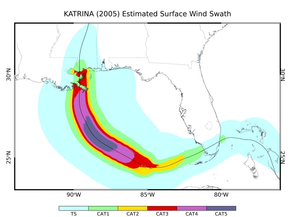
August 22, 2005... 3 days from #Katrina' s landfall in southeast FL as a Category 1 hurricane and 7 days away from its final landfall in eastern LA as a Category 3 hurricane. Here's a wind swath generated from a parametric model I coded up. Wind speed reduction over land is a generous 30%.
[1/2]
[1/2]
August 22, 2025 at 1:58 PM
August 22, 2005... 3 days from #Katrina' s landfall in southeast FL as a Category 1 hurricane and 7 days away from its final landfall in eastern LA as a Category 3 hurricane. Here's a wind swath generated from a parametric model I coded up. Wind speed reduction over land is a generous 30%.
[1/2]
[1/2]
Reposted by Dr. Lucile Bruhat
The track history with some selected satellite images are shown here.
[2/2]
[2/2]

August 22, 2025 at 1:58 PM
The track history with some selected satellite images are shown here.
[2/2]
[2/2]
Reposted by Dr. Lucile Bruhat

Much of this week's Science in Action is taken up with the Mw8.8 earthquake in Kamchatka and the tsunami that followed. www.bbc.co.uk/programmes/w...

BBC World Service - Science In Action, Getting ahead of tsunamis
The scientist behind the pacific tsunami warning and the decades of work before it.
www.bbc.co.uk
July 31, 2025 at 5:23 PM
Much of this week's Science in Action is taken up with the Mw8.8 earthquake in Kamchatka and the tsunami that followed. www.bbc.co.uk/programmes/w...
Reposted by Dr. Lucile Bruhat
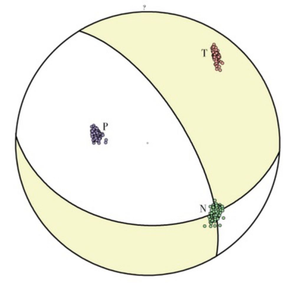
8. The Aegean slab is the oldest piece of subducting oceanic lithosphere on Earth and has just a single plain of Wadati-Benioff Zone seismicity. Models for single vs double plains of seismicity don't think about that enough--can't be a function of age/temperature.
July 30, 2025 at 10:36 PM
8. The Aegean slab is the oldest piece of subducting oceanic lithosphere on Earth and has just a single plain of Wadati-Benioff Zone seismicity. Models for single vs double plains of seismicity don't think about that enough--can't be a function of age/temperature.
Reposted by Dr. Lucile Bruhat
4. For reliable/robust features, nothing we know about the Farallon slab has really changed since Steve Grand's late 90s paper. The parts that later models agree on tend to be identical to his model.
July 30, 2025 at 10:26 PM
4. For reliable/robust features, nothing we know about the Farallon slab has really changed since Steve Grand's late 90s paper. The parts that later models agree on tend to be identical to his model.
⚒️🧪Pleased to be cited in this National Geographic article about the earthquake and tsunami risks in the northwest Pacific by @squigglyvolcano.bsky.social
#seismology #earthquakes #sciencecommunication
#seismology #earthquakes #sciencecommunication

What caused the 8.8 magnitude quake that sent tsunamis to Hawaii and California
Here's what we know about what caused the earthquake off Russia's Far East and why the tsunami it generated weren't as big as anticipated.
www.nationalgeographic.com
July 30, 2025 at 7:38 PM
⚒️🧪Pleased to be cited in this National Geographic article about the earthquake and tsunami risks in the northwest Pacific by @squigglyvolcano.bsky.social
#seismology #earthquakes #sciencecommunication
#seismology #earthquakes #sciencecommunication
Reposted by Dr. Lucile Bruhat

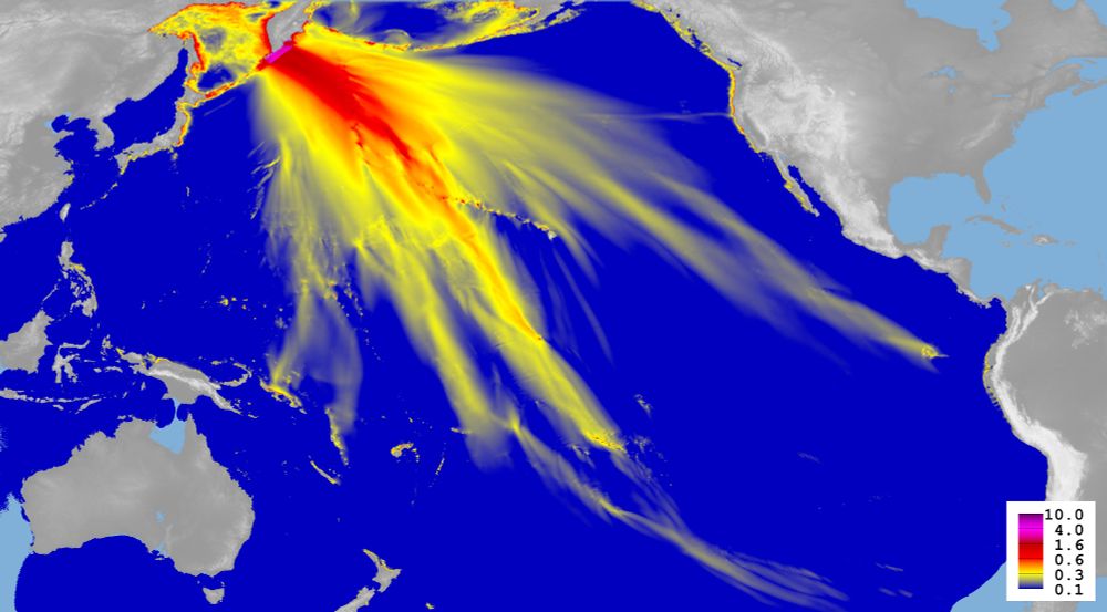
Fresh from the press, so to speak, a result of our #tsunami model based on the specifics of this earthquake (we will update it one we have more model runs). The color code is wave height in metres. The dotted line in the centre of the picture is the Hawaiian island chain.
July 30, 2025 at 3:44 PM
Fresh from the press, so to speak, a result of our #tsunami model based on the specifics of this earthquake (we will update it one we have more model runs). The color code is wave height in metres. The dotted line in the centre of the picture is the Hawaiian island chain.
Reposted by Dr. Lucile Bruhat

NEW: A magnitude 8.8 megaquake blasted tsunami waves across the Pacific today. Here's everything you need to know about it, including:
-Why it happened
-Why it generated a widespread tsunami
-Why the timing of this megaquake is a bit weird
Me, for NatGeo www.nationalgeographic.com/science/arti...
-Why it happened
-Why it generated a widespread tsunami
-Why the timing of this megaquake is a bit weird
Me, for NatGeo www.nationalgeographic.com/science/arti...
What caused the 8.8 magnitude quake that sent tsunamis to Hawaii and California
Here's what we know about what caused the earthquake off Russia's Far East and why the tsunami it generated weren't as big as anticipated.
www.nationalgeographic.com
July 30, 2025 at 3:34 PM
NEW: A magnitude 8.8 megaquake blasted tsunami waves across the Pacific today. Here's everything you need to know about it, including:
-Why it happened
-Why it generated a widespread tsunami
-Why the timing of this megaquake is a bit weird
Me, for NatGeo www.nationalgeographic.com/science/arti...
-Why it happened
-Why it generated a widespread tsunami
-Why the timing of this megaquake is a bit weird
Me, for NatGeo www.nationalgeographic.com/science/arti...
Reposted by Dr. Lucile Bruhat
NEW: You may wonder why Japan’s 2011 mag-9.1 quake created a colossal tsunami that killed 18,000 people, while today’s mag-8.8 quake made a big, but not catastrophic, tsunami.
For @sciam.bsky.social, I explore why. (Hint: it’s because the 2011 quake was SO much stronger.)
For @sciam.bsky.social, I explore why. (Hint: it’s because the 2011 quake was SO much stronger.)

Another earthquake story from @sciam.bsky.social by the always-excellent @squigglyvolcano.bsky.social explaining why the tsunami from the Russia quake wasn't as huge as the one from the 2011 Japan quake, for example. 🧪
Why the Russia Earthquake Didn't Cause a Huge Tsunami
Russia's magnitude-8.8 earthquake spawned serious tsunami warnings, but waves have been moderate so far. Here's the geological reason why
www.scientificamerican.com
July 30, 2025 at 5:19 PM
NEW: You may wonder why Japan’s 2011 mag-9.1 quake created a colossal tsunami that killed 18,000 people, while today’s mag-8.8 quake made a big, but not catastrophic, tsunami.
For @sciam.bsky.social, I explore why. (Hint: it’s because the 2011 quake was SO much stronger.)
For @sciam.bsky.social, I explore why. (Hint: it’s because the 2011 quake was SO much stronger.)
Reposted by Dr. Lucile Bruhat

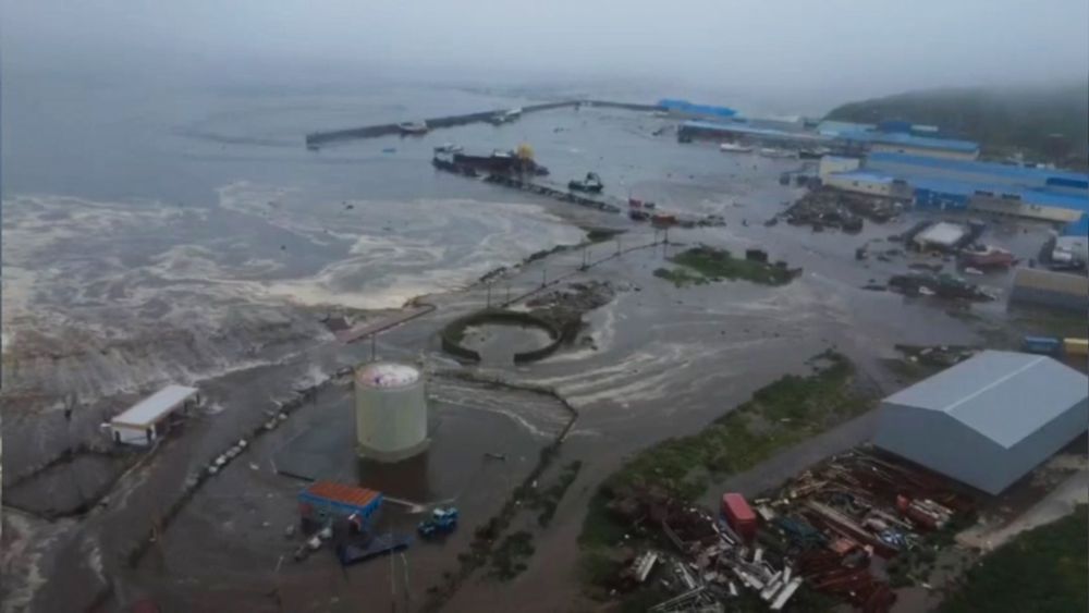
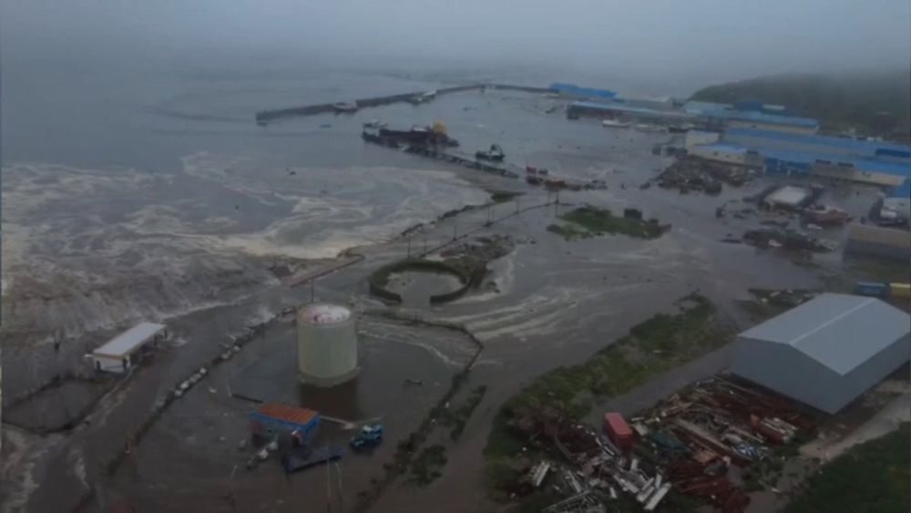
Magnitude 8.7 #earthquake in Kamchatka, following a M7.4 last week - may be largest earthquake since 2011, 8th largest on record globally, #tsunami warning in place for US west coast and Canada - the historic 1952 M9 closely caused a destructive tsunami across the Pacific
July 30, 2025 at 1:00 AM
Magnitude 8.7 #earthquake in Kamchatka, following a M7.4 last week - may be largest earthquake since 2011, 8th largest on record globally, #tsunami warning in place for US west coast and Canada - the historic 1952 M9 closely caused a destructive tsunami across the Pacific
Reposted by Dr. Lucile Bruhat

Putting on my "general geohazards communicator" hat here for a moment: In all but the *very* most extreme earthquake-generated tsunami events, locations more than ~100ft above sea level are generally safe. In vast majority of such events, "vertical evacuation" is the way to go!
July 30, 2025 at 4:09 AM
Putting on my "general geohazards communicator" hat here for a moment: In all but the *very* most extreme earthquake-generated tsunami events, locations more than ~100ft above sea level are generally safe. In vast majority of such events, "vertical evacuation" is the way to go!
Reposted by Dr. Lucile Bruhat

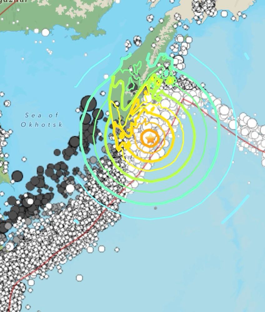
Magnitude : 5.2
Region: *Near East Coast of Kamchatka*
Time: 2025-07-30 05:51:51 UTC
Epicenter : 158.92°E 51.97°N
Depth: 30 km
*First posted at: 06:03 UTC*
https://geofon.gfz-potsdam.de/eqexplorer/events/gfz2025oudg/general
##GEOFON ##GFZ ##earthquake ##magnitude
Region: *Near East Coast of Kamchatka*
Time: 2025-07-30 05:51:51 UTC
Epicenter : 158.92°E 51.97°N
Depth: 30 km
*First posted at: 06:03 UTC*
https://geofon.gfz-potsdam.de/eqexplorer/events/gfz2025oudg/general
##GEOFON ##GFZ ##earthquake ##magnitude

July 30, 2025 at 6:10 AM
Magnitude : 5.2
Region: *Near East Coast of Kamchatka*
Time: 2025-07-30 05:51:51 UTC
Epicenter : 158.92°E 51.97°N
Depth: 30 km
*First posted at: 06:03 UTC*
https://geofon.gfz-potsdam.de/eqexplorer/events/gfz2025oudg/general
##GEOFON ##GFZ ##earthquake ##magnitude
Region: *Near East Coast of Kamchatka*
Time: 2025-07-30 05:51:51 UTC
Epicenter : 158.92°E 51.97°N
Depth: 30 km
*First posted at: 06:03 UTC*
https://geofon.gfz-potsdam.de/eqexplorer/events/gfz2025oudg/general
##GEOFON ##GFZ ##earthquake ##magnitude
Reposted by Dr. Lucile Bruhat

The M7.1 Ridgecrest earthquake struck California 6 years ago this weekend. At the time it was the largest earthquake in the area for 20 years. Events like this provide an opportunity to learn from the earth, and to share that research with the world in journals like Seismica.

July 6, 2025 at 12:18 PM
The M7.1 Ridgecrest earthquake struck California 6 years ago this weekend. At the time it was the largest earthquake in the area for 20 years. Events like this provide an opportunity to learn from the earth, and to share that research with the world in journals like Seismica.
Reposted by Dr. Lucile Bruhat

⚒️ Article: Ruptures on more structurally mature faults are more localized and therefore expected to host faster ruptures with less off-fault deformation
@quakes-from-space.bsky.social
www.nature.com/articles/s41...
@quakes-from-space.bsky.social
www.nature.com/articles/s41...

Localization of inelastic strain with fault maturity and effects on earthquake characteristics - Nature Geoscience
Ruptures on more structurally mature faults are more localized and therefore expected to host faster ruptures with less off-fault deformation, according to remote-sensing and field measurements from h...
www.nature.com
July 25, 2025 at 3:00 PM
⚒️ Article: Ruptures on more structurally mature faults are more localized and therefore expected to host faster ruptures with less off-fault deformation
@quakes-from-space.bsky.social
www.nature.com/articles/s41...
@quakes-from-space.bsky.social
www.nature.com/articles/s41...
Reposted by Dr. Lucile Bruhat
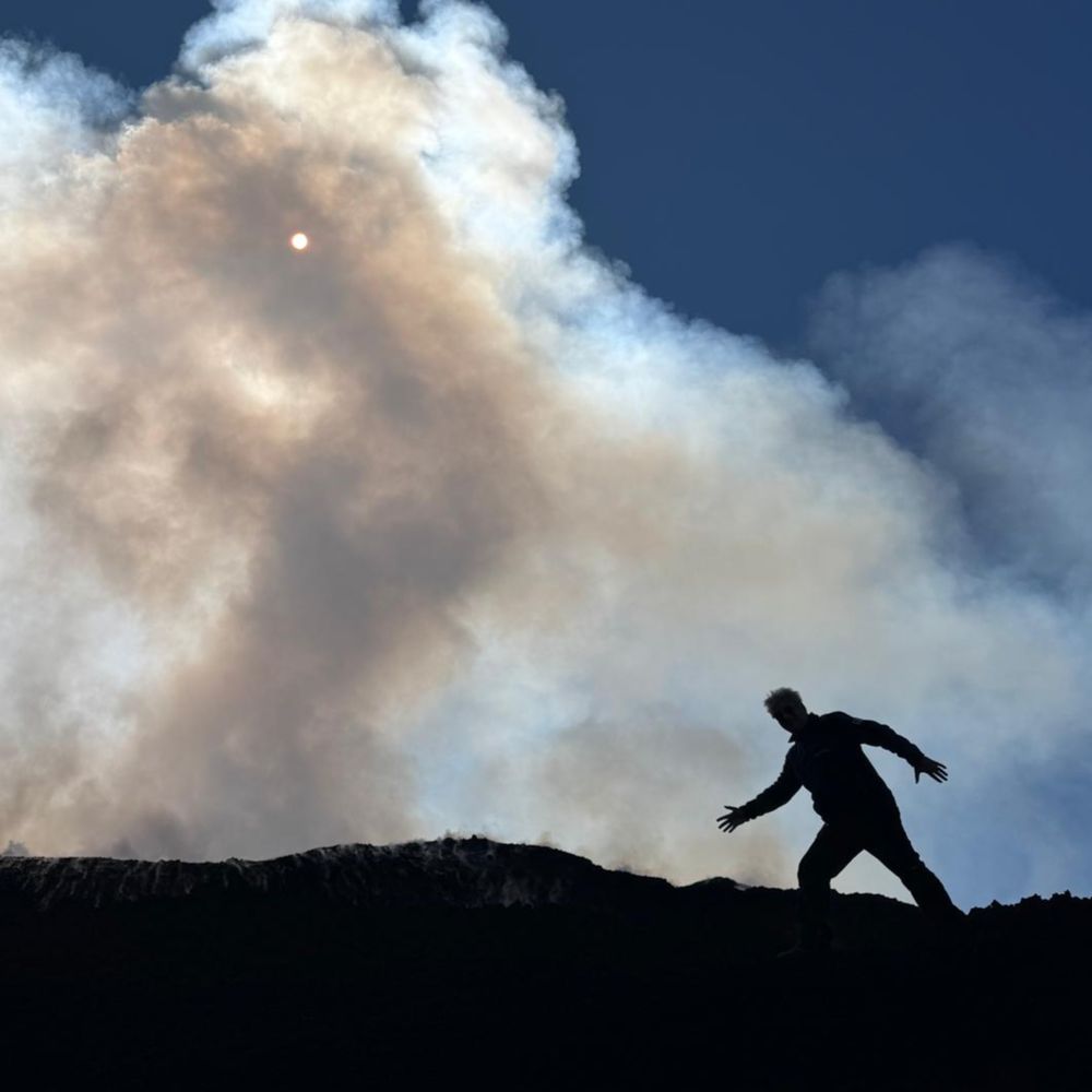
First paroxysmal eruptive episode at #Etna's Southeast Crater since 18 months, on the morning of 2 June 2025. Collapse of the northeast flank of the crater generated a spectacular (but harmless) pyroclastic flow down the upper side of the mountain. (1/2)


June 2, 2025 at 8:16 PM
First paroxysmal eruptive episode at #Etna's Southeast Crater since 18 months, on the morning of 2 June 2025. Collapse of the northeast flank of the crater generated a spectacular (but harmless) pyroclastic flow down the upper side of the mountain. (1/2)
Reposted by Dr. Lucile Bruhat
Two features that clearly demonstrate the on-fault displacement field surrounding rupture propagation are the plant next to the wall on the left and the gate itself. Since rarely do seismic stations located so close to the fault (meters away!), these features offer unprecedented observations:
🧵⚒️🧪
🧵⚒️🧪

This is mind-blowing! I have never seen footage of the slip that occurs during an earthquake! Here you see the slip that occurred during the Myanmar earthquake. 🤯
www.youtube.com/watch?v=77ub...
www.youtube.com/watch?v=77ub...
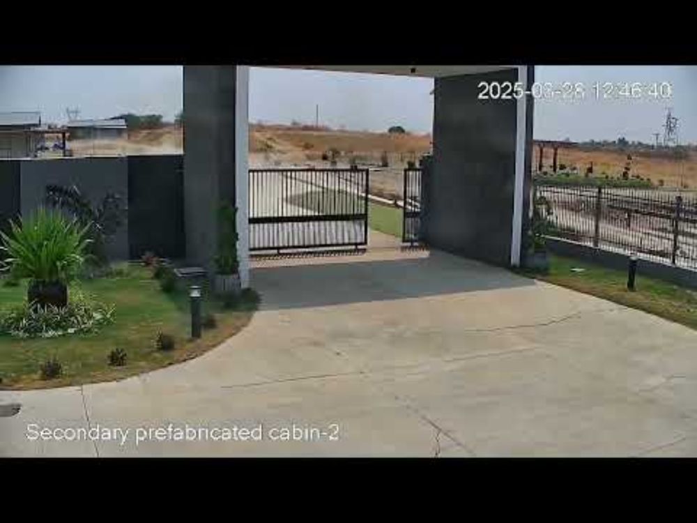
First fault rupture ever filmed. M7.9 surface rupture filmed near Thazi, Myanmar
YouTube video by 2025 Sagaing Earthquake Archive
www.youtube.com
May 12, 2025 at 6:36 PM
Two features that clearly demonstrate the on-fault displacement field surrounding rupture propagation are the plant next to the wall on the left and the gate itself. Since rarely do seismic stations located so close to the fault (meters away!), these features offer unprecedented observations:
🧵⚒️🧪
🧵⚒️🧪
Reposted by Dr. Lucile Bruhat
#FridayFold
(Probably) Cretaceous carbonates tightly folded to a recumbent fold. Honestly I have no idea of what created this fold, aside from that being is an area of left-right extension and normal faulting. Really puzzling.
On the Nuweiba-Taba road, Sinai peninsula
(Probably) Cretaceous carbonates tightly folded to a recumbent fold. Honestly I have no idea of what created this fold, aside from that being is an area of left-right extension and normal faulting. Really puzzling.
On the Nuweiba-Taba road, Sinai peninsula

April 11, 2025 at 8:11 AM
#FridayFold
(Probably) Cretaceous carbonates tightly folded to a recumbent fold. Honestly I have no idea of what created this fold, aside from that being is an area of left-right extension and normal faulting. Really puzzling.
On the Nuweiba-Taba road, Sinai peninsula
(Probably) Cretaceous carbonates tightly folded to a recumbent fold. Honestly I have no idea of what created this fold, aside from that being is an area of left-right extension and normal faulting. Really puzzling.
On the Nuweiba-Taba road, Sinai peninsula
Reposted by Dr. Lucile Bruhat
Published!!!! The first article of my PhD and the first from the lab that I set up!! 🤩🤩
We study the dynamic effects of fault bends on earthquake ruptures by imaging shear ruptures in PMMA plates propagating through bends (double bends to be exact).
www.pnas.org/doi/10.1073/...
⚒️🧪
We study the dynamic effects of fault bends on earthquake ruptures by imaging shear ruptures in PMMA plates propagating through bends (double bends to be exact).
www.pnas.org/doi/10.1073/...
⚒️🧪
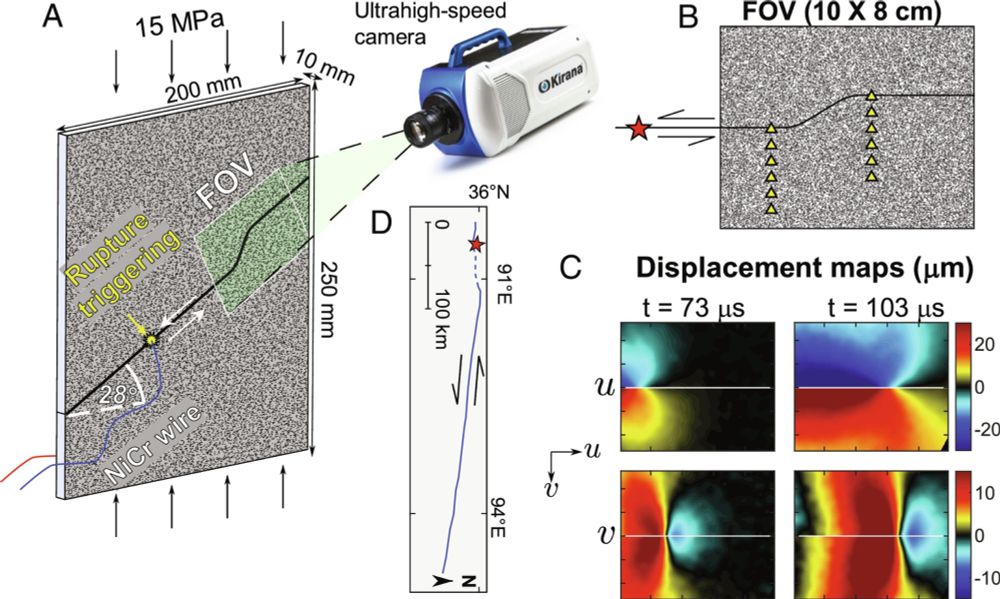
Lab earthquakes reveal a wide range of rupture behaviors controlled by fault bends | PNAS
Natural faults are typically nonplanar and exhibit multiple bends, which deviate from
the general fault orientation at different angles. However, w...
www.pnas.org
April 25, 2025 at 6:42 PM
Published!!!! The first article of my PhD and the first from the lab that I set up!! 🤩🤩
We study the dynamic effects of fault bends on earthquake ruptures by imaging shear ruptures in PMMA plates propagating through bends (double bends to be exact).
www.pnas.org/doi/10.1073/...
⚒️🧪
We study the dynamic effects of fault bends on earthquake ruptures by imaging shear ruptures in PMMA plates propagating through bends (double bends to be exact).
www.pnas.org/doi/10.1073/...
⚒️🧪
Reposted by Dr. Lucile Bruhat
For more context on today’s M6.2 #earthquake in the Sea of Marmara, a figure from Bohnhoff et al. (2013) shows the major North Anatolian Fault Zone segments with potential future rupture scenarios and their associated magnitudes. Today’s quake is located near the center of the Marmara segment. ⚒️🧪

April 23, 2025 at 11:19 AM
For more context on today’s M6.2 #earthquake in the Sea of Marmara, a figure from Bohnhoff et al. (2013) shows the major North Anatolian Fault Zone segments with potential future rupture scenarios and their associated magnitudes. Today’s quake is located near the center of the Marmara segment. ⚒️🧪
Reposted by Dr. Lucile Bruhat
This not going to end well.....

April 19, 2025 at 11:00 AM
This not going to end well.....
Reposted by Dr. Lucile Bruhat

M5.2 outside of Julian. Did you feel it? Report it!
There will be felt aftershocks. If you feel earthquake, shaking drop down to the ground, take cover underneath the sturdy object and hold on until the shaking has stopped.
earthquake.usgs.gov/earthquakes/...
There will be felt aftershocks. If you feel earthquake, shaking drop down to the ground, take cover underneath the sturdy object and hold on until the shaking has stopped.
earthquake.usgs.gov/earthquakes/...

April 14, 2025 at 5:17 PM
M5.2 outside of Julian. Did you feel it? Report it!
There will be felt aftershocks. If you feel earthquake, shaking drop down to the ground, take cover underneath the sturdy object and hold on until the shaking has stopped.
earthquake.usgs.gov/earthquakes/...
There will be felt aftershocks. If you feel earthquake, shaking drop down to the ground, take cover underneath the sturdy object and hold on until the shaking has stopped.
earthquake.usgs.gov/earthquakes/...
Reposted by Dr. Lucile Bruhat
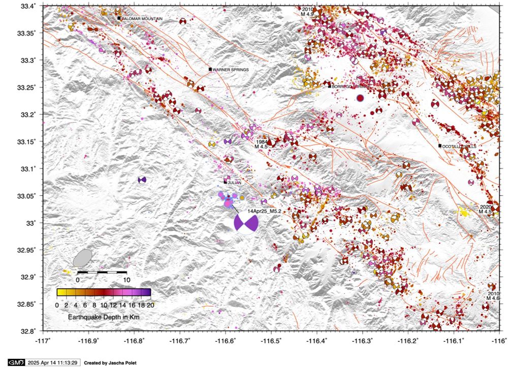
Map of today’s M5.2 #earthquake near Julian in the context of regional past seismicity. This event was located near the Elsinore fault and relatively deep at 18 km.
🧪⚒️
🧪⚒️
April 14, 2025 at 6:17 PM
Map of today’s M5.2 #earthquake near Julian in the context of regional past seismicity. This event was located near the Elsinore fault and relatively deep at 18 km.
🧪⚒️
🧪⚒️
Reposted by Dr. Lucile Bruhat

Reposted by Dr. Lucile Bruhat

Xavier Le Pichon, a pioneer in early plate tectonics research died on 22 March. Pichon developed the first global reconstruction of Earth's tectonic plates.
eos.org/articles/pod...
eos.org/articles/pod...

Podcast: Plate Tectonics, the Theory That Changed Earth Science - Eos
Third Pod from the Sun talks with pioneering geophysicist Xavier Le Pichon about what it was like to be a young scientist challenging deeply held theories.
eos.org
April 11, 2025 at 2:00 PM
Xavier Le Pichon, a pioneer in early plate tectonics research died on 22 March. Pichon developed the first global reconstruction of Earth's tectonic plates.
eos.org/articles/pod...
eos.org/articles/pod...