


Dr. Tiegan Hobbs
@thobbsgeo.bsky.social
Researching earthquakes, active faults and seismic risk 🌎🫨 at the Geological Survey of Canada 🇨🇦 | Adjunct professor at UBC and UVic | Opinions are my own
Trying, but failing, to keep a straight face while discussing the “party pickle” in a meeting.
(Pickle is a file type in #seismology, and a party is the name for a group of detected #earthquakes in the software package we’re using).
(Pickle is a file type in #seismology, and a party is the name for a group of detected #earthquakes in the software package we’re using).
November 6, 2025 at 6:31 PM
Trying, but failing, to keep a straight face while discussing the “party pickle” in a meeting.
(Pickle is a file type in #seismology, and a party is the name for a group of detected #earthquakes in the software package we’re using).
(Pickle is a file type in #seismology, and a party is the name for a group of detected #earthquakes in the software package we’re using).
Check out this new paper from my student Meg Patchett, understanding how emergency managers and first responders can use earthquake risk information in real time after a major event 🌎

When every minute counts, RED-E delivers rapid post-earthquake insights—bridging the gap between science and response in Canada.
Read now: seismica.library.mcgill.ca/article/view...
------
@seos-uvic.bsky.social
@thobbsgeo.bsky.social
@uvic.ca
Read now: seismica.library.mcgill.ca/article/view...
------
@seos-uvic.bsky.social
@thobbsgeo.bsky.social
@uvic.ca

November 6, 2025 at 1:03 AM
Check out this new paper from my student Meg Patchett, understanding how emergency managers and first responders can use earthquake risk information in real time after a major event 🌎
Reposted by Dr. Tiegan Hobbs
we just saw one of the coolest sights yet on the #pacsafe2025 research cruise!! a huge pod of Pacific white-sided dolphins 🐬 looking for food off the back of the CCGS Tully
@thobbsgeo.bsky.social @rdave6.bsky.social @charbottles.bsky.social
#fieldwork #science #womeninstem #dolphins #wildlife 🧪
@thobbsgeo.bsky.social @rdave6.bsky.social @charbottles.bsky.social
#fieldwork #science #womeninstem #dolphins #wildlife 🧪
August 21, 2025 at 5:20 PM
we just saw one of the coolest sights yet on the #pacsafe2025 research cruise!! a huge pod of Pacific white-sided dolphins 🐬 looking for food off the back of the CCGS Tully
@thobbsgeo.bsky.social @rdave6.bsky.social @charbottles.bsky.social
#fieldwork #science #womeninstem #dolphins #wildlife 🧪
@thobbsgeo.bsky.social @rdave6.bsky.social @charbottles.bsky.social
#fieldwork #science #womeninstem #dolphins #wildlife 🧪
Reposted by Dr. Tiegan Hobbs
It's national dog day, show some love and plan ahead for your furry friend (kitty too!) Have an emergency kit for your pet. zurl.co/wzREj

Pet Emergency Kit
How to prepare an emergency kit for your cat or dog. For more information visit http://www.prepareyourself.ca
www.youtube.com
August 26, 2025 at 4:00 PM
It's national dog day, show some love and plan ahead for your furry friend (kitty too!) Have an emergency kit for your pet. zurl.co/wzREj
Reposted by Dr. Tiegan Hobbs

📣 SAVE THE DATE
Mark your calendars for the SZ4D Science Community Meeting in Long Beach, CA, April 20-22, 2026, preceded by an early career event. Full program, registration, travel grant applications available in the Fall. Open to all. More info -> www.sz4d.org/events/2026-...
Mark your calendars for the SZ4D Science Community Meeting in Long Beach, CA, April 20-22, 2026, preceded by an early career event. Full program, registration, travel grant applications available in the Fall. Open to all. More info -> www.sz4d.org/events/2026-...

August 26, 2025 at 8:55 PM
📣 SAVE THE DATE
Mark your calendars for the SZ4D Science Community Meeting in Long Beach, CA, April 20-22, 2026, preceded by an early career event. Full program, registration, travel grant applications available in the Fall. Open to all. More info -> www.sz4d.org/events/2026-...
Mark your calendars for the SZ4D Science Community Meeting in Long Beach, CA, April 20-22, 2026, preceded by an early career event. Full program, registration, travel grant applications available in the Fall. Open to all. More info -> www.sz4d.org/events/2026-...
That wave was a paid actor. 🌊
But seriously, thanks to @nredick.bsky.social and our other Apply-to-Sail participants for capturing some cool moments on #PACSAFE2025!
But seriously, thanks to @nredick.bsky.social and our other Apply-to-Sail participants for capturing some cool moments on #PACSAFE2025!
sneak peek of @thobbsgeo.bsky.social’s interview for #pacsafe2025 during some 6m swells, she’s right: “…you’re not really in control of a lot of things” out here #fieldwork #scienceatsea #womeninstem
August 18, 2025 at 9:03 PM
That wave was a paid actor. 🌊
But seriously, thanks to @nredick.bsky.social and our other Apply-to-Sail participants for capturing some cool moments on #PACSAFE2025!
But seriously, thanks to @nredick.bsky.social and our other Apply-to-Sail participants for capturing some cool moments on #PACSAFE2025!
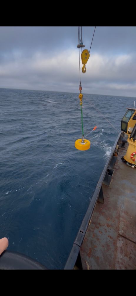
Yesterday afternoon we finished the final #Ocean Bottom #Seismometer recoveries for #PACSAFE2025, and started redeploying along the Explorer Plate! Here’s a look at our “full house”, with 23 instruments on deck.
#ScienceAtSea #Fieldwork @seos-uvic.bsky.social @eoas.ubc.ca @dalhousieu.bsky.social
#ScienceAtSea #Fieldwork @seos-uvic.bsky.social @eoas.ubc.ca @dalhousieu.bsky.social


August 18, 2025 at 2:59 PM
Yesterday afternoon we finished the final #Ocean Bottom #Seismometer recoveries for #PACSAFE2025, and started redeploying along the Explorer Plate! Here’s a look at our “full house”, with 23 instruments on deck.
#ScienceAtSea #Fieldwork @seos-uvic.bsky.social @eoas.ubc.ca @dalhousieu.bsky.social
#ScienceAtSea #Fieldwork @seos-uvic.bsky.social @eoas.ubc.ca @dalhousieu.bsky.social
Reposted by Dr. Tiegan Hobbs
PS - Earthquake hazards are inevitable in California, but we can lower our seismic risk by decreasing our exposure and vulnerability to those hazards.
August 17, 2025 at 12:45 AM
PS - Earthquake hazards are inevitable in California, but we can lower our seismic risk by decreasing our exposure and vulnerability to those hazards.
Reposted by Dr. Tiegan Hobbs

August 18, 2025 at 12:03 PM
Luckily it’s calmed down into a beautiful day today — fingers crossed to finish our last 3 recoveries for #PACSAFE2025
#ScienceAtSea #WomenInSTEM @seos-uvic.bsky.social @ubcoceans.bsky.social
#ScienceAtSea #WomenInSTEM @seos-uvic.bsky.social @ubcoceans.bsky.social

August 17, 2025 at 3:10 PM
Luckily it’s calmed down into a beautiful day today — fingers crossed to finish our last 3 recoveries for #PACSAFE2025
#ScienceAtSea #WomenInSTEM @seos-uvic.bsky.social @ubcoceans.bsky.social
#ScienceAtSea #WomenInSTEM @seos-uvic.bsky.social @ubcoceans.bsky.social
Reposted by Dr. Tiegan Hobbs
Sawyer Island located in the middle of Tracy Arm, 7 km downstream the landslide, shown here before and after the estimated 30-m high tsunami! 🌊😱
The isolated tree was particularly resilient! 🌲💪
Via @nikzimmer87.bsky.social
The isolated tree was particularly resilient! 🌲💪
Via @nikzimmer87.bsky.social


August 16, 2025 at 12:03 PM
Sawyer Island located in the middle of Tracy Arm, 7 km downstream the landslide, shown here before and after the estimated 30-m high tsunami! 🌊😱
The isolated tree was particularly resilient! 🌲💪
Via @nikzimmer87.bsky.social
The isolated tree was particularly resilient! 🌲💪
Via @nikzimmer87.bsky.social
Reposted by Dr. Tiegan Hobbs

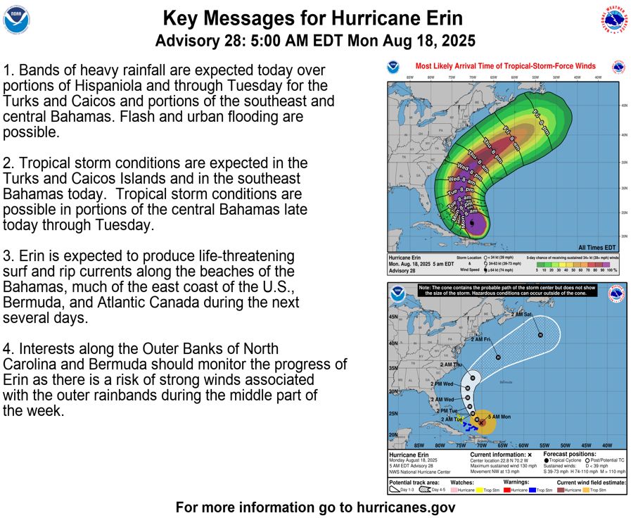
Hurricane Erin is the Atlantic's fifth Category 5 hurricane since 2022—continuing an astonishing pace of high-end storms across the ocean basin.
An inside look at Hurricane Erin’s astounding rise to Category 5 - The Weather Network
Hurricane Erin is only the 43rd Category 5 storm ever observed in the Atlantic Ocean
www.theweathernetwork.com
August 17, 2025 at 12:39 AM
Hurricane Erin is the Atlantic's fifth Category 5 hurricane since 2022—continuing an astonishing pace of high-end storms across the ocean basin.
Reposted by Dr. Tiegan Hobbs
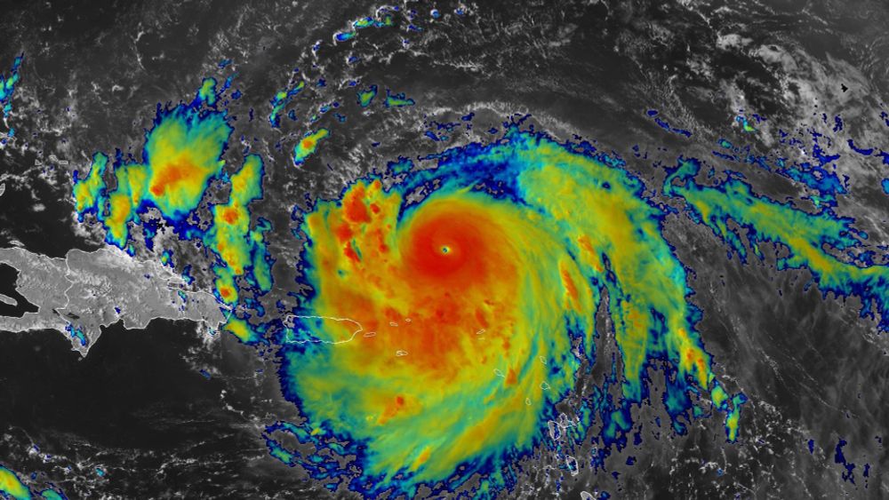
Hurricane Erin intensifies rapidly and hits CAT 5 status, bands battering Puerto Rico, dangerous ocean conditions offshore & along East Coast to come, & deployment of wave drifters in today's update for the All Hazards Consortium. Stay aware and stay safe! 🧪🌀🌊
www.youtube.com/watch?v=arwV...
www.youtube.com/watch?v=arwV...

CAT5 Hurricane Erin's Bands Battering Puerto Rico, Impacts to Bahamas, East Coast, Bermuda Likely
YouTube video by StormCenter Communications | GeoCollaborate
www.youtube.com
August 17, 2025 at 1:03 AM
Hurricane Erin intensifies rapidly and hits CAT 5 status, bands battering Puerto Rico, dangerous ocean conditions offshore & along East Coast to come, & deployment of wave drifters in today's update for the All Hazards Consortium. Stay aware and stay safe! 🧪🌀🌊
www.youtube.com/watch?v=arwV...
www.youtube.com/watch?v=arwV...
Reposted by Dr. Tiegan Hobbs

Another active fault on Vancouver Island - our new paper documents evidence for at least 3 Holocene earthquakes on the Beaufort Range fault
🌍The Beaufort Range fault is ACTIVE!
This right-lateral oblique Beaufort Range faulting occurs >100 km farther North than previously documented faults in the Cascadia forearc.
Read more: seismica.library.mcgill.ca/article/view...
NAU Research @nau-ses.bsky.social
UVic SEOS @seos-uvic.bsky.social
This right-lateral oblique Beaufort Range faulting occurs >100 km farther North than previously documented faults in the Cascadia forearc.
Read more: seismica.library.mcgill.ca/article/view...
NAU Research @nau-ses.bsky.social
UVic SEOS @seos-uvic.bsky.social

August 16, 2025 at 1:22 AM
Another active fault on Vancouver Island - our new paper documents evidence for at least 3 Holocene earthquakes on the Beaufort Range fault
The biggest #wildfire on the #OlympicPeninsula in 74 years right now. Such a gorgeous piece of preserved #wilderness under threat, but inspiring to see how hard-working folks are working to protect structures.
Surreal scenes from Olympic National Park, where buildings and bridges have been wrapped in foil to save them from the #BearGulchFire #wawx
www.kuow.org/stories/smok...
www.kuow.org/stories/smok...


August 15, 2025 at 5:26 PM
The biggest #wildfire on the #OlympicPeninsula in 74 years right now. Such a gorgeous piece of preserved #wilderness under threat, but inspiring to see how hard-working folks are working to protect structures.
Reposted by Dr. Tiegan Hobbs
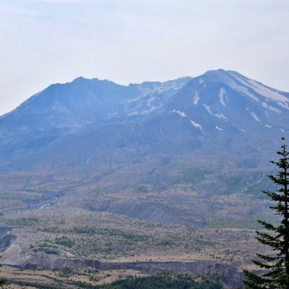
#MSH45 | Aug. 7, 1980
Eruption #5
Mount St. Helens has been quiet since July 22.
12:17 p.m.: Harmonic tremors begin.
1:30 p.m.: USGS and UW warn an eruption is likely within hours.
4:26 p.m.: The mountain obliges—pyroclastic flows down the north breach; ash column to 44K feet, drifting northeast.
Eruption #5
Mount St. Helens has been quiet since July 22.
12:17 p.m.: Harmonic tremors begin.
1:30 p.m.: USGS and UW warn an eruption is likely within hours.
4:26 p.m.: The mountain obliges—pyroclastic flows down the north breach; ash column to 44K feet, drifting northeast.
August 13, 2025 at 8:13 PM
#MSH45 | Aug. 7, 1980
Eruption #5
Mount St. Helens has been quiet since July 22.
12:17 p.m.: Harmonic tremors begin.
1:30 p.m.: USGS and UW warn an eruption is likely within hours.
4:26 p.m.: The mountain obliges—pyroclastic flows down the north breach; ash column to 44K feet, drifting northeast.
Eruption #5
Mount St. Helens has been quiet since July 22.
12:17 p.m.: Harmonic tremors begin.
1:30 p.m.: USGS and UW warn an eruption is likely within hours.
4:26 p.m.: The mountain obliges—pyroclastic flows down the north breach; ash column to 44K feet, drifting northeast.
Reposted by Dr. Tiegan Hobbs

Alaska Earthquake Center posted a nice explainer video with some of the video reconnaissance following the recent #landslide and #tsunami in Tracy Arm, south of Juneau, Alaska. It’s a whopper! 🧪⚒️

Early View of Tracy Arm Landslide Features
YouTube video by Alaska Earthquake Center
youtu.be
August 15, 2025 at 1:26 AM
Alaska Earthquake Center posted a nice explainer video with some of the video reconnaissance following the recent #landslide and #tsunami in Tracy Arm, south of Juneau, Alaska. It’s a whopper! 🧪⚒️
What a success!

We recovered all 29 ocean bottom seismographs, after 20 months on the seafloor, no losses! The ship fantail is full of seismographs. Photo shows co-chief scientist Shawn Wei and I with the flag from the last instrument,signed by the science party of the December 2023 deployment cruise.

August 15, 2025 at 2:23 PM
What a success!
Reposted by Dr. Tiegan Hobbs
Also, here is a news story about this event from Alaska Earthquake Center website earthquake.alaska.edu/major-landsl... 🪨⚒️🧪
August 12, 2025 at 11:19 PM
Also, here is a news story about this event from Alaska Earthquake Center website earthquake.alaska.edu/major-landsl... 🪨⚒️🧪
👀

AEC shared this video, courtesy of LT Chip Baucom and CDR PJ Johansen, U.S. Coast Guard.
It shows the landslide that collapsed onto South Sawyer Glacier and Tracy Arm Fjord, about 60 miles southeast of Juneau.
More information to follow
www.facebook.com/share/v/1Ccc...
earthquake.alaska.edu
🧪⚒️🌊
It shows the landslide that collapsed onto South Sawyer Glacier and Tracy Arm Fjord, about 60 miles southeast of Juneau.
More information to follow
www.facebook.com/share/v/1Ccc...
earthquake.alaska.edu
🧪⚒️🌊
August 14, 2025 at 1:03 AM
👀
Today we’re recovering #Ocean Bottom #Seismometers from near Cape St. James at the southern tip of #HaidaGwaii. They’ve been listening for a year and we hope they’ll tell us more about how the Pacific, North America and Explorer #TectonicPlates interact in this complex triple junction.
#PACSAFE2025
#PACSAFE2025

August 14, 2025 at 12:04 AM
Today we’re recovering #Ocean Bottom #Seismometers from near Cape St. James at the southern tip of #HaidaGwaii. They’ve been listening for a year and we hope they’ll tell us more about how the Pacific, North America and Explorer #TectonicPlates interact in this complex triple junction.
#PACSAFE2025
#PACSAFE2025


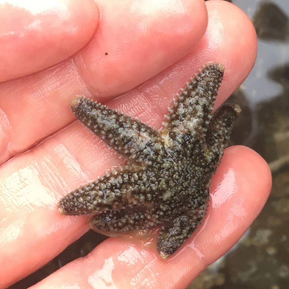
Some critters hitched a ride on our ocean bottom seismometers for #PACSAFE2025, but we don’t know what they are. Found in the north east Pacific off the coast of BC, Canada, from depths of around 2000m. Any #biologists or #marine #scientists have ideas? @whoi.edu ?
@uvic.ca @ubcoceans.bsky.social
@uvic.ca @ubcoceans.bsky.social


August 12, 2025 at 9:15 PM
Some critters hitched a ride on our ocean bottom seismometers for #PACSAFE2025, but we don’t know what they are. Found in the north east Pacific off the coast of BC, Canada, from depths of around 2000m. Any #biologists or #marine #scientists have ideas? @whoi.edu ?
@uvic.ca @ubcoceans.bsky.social
@uvic.ca @ubcoceans.bsky.social
If you’re not already, consider following one of our #PACSAFE2025 Apply-to-Sail students, Nathalie!
hanging out on the night shift of the PACSAFE 2025 OBS deployment/recovery cruise watching the sub-bottom profiler do its thing
#Pacsafe2025 #ScienceAtSea #GeoscienceOnboard #MarineGeophysics
#NRCanScience
@dalhousie.bsky.social @nrcanada.bsky.social @seos-uvic.bsky.social @uvic.ca
#Pacsafe2025 #ScienceAtSea #GeoscienceOnboard #MarineGeophysics
#NRCanScience
@dalhousie.bsky.social @nrcanada.bsky.social @seos-uvic.bsky.social @uvic.ca


August 12, 2025 at 9:07 PM
If you’re not already, consider following one of our #PACSAFE2025 Apply-to-Sail students, Nathalie!
Had a sporty day yesterday on #PACSAFE2025: an instrument released early so we had to make a 3hr detour to get it before the storm carried it off. 4m seas by the time we got to it, but the awesome deck crew of the 🇨🇦 #CoastGuard Tully pulled it off no problem.
Today we start PACSAFE recoveries!
Today we start PACSAFE recoveries!
August 11, 2025 at 10:17 PM
Had a sporty day yesterday on #PACSAFE2025: an instrument released early so we had to make a 3hr detour to get it before the storm carried it off. 4m seas by the time we got to it, but the awesome deck crew of the 🇨🇦 #CoastGuard Tully pulled it off no problem.
Today we start PACSAFE recoveries!
Today we start PACSAFE recoveries!