


Adam Clark
@adamd-clark.bsky.social
TAMU 26' | Meteorology | tamscams/tasc | Atmospheric Electricity Enthusiast | Photography |
Reposted by Adam Clark

Alrighty, ready to see something really cool? (and maybe a little nauseating)
The evolution of Hurricane Melissa's mesovortices at peak strength.
The evolution of Hurricane Melissa's mesovortices at peak strength.
October 29, 2025 at 8:10 PM
Alrighty, ready to see something really cool? (and maybe a little nauseating)
The evolution of Hurricane Melissa's mesovortices at peak strength.
The evolution of Hurricane Melissa's mesovortices at peak strength.
Reposted by Adam Clark

Given higher than usual confidence of rapid intensification (RI) from analyses of an exceptionally favorable environment & with the aid of newer hurricane models (HAFS) & Google DeepMind, NHC was able to skillfully predict Melissa's RI days in advance.

October 29, 2025 at 12:18 AM
Given higher than usual confidence of rapid intensification (RI) from analyses of an exceptionally favorable environment & with the aid of newer hurricane models (HAFS) & Google DeepMind, NHC was able to skillfully predict Melissa's RI days in advance.
Reposted by Adam Clark

Concerned for the area around Black River, Jamaica for surge flooding, apart from catastrophic wind, rainfall flood impacts.
SLOSH, wind wave model combination suggests over 6 feet of above ground inundation or higher possible in areas shaded in orange and red.
SLOSH, wind wave model combination suggests over 6 feet of above ground inundation or higher possible in areas shaded in orange and red.

October 28, 2025 at 3:33 PM
Concerned for the area around Black River, Jamaica for surge flooding, apart from catastrophic wind, rainfall flood impacts.
SLOSH, wind wave model combination suggests over 6 feet of above ground inundation or higher possible in areas shaded in orange and red.
SLOSH, wind wave model combination suggests over 6 feet of above ground inundation or higher possible in areas shaded in orange and red.
Reposted by Adam Clark

#Melissa unfortunately is still intensifying. A 9am EDT Tropical Cyclone Update indicates that winds are up to 180 mph, with an estimated minimum pressure of 896 mb.
You can see how GLM lightning has 📈 in the past hour, encircling the eye, with eye WV temp still increasing!
You can see how GLM lightning has 📈 in the past hour, encircling the eye, with eye WV temp still increasing!
October 28, 2025 at 1:13 PM
#Melissa unfortunately is still intensifying. A 9am EDT Tropical Cyclone Update indicates that winds are up to 180 mph, with an estimated minimum pressure of 896 mb.
You can see how GLM lightning has 📈 in the past hour, encircling the eye, with eye WV temp still increasing!
You can see how GLM lightning has 📈 in the past hour, encircling the eye, with eye WV temp still increasing!
Reposted by Adam Clark

In honor of Dr. Jenni Evans's legacy in tropical meteorology, I warmly welcome your participation in the upcoming session @ametsoc.org's 37th Conf. on Hurricanes & Tropical Meteorology:
"From Tropics to Extratropics: Exploring Cyclone Dynamics in Current & Future Climates in Memory of Jenni Evans"
🧵
"From Tropics to Extratropics: Exploring Cyclone Dynamics in Current & Future Climates in Memory of Jenni Evans"
🧵
October 27, 2025 at 3:59 PM
In honor of Dr. Jenni Evans's legacy in tropical meteorology, I warmly welcome your participation in the upcoming session @ametsoc.org's 37th Conf. on Hurricanes & Tropical Meteorology:
"From Tropics to Extratropics: Exploring Cyclone Dynamics in Current & Future Climates in Memory of Jenni Evans"
🧵
"From Tropics to Extratropics: Exploring Cyclone Dynamics in Current & Future Climates in Memory of Jenni Evans"
🧵
Reposted by Adam Clark

Tail Doppler Radar (TDR) data from the current recon mission into Melissa shows that the vortex is vertically stacked up to 15 km w/ the upshear/NW quad being the strongest.
This is about as favorable of a vortex structure as you’ll see for rapid intensification
Plots from @cyclonicwx.bsky.social
This is about as favorable of a vortex structure as you’ll see for rapid intensification
Plots from @cyclonicwx.bsky.social
October 26, 2025 at 12:43 AM
Tail Doppler Radar (TDR) data from the current recon mission into Melissa shows that the vortex is vertically stacked up to 15 km w/ the upshear/NW quad being the strongest.
This is about as favorable of a vortex structure as you’ll see for rapid intensification
Plots from @cyclonicwx.bsky.social
This is about as favorable of a vortex structure as you’ll see for rapid intensification
Plots from @cyclonicwx.bsky.social
Reposted by Adam Clark

It's getting tough to put into words how bad this looks for Jamaica. Here's my futile attempt this evening.

Melissa is now a rapidly intensifying hurricane, and it is plausible that it will produce an almost unimaginably bad outcome for Jamaica over the next 48 hours. Details below or at theeyewall.com.

Hurricane Melissa is rapidly intensifying southeast of Jamaica tonight
A devastating, catastrophic storm is expected in Jamaica, with torrential rain, flooding, and more for portions of Cuba, Haiti, and the Dominican Republic as well
theeyewall.substack.com
October 26, 2025 at 12:48 AM
It's getting tough to put into words how bad this looks for Jamaica. Here's my futile attempt this evening.
Reposted by Adam Clark
One thing I am watching closely tonight is the short-term motion of #Melissa.
Google DeepMind ensemble has been pretty consistent in showing a WSW motion beginning tonight, & this appears supported by the ECMWF deep-layer steering-flow as the hurricane becomes vertically deep. Diagnosed below ⤵️
Google DeepMind ensemble has been pretty consistent in showing a WSW motion beginning tonight, & this appears supported by the ECMWF deep-layer steering-flow as the hurricane becomes vertically deep. Diagnosed below ⤵️


October 25, 2025 at 11:28 PM
One thing I am watching closely tonight is the short-term motion of #Melissa.
Google DeepMind ensemble has been pretty consistent in showing a WSW motion beginning tonight, & this appears supported by the ECMWF deep-layer steering-flow as the hurricane becomes vertically deep. Diagnosed below ⤵️
Google DeepMind ensemble has been pretty consistent in showing a WSW motion beginning tonight, & this appears supported by the ECMWF deep-layer steering-flow as the hurricane becomes vertically deep. Diagnosed below ⤵️
Reposted by Adam Clark

Atlantic Tropical Storm Melissa Intermediate Advisory Number 13a
...MELISSA REORGANIZING AND POISED TO INTENSIFY SUBSTANTIALLY OVER THE NEXT FEW DAYS... ...LIFE-THREATENING AND CATASTROPHIC FLASH FLOODING AND LANDSLIDES EXPECTED IN PORTIONS OF SOUTHERN HISPANIOLA A...
Additional Details Here.
...MELISSA REORGANIZING AND POISED TO INTENSIFY SUBSTANTIALLY OVER THE NEXT FEW DAYS... ...LIFE-THREATENING AND CATASTROPHIC FLASH FLOODING AND LANDSLIDES EXPECTED IN PORTIONS OF SOUTHERN HISPANIOLA A...
Additional Details Here.


October 24, 2025 at 5:40 PM
Atlantic Tropical Storm Melissa Intermediate Advisory Number 13a
...MELISSA REORGANIZING AND POISED TO INTENSIFY SUBSTANTIALLY OVER THE NEXT FEW DAYS... ...LIFE-THREATENING AND CATASTROPHIC FLASH FLOODING AND LANDSLIDES EXPECTED IN PORTIONS OF SOUTHERN HISPANIOLA A...
Additional Details Here.
...MELISSA REORGANIZING AND POISED TO INTENSIFY SUBSTANTIALLY OVER THE NEXT FEW DAYS... ...LIFE-THREATENING AND CATASTROPHIC FLASH FLOODING AND LANDSLIDES EXPECTED IN PORTIONS OF SOUTHERN HISPANIOLA A...
Additional Details Here.
Reposted by Adam Clark
There are two noteworthy things about the latest NHC forecast for Melissa:
1. This is the first time NHC explicitly forecast rapid intensification at day 3-4 lead time
2. If latest forecast trends hold, this forecast could still be a significant intensity underestimate
1. This is the first time NHC explicitly forecast rapid intensification at day 3-4 lead time
2. If latest forecast trends hold, this forecast could still be a significant intensity underestimate

October 22, 2025 at 9:40 PM
There are two noteworthy things about the latest NHC forecast for Melissa:
1. This is the first time NHC explicitly forecast rapid intensification at day 3-4 lead time
2. If latest forecast trends hold, this forecast could still be a significant intensity underestimate
1. This is the first time NHC explicitly forecast rapid intensification at day 3-4 lead time
2. If latest forecast trends hold, this forecast could still be a significant intensity underestimate
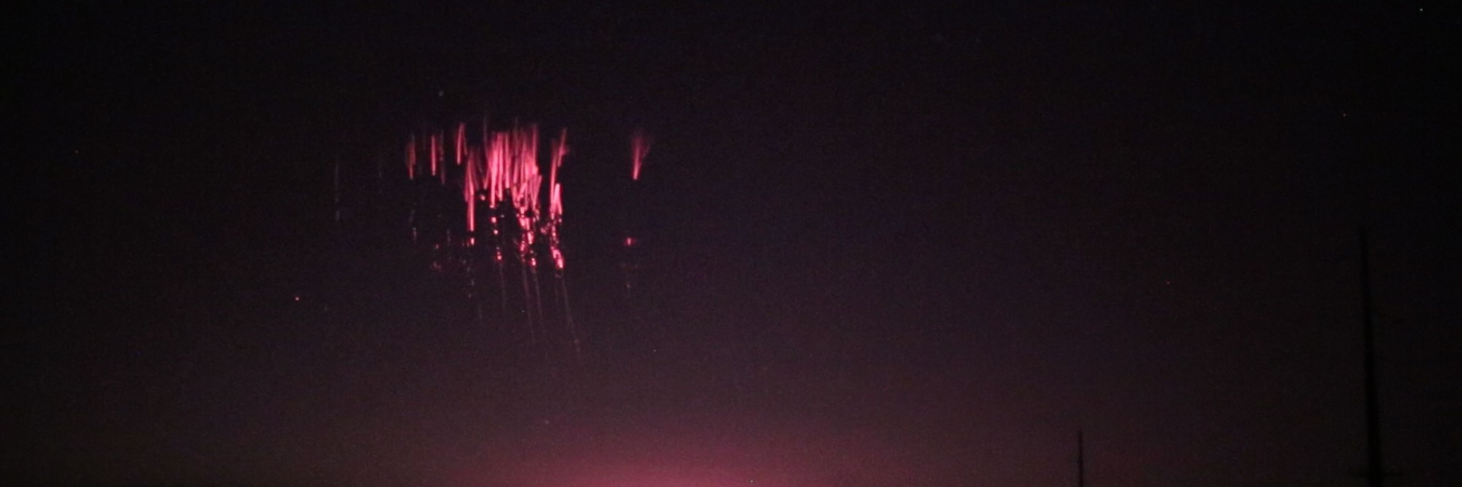
Went out for lightning a few days ago and got this nice flash. Still working on fixing my settings, but this was a huge success for me!

June 11, 2025 at 9:27 PM
Went out for lightning a few days ago and got this nice flash. Still working on fixing my settings, but this was a huge success for me!
Just spent all day writing/borrowing code to create this loop for an MCS over the gulf. I believe the yellow and red points are from miscalculations from scan point to degrees lat/lon, but I see this as a win. Took my computer 24 minutes to make this though and files weighed ~7.3 gbs. Too much imo

April 6, 2025 at 4:03 AM
Just spent all day writing/borrowing code to create this loop for an MCS over the gulf. I believe the yellow and red points are from miscalculations from scan point to degrees lat/lon, but I see this as a win. Took my computer 24 minutes to make this though and files weighed ~7.3 gbs. Too much imo
My dad sent me these pictures of big time ice accumulation on radio towers in Cedar Hill, Tx. Being downstream of a mesoscale β lake effect snow band is likely the culprit. Fascinating and uncommon imagery in north Texas.


February 20, 2025 at 4:38 PM
My dad sent me these pictures of big time ice accumulation on radio towers in Cedar Hill, Tx. Being downstream of a mesoscale β lake effect snow band is likely the culprit. Fascinating and uncommon imagery in north Texas.
Reposted by Adam Clark

Ever wanted to watch tornadogenesis in model space?
I’m excited I’ve finally been able to work on research. I’ve enjoyed my times as a GTA, but I can tell I also have a passion for this too.
HOPEFULLY this video doesn’t compress super bad
I’m excited I’ve finally been able to work on research. I’ve enjoyed my times as a GTA, but I can tell I also have a passion for this too.
HOPEFULLY this video doesn’t compress super bad
December 28, 2024 at 2:54 PM
Ever wanted to watch tornadogenesis in model space?
I’m excited I’ve finally been able to work on research. I’ve enjoyed my times as a GTA, but I can tell I also have a passion for this too.
HOPEFULLY this video doesn’t compress super bad
I’m excited I’ve finally been able to work on research. I’ve enjoyed my times as a GTA, but I can tell I also have a passion for this too.
HOPEFULLY this video doesn’t compress super bad
Had an awesome trip to Denver and learned some helpful lessons while there! Namely: Don't attempt to hike an 8000' mountain in the winter without spikes and winter clothes, especially if you're from Texas and have not gotten used to the altitude.


December 20, 2024 at 8:21 PM
Had an awesome trip to Denver and learned some helpful lessons while there! Namely: Don't attempt to hike an 8000' mountain in the winter without spikes and winter clothes, especially if you're from Texas and have not gotten used to the altitude.
The sun setting on an absolute beauty of a closed low over the Great Lakes. It's imagery like this that get me stoked for GOES-19 data to become more readily available.

November 21, 2024 at 8:38 PM
The sun setting on an absolute beauty of a closed low over the Great Lakes. It's imagery like this that get me stoked for GOES-19 data to become more readily available.
This is a shot in the dark, but does anyone know if the time from the GOES-R data from AWS is correct? Example time, image, and UCAR radar image closest in time. I'm using ABI-L2-CMIPC data as a proxy for longwave IR. If anyone has any experience with this data, your input is greatly appreciated!


November 20, 2024 at 3:42 AM
This is a shot in the dark, but does anyone know if the time from the GOES-R data from AWS is correct? Example time, image, and UCAR radar image closest in time. I'm using ABI-L2-CMIPC data as a proxy for longwave IR. If anyone has any experience with this data, your input is greatly appreciated!
Making simple mistakes coding reminds me of when I would cry while doing PEMDAS wrong in elementary school
November 19, 2024 at 9:46 PM
Making simple mistakes coding reminds me of when I would cry while doing PEMDAS wrong in elementary school
Oranges are underrated fruit
November 19, 2024 at 9:40 PM
Oranges are underrated fruit
USAGI is weakening right now (probably undergoing an EWRC), but at it's peak, it was undoubtedly a Super Typhoon. Really wish they had some sort of reconnaissance, because that pressure could be much lower than the JTWC's estimated 915 mb.

November 13, 2024 at 9:40 PM
USAGI is weakening right now (probably undergoing an EWRC), but at it's peak, it was undoubtedly a Super Typhoon. Really wish they had some sort of reconnaissance, because that pressure could be much lower than the JTWC's estimated 915 mb.
I don't think there's enough attention on this disturbance south of Hispaniola. Notable SE and SW sfc winds, as well as an mid-level center over Isla Beata, DR. While it's still likely an open wave at this point, it'll be interesting to see how fast it can organize later this week.

November 11, 2024 at 6:37 PM
I don't think there's enough attention on this disturbance south of Hispaniola. Notable SE and SW sfc winds, as well as an mid-level center over Isla Beata, DR. While it's still likely an open wave at this point, it'll be interesting to see how fast it can organize later this week.
Introductory post since I would like to part ways with twitter (X). My name is Adam Clark, currently an undergrad at Texas A&M University studying meteorology. I'm a lightning enthusiast, amateur TLE photographer, and would like to find my people on here.
November 10, 2024 at 3:09 AM
Introductory post since I would like to part ways with twitter (X). My name is Adam Clark, currently an undergrad at Texas A&M University studying meteorology. I'm a lightning enthusiast, amateur TLE photographer, and would like to find my people on here.