


Ashley San ☈
@ashleysansky.bsky.social
aspiring meteorologist | aurora and astro photographer | 19 |
My archival data website: https://www.eyewallwx.network/
🌃18 🌪️ 0
My archival data website: https://www.eyewallwx.network/
🌃18 🌪️ 0
Pinned


Hey Everyone!
I'm going to become more active on this account once more! Expect more of my photos, and TC forecasts if things of interest occur. You're definitely gonna see my face more on your timeline!
Anyway, here are some photos to get to know me by! 💜
I'm going to become more active on this account once more! Expect more of my photos, and TC forecasts if things of interest occur. You're definitely gonna see my face more on your timeline!
Anyway, here are some photos to get to know me by! 💜

February 4, 2026 at 10:31 PM

February 4, 2026 at 2:54 PM

February 3, 2026 at 7:48 PM
Re-edit time
Took me 1,5h to get this photo to a usable state
Far from perfect, but damn fine still.
14 July 2024, Poland.
Took me 1,5h to get this photo to a usable state
Far from perfect, but damn fine still.
14 July 2024, Poland.


February 3, 2026 at 1:19 PM
Re-edit time
Took me 1,5h to get this photo to a usable state
Far from perfect, but damn fine still.
14 July 2024, Poland.
Took me 1,5h to get this photo to a usable state
Far from perfect, but damn fine still.
14 July 2024, Poland.
Aurora Panoramas are pretty Neat

February 2, 2026 at 11:01 PM
Aurora Panoramas are pretty Neat
Aside from taking to the skies, I also do street photography! Here are some of my recent re-edits (and one fresh photo!)


February 1, 2026 at 10:55 PM
Aside from taking to the skies, I also do street photography! Here are some of my recent re-edits (and one fresh photo!)
Hey Everyone!
I'm going to become more active on this account once more! Expect more of my photos, and TC forecasts if things of interest occur. You're definitely gonna see my face more on your timeline!
Anyway, here are some photos to get to know me by! 💜
I'm going to become more active on this account once more! Expect more of my photos, and TC forecasts if things of interest occur. You're definitely gonna see my face more on your timeline!
Anyway, here are some photos to get to know me by! 💜
February 1, 2026 at 10:17 PM
Hey Everyone!
I'm going to become more active on this account once more! Expect more of my photos, and TC forecasts if things of interest occur. You're definitely gonna see my face more on your timeline!
Anyway, here are some photos to get to know me by! 💜
I'm going to become more active on this account once more! Expect more of my photos, and TC forecasts if things of interest occur. You're definitely gonna see my face more on your timeline!
Anyway, here are some photos to get to know me by! 💜


Warsaw, Poland photowalk in -11C


February 1, 2026 at 8:39 PM
Warsaw, Poland photowalk in -11C
Reposted by Ashley San ☈

Minden, Iowa
Pop: 598
https://en.wikipedia.org/wiki/Minden,_Iowa
Images: https://commons.wikimedia.org/w/index.php?curid=149146168
https://commons.wikimedia.org/w/index.php?curid=149146169
https://commons.wikimedia.org/w/index.php?curid=147847235
Pop: 598
https://en.wikipedia.org/wiki/Minden,_Iowa
Images: https://commons.wikimedia.org/w/index.php?curid=149146168
https://commons.wikimedia.org/w/index.php?curid=149146169
https://commons.wikimedia.org/w/index.php?curid=147847235


October 23, 2025 at 10:21 AM
Reposted by Ashley San ☈

#Melissa has struggled w/ wind shear today & the vortex remains very tilted
It's common for weak TCs like #Melissa to struggle in the Central Caribbean, an area of the Atlantic known as the Caribbean "Graveyard"
Here's a mini-🧵 on what the Caribbean "Graveyard" is & why it matters here:
It's common for weak TCs like #Melissa to struggle in the Central Caribbean, an area of the Atlantic known as the Caribbean "Graveyard"
Here's a mini-🧵 on what the Caribbean "Graveyard" is & why it matters here:
October 22, 2025 at 1:40 AM
Reposted by Ashley San ☈

This is part misleading and part false.
The false part - the West Pacific (where Halong originated from) is having a below average year so far across all metrics, especially for ACE & typhoon days.
The East Pacific is above average for number of storms/hurricanes & near average for ACE.
The false part - the West Pacific (where Halong originated from) is having a below average year so far across all metrics, especially for ACE & typhoon days.
The East Pacific is above average for number of storms/hurricanes & near average for ACE.


October 16, 2025 at 2:12 PM
This is part misleading and part false.
The false part - the West Pacific (where Halong originated from) is having a below average year so far across all metrics, especially for ACE & typhoon days.
The East Pacific is above average for number of storms/hurricanes & near average for ACE.
The false part - the West Pacific (where Halong originated from) is having a below average year so far across all metrics, especially for ACE & typhoon days.
The East Pacific is above average for number of storms/hurricanes & near average for ACE.
Reposted by Ashley San ☈

This 9-day infrared satellite animation shows the life of Hurricane #Wilma from October 15 to 24, 2005.
From a Tropical Depression on the 15th, to a Tropical Storm on the 17th, then the most intense hurricane in Atlantic history on the 19th, this was one for the history books.
#wilma20
[1/4]
From a Tropical Depression on the 15th, to a Tropical Storm on the 17th, then the most intense hurricane in Atlantic history on the 19th, this was one for the history books.
#wilma20
[1/4]
October 15, 2025 at 12:50 PM
Reposted by Ashley San ☈

Begging scientists (and media posts about science) to stop using ChatGPT-generated images
October 10, 2025 at 2:41 PM
Begging scientists (and media posts about science) to stop using ChatGPT-generated images
Reposted by Ashley San ☈
The first significant positive East Asia Mtn Torque event of the season will occur late next week into the following week.
This will yield a strong, extended Pacific Jet Stream (+EPO) in late Oct & encourage MJO/CCKW propagation across the Maritime Continent & West Pacific late Oct-early Nov.
This will yield a strong, extended Pacific Jet Stream (+EPO) in late Oct & encourage MJO/CCKW propagation across the Maritime Continent & West Pacific late Oct-early Nov.
October 9, 2025 at 2:53 PM
The first significant positive East Asia Mtn Torque event of the season will occur late next week into the following week.
This will yield a strong, extended Pacific Jet Stream (+EPO) in late Oct & encourage MJO/CCKW propagation across the Maritime Continent & West Pacific late Oct-early Nov.
This will yield a strong, extended Pacific Jet Stream (+EPO) in late Oct & encourage MJO/CCKW propagation across the Maritime Continent & West Pacific late Oct-early Nov.
Reposted by Ashley San ☈

Here's a look at #Jerry today. The system remains heavily sheared due to high shear (heightened by the movement vector), and dry air. The LLC seems to have become more elongated, posing questions about its future.
If Jerry organizes soon, it could become the 5th hurricane of the NATL season.
If Jerry organizes soon, it could become the 5th hurricane of the NATL season.
October 9, 2025 at 1:38 PM
Here's a look at #Jerry today. The system remains heavily sheared due to high shear (heightened by the movement vector), and dry air. The LLC seems to have become more elongated, posing questions about its future.
If Jerry organizes soon, it could become the 5th hurricane of the NATL season.
If Jerry organizes soon, it could become the 5th hurricane of the NATL season.
Reposted by Ashley San ☈

We are thrilled to announce that our NEW Large Language Model will be released on 11.18.25.
October 1, 2025 at 2:38 PM
We are thrilled to announce that our NEW Large Language Model will be released on 11.18.25.
Reposted by Ashley San ☈

🌀 Thursday video update on Tropical Storm #Humberto and Invest #94L (would be named #Imelda if it develops).
🌀 These two storms are raising risks to the #TurksAndCaicos, #Bahamas, southeastern US, and #Bermuda this weekend and next week, though uncertainty is high.
www.youtube.com/watch?v=lPmM...
🌀 These two storms are raising risks to the #TurksAndCaicos, #Bahamas, southeastern US, and #Bermuda this weekend and next week, though uncertainty is high.
www.youtube.com/watch?v=lPmM...

[Thursday] Humberto and a 2nd Storm Raising Risks to Bahamas, Southeast US, and Bermuda
YouTube video by Tropical Tidbits
www.youtube.com
September 25, 2025 at 8:05 PM
🌀 Thursday video update on Tropical Storm #Humberto and Invest #94L (would be named #Imelda if it develops).
🌀 These two storms are raising risks to the #TurksAndCaicos, #Bahamas, southeastern US, and #Bermuda this weekend and next week, though uncertainty is high.
www.youtube.com/watch?v=lPmM...
🌀 These two storms are raising risks to the #TurksAndCaicos, #Bahamas, southeastern US, and #Bermuda this weekend and next week, though uncertainty is high.
www.youtube.com/watch?v=lPmM...
Reposted by Ashley San ☈

Forget everything you already know about America's most notorious dead person. Jeffrey Epstein: Bad Pedophile is in select theaters October 2.
September 25, 2025 at 3:01 PM
Forget everything you already know about America's most notorious dead person. Jeffrey Epstein: Bad Pedophile is in select theaters October 2.
Incredible stuff, worth checking out!

If @ametsoc.org or @nwas.org ever gave out a "Graphic of the Year" award, it should go to Jay Cordeira, displaying the synoptics behind the Predecessor Rainfall Event before #Helene
It's an amazing graphic and displays our double whammy of 'rain and then more rain.'
It's an amazing graphic and displays our double whammy of 'rain and then more rain.'

September 24, 2025 at 6:52 PM
Incredible stuff, worth checking out!
Absolutely psychotic administration

Energy Secretary Chris Wright: "Is climate change a scam? The reaction to climate change, frankly, it has been a scam. The world has spent trillions of dollars to just make energy prices more expensive ... Trump is spot on."
September 24, 2025 at 3:16 PM
Absolutely psychotic administration
Reposted by Ashley San ☈

And I’ve stopped 7 wars. I’m very good at that. But don’t eat the pastrami. It’s very fatty. I think the UN does a very bad job. One time I threw a football 800 yards. I wasn’t even trying. The UN does a terrific job. Do you know the song Itsy Bitsy Spider? I wrote it. I’ve met Jesus. Beetlejuice!

September 23, 2025 at 11:32 PM
And I’ve stopped 7 wars. I’m very good at that. But don’t eat the pastrami. It’s very fatty. I think the UN does a very bad job. One time I threw a football 800 yards. I wasn’t even trying. The UN does a terrific job. Do you know the song Itsy Bitsy Spider? I wrote it. I’ve met Jesus. Beetlejuice!
Reposted by Ashley San ☈

Watch Gabrielle evolve from a lopsided tropical storm to a major hurricane in less than 48 hours.
Circle extends about 600 km from the storm center. Intensity values are interpolated to hourly resolution to match the infrared images, rounded to 5-kt increments in line with NHC precision.
Circle extends about 600 km from the storm center. Intensity values are interpolated to hourly resolution to match the infrared images, rounded to 5-kt increments in line with NHC precision.
September 22, 2025 at 3:32 PM
Watch Gabrielle evolve from a lopsided tropical storm to a major hurricane in less than 48 hours.
Circle extends about 600 km from the storm center. Intensity values are interpolated to hourly resolution to match the infrared images, rounded to 5-kt increments in line with NHC precision.
Circle extends about 600 km from the storm center. Intensity values are interpolated to hourly resolution to match the infrared images, rounded to 5-kt increments in line with NHC precision.
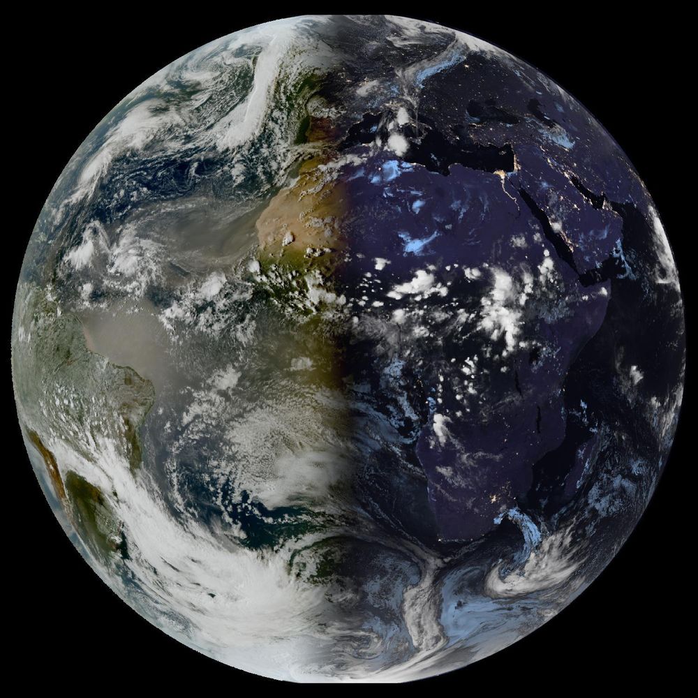
Happy equinox!
September 22, 2025 at 6:01 PM
Happy equinox!
Reposted by Ashley San ☈
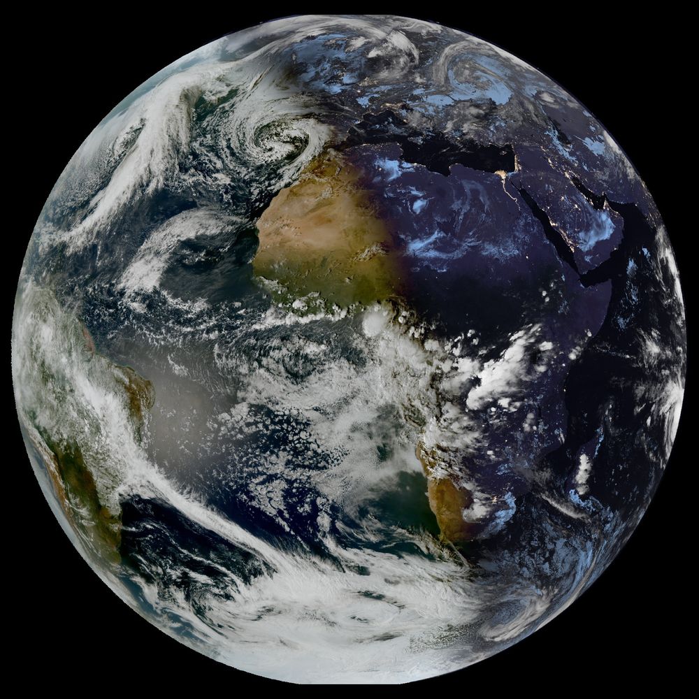
🌍 at 22/09/2025 - 17:30 (UTC)
Source: #EUMETSAT
Source: #EUMETSAT
September 22, 2025 at 6:00 PM
🌍 at 22/09/2025 - 17:30 (UTC)
Source: #EUMETSAT
Source: #EUMETSAT