


Trans Canada Bike Route Network
@bikeacrosscanada.bsky.social
Proposed Trans Canada Bicycle Route Network made through sharing of GPS tracks & end-of day locations
https://bikeacrosscanada.github.io/index.html
https://bikeacrosscanada.github.io/index.html
Happy Solstice to Everyone on Planet Earth from the Trans Canada Bike Route Network!
This is the latest KMZ file for @comaps.app , with the coloured placemarkers. You can find all the links on the website. bikeacrosscanada.github.io
Happy Solstice Everyone!
This is the latest KMZ file for @comaps.app , with the coloured placemarkers. You can find all the links on the website. bikeacrosscanada.github.io
Happy Solstice Everyone!


December 21, 2025 at 3:57 PM
Happy Solstice to Everyone on Planet Earth from the Trans Canada Bike Route Network!
This is the latest KMZ file for @comaps.app , with the coloured placemarkers. You can find all the links on the website. bikeacrosscanada.github.io
Happy Solstice Everyone!
This is the latest KMZ file for @comaps.app , with the coloured placemarkers. You can find all the links on the website. bikeacrosscanada.github.io
Happy Solstice Everyone!
Reposted by Trans Canada Bike Route Network

We're proud to reveal the logo for CoMaps — designed and chosen by the community.
From maps to code to design, CoMaps is 100% community-powered.
The Winning logo was created by @Flummic. 21 logos submitted, 6 finalists, and people collaborating.
Thank you to everyone who shaped this milestone.
From maps to code to design, CoMaps is 100% community-powered.
The Winning logo was created by @Flummic. 21 logos submitted, 6 finalists, and people collaborating.
Thank you to everyone who shaped this milestone.

July 14, 2025 at 5:46 AM
We're proud to reveal the logo for CoMaps — designed and chosen by the community.
From maps to code to design, CoMaps is 100% community-powered.
The Winning logo was created by @Flummic. 21 logos submitted, 6 finalists, and people collaborating.
Thank you to everyone who shaped this milestone.
From maps to code to design, CoMaps is 100% community-powered.
The Winning logo was created by @Flummic. 21 logos submitted, 6 finalists, and people collaborating.
Thank you to everyone who shaped this milestone.
Most Canadians live close to the Trans Canada Bike Route Network.
You can see the map and download links on the website.
bikeacrosscanada.github.io/index.html
You can see the map and download links on the website.
bikeacrosscanada.github.io/index.html

July 10, 2025 at 4:07 PM
Most Canadians live close to the Trans Canada Bike Route Network.
You can see the map and download links on the website.
bikeacrosscanada.github.io/index.html
You can see the map and download links on the website.
bikeacrosscanada.github.io/index.html
Reposted by Trans Canada Bike Route Network
We're thrilled to announce the release of CoMaps to Google Play Store, Apple App Store, and F-Droid!
· Offline Search and Route
· Saves battery
· Privacy-respecting
· Free and No Ads
What makes CoMaps special?
- Open & Transparent
- Community Empowerment
- Free & Not-for-Profit
Download Today
· Offline Search and Route
· Saves battery
· Privacy-respecting
· Free and No Ads
What makes CoMaps special?
- Open & Transparent
- Community Empowerment
- Free & Not-for-Profit
Download Today

July 3, 2025 at 7:39 AM
We're thrilled to announce the release of CoMaps to Google Play Store, Apple App Store, and F-Droid!
· Offline Search and Route
· Saves battery
· Privacy-respecting
· Free and No Ads
What makes CoMaps special?
- Open & Transparent
- Community Empowerment
- Free & Not-for-Profit
Download Today
· Offline Search and Route
· Saves battery
· Privacy-respecting
· Free and No Ads
What makes CoMaps special?
- Open & Transparent
- Community Empowerment
- Free & Not-for-Profit
Download Today
After downloading the app, you can download the Trans Canada Bike Route Network KMZ file, and zoom and pan across the network to download all of the map areas you'll need for your trip across the country.
bikeacrosscanada.github.io
bikeacrosscanada.github.io
July 3, 2025 at 9:34 AM
After downloading the app, you can download the Trans Canada Bike Route Network KMZ file, and zoom and pan across the network to download all of the map areas you'll need for your trip across the country.
bikeacrosscanada.github.io
bikeacrosscanada.github.io
Reposted by Trans Canada Bike Route Network
Logo Voting Round 1 is Complete!
The logos with the most votes:
1. “CO-Arrow”
2. “CoMaps Arrow”
3. “Windy-Road-Pin"
4. "Co Compass"
5. "Clouds/continents arrow"
6. "CM-Compass-Split"
Next Step
These logos will be iterated and improved. See codeberg.org/comaps/Gover...
The logos with the most votes:
1. “CO-Arrow”
2. “CoMaps Arrow”
3. “Windy-Road-Pin"
4. "Co Compass"
5. "Clouds/continents arrow"
6. "CM-Compass-Split"
Next Step
These logos will be iterated and improved. See codeberg.org/comaps/Gover...

June 13, 2025 at 4:44 AM
Logo Voting Round 1 is Complete!
The logos with the most votes:
1. “CO-Arrow”
2. “CoMaps Arrow”
3. “Windy-Road-Pin"
4. "Co Compass"
5. "Clouds/continents arrow"
6. "CM-Compass-Split"
Next Step
These logos will be iterated and improved. See codeberg.org/comaps/Gover...
The logos with the most votes:
1. “CO-Arrow”
2. “CoMaps Arrow”
3. “Windy-Road-Pin"
4. "Co Compass"
5. "Clouds/continents arrow"
6. "CM-Compass-Split"
Next Step
These logos will be iterated and improved. See codeberg.org/comaps/Gover...
Reposted by Trans Canada Bike Route Network

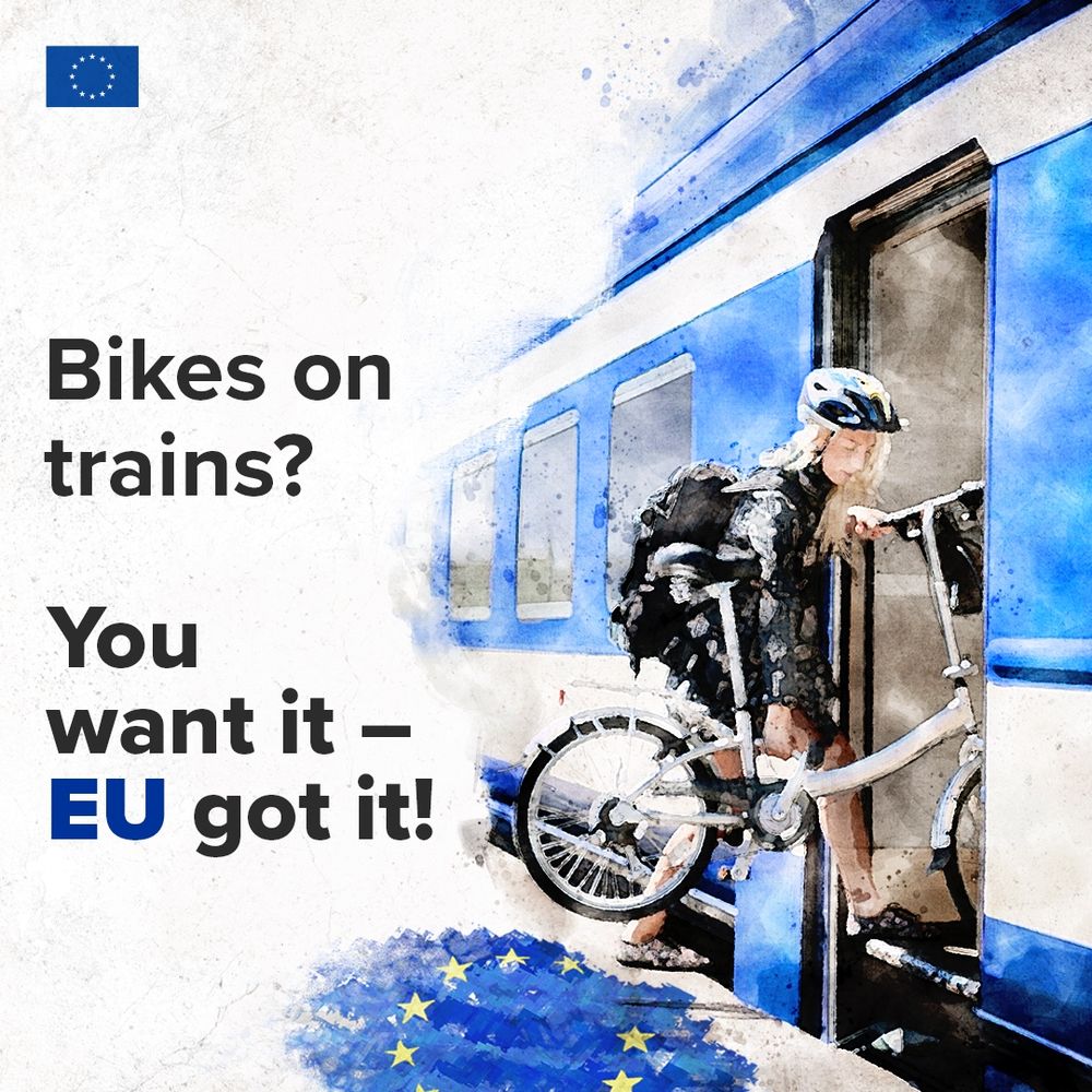
Hop on, ride off! 🚆🚲
As of today, bikes are welcome on-board of EU trains. All new and upgraded trains in the EU will have dedicated spots for full-sized bicycles.
So, you can ride wherever the train takes you!
As of today, bikes are welcome on-board of EU trains. All new and upgraded trains in the EU will have dedicated spots for full-sized bicycles.
So, you can ride wherever the train takes you!
June 7, 2025 at 8:12 AM
Hop on, ride off! 🚆🚲
As of today, bikes are welcome on-board of EU trains. All new and upgraded trains in the EU will have dedicated spots for full-sized bicycles.
So, you can ride wherever the train takes you!
As of today, bikes are welcome on-board of EU trains. All new and upgraded trains in the EU will have dedicated spots for full-sized bicycles.
So, you can ride wherever the train takes you!
The Trans Canada Trail is schizophrenic. It doesn't know what it is, and changes user type at random places.
@transcanadatrail.bsky.social
@transcanadatrail.bsky.social
June 5, 2025 at 7:10 AM
The Trans Canada Trail is schizophrenic. It doesn't know what it is, and changes user type at random places.
@transcanadatrail.bsky.social
@transcanadatrail.bsky.social
Reposted by Trans Canada Bike Route Network

1.33 million journeys daily and growing 📈

May 30, 2025 at 6:00 AM
1.33 million journeys daily and growing 📈
The Trans Canada Trail is NOT a hiking trail. It's a SCAM.
It gets in the way of building a National Cycling Route Network!
It gets in the way of building a National Cycling Route Network!

May 30, 2025 at 2:31 AM
The Trans Canada Trail is NOT a hiking trail. It's a SCAM.
It gets in the way of building a National Cycling Route Network!
It gets in the way of building a National Cycling Route Network!
What do you think of the Trans Canada Bike Route Network?
I've built (designed) the Trans Canada Bike Route Network, the proposed National Cycling Route Network for Canada and am looking for feedback from the global cycling community to make it better.
bikeacrosscanada.github.io/index.html
I've built (designed) the Trans Canada Bike Route Network, the proposed National Cycling Route Network for Canada and am looking for feedback from the global cycling community to make it better.
bikeacrosscanada.github.io/index.html
Bike Across Canada
Bike Across Canada Route Network information
bikeacrosscanada.github.io
May 21, 2025 at 5:31 PM
What do you think of the Trans Canada Bike Route Network?
I've built (designed) the Trans Canada Bike Route Network, the proposed National Cycling Route Network for Canada and am looking for feedback from the global cycling community to make it better.
bikeacrosscanada.github.io/index.html
I've built (designed) the Trans Canada Bike Route Network, the proposed National Cycling Route Network for Canada and am looking for feedback from the global cycling community to make it better.
bikeacrosscanada.github.io/index.html
Reposted by Trans Canada Bike Route Network

“A review of scientific research has found that pedestrians and cyclists are 44% more likely to be killed in a collision with an SUV or light truck, compared to a passenger car.
The outlook is even more dire for children, who are 82% more likely to be killed when struck by the larger vehicles.”
The outlook is even more dire for children, who are 82% more likely to be killed when struck by the larger vehicles.”

Research shows SUVs and utes are the most deadly vehicles
SUVs and large utes are among the most popular vehicles for car buyers in Australia. They may also be the most deadly.
www.thenewdaily.com.au
May 18, 2025 at 1:57 AM
“A review of scientific research has found that pedestrians and cyclists are 44% more likely to be killed in a collision with an SUV or light truck, compared to a passenger car.
The outlook is even more dire for children, who are 82% more likely to be killed when struck by the larger vehicles.”
The outlook is even more dire for children, who are 82% more likely to be killed when struck by the larger vehicles.”
Reposted by Trans Canada Bike Route Network

Ontario Premier Ford’s New Plan Will Result in Cyclists Dying, But Does He Care?
momentummag.com/ontario-prem...
momentummag.com/ontario-prem...

Ontario Premier Ford's New Plan Will Result in Cyclists Dying, But Does He Care?
The moves Ontario Premier Doug Ford wants to make could be the most misguided and dangerously ignorant in recent memory.
momentummag.com
May 15, 2025 at 1:23 PM
Ontario Premier Ford’s New Plan Will Result in Cyclists Dying, But Does He Care?
momentummag.com/ontario-prem...
momentummag.com/ontario-prem...
Reposted by Trans Canada Bike Route Network

Berlin's Critical Mass rides are superb. I participated in this Mother's Day ride a few years ago, awe-inspiring and...routine.

5.000 personnes à vélo sur une autoroute à Berlin
😍😍😍
Si toutes ces personnes étaient en voiture, cela ferait un embouteillage de 9km.
A vélo c'est 100% fluide
😎😎😎
(🎬 11/05/25 #DrumAndBass on The Bike #Berlin #DomWhiting)
😍😍😍
Si toutes ces personnes étaient en voiture, cela ferait un embouteillage de 9km.
A vélo c'est 100% fluide
😎😎😎
(🎬 11/05/25 #DrumAndBass on The Bike #Berlin #DomWhiting)
May 15, 2025 at 1:10 PM
Berlin's Critical Mass rides are superb. I participated in this Mother's Day ride a few years ago, awe-inspiring and...routine.
@jagmeetsingh.ca
Will an NDP Government support building a National Cycling Route Network???
bikeacrosscanada.github.io/index.html
The Trans Canada Bike Route Network is the framework for a National Cycling Route Network of Canada.
Will an NDP Government support building a National Cycling Route Network???
bikeacrosscanada.github.io/index.html
The Trans Canada Bike Route Network is the framework for a National Cycling Route Network of Canada.
Bike Across Canada
Bike Across Canada Route Network information
bikeacrosscanada.github.io
April 23, 2025 at 4:45 PM
@jagmeetsingh.ca
Will an NDP Government support building a National Cycling Route Network???
bikeacrosscanada.github.io/index.html
The Trans Canada Bike Route Network is the framework for a National Cycling Route Network of Canada.
Will an NDP Government support building a National Cycling Route Network???
bikeacrosscanada.github.io/index.html
The Trans Canada Bike Route Network is the framework for a National Cycling Route Network of Canada.
Wonderful to see @organicmaps.bsky.social offline maps showing more details for the Outdoors map!


March 16, 2025 at 3:11 AM
Wonderful to see @organicmaps.bsky.social offline maps showing more details for the Outdoors map!
Reposted by Trans Canada Bike Route Network


Here's 2 segments along Route Verte 1 from Levis to Montmagny Quebec with separated cycling lanes.
The rest between are on roads.
www.google.com/maps/d/u/0/v...
[C1 C2 and C3] Levis QC Parcours Des Anses Route Verte 1 6.7km
[C1 C2 and C3] Montmagny QC Boulevard Taché o Route Verte 1 289m
The rest between are on roads.
www.google.com/maps/d/u/0/v...
[C1 C2 and C3] Levis QC Parcours Des Anses Route Verte 1 6.7km
[C1 C2 and C3] Montmagny QC Boulevard Taché o Route Verte 1 289m


January 24, 2025 at 5:29 PM
Here's 2 segments along Route Verte 1 from Levis to Montmagny Quebec with separated cycling lanes.
The rest between are on roads.
www.google.com/maps/d/u/0/v...
[C1 C2 and C3] Levis QC Parcours Des Anses Route Verte 1 6.7km
[C1 C2 and C3] Montmagny QC Boulevard Taché o Route Verte 1 289m
The rest between are on roads.
www.google.com/maps/d/u/0/v...
[C1 C2 and C3] Levis QC Parcours Des Anses Route Verte 1 6.7km
[C1 C2 and C3] Montmagny QC Boulevard Taché o Route Verte 1 289m
This is the first part of the Trans Canada Bike Route Network.

January 20, 2025 at 4:52 PM
This is the first part of the Trans Canada Bike Route Network.
A big THANK YOU to Andrzej Popowski who made the free Garmin MapSource/BaseCamp Canada OSM reputable Topo map
(This is something I wanted since 2008)
www.gmaptool.eu/en/content/c...
If you have the capacity to donate, Euros are accepted via PayPal
(This is something I wanted since 2008)
www.gmaptool.eu/en/content/c...
If you have the capacity to donate, Euros are accepted via PayPal
Canada OSM Topo | GMapTool
Detailed map of Canada based on OpenStreetMap data. Version 43, compilation December 2024.
www.gmaptool.eu
January 11, 2025 at 6:31 PM
A big THANK YOU to Andrzej Popowski who made the free Garmin MapSource/BaseCamp Canada OSM reputable Topo map
(This is something I wanted since 2008)
www.gmaptool.eu/en/content/c...
If you have the capacity to donate, Euros are accepted via PayPal
(This is something I wanted since 2008)
www.gmaptool.eu/en/content/c...
If you have the capacity to donate, Euros are accepted via PayPal
Reposted by Trans Canada Bike Route Network

Thanks @tombabin.bsky.social for making this clip about how pervasive car brain and motonormativity is as a barrier to encouraging more walking, cycling, and transit. Draws some parallels to smoking back in the 1950's. #BikeTO #WalkTO #TTC #TOpoli #VisionZero www.youtube.com/watch?v=PdqZ...

This is the biggest barrier to more people riding bikes in cities
YouTube video by Shifter
www.youtube.com
January 11, 2025 at 3:06 PM
Thanks @tombabin.bsky.social for making this clip about how pervasive car brain and motonormativity is as a barrier to encouraging more walking, cycling, and transit. Draws some parallels to smoking back in the 1950's. #BikeTO #WalkTO #TTC #TOpoli #VisionZero www.youtube.com/watch?v=PdqZ...
Reposted by Trans Canada Bike Route Network

The GDB (Garmin Database) file, GPX (mapping wizardry) file and KMZ (mapping magic) files have now been updated.
Enjoy responsibly.
Instructions on the website.
bikeacrosscanada.github.io
Enjoy responsibly.
Instructions on the website.
bikeacrosscanada.github.io
Bike Across Canada
Bike Across Canada Route Network information
bikeacrosscanada.github.io
January 2, 2025 at 5:19 PM
The GDB (Garmin Database) file, GPX (mapping wizardry) file and KMZ (mapping magic) files have now been updated.
Enjoy responsibly.
Instructions on the website.
bikeacrosscanada.github.io
Enjoy responsibly.
Instructions on the website.
bikeacrosscanada.github.io
[C1 and C3] Gatineau QC Sentier Des Voyageurs Pathway 1.2km
Screenshot from webmap from NCC (National Capital Commission) Cycling Map - Ottawa-Gatineau
ncc-ccn.maps.arcgis.com/apps/View/in...
PDF map
ncc-website-2.s3.amazonaws.com/documents/NC...
Screenshot from webmap from NCC (National Capital Commission) Cycling Map - Ottawa-Gatineau
ncc-ccn.maps.arcgis.com/apps/View/in...
PDF map
ncc-website-2.s3.amazonaws.com/documents/NC...

December 29, 2024 at 7:33 PM
[C1 and C3] Gatineau QC Sentier Des Voyageurs Pathway 1.2km
Screenshot from webmap from NCC (National Capital Commission) Cycling Map - Ottawa-Gatineau
ncc-ccn.maps.arcgis.com/apps/View/in...
PDF map
ncc-website-2.s3.amazonaws.com/documents/NC...
Screenshot from webmap from NCC (National Capital Commission) Cycling Map - Ottawa-Gatineau
ncc-ccn.maps.arcgis.com/apps/View/in...
PDF map
ncc-website-2.s3.amazonaws.com/documents/NC...