Dave Petley
@davepetley.bsky.social
2.4K followers 330 following 510 posts
Vice-Chancellor at the University of Hull in England. Landslides, hazards, risk, vulnerability and resilience, plus a bit of Coventry City. #pusb #Breturn
Posts Media Videos Starter Packs
davepetley.bsky.social
The 17 December 2024 Takhini River landslide and river-ice tsunami in Whitehorse, Yukon, Canada highlights the role of progressive failure in frozen materials.
eos.org/thelandslide...
Surface elevation change detection comparing 2013 lidar DTM to a 2025 DSM created from UAV photos for the Takhini River landslide.
Reposted by Dave Petley
watershedlab.bsky.social
New satellite imagery from @planet.com this morning shows water overflowing the Tala Hydroelectric Power Station in Bhutan. Hard to tell from this, but appears the dam hasn't failed at this point. Unclear what the brown stuff is in the lake upstream. Logs or sediment upstream landslides perhaps? 🧪⚒️
davepetley.bsky.social
In July 2025 I recorded 71 fatal landslides worldwide, with the loss of 214 lives. The number of fatal landslides was above the long term mean of 58.1 landslides.
eos.org/thelandslide...
The number of fatal landslides to 29 July 2025, displayed in pentads. For comparison, the long term mean (2004 to 2016) and the exceptional year of 2024 are also shown. The number of fatal landslides to the end of July 2025 by month.
davepetley.bsky.social
Some excellent before and after imagery is now available showing the evolution of the Matai'an landslide dam. This image has been posted to Facebook by Tony Lee. More details on my blog:-
eos.org/thelandslide...
Before and after images of the Matai'an landslide dam. Video by Tony Lee, posted to Facebook.
davepetley.bsky.social
Good digital data is now being published by ASRS that presents the scale of landscape change that occurred as a result of the Matai'an landslide hazard cascade. There is also interesting information about the root causes of the vulnerability of the town of Guangfu.
eos.org/thelandslide...
Vertical elevation change before and after the Matai'an landslide and dam breach. Published by ASRS in Taiwan.
davepetley.bsky.social
Today is the first meeting of the Research Plus collective, a panel discussion on the role of universities in growth and the industrial strategy.
The panel of the Research Plus meeting.
Reposted by Dave Petley
mabrideau.bsky.social
Over the last three years, @drewbrayshaw.bsky.social, @geocron.bsky.social, me, and twelve colleagues have been compiling a Preliminary Canadian Landslide Database. Version 12 is now available and contains 25,500 entries.
zenodo.org/records/1721...
Overview map of Canada with location points of 25,550 landslides symbolized according to 30 landslide types. Background image is a combination of ESRI satellite imagery and hillshade of the NRCan High Resolution Digital Elevation Model (HRDEM) Overview map of Canada with location points of 25,550 landslides symbolized according to what version of the database they were last modified. It shows that more than half they entries were added or modified in the latest version. Background image is a combination of ESRI satellite imagery and hillshade of the NRCan High Resolution Digital Elevation Model (HRDEM)
davepetley.bsky.social
Satellite images from @planet.com show the level of damage in Guangfu in the aftermath of the breach of the Matai'an landslide dam in Taiwan in typhoon #Ragasa. It is clear that a very large part of the community suffered inundation. In total, 18 people were killed and seven are still missing.
A satellite image of Guangfu township in Taiwan before the breach of the Matai'an landslide dam. Image copyright Planet, used with permission. Image dated 30 August 2025. A satellite image of Guangfu township in Taiwan after the breach of the Matai'an landslide dam. Image copyright Planet, used with permission. Image dated 27 September 2025.
davepetley.bsky.social
At least 15 people are known to have been killed by the debris flow and flood from the landslide dam breach that was triggered by typhoon Ragasa. Reports suggest that 15.4 million tonnes of water were released, causing 80 metres of downcutting of the landslide dam.
eos.org/thelandslide...
The aftermath of the landslide dam breach at Matai'an in Taiwan.  Image by the Forest Protection Department.
Reposted by Dave Petley
kristencook.bsky.social
The Matai’an landslide dam in eastern Taiwan has failed this afternoon (eos.org/thelandslide...), flooding Guangfu, about 15 km downstream focustaiwan.tw/society/2025.... Even in the middle of a typhoon, the resulting flood produced a detectable seismic signal at stations ~40 km away.
Seismic waveforms and power spectral density plots showing the signal of a landslide lake outburst flood. Planet satellite image from August 2025 of a large landslide blocking a river and creating a lake.
davepetley.bsky.social
The Matai'an landslide dam breach in Taiwan during super typhoon Ragasa is now known to have killed 14 people. Some reports indicate a substantial number may still be missing (one source suggests 124 people). Understandably, the situation is quite unclear at the moment.
#supertyphoonRagasa #Ragasa
davepetley.bsky.social
Yes, they provide two versions (Panel 1 and Panel 2). Same data, different scales. CWA recommends Panel 2 when precipitation >400 mm.
The availability of two panels was, I believe, a recommendation after Typhoon Morakot.
davepetley.bsky.social
Overtopping and downcutting, probably, although it is not entirely clear.
davepetley.bsky.social
The breach was triggered by extreme rainfall. This is the Central Weather Administration map of rainfall to 10 pm local time. Some stations have recorded >600 mm of rainfall. The average *annual* rainfall in Hull, where I work, (which is hardly a desert) is 693 mm.
www.cwa.gov.tw/V8/E/P/Rainf...
CWA rainfall map for Taiwan for 23 September 2025. A large area f eastern Taiwan has received over 300 mm.
davepetley.bsky.social
The Matai'an landslide dam in Taiwan has breached today in response to extreme rainfall from super typhoon Ragasa. There is a superlative storyboard (in Mandarin) that contains details, including images and video:-
storymaps.arcgis.com/stories/5864...
馬太鞍溪堰塞湖監測紀實
應變時間軸暨避難疏散準備作為
storymaps.arcgis.com
Reposted by Dave Petley
crwilson84.bsky.social
I have no words, never knew these photos existed!!! @davepetley.bsky.social have you seen them?
mountsthelens1980.bsky.social
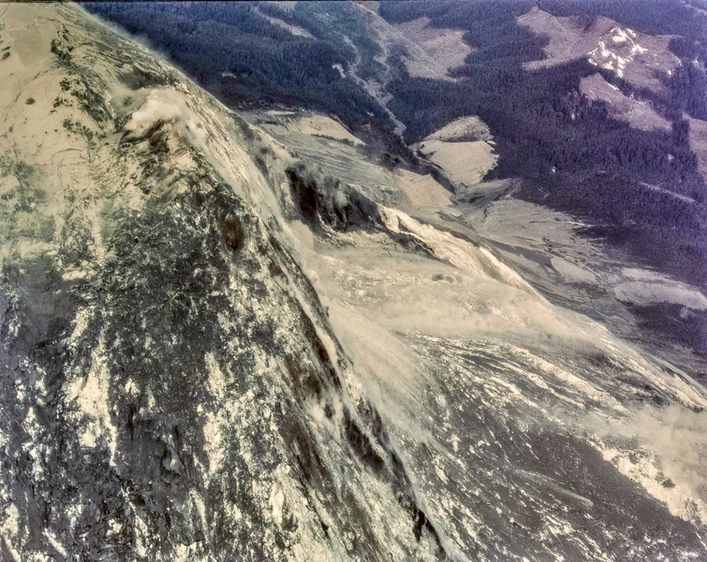
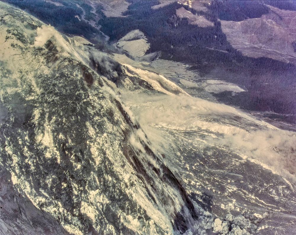
If you know what you're looking at, these become three of the most insane, unbelievable photos you'll ever see.

The luck that put three people in this spot, to capture the largest landslide in recorded history from this vantage point.

Oh, and capturing the lateral blast's start, too, in the last.
Aerial view of the initial north flank landslide on Mount St. Helens. Slide blocks from the bulge drop away and a gray dust sheet rides downslope toward the forested valley and clearcuts. Dorothy Stoffel. May 18, 1980. About 8:32–8:33 a.m. Wider view of the debris avalanche accelerating off the north side. Elongate slide blocks and fresh scarps stripe the slope as a ground-hugging dust cloud marks the moving mass into the North Fork Toutle valley. A small plume of ash and steam appears at the bottom-right margin. Dorothy Stoffel. May 18, 1980. About 8:33 a.m. Close oblique near the scarp. Jets of ash and steam punch through the collapsing rim while dense dust clouds boil from the disintegrating avalanche spilling off the north flank. May 18, 1980, about 8:33 a.m. Dorothy Stoffel.
davepetley.bsky.social
Potential extremely heavy rainfall associated with super typhoon #Ragasa could cause the Matai-an landslide dam in Taiwan to overtop in the next few days. 1,800 households have been evacuated today #typhoon #typhoonragasa
eos.org/thelandslide...
A recent photograph of the Matai'an landslide dam in Taiwan. Image from the Hualien Branch of the Forestry and Conservation Department. A recent photograph of the Matai'an landslide dam and lake in Taiwan. Image by the Forest Protection Administration of Taiwan.
Reposted by Dave Petley
rsimmon.bsky.social
Highlighting the use case for a humanitarian satellite, and the utility of more than just optical data (i.e. a high-res DEM would be extremely helpful for the analysis) cc @billfgreer.bsky.social
davepetley.bsky.social
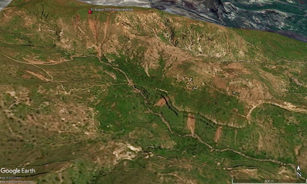
The strange case of the 31 August 2025 landslides at Tarasin in Darfur, Sudan - >1,000 people were widely reported to have died in this event. Examination of @planet.com satellite imagery casts significant doubt on this interpretation, suggesting a much lower loss of life.
eos.org/thelandslide...
Satellite image of the aftermath of the 31 August 2025 landslides in Sudan. Planet image draped onto the Google Earth DEM. Image copyright Planet, used with permission. Image dated 6 September 2025.
Reposted by Dave Petley
subfossilguy.bsky.social
CRAZY rock avalanche reaching infrastructure between Göschenen et Andermatt (UR) this morning! 😱

Look the size of those boulders that stop on the roof of the protective structure (at 1315 m asl)! 😲

Source:
www.blick.ch/fr/suisse/on...
davepetley.bsky.social
The strange case of the 31 August 2025 landslides at Tarasin in Darfur, Sudan - >1,000 people were widely reported to have died in this event. Examination of @planet.com satellite imagery casts significant doubt on this interpretation, suggesting a much lower loss of life.
eos.org/thelandslide...
Satellite image of the aftermath of the 31 August 2025 landslides in Sudan. Planet image draped onto the Google Earth DEM. Image copyright Planet, used with permission. Image dated 6 September 2025.