


mh370.io, compiled by Don Thompson
@mh370.io
Micro-blog documenting the renewed, 2025, search for MH370, the Boeing 777-2H6ER/reg 9M-MRO lost on Mar 8th 2014. Don is one of the founding contributors of the Independent Group.
Pls use Signal for chat, username: X35200217.08
Pls use Signal for chat, username: X35200217.08
Showing progress for Armada 78 05 towards the AllenX/Philippines National Museum marine archaelogical survey in San Bernardino Strait.
Estimated present position in Sulu Sea, south of Tubbataha Reefs Nat'l Park and ETA in the Strait on Friday, late morning local time.
Map: BigOceanData.com
Estimated present position in Sulu Sea, south of Tubbataha Reefs Nat'l Park and ETA in the Strait on Friday, late morning local time.
Map: BigOceanData.com

November 12, 2025 at 11:40 PM
Showing progress for Armada 78 05 towards the AllenX/Philippines National Museum marine archaelogical survey in San Bernardino Strait.
Estimated present position in Sulu Sea, south of Tubbataha Reefs Nat'l Park and ETA in the Strait on Friday, late morning local time.
Map: BigOceanData.com
Estimated present position in Sulu Sea, south of Tubbataha Reefs Nat'l Park and ETA in the Strait on Friday, late morning local time.
Map: BigOceanData.com
While it's photography rather than cartography this image from the International Space Station does illustrate geographic information: light sources NW Europe, including North Sea oil & gas platforms.
I'm also drawn to it as I can recognise the dot that is the town I call home.
#30DayMapChallenge
I'm also drawn to it as I can recognise the dot that is the town I call home.
#30DayMapChallenge

November 11, 2025 at 11:14 AM
While it's photography rather than cartography this image from the International Space Station does illustrate geographic information: light sources NW Europe, including North Sea oil & gas platforms.
I'm also drawn to it as I can recognise the dot that is the town I call home.
#30DayMapChallenge
I'm also drawn to it as I can recognise the dot that is the town I call home.
#30DayMapChallenge
Armada 86 05 voyage to Philippines San Bernardino Strait continues. Illustrating with Marine Traffic's simple route forecast tool, the indicated distance to go suggests 600NM to run, arrival Friday morning local time.
14 days in the SBS area then expected southbound to renew #MH370 search.
⬇️
14 days in the SBS area then expected southbound to renew #MH370 search.
⬇️

November 11, 2025 at 10:52 AM
Armada 86 05 voyage to Philippines San Bernardino Strait continues. Illustrating with Marine Traffic's simple route forecast tool, the indicated distance to go suggests 600NM to run, arrival Friday morning local time.
14 days in the SBS area then expected southbound to renew #MH370 search.
⬇️
14 days in the SBS area then expected southbound to renew #MH370 search.
⬇️
#OceanInfinity Armada 86 05 has departed Singapore bound for the Philippines San Bernardino Strait.
AIS is showing ETA Nov 17th, however, present speed & distance to go suggests only 5 days to the Strait. Of course, arrival in the Strait doesn't necessarily imply an immediate need to dock.
⬇️
AIS is showing ETA Nov 17th, however, present speed & distance to go suggests only 5 days to the Strait. Of course, arrival in the Strait doesn't necessarily imply an immediate need to dock.
⬇️
November 8, 2025 at 10:48 AM
#OceanInfinity Armada 86 05 has departed Singapore bound for the Philippines San Bernardino Strait.
AIS is showing ETA Nov 17th, however, present speed & distance to go suggests only 5 days to the Strait. Of course, arrival in the Strait doesn't necessarily imply an immediate need to dock.
⬇️
AIS is showing ETA Nov 17th, however, present speed & distance to go suggests only 5 days to the Strait. Of course, arrival in the Strait doesn't necessarily imply an immediate need to dock.
⬇️
Preparation for #MH370 renewed search.
Ocean Infinity's Armada 86 05 is manoeuvring into a Singapore harbour basin where Mooreast & ST Engineering are located.
Mooreast has previously provided mobilisation services for Armada vessels.
But first, a wreck survey is scheduled with #AllenX.
Ocean Infinity's Armada 86 05 is manoeuvring into a Singapore harbour basin where Mooreast & ST Engineering are located.
Mooreast has previously provided mobilisation services for Armada vessels.
But first, a wreck survey is scheduled with #AllenX.
November 5, 2025 at 1:18 AM
A short clip from late August of Armada 86 05 & 06 during final stages of completion at the Vard facility in Vung Tau, VN.
Armada 86 05 is, at present, enroute to Singapore and is then expected to join the AllenX team for the San Bernadino Strait (PH) wrecks survey, weather permitting.
Armada 86 05 is, at present, enroute to Singapore and is then expected to join the AllenX team for the San Bernadino Strait (PH) wrecks survey, weather permitting.
November 3, 2025 at 10:18 AM
A short clip from late August of Armada 86 05 & 06 during final stages of completion at the Vard facility in Vung Tau, VN.
Armada 86 05 is, at present, enroute to Singapore and is then expected to join the AllenX team for the San Bernadino Strait (PH) wrecks survey, weather permitting.
Armada 86 05 is, at present, enroute to Singapore and is then expected to join the AllenX team for the San Bernadino Strait (PH) wrecks survey, weather permitting.
Reposted by mh370.io, compiled by Don Thompson
We're maintaining a watch on the assets that will likely be deployed.
In the meantime, OI is contributing to a survey with Carl Allen's AllenX/Allen Exploration organisation. AllenX has teamed up with Philippines Nat'l Museum to look for wrecks in the San Bernadino Strait south of Luzon Island.
In the meantime, OI is contributing to a survey with Carl Allen's AllenX/Allen Exploration organisation. AllenX has teamed up with Philippines Nat'l Museum to look for wrecks in the San Bernadino Strait south of Luzon Island.
October 29, 2025 at 4:16 PM
We're maintaining a watch on the assets that will likely be deployed.
In the meantime, OI is contributing to a survey with Carl Allen's AllenX/Allen Exploration organisation. AllenX has teamed up with Philippines Nat'l Museum to look for wrecks in the San Bernadino Strait south of Luzon Island.
In the meantime, OI is contributing to a survey with Carl Allen's AllenX/Allen Exploration organisation. AllenX has teamed up with Philippines Nat'l Museum to look for wrecks in the San Bernadino Strait south of Luzon Island.
Reposted by mh370.io, compiled by Don Thompson

#Throwback to just last week, when the nation's deepest-diving crewed submersible ALVIN returned to Woods Hole! 🥳
The sub crossed North America by truck last week while its support ship, R/V Atlantis, undergoes maintenance on the West Coast. They're looking forward to reuniting in June!
The sub crossed North America by truck last week while its support ship, R/V Atlantis, undergoes maintenance on the West Coast. They're looking forward to reuniting in June!
October 16, 2025 at 11:07 PM
#Throwback to just last week, when the nation's deepest-diving crewed submersible ALVIN returned to Woods Hole! 🥳
The sub crossed North America by truck last week while its support ship, R/V Atlantis, undergoes maintenance on the West Coast. They're looking forward to reuniting in June!
The sub crossed North America by truck last week while its support ship, R/V Atlantis, undergoes maintenance on the West Coast. They're looking forward to reuniting in June!
Reposted by mh370.io, compiled by Don Thompson

US judge rules Trump cannot block offshore wind project, Orsted shares jump reut.rs/4pzMxiv

US judge rules Trump cannot block offshore wind project, Orsted shares jump
A federal judge on Monday granted a request by Danish offshore wind developer Orsted to restart work on the nearly finished Revolution Wind project, which President Donald Trump's administration halted last month.
reut.rs
September 22, 2025 at 6:50 PM
US judge rules Trump cannot block offshore wind project, Orsted shares jump reut.rs/4pzMxiv

“News organizations have for months said the new features, including Google's "AI Overviews," siphon traffic away from their sites, eroding advertising and subscription revenue [by as much as one third].”
Rolling Stone, Billboard owner Penske sues Google over AI overviews reut.rs/46lzkkm

Rolling Stone, Billboard owner Penske sues Google over AI overviews
The owner of Rolling Stone, Billboard and Variety sued Google on Friday, alleging the technology giant's AI summaries use its journalism without consent and reduce traffic to its websites.
reut.rs
September 14, 2025 at 8:21 AM
“News organizations have for months said the new features, including Google's "AI Overviews," siphon traffic away from their sites, eroding advertising and subscription revenue [by as much as one third].”
In more ways than one offshore wind production bears similarities to offshore oil & gas production. Vessels like these, described by @meretmarine.bsky.social, provide commissioning
& operational services for a windfarm throughout its lifetime.
#OffshoreWind #Windfarms
& operational services for a windfarm throughout its lifetime.
#OffshoreWind #Windfarms

Le Windea Clausius a été conçu par le constructeur norvégien pour les activités de l’armement allemand dans l'éolien en mer
#maritime
#maritime

Le Windea Clausius a été conçu par le constructeur norvégien pour les activités de l’armement allemand dans l'éolien en mer
go.meretmarine.com
September 9, 2025 at 5:28 PM
In more ways than one offshore wind production bears similarities to offshore oil & gas production. Vessels like these, described by @meretmarine.bsky.social, provide commissioning
& operational services for a windfarm throughout its lifetime.
#OffshoreWind #Windfarms
& operational services for a windfarm throughout its lifetime.
#OffshoreWind #Windfarms
Reposted by mh370.io, compiled by Don Thompson

Every scientist should have a page to showcase their work, vision, and mission. Initially, I thought that only celebrities could have personal websites. However, with the overwhelming noise on social media, it has become essential for every professional to have their own space.
jadsonjall.com
jadsonjall.com

June 16, 2025 at 2:39 PM
Every scientist should have a page to showcase their work, vision, and mission. Initially, I thought that only celebrities could have personal websites. However, with the overwhelming noise on social media, it has become essential for every professional to have their own space.
jadsonjall.com
jadsonjall.com
Humans still haven't seen 99.999% of the deep seafloor
By Nell Greenfieldboyce
www.npr.org/2025/05/07/n...
By Nell Greenfieldboyce
www.npr.org/2025/05/07/n...
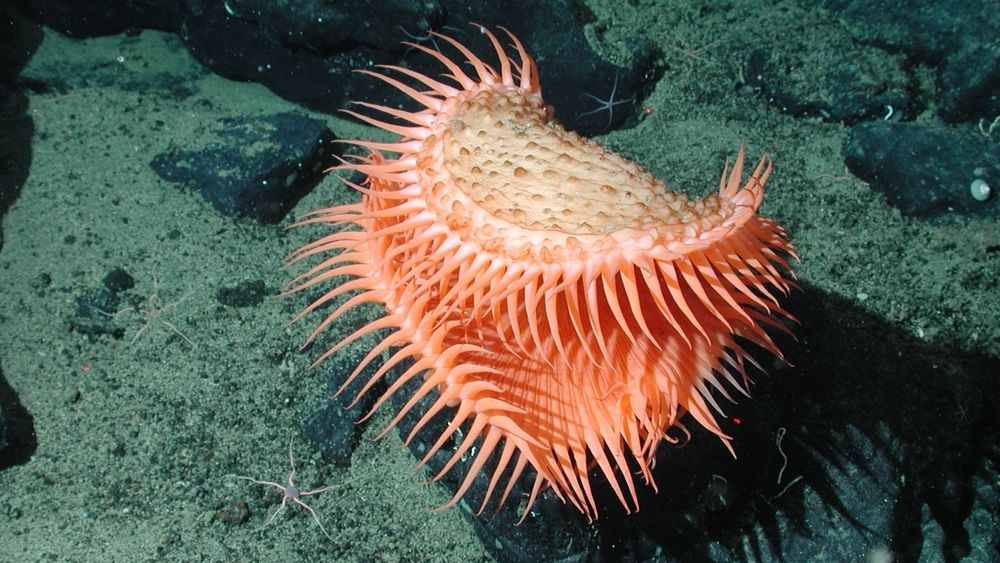
Humans still haven't seen 99.999% of the deep seafloor
Human eyes have only seen a tiny, tiny, tiny fraction of the areas of the world that are covered by deep water. Scientists want to change how they explore these regions.
www.npr.org
May 12, 2025 at 9:54 AM
Humans still haven't seen 99.999% of the deep seafloor
By Nell Greenfieldboyce
www.npr.org/2025/05/07/n...
By Nell Greenfieldboyce
www.npr.org/2025/05/07/n...
Reposted by mh370.io, compiled by Don Thompson

Reposted by mh370.io, compiled by Don Thompson

Coming up MONDAY! Mapping the Deep, a book talk with Deep-sea Dawn, @deepseadawn.bsky.social!
Details and registration here: ceoas.oregonstate.edu/mapping-deep
Details and registration here: ceoas.oregonstate.edu/mapping-deep
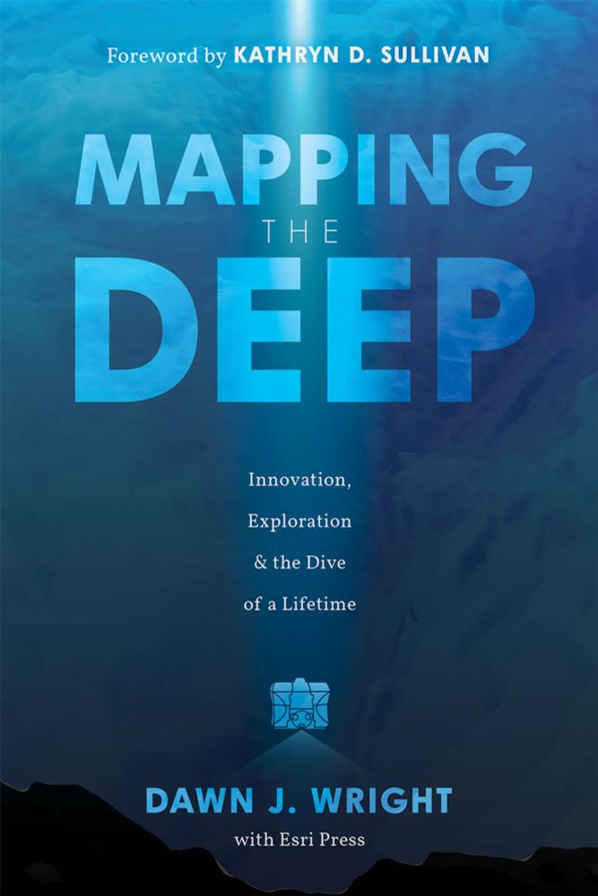
Mapping the Deep: A Book Talk with Dawn Wright | College of Earth, Ocean, and Atmospheric Sciences
ceoas.oregonstate.edu
April 4, 2025 at 5:46 PM
Coming up MONDAY! Mapping the Deep, a book talk with Deep-sea Dawn, @deepseadawn.bsky.social!
Details and registration here: ceoas.oregonstate.edu/mapping-deep
Details and registration here: ceoas.oregonstate.edu/mapping-deep
Reposted by mh370.io, compiled by Don Thompson

🌊 ⚒️

Not much attention is paid to the economics of deep-sea mining. It’s taken for granted that, whatever the ecological harms may be, the business case is sound.
Turns out that's not true. 🧪
Turns out that's not true. 🧪

The Dubious Economics of Deep-Sea Mining
Environment aside, is it just a bad investment?
nautil.us
April 2, 2025 at 3:19 AM
🌊 ⚒️
Reposted by mh370.io, compiled by Don Thompson

Victor Iannello
Steve Kent has published an excellent video explaining why WSPR tracking of MH370 is complete rubbish. He supplies the scientific rigor that is absent in the WSPR proponents' papers.
m.youtube.com/watch?v=_Uil...
Steve Kent has published an excellent video explaining why WSPR tracking of MH370 is complete rubbish. He supplies the scientific rigor that is absent in the WSPR proponents' papers.
m.youtube.com/watch?v=_Uil...
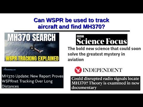
Can WSPR be used to track aircraft and find MH370?
YouTube video by sk999 sk999
m.youtube.com
March 26, 2025 at 1:01 AM
Victor Iannello
Steve Kent has published an excellent video explaining why WSPR tracking of MH370 is complete rubbish. He supplies the scientific rigor that is absent in the WSPR proponents' papers.
m.youtube.com/watch?v=_Uil...
Steve Kent has published an excellent video explaining why WSPR tracking of MH370 is complete rubbish. He supplies the scientific rigor that is absent in the WSPR proponents' papers.
m.youtube.com/watch?v=_Uil...
Reposted by mh370.io, compiled by Don Thompson
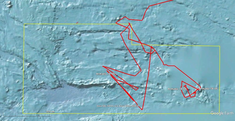
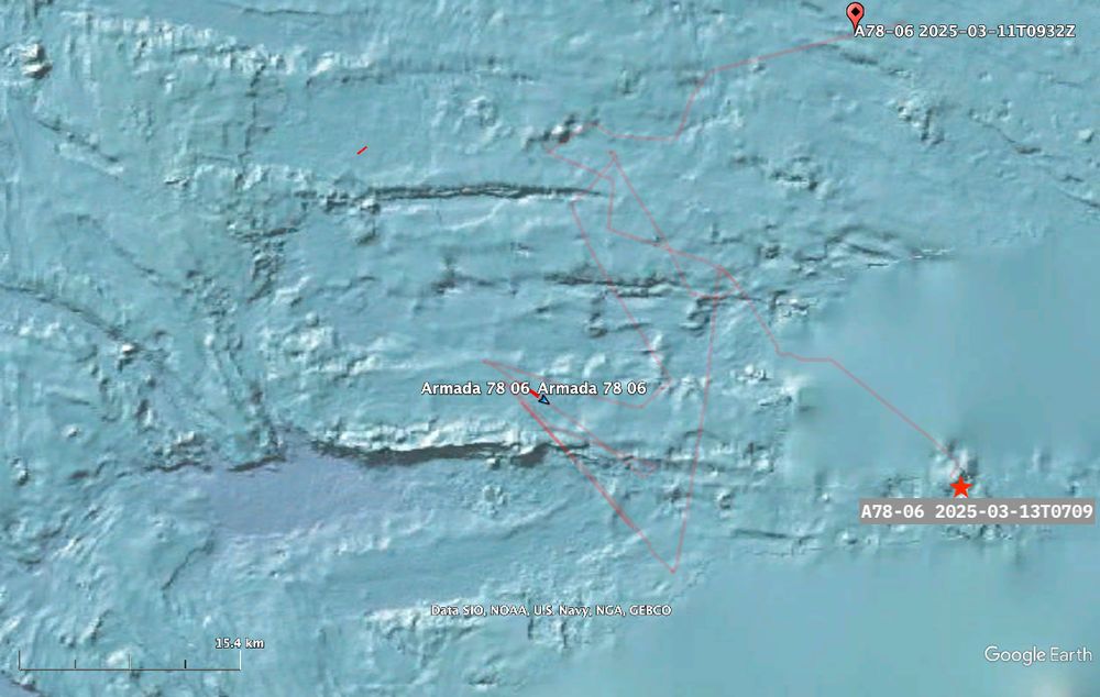
Ocean Infinity's Armada 78 06 vessel continues its search for the seafloor debris field of #MH370. Images below show the broader features of the present search & A78-06's track as it follows AUVs. The AUV endurance will dictate recoveries over the next 24hrs.
Refer to ALT text for more detail.
Refer to ALT text for more detail.
March 14, 2025 at 11:56 AM
Ocean Infinity's Armada 78 06 vessel continues its search for the seafloor debris field of #MH370. Images below show the broader features of the present search & A78-06's track as it follows AUVs. The AUV endurance will dictate recoveries over the next 24hrs.
Refer to ALT text for more detail.
Refer to ALT text for more detail.
March 14, 2025 at 11:56 AM
Ocean Infinity's Armada 78 06 vessel continues its search for the seafloor debris field of #MH370. Images below show the broader features of the present search & A78-06's track as it follows AUVs. The AUV endurance will dictate recoveries over the next 24hrs.
Refer to ALT text for more detail.
Refer to ALT text for more detail.
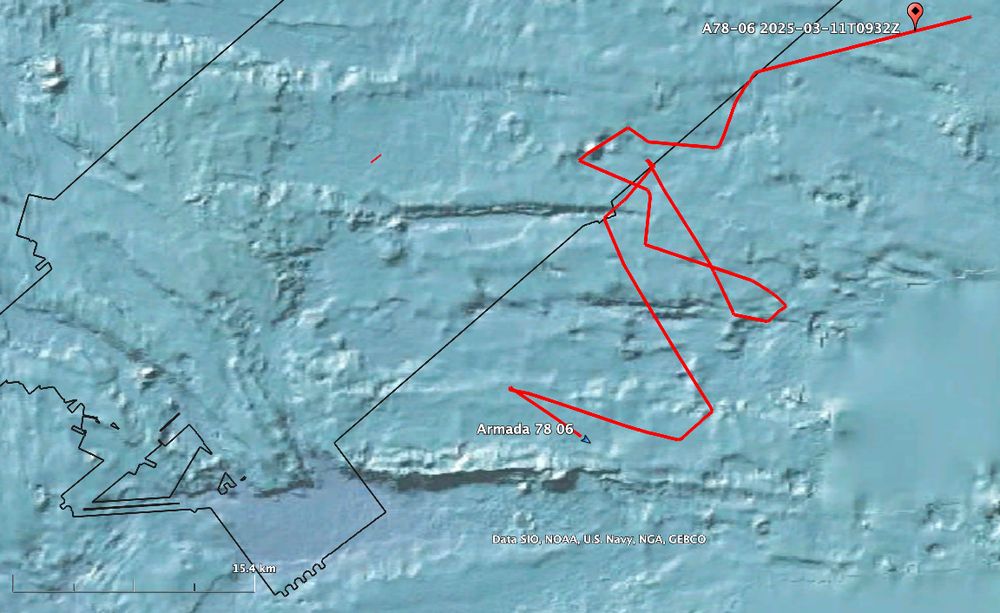
A brief update on progress by Armada 78 06 for #MH370 search this morning, 13th March.
AUVs continue to acquire seafloor imagery using side scan sonar over this particularly difficult region.
Note the, apparently, blurred areas in the image - these are low res from SRTM dataset, not local MBES.
⏹️
AUVs continue to acquire seafloor imagery using side scan sonar over this particularly difficult region.
Note the, apparently, blurred areas in the image - these are low res from SRTM dataset, not local MBES.
⏹️
March 13, 2025 at 8:15 AM
A brief update on progress by Armada 78 06 for #MH370 search this morning, 13th March.
AUVs continue to acquire seafloor imagery using side scan sonar over this particularly difficult region.
Note the, apparently, blurred areas in the image - these are low res from SRTM dataset, not local MBES.
⏹️
AUVs continue to acquire seafloor imagery using side scan sonar over this particularly difficult region.
Note the, apparently, blurred areas in the image - these are low res from SRTM dataset, not local MBES.
⏹️
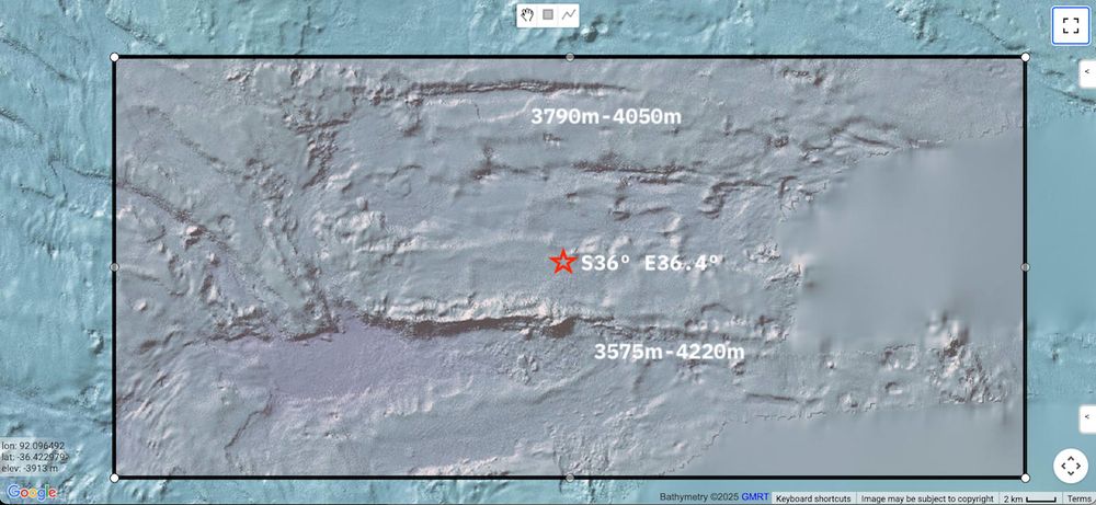
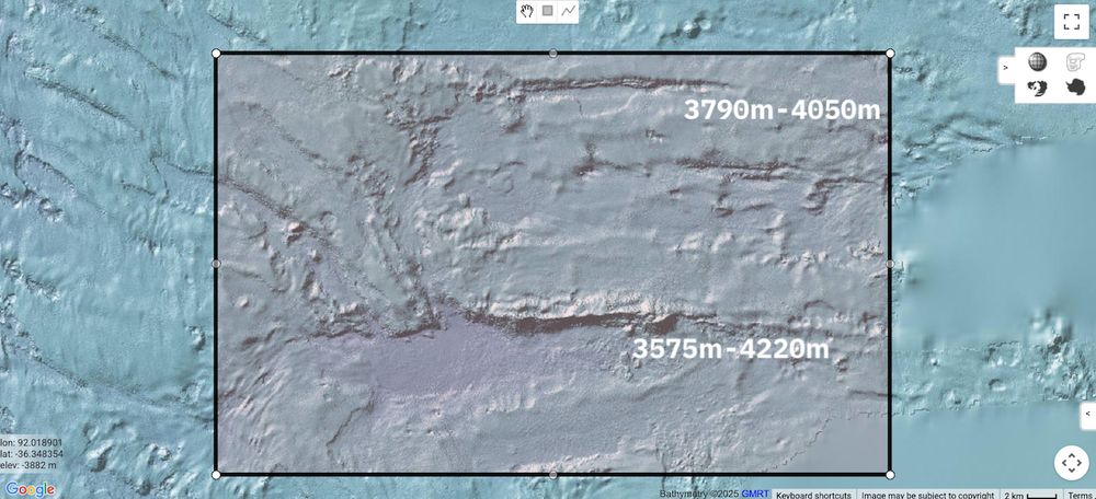
Ocean Infinity's 2nd 'swing' to locate #MH370 underway. The bathymetry for the present work area shows E-W oriented escarpments.
Black boundary line depicts the extent of Ocean Infinity's 2018 seafloor search campaign.
Vessel track & bathymetry, centred S36.4º E92.0º, view approx 60km x 36km.
⬇️
Black boundary line depicts the extent of Ocean Infinity's 2018 seafloor search campaign.
Vessel track & bathymetry, centred S36.4º E92.0º, view approx 60km x 36km.
⬇️
March 12, 2025 at 10:10 AM
Ocean Infinity's 2nd 'swing' to locate #MH370 underway. The bathymetry for the present work area shows E-W oriented escarpments.
Black boundary line depicts the extent of Ocean Infinity's 2018 seafloor search campaign.
Vessel track & bathymetry, centred S36.4º E92.0º, view approx 60km x 36km.
⬇️
Black boundary line depicts the extent of Ocean Infinity's 2018 seafloor search campaign.
Vessel track & bathymetry, centred S36.4º E92.0º, view approx 60km x 36km.
⬇️
Authoritative commentary concerning the search for #MH370 can be read at mh370.radiantphysics.com.
mh370.radiantphysics.com
March 11, 2025 at 9:17 AM
Authoritative commentary concerning the search for #MH370 can be read at mh370.radiantphysics.com.
#MH370 The perils of predictions. This renewed search has both been months in the preparation, first spoken of with some certainty a year ago, and also fraught with official ambiguity in Malaysia.
⬇️
⬇️
March 11, 2025 at 9:13 AM
#MH370 The perils of predictions. This renewed search has both been months in the preparation, first spoken of with some certainty a year ago, and also fraught with official ambiguity in Malaysia.
⬇️
⬇️
Reposted by mh370.io, compiled by Don Thompson

I remember, decades ago, a young Liam Smeeth running into my office saying “we’ve got the results of the analysis: MMR vaccine doesn’t cause autism”. I gave him a high five and told him to get writing that paper.
March 9, 2025 at 2:39 PM
I remember, decades ago, a young Liam Smeeth running into my office saying “we’ve got the results of the analysis: MMR vaccine doesn’t cause autism”. I gave him a high five and told him to get writing that paper.