Baoning Wu
@baoningwu.bsky.social
Earthquake modeler, part-time seismologist, current post-doc at UC San Diego, former post-doc at USC, and PhD at UC Riverside.
Reposted by Baoning Wu

@baoningwu.bsky.social Baoning Wu and Jeena Yun attended the International Joint Workshop on Slow-to-Fast Earthquakes in Japan as recipients of the 2025 Paul Andrew Spudich Travel Grant. Learn more about their experiences and how you can apply in Feb 2026 www.seismosoc.org/news/paul-an... ⚒️🧪

November 6, 2025 at 7:02 PM
@baoningwu.bsky.social Baoning Wu and Jeena Yun attended the International Joint Workshop on Slow-to-Fast Earthquakes in Japan as recipients of the 2025 Paul Andrew Spudich Travel Grant. Learn more about their experiences and how you can apply in Feb 2026 www.seismosoc.org/news/paul-an... ⚒️🧪
Slow Slip in the Cascadia Subduction Zone: Thinking Outside the Plane - Sammis - 2025 - Journal of Geophysical Research: Solid Earth - Wiley Online Library agupubs.onlinelibrary.wiley.com/doi/full/10....

Slow Slip in the Cascadia Subduction Zone: Thinking Outside the Plane
Large episodic slow slip events in Cascadia can be modeled as stick-slip at the interface between a viscoelastic layer above an elastic layer
The model is motivated by (a) slip in an event < plat...
agupubs.onlinelibrary.wiley.com
October 4, 2025 at 6:23 AM
Slow Slip in the Cascadia Subduction Zone: Thinking Outside the Plane - Sammis - 2025 - Journal of Geophysical Research: Solid Earth - Wiley Online Library agupubs.onlinelibrary.wiley.com/doi/full/10....
Reposted by Baoning Wu
Could drought explain why the southern San Andreas fault has been quiet for more than 300 years? A new #SRL study explores this question, and more. ⚒️
pubs.geoscienceworld.org/ssa/srl/arti...
pubs.geoscienceworld.org/ssa/srl/arti...

August 31, 2025 at 2:00 AM
Could drought explain why the southern San Andreas fault has been quiet for more than 300 years? A new #SRL study explores this question, and more. ⚒️
pubs.geoscienceworld.org/ssa/srl/arti...
pubs.geoscienceworld.org/ssa/srl/arti...
Reposted by Baoning Wu
Tsunami video allegedly taken at Pionerskaya bay after the M8.8 Kamchatka #earthquake. HOLY SHIT! This guy and his dog are unbelievably lucky. 🧪⚒️ #geology
youtube.com/shorts/LhFQ2...
youtube.com/shorts/LhFQ2...
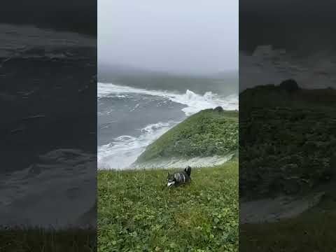
MASSIVE Tsunami Hits Pionerskaya Bay, Kamchatka, Russia (HQ)
YouTube video by 2025 Kamchatka Earthquake & Tsunami Archive
youtube.com
August 4, 2025 at 9:17 PM
Tsunami video allegedly taken at Pionerskaya bay after the M8.8 Kamchatka #earthquake. HOLY SHIT! This guy and his dog are unbelievably lucky. 🧪⚒️ #geology
youtube.com/shorts/LhFQ2...
youtube.com/shorts/LhFQ2...
Reposted by Baoning Wu

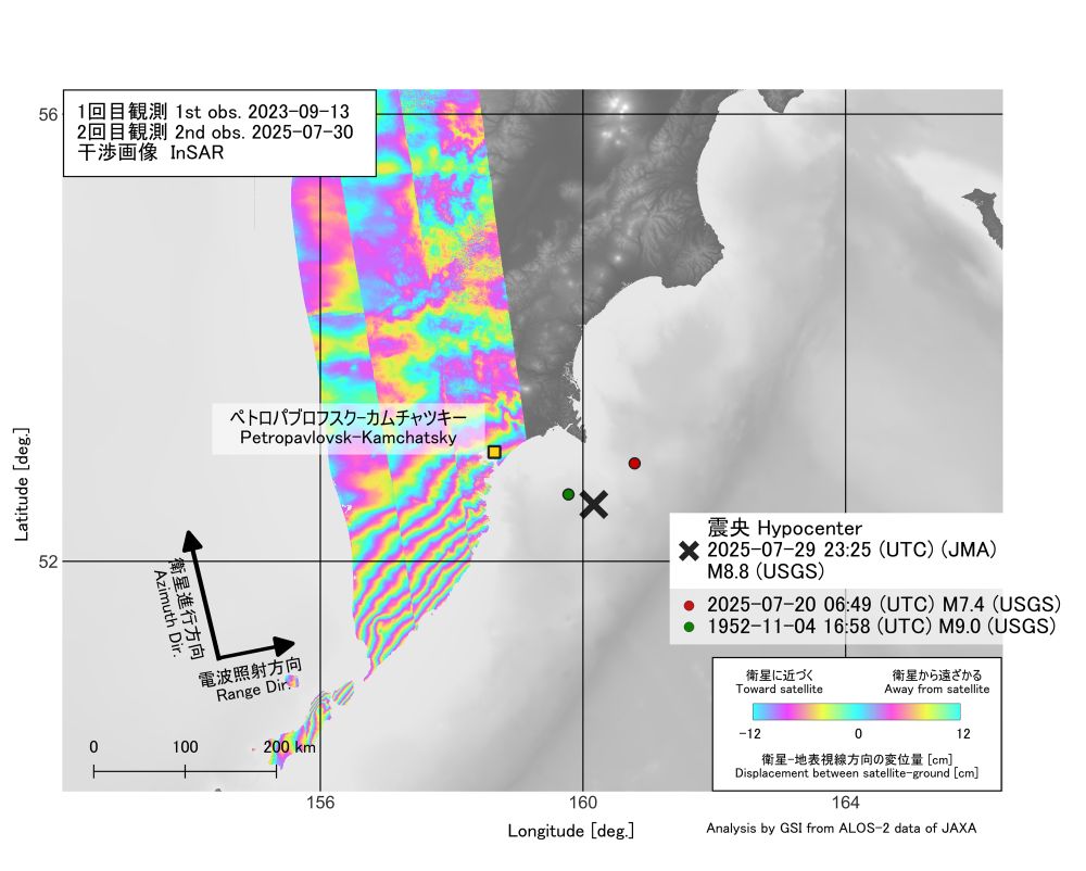
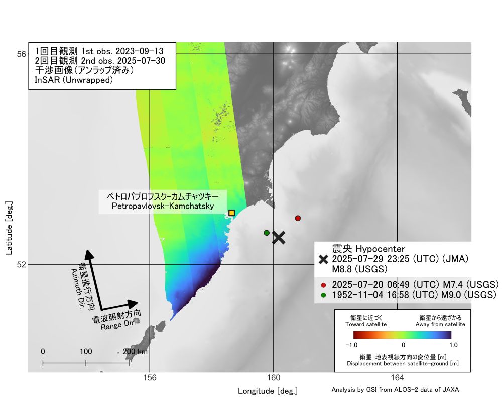
Japanese GSI published the InSAR result of ALOS-2. It may be helpful for the interpretation.
www.gsi.go.jp/cais/topic20...
www.gsi.go.jp/cais/topic20...
August 1, 2025 at 10:19 AM
Japanese GSI published the InSAR result of ALOS-2. It may be helpful for the interpretation.
www.gsi.go.jp/cais/topic20...
www.gsi.go.jp/cais/topic20...
Reposted by Baoning Wu

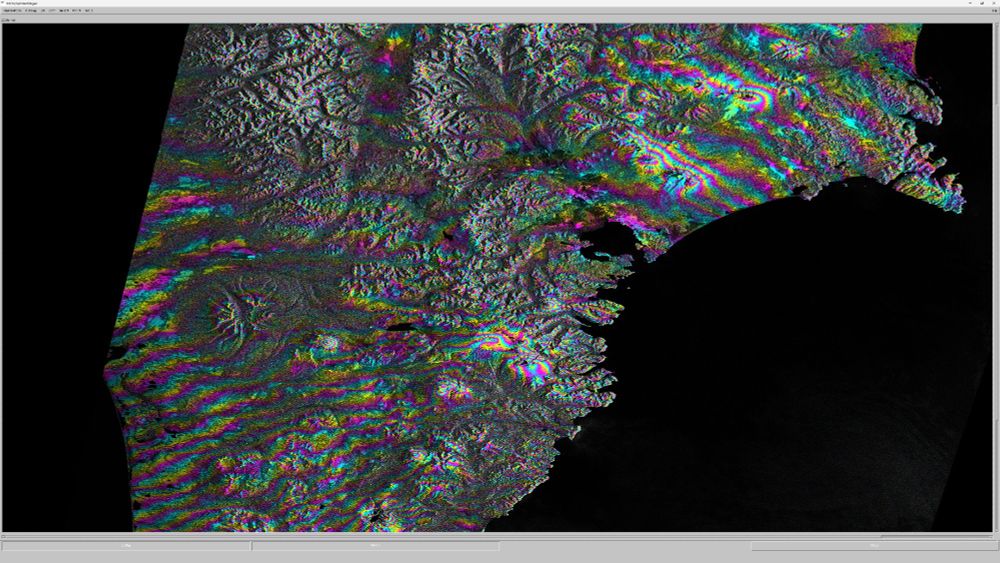
First Sentinel-1 interferogram from southern Kamchatka! Lots of what I am assuming are tropospheric signals (e.g. over the volcanoes), but I also see long-wavelength fringes that change in azimuth from the NE (~shore-perpendicular) to the SW (~shore-parallel). Optimistic it could be the earthquake!
August 1, 2025 at 9:19 AM
First Sentinel-1 interferogram from southern Kamchatka! Lots of what I am assuming are tropospheric signals (e.g. over the volcanoes), but I also see long-wavelength fringes that change in azimuth from the NE (~shore-perpendicular) to the SW (~shore-parallel). Optimistic it could be the earthquake!
Reposted by Baoning Wu

Literature regarding the 1923 and 1952 #Kamchatka #earthquakes are available at these links:
1923-02-03: www.isc.ac.uk/cgi-bin/Form...
1952-11-04: www.isc.ac.uk/cgi-bin/Form...
1923-02-03: www.isc.ac.uk/cgi-bin/Form...
1952-11-04: www.isc.ac.uk/cgi-bin/Form...
July 30, 2025 at 9:03 AM
Literature regarding the 1923 and 1952 #Kamchatka #earthquakes are available at these links:
1923-02-03: www.isc.ac.uk/cgi-bin/Form...
1952-11-04: www.isc.ac.uk/cgi-bin/Form...
1923-02-03: www.isc.ac.uk/cgi-bin/Form...
1952-11-04: www.isc.ac.uk/cgi-bin/Form...
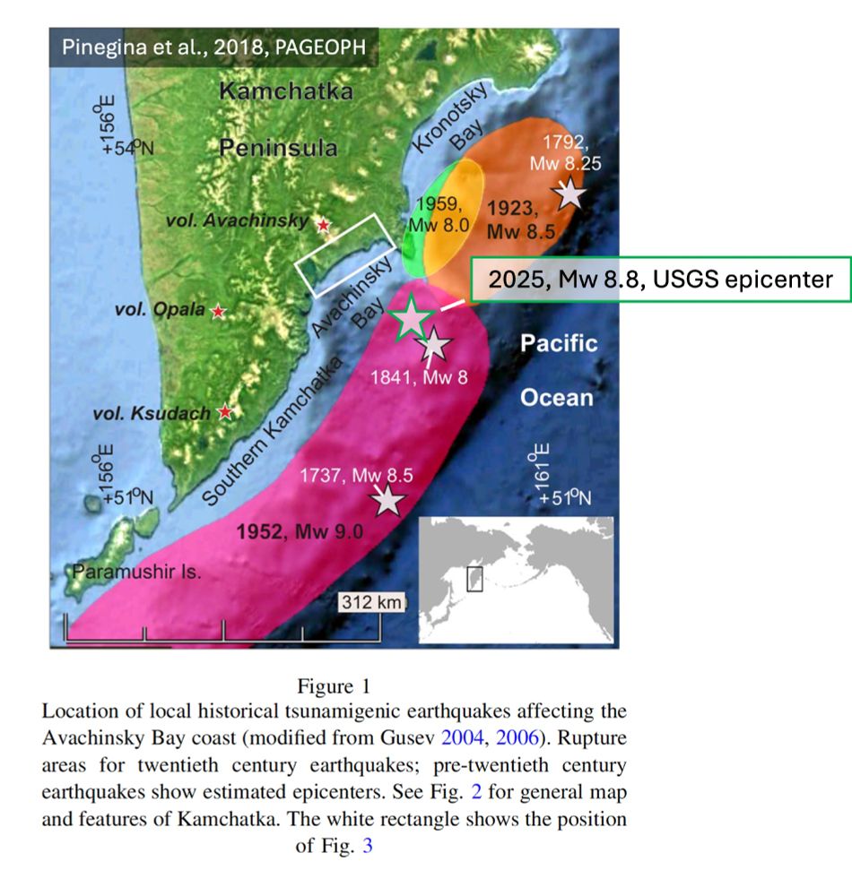
Quickly plot the rough location of the 2025 Mw8.8 Kamchatka earthquake (USGS hypocenter) on Figure 1 in Pinegina et al. (2018). I wonder if the 2025 event re-rupture the northern rupture of the 1952 Mw9.0 event? Also, did the 2025 event rupture across the "segment boundary" at ~N53?
rdcu.be/eyrre
rdcu.be/eyrre
July 30, 2025 at 4:36 AM
Quickly plot the rough location of the 2025 Mw8.8 Kamchatka earthquake (USGS hypocenter) on Figure 1 in Pinegina et al. (2018). I wonder if the 2025 event re-rupture the northern rupture of the 1952 Mw9.0 event? Also, did the 2025 event rupture across the "segment boundary" at ~N53?
rdcu.be/eyrre
rdcu.be/eyrre
Reposted by Baoning Wu

Azúa, K., Ide, S., Yano, S., Ruiz, S., Sugioka, H., Shiobara, H., et al. (2025). Shallow tectonic tremors reveal the beginning of the slab window at the Chilean triple junction. Geophysical Research Letters, 52, e2025GL115019. doi.org/10.1029/2025...

Shallow Tectonic Tremors Reveal the Beginning of the Slab Window at the Chilean Triple Junction
We detected ∼500 shallow tectonic tremors at the Chilean Triple Junction (CTJ), using nearly two continuous years of ocean bottom seismometers data A gap between tremors and fast seismicity is ob...
doi.org
July 29, 2025 at 9:11 PM
Azúa, K., Ide, S., Yano, S., Ruiz, S., Sugioka, H., Shiobara, H., et al. (2025). Shallow tectonic tremors reveal the beginning of the slab window at the Chilean triple junction. Geophysical Research Letters, 52, e2025GL115019. doi.org/10.1029/2025...
One of the best tsunami education I have seen video on YouTube. Very intuitive animation, especially the parts on wave shoaling and how waves breaks at the coast line.
youtube.com/watch?v=piH4...
youtube.com/watch?v=piH4...
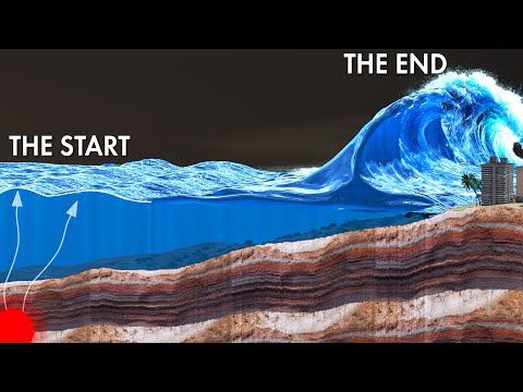
The CRUEL Physics behind Tsunamis!
YouTube video by Sabin Civil Engineering
youtube.com
July 6, 2025 at 3:33 PM
One of the best tsunami education I have seen video on YouTube. Very intuitive animation, especially the parts on wave shoaling and how waves breaks at the coast line.
youtube.com/watch?v=piH4...
youtube.com/watch?v=piH4...
Reposted by Baoning Wu
Apparently surface rupture during the Myanmar 2025. I'm very surprised by the weak shaking along the rupture. I'm not sure if this is the main rupture (I would say no - nonetheless, VERY COOL). Author unknown, location Thazi (to be confirmed)
May 12, 2025 at 2:18 AM
Apparently surface rupture during the Myanmar 2025. I'm very surprised by the weak shaking along the rupture. I'm not sure if this is the main rupture (I would say no - nonetheless, VERY COOL). Author unknown, location Thazi (to be confirmed)
Reposted by Baoning Wu
I am speechless...
>> First fault movement ever filmed. M7.9 surface rupture filmed near Thazi, Myanmar
m.youtube.com/watch?v=77ub...
>> First fault movement ever filmed. M7.9 surface rupture filmed near Thazi, Myanmar
m.youtube.com/watch?v=77ub...
First fault movement ever filmed. M7.9 surface rupture filmed near Thazi, Myanmar
YouTube video by 2025 Sagaing Earthquake Archive
m.youtube.com
May 12, 2025 at 1:17 AM
I am speechless...
>> First fault movement ever filmed. M7.9 surface rupture filmed near Thazi, Myanmar
m.youtube.com/watch?v=77ub...
>> First fault movement ever filmed. M7.9 surface rupture filmed near Thazi, Myanmar
m.youtube.com/watch?v=77ub...
Reposted by Baoning Wu

If you are near the @scrippsocean.bsky.social in La Jolla, come by to the Ritter Memorial Fellowship Lecture tomorrow at 3 pm, I will be talking about the emergence of the German Maritime Observatory (Deutsche #Seewarte).

April 20, 2025 at 4:10 PM
If you are near the @scrippsocean.bsky.social in La Jolla, come by to the Ritter Memorial Fellowship Lecture tomorrow at 3 pm, I will be talking about the emergence of the German Maritime Observatory (Deutsche #Seewarte).
Reposted by Baoning Wu
The whole #MyanmarEarthquake rupture in one interferogram! This is three consecutive wide swath frames of ALOS-2 data, provided by JAXA through agreement with NASA. The line-of-sight (LOS) is ~perpendicular to fault strike, so most of what you see is vertical motion at bends and steps of the fault.

April 2, 2025 at 11:14 PM
The whole #MyanmarEarthquake rupture in one interferogram! This is three consecutive wide swath frames of ALOS-2 data, provided by JAXA through agreement with NASA. The line-of-sight (LOS) is ~perpendicular to fault strike, so most of what you see is vertical motion at bends and steps of the fault.
Reposted by Baoning Wu
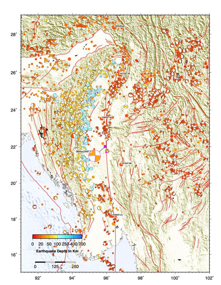
A historical seismicity map shows several #earthquakes of similar size to today’s M7.7 in Myanmar occurred in the region in the early 20th century, but this section of the Sagaing fault probably hasn’t ruptured since 1839 🧪⚒️
March 28, 2025 at 9:16 AM
A historical seismicity map shows several #earthquakes of similar size to today’s M7.7 in Myanmar occurred in the region in the early 20th century, but this section of the Sagaing fault probably hasn’t ruptured since 1839 🧪⚒️
Reposted by Baoning Wu

📢📢 Excited to announce that the #openaccess book on "Understanding Past #Earthquakes" is out now... 🤩
So proud to have been able to contribute to this by co-authoring the chapter on Lacustrine #Paleoseismology 👩🔬📕 Happy to finally see it come to live 🥳
Check it out by clicking the link below ⬇️
So proud to have been able to contribute to this by co-authoring the chapter on Lacustrine #Paleoseismology 👩🔬📕 Happy to finally see it come to live 🥳
Check it out by clicking the link below ⬇️

Lacustrine Records of Past Seismic Shaking
Reliable seismic hazard analysis builds upon a robust reconstruction of spatiotemporal rupture variability over multi-millennial timescales. Lacustrine sediment sequences can provide long and complete...
link.springer.com
February 20, 2025 at 9:31 AM
📢📢 Excited to announce that the #openaccess book on "Understanding Past #Earthquakes" is out now... 🤩
So proud to have been able to contribute to this by co-authoring the chapter on Lacustrine #Paleoseismology 👩🔬📕 Happy to finally see it come to live 🥳
Check it out by clicking the link below ⬇️
So proud to have been able to contribute to this by co-authoring the chapter on Lacustrine #Paleoseismology 👩🔬📕 Happy to finally see it come to live 🥳
Check it out by clicking the link below ⬇️
Reposted by Baoning Wu

#EarthquakeReport for M7.6 #Earthquake #Sismo #Terremoto near #CaymanIsland
Left-lateral strike-slip earthquake along Swan Island fault
#Tsunami observation at Isla Mujeres
See 2020 report for tectonic background
earthjay.com?p=9322
earthquake.usgs.gov/earthquakes/...
Left-lateral strike-slip earthquake along Swan Island fault
#Tsunami observation at Isla Mujeres
See 2020 report for tectonic background
earthjay.com?p=9322
earthquake.usgs.gov/earthquakes/...


February 9, 2025 at 3:55 AM
#EarthquakeReport for M7.6 #Earthquake #Sismo #Terremoto near #CaymanIsland
Left-lateral strike-slip earthquake along Swan Island fault
#Tsunami observation at Isla Mujeres
See 2020 report for tectonic background
earthjay.com?p=9322
earthquake.usgs.gov/earthquakes/...
Left-lateral strike-slip earthquake along Swan Island fault
#Tsunami observation at Isla Mujeres
See 2020 report for tectonic background
earthjay.com?p=9322
earthquake.usgs.gov/earthquakes/...
Reposted by Baoning Wu

What began as a student project in 2016 from @scrippsocean.bsky.social alumna Allison Cusick has developed into a NASA-funded program (@fjordphyto.bsky.social) that trains tour vessel operators and “citizen scientists” to collect samples of phytoplankton in Antarctica. 🧊➡️ bit.ly/4gmsX3e

February 4, 2025 at 12:53 AM
What began as a student project in 2016 from @scrippsocean.bsky.social alumna Allison Cusick has developed into a NASA-funded program (@fjordphyto.bsky.social) that trains tour vessel operators and “citizen scientists” to collect samples of phytoplankton in Antarctica. 🧊➡️ bit.ly/4gmsX3e
Walk and think around the campus until I see this.

February 4, 2025 at 6:51 PM
Walk and think around the campus until I see this.
Crustal Structure of the Hikurangi Subduction Zone Revealed by Four Decades of Onshore‐Offshore Seismic Data: Implications for the Dimensions and Slip Behavior of the Seismogenic Zone - Bassett - 2025 - Journal of Geophysical Research: Solid Earth agupubs.onlinelibrary.wiley.com/doi/10.1029/...
Crustal Structure of the Hikurangi Subduction Zone Revealed by Four Decades of Onshore‐Offshore Seismic Data: Implications for the Dimensions and Slip Behavior of the Seismogenic Zone
Four decades of controlled-source seismic data constrain a high-resolution, regional P-wave velocity model of the Hikurangi subduction zone Spatial variability in wavespeeds reflect the tectonic ...
agupubs.onlinelibrary.wiley.com
February 4, 2025 at 3:00 AM
Crustal Structure of the Hikurangi Subduction Zone Revealed by Four Decades of Onshore‐Offshore Seismic Data: Implications for the Dimensions and Slip Behavior of the Seismogenic Zone - Bassett - 2025 - Journal of Geophysical Research: Solid Earth agupubs.onlinelibrary.wiley.com/doi/10.1029/...
Reposted by Baoning Wu

Since nobody asked, here is a map showing where polar bears have been found in Iceland after drifting over from Greenland on icebergs.

January 21, 2025 at 12:19 PM
Since nobody asked, here is a map showing where polar bears have been found in Iceland after drifting over from Greenland on icebergs.
Reposted by Baoning Wu
The JMA panel acted quickly, deciding less than 3 hours after the earthquake not to issue an advisory. www.japantimes.co.jp/news/2025/01...

Miyazaki quake falls short of triggering Nankai Trough megaquake advisory
Though Monday's temblor struck a similar area to one in August that sparked the first advisory, no such alert was issued.
www.japantimes.co.jp
January 14, 2025 at 3:46 PM
The JMA panel acted quickly, deciding less than 3 hours after the earthquake not to issue an advisory. www.japantimes.co.jp/news/2025/01...
Reposted by Baoning Wu
No words

January 8, 2025 at 7:25 AM
No words
Reposted by Baoning Wu
Super helpful app recommendation for Watchduty App to track wildfires. They even have large and small animal shelter locations called out on the maps of fire locations, which scores points in my book.

January 8, 2025 at 12:09 AM
Super helpful app recommendation for Watchduty App to track wildfires. They even have large and small animal shelter locations called out on the maps of fire locations, which scores points in my book.
Reposted by Baoning Wu