


Steve Copertino
@thestevecop.bsky.social
Operational forecaster in the private sector | Millersville University Alum | Tortured Saints fan and fan of spinning clouds
What a nice surprise that was.

November 5, 2025 at 11:44 AM
What a nice surprise that was.
Reposted by Steve Copertino

HAPPY HALLOWEEN TO ALL, INCLUDING RADICAL LEFTISTS, INCLUDING THOSE MANY PEOPLE THAT I COMPLETELY & TOTALLY DESPISE BECAUSE THEY WANT TO DESTROY AMERICA, A NOW FAILING NATION. HAPPY HALLOWEEN EVERYONE! 👻🎃
October 31, 2025 at 3:26 PM
HAPPY HALLOWEEN TO ALL, INCLUDING RADICAL LEFTISTS, INCLUDING THOSE MANY PEOPLE THAT I COMPLETELY & TOTALLY DESPISE BECAUSE THEY WANT TO DESTROY AMERICA, A NOW FAILING NATION. HAPPY HALLOWEEN EVERYONE! 👻🎃
Reposted by Steve Copertino

With #Melissa now an extratropical cyclone in the north Atlantic, here's a look at the preliminary track and intensity verification stats for the storm's 10-day lifetime.
[1/3]
[1/3]


October 31, 2025 at 4:04 PM
With #Melissa now an extratropical cyclone in the north Atlantic, here's a look at the preliminary track and intensity verification stats for the storm's 10-day lifetime.
[1/3]
[1/3]
Reposted by Steve Copertino
We wrote about the Google DeepMind AI forecast model that has been doing quite well in predicting Atlantic #hurricane tracks & intensities this year. Thanks @bmcnoldy.bsky.social @franklinjamesl.bsky.social for insights, @NOAA for working without pay:
www.nature.com/articles/d41...
🧪🌀
www.nature.com/articles/d41...
🧪🌀

This ‘impressive’ AI model predicted Hurricane Melissa’s perilous growth
An artificial-intelligence tool is helping to crack the challenge of forecasting hurricane intensity.
www.nature.com
October 29, 2025 at 8:42 PM
We wrote about the Google DeepMind AI forecast model that has been doing quite well in predicting Atlantic #hurricane tracks & intensities this year. Thanks @bmcnoldy.bsky.social @franklinjamesl.bsky.social for insights, @NOAA for working without pay:
www.nature.com/articles/d41...
🧪🌀
www.nature.com/articles/d41...
🧪🌀
Reposted by Steve Copertino
Regarding the sonde from yesterday morning with the 219-kt spot wind, highest dropsonde wind ever seen in a TC, AOML/HRD shared the raw data and I took a look this morning. They’ll have the final call, but I see nothing wrong with the ob and I suspect it’s going to hold up.

October 29, 2025 at 5:54 PM
Regarding the sonde from yesterday morning with the 219-kt spot wind, highest dropsonde wind ever seen in a TC, AOML/HRD shared the raw data and I took a look this morning. They’ll have the final call, but I see nothing wrong with the ob and I suspect it’s going to hold up.
Reposted by Steve Copertino
Thanks to some vigilant friends out there, I have a nearly-complete 87-hour radar loop of #Melissa 's approach to #Jamaica. The loop abruptly ends when the radar is lost (either loss of communication with it or loss of the actual structure).
bmcnoldy.earth.miami.edu/tropics/radar/
bmcnoldy.earth.miami.edu/tropics/radar/
October 29, 2025 at 12:03 PM
Thanks to some vigilant friends out there, I have a nearly-complete 87-hour radar loop of #Melissa 's approach to #Jamaica. The loop abruptly ends when the radar is lost (either loss of communication with it or loss of the actual structure).
bmcnoldy.earth.miami.edu/tropics/radar/
bmcnoldy.earth.miami.edu/tropics/radar/
The incoming shortwave over the Southeast will help to supercharge the poleward outflow of #Melissa over the next several hours. This may also promote additional deepening via extreme divergence aloft.
October 28, 2025 at 2:32 AM
The incoming shortwave over the Southeast will help to supercharge the poleward outflow of #Melissa over the next several hours. This may also promote additional deepening via extreme divergence aloft.
Somehow...the eye of #Melissa continues to warm. This indicates the presence of extreme subsidence which is often a sign of further deepening.
There's a legitimate chance we get below 900mb at some point overnight
There's a legitimate chance we get below 900mb at some point overnight
October 28, 2025 at 2:22 AM
Somehow...the eye of #Melissa continues to warm. This indicates the presence of extreme subsidence which is often a sign of further deepening.
There's a legitimate chance we get below 900mb at some point overnight
There's a legitimate chance we get below 900mb at some point overnight
We're very lucky to have such brave men and women putting their lives on the line to collect extremely valuable data with #Melissa.
Our satellite estimates have been running much higher than what recon has actually been finding.
Our satellite estimates have been running much higher than what recon has actually been finding.


October 28, 2025 at 2:21 AM
We're very lucky to have such brave men and women putting their lives on the line to collect extremely valuable data with #Melissa.
Our satellite estimates have been running much higher than what recon has actually been finding.
Our satellite estimates have been running much higher than what recon has actually been finding.
Reposted by Steve Copertino

The western end of Jamaica where #Melissa is projected to make landfall has the least well-built structures of anyplace on the island. Graphic is from a 2021 paper, "Poverty and hurricane risk exposure in Jamaica": www.researchgate.net/publication/...

October 28, 2025 at 1:53 AM
The western end of Jamaica where #Melissa is projected to make landfall has the least well-built structures of anyplace on the island. Graphic is from a 2021 paper, "Poverty and hurricane risk exposure in Jamaica": www.researchgate.net/publication/...
Reposted by Steve Copertino
With about 80% of the precincts reporting I've seen enough. GDMI - Google DeepMind is going to win the seat for best track model in 2025. The race for best intensity model is still too close to call, but GDMI is right there with the consensus and OFCL. Quite a remarkable campaign.


October 13, 2025 at 2:45 PM
With about 80% of the precincts reporting I've seen enough. GDMI - Google DeepMind is going to win the seat for best track model in 2025. The race for best intensity model is still too close to call, but GDMI is right there with the consensus and OFCL. Quite a remarkable campaign.
Reposted by Steve Copertino
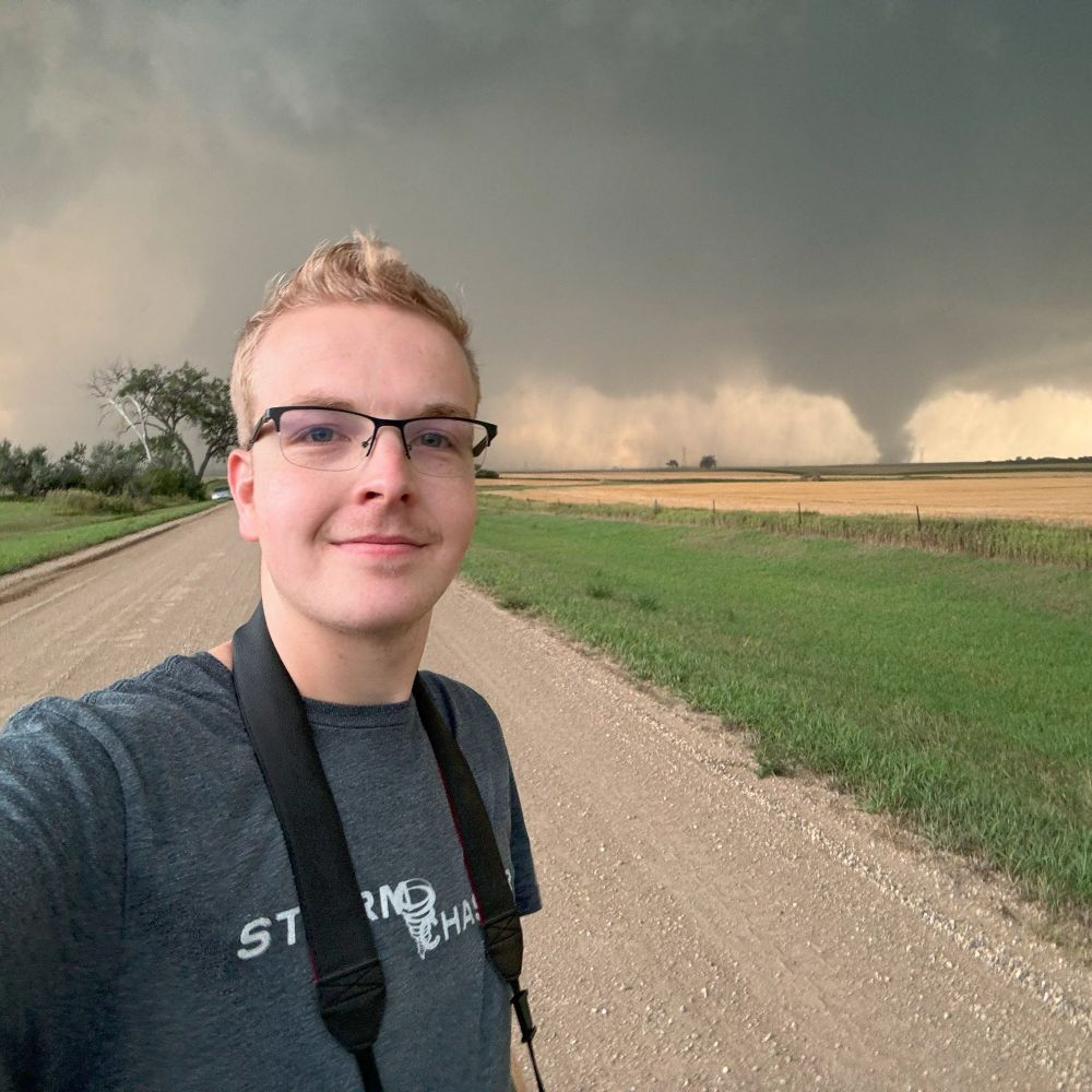
Pretty surreal to say I’ve officially documented an EF5 tornado. The first EF5 tornado since Moore 2013.
Enderlin, North Dakota - June 20, 2025.
Enderlin, North Dakota - June 20, 2025.


October 6, 2025 at 9:10 PM
Pretty surreal to say I’ve officially documented an EF5 tornado. The first EF5 tornado since Moore 2013.
Enderlin, North Dakota - June 20, 2025.
Enderlin, North Dakota - June 20, 2025.
Reposted by Steve Copertino

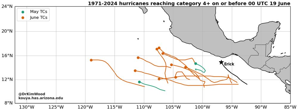
The eastern North Pacific can produce strong tropical cyclones (TCs) early in the season, but Erick's trajectory is unusual among category 4+ hurricanes for this time of year.
During 1971-2024, 2 TCs achieved this in May and 10 in June.
Now, in 2025, Erick is unlucky number thirteen.
During 1971-2024, 2 TCs achieved this in May and 10 in June.
Now, in 2025, Erick is unlucky number thirteen.
June 19, 2025 at 2:23 PM
The eastern North Pacific can produce strong tropical cyclones (TCs) early in the season, but Erick's trajectory is unusual among category 4+ hurricanes for this time of year.
During 1971-2024, 2 TCs achieved this in May and 10 in June.
Now, in 2025, Erick is unlucky number thirteen.
During 1971-2024, 2 TCs achieved this in May and 10 in June.
Now, in 2025, Erick is unlucky number thirteen.
June 19, 2025 at 10:49 AM
Reposted by Steve Copertino

Here's the same general time period and guidance from the 00z 6/16 operational ECMWF (courtesy of @burgwx.bsky.social):
June 16, 2025 at 1:32 PM
Here's the same general time period and guidance from the 00z 6/16 operational ECMWF (courtesy of @burgwx.bsky.social):
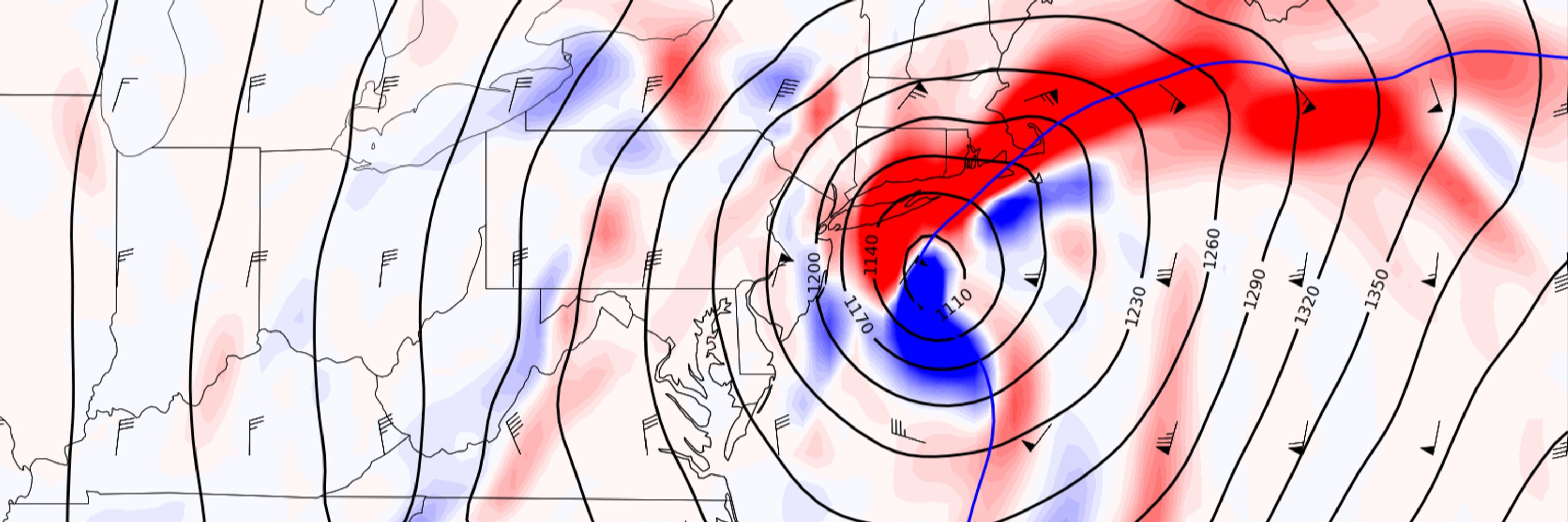
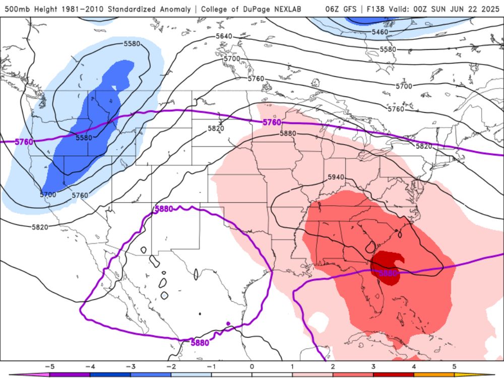
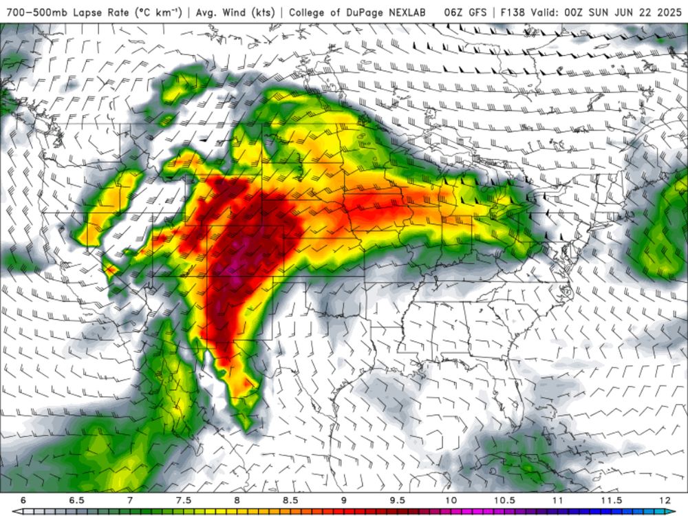
We may actually have a few solid chances at severe weather in the Northeast next week if we can get a solid EML to spill over the top of this ridge.
June 16, 2025 at 3:09 PM
We may actually have a few solid chances at severe weather in the Northeast next week if we can get a solid EML to spill over the top of this ridge.
Reposted by Steve Copertino

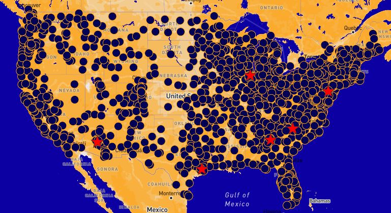
ngl this map of scheduled protests for this weekend is *wild*
June 10, 2025 at 10:26 PM
ngl this map of scheduled protests for this weekend is *wild*
Reposted by Steve Copertino
“Hard drive computers” and acting as if each wfo a) has a green screen and b) needs it to issue core products
This guy doesn’t know shit about NWS
This guy doesn’t know shit about NWS

PETERS: Will you commit to me that the forecasting office in Marquette will not cease its round the clock operation?
LUTNICK: You don't understand it yet because nobody has explained it to you. These are hard drive computers literally that nobody has seen in 25 years
PETERS: So the answer is no
LUTNICK: You don't understand it yet because nobody has explained it to you. These are hard drive computers literally that nobody has seen in 25 years
PETERS: So the answer is no
June 4, 2025 at 3:55 PM
“Hard drive computers” and acting as if each wfo a) has a green screen and b) needs it to issue core products
This guy doesn’t know shit about NWS
This guy doesn’t know shit about NWS
Reposted by Steve Copertino

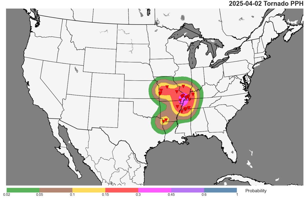
Yesterday's 30% tornado risk from the SPC already verified (obviously) and the surveys haven't even started.
Their incredible efforts and advanced lead time undoubtedly saved lives.
Their incredible efforts and advanced lead time undoubtedly saved lives.
April 3, 2025 at 4:10 PM
Yesterday's 30% tornado risk from the SPC already verified (obviously) and the surveys haven't even started.
Their incredible efforts and advanced lead time undoubtedly saved lives.
Their incredible efforts and advanced lead time undoubtedly saved lives.
Reposted by Steve Copertino

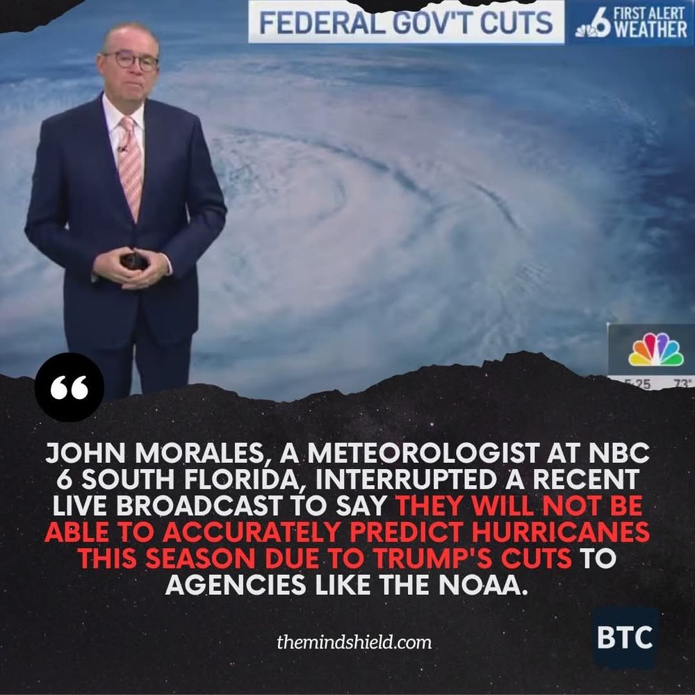
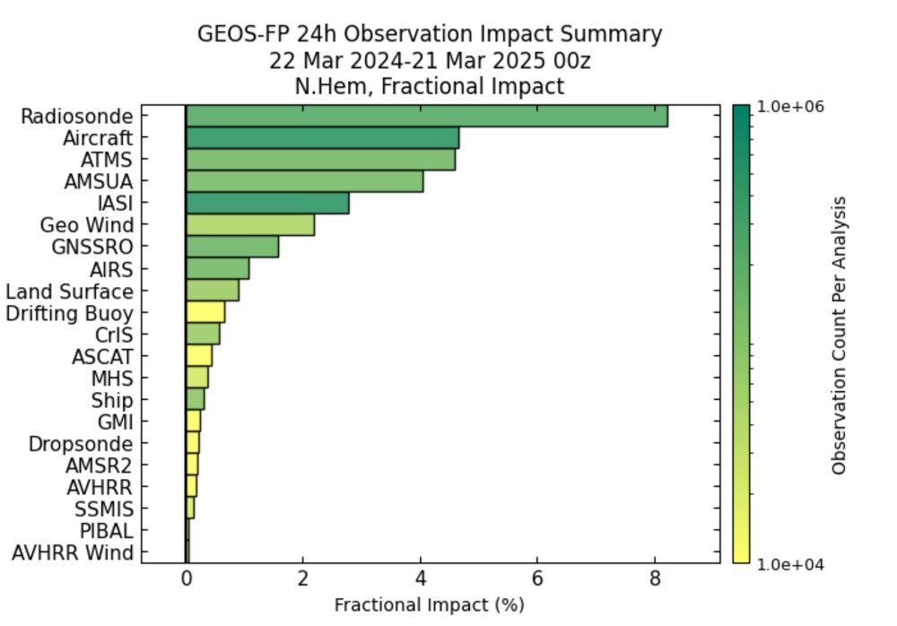
I can’t believe this is even a conversation. Shutting down radiosonde sites will cost orders of magnitude more $ via poorer forecast skill. NASA’s GMAO keeps tabs here: gmao.gsfc.nasa.gov/forecasts/sy...
March 23, 2025 at 6:26 PM
I can’t believe this is even a conversation. Shutting down radiosonde sites will cost orders of magnitude more $ via poorer forecast skill. NASA’s GMAO keeps tabs here: gmao.gsfc.nasa.gov/forecasts/sy...
Reposted by Steve Copertino

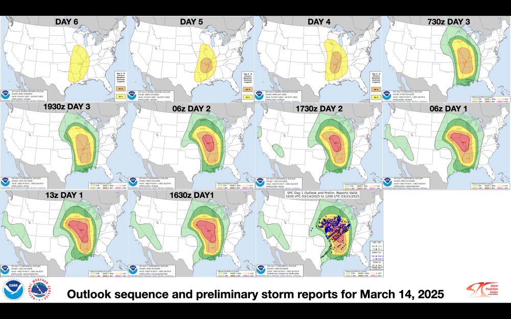
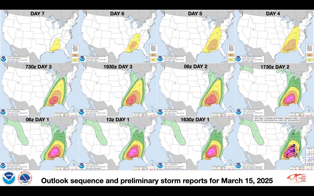
Updated outlook progression and preliminary storm reports graphics for March 14-15.
March 17, 2025 at 8:37 PM
Updated outlook progression and preliminary storm reports graphics for March 14-15.
Reposted by Steve Copertino

I miss when websites weren’t all the same and everything wasn’t monetized and everyone had their own little blog and search engines weren’t full of slop and the internet was fun
March 16, 2025 at 2:20 AM
I miss when websites weren’t all the same and everything wasn’t monetized and everyone had their own little blog and search engines weren’t full of slop and the internet was fun
My Twitter account was hacked. Please don't interact with it for now 🙄
March 15, 2025 at 2:26 PM
My Twitter account was hacked. Please don't interact with it for now 🙄
Reposted by Steve Copertino

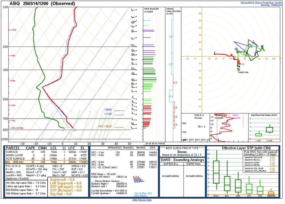
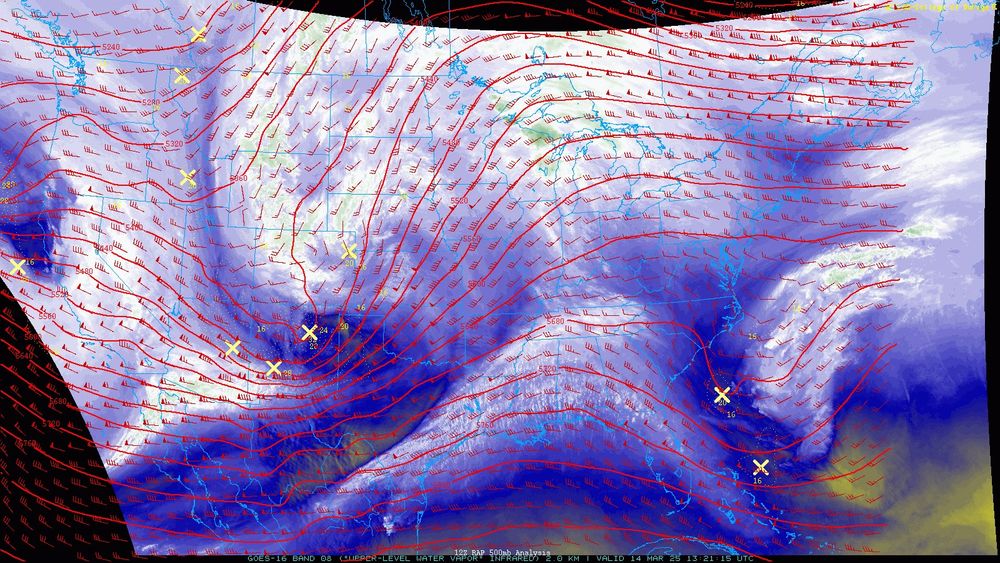
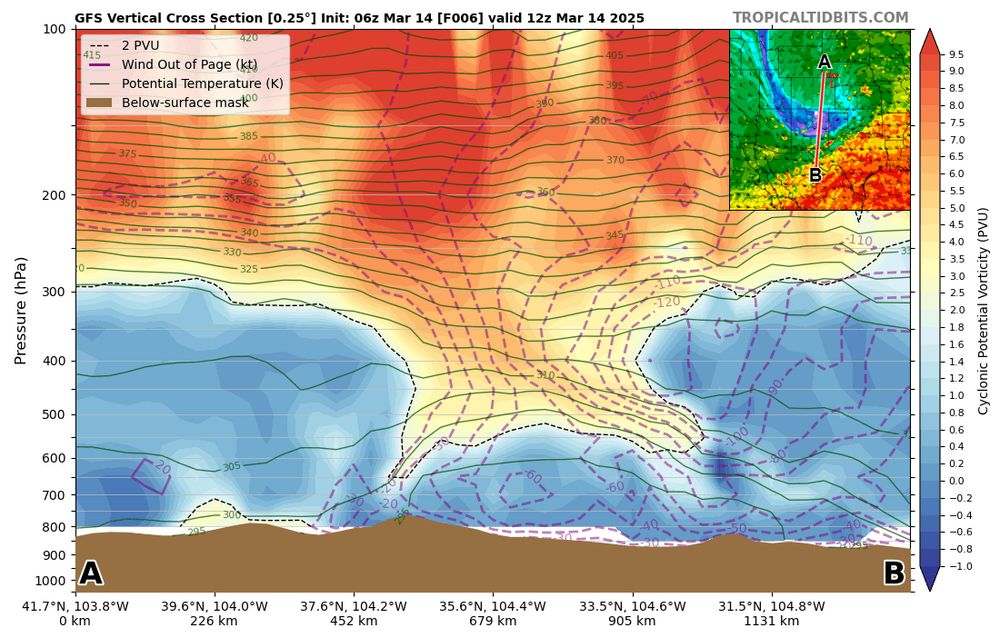
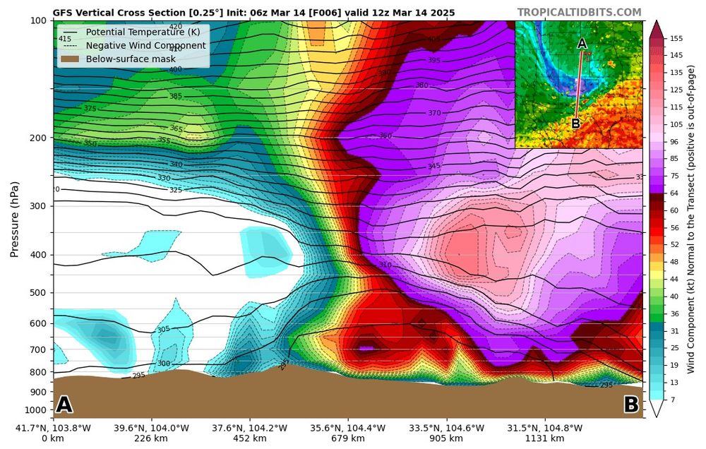
Observed ABQ sounding with a tropopause around 400mb (at 35N) in a tropopause fold! This tropopause fold is interacting with two jet streaks within the subtropical jet (seen on water vapor) while ejecting into the Plains and taking on a severe negative tilt. Just a powder keg of a synoptic setup.
March 14, 2025 at 1:38 PM
Observed ABQ sounding with a tropopause around 400mb (at 35N) in a tropopause fold! This tropopause fold is interacting with two jet streaks within the subtropical jet (seen on water vapor) while ejecting into the Plains and taking on a severe negative tilt. Just a powder keg of a synoptic setup.