


ridens1
@ridens1.bsky.social
Weather nerd, artist, writer, fisher, disc golfer, Christ-follower, husband, dad
Reposted by ridens1

Here's a free Patreon post about this Youngblood #2 variant cover.
December 23, 2025 at 10:16 PM
Here's a free Patreon post about this Youngblood #2 variant cover.
Reposted by ridens1
The mountain wave this morning had enough forcing to it that the inflow had the same characteristic texture as a good convective updraft base
With some cool virga downstream #wywx
With some cool virga downstream #wywx
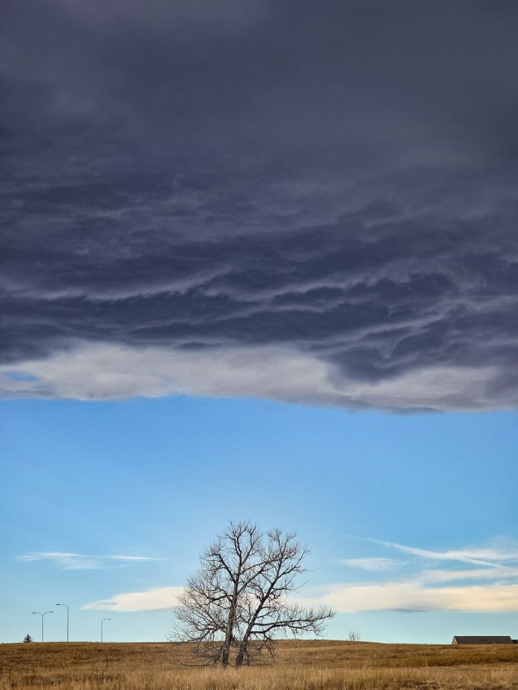

December 15, 2025 at 7:13 PM
The mountain wave this morning had enough forcing to it that the inflow had the same characteristic texture as a good convective updraft base
With some cool virga downstream #wywx
With some cool virga downstream #wywx
Make the DGEX and ETA weather models great again!
December 11, 2025 at 10:06 PM
Make the DGEX and ETA weather models great again!
Reposted by ridens1

You may have seen a "GraphCast-GFS" model on some real-time websites - development on that model at NOAA has now led to the "AI-GFS" model which is scheduled to become operational on December 17th.
Output from the AI-GFS model is now available on PolarWx: polarwx.com/models/?mode...
Output from the AI-GFS model is now available on PolarWx: polarwx.com/models/?mode...

December 11, 2025 at 12:45 AM
You may have seen a "GraphCast-GFS" model on some real-time websites - development on that model at NOAA has now led to the "AI-GFS" model which is scheduled to become operational on December 17th.
Output from the AI-GFS model is now available on PolarWx: polarwx.com/models/?mode...
Output from the AI-GFS model is now available on PolarWx: polarwx.com/models/?mode...
Reposted by ridens1

New evidence suggests weather persistence is increasing in the northern mid– and high latitudes due to climate change.
So far, I’ve been skeptical as the signal seems small compared to natural variability, but maybe it’s time to update my thinking.
www.nature.com/articles/s43...
So far, I’ve been skeptical as the signal seems small compared to natural variability, but maybe it’s time to update my thinking.
www.nature.com/articles/s43...

Enhanced weather persistence due to amplified Arctic warming - Communications Earth & Environment
Weather persistence, in terms of duration of surface-air temperature anomalies across all weather types and seasons in Northern Hemisphere mid-latitudes, has increased in recent decades due to Arctic ...
www.nature.com
December 9, 2025 at 6:38 AM
New evidence suggests weather persistence is increasing in the northern mid– and high latitudes due to climate change.
So far, I’ve been skeptical as the signal seems small compared to natural variability, but maybe it’s time to update my thinking.
www.nature.com/articles/s43...
So far, I’ve been skeptical as the signal seems small compared to natural variability, but maybe it’s time to update my thinking.
www.nature.com/articles/s43...
Are we beginning to see the end of La Nina?

December 4, 2025 at 12:27 PM
Are we beginning to see the end of La Nina?
Reposted by ridens1

Just a friendly reminder that the Polar Vortex is not an Arctic storm, polar hurricane, blizzard or things that comes to visit us. Lobes of its wave system can dip south into the U.S. bringing colder air. I have already seen a car commercial improperly refer to it and a major newspaper headline.

November 30, 2025 at 2:17 PM
Just a friendly reminder that the Polar Vortex is not an Arctic storm, polar hurricane, blizzard or things that comes to visit us. Lobes of its wave system can dip south into the U.S. bringing colder air. I have already seen a car commercial improperly refer to it and a major newspaper headline.
Reposted by ridens1

TAO buoy subsurface animation for this past month
Notice the thermocline is quickly deepening and the subsurface anomalies are beginning to advance eastward over the West-Central Equatorial Pacific.
Notice the thermocline is quickly deepening and the subsurface anomalies are beginning to advance eastward over the West-Central Equatorial Pacific.
November 29, 2025 at 7:43 PM
TAO buoy subsurface animation for this past month
Notice the thermocline is quickly deepening and the subsurface anomalies are beginning to advance eastward over the West-Central Equatorial Pacific.
Notice the thermocline is quickly deepening and the subsurface anomalies are beginning to advance eastward over the West-Central Equatorial Pacific.
Reposted by ridens1
ECMWF ensembles continue confident we'll get at least very close to a Sudden Stratospheric Warming (SSW) by the end of the month, although the surface impacts will depend on the details of the event (and a significant dash of randomness).

November 18, 2025 at 6:59 PM
ECMWF ensembles continue confident we'll get at least very close to a Sudden Stratospheric Warming (SSW) by the end of the month, although the surface impacts will depend on the details of the event (and a significant dash of randomness).
Reposted by ridens1
Quietly while La Niña persists, the tropical upper troposphere is becoming very El Niño-like
A large build-up of westerly momentum (+U) in the tropics is being supplanted by a West Pac MJO orbit & repeated bouts of positive E Asia Mtn Torque (+EAMT) fluxing/squeezing +U equatorward
A large build-up of westerly momentum (+U) in the tropics is being supplanted by a West Pac MJO orbit & repeated bouts of positive E Asia Mtn Torque (+EAMT) fluxing/squeezing +U equatorward


November 11, 2025 at 11:01 PM
Quietly while La Niña persists, the tropical upper troposphere is becoming very El Niño-like
A large build-up of westerly momentum (+U) in the tropics is being supplanted by a West Pac MJO orbit & repeated bouts of positive E Asia Mtn Torque (+EAMT) fluxing/squeezing +U equatorward
A large build-up of westerly momentum (+U) in the tropics is being supplanted by a West Pac MJO orbit & repeated bouts of positive E Asia Mtn Torque (+EAMT) fluxing/squeezing +U equatorward
Reposted by ridens1
It was well forecast for ~10 days, and the spv stratospheric polar vortex has now doubled in strength this past week
EC analysis showing W winds 10hpa 60N increasing from around 35mph to around 70mph
Models have also been forecasting a weakening going forward now..one to watch
EC analysis showing W winds 10hpa 60N increasing from around 35mph to around 70mph
Models have also been forecasting a weakening going forward now..one to watch


November 8, 2025 at 6:01 PM
It was well forecast for ~10 days, and the spv stratospheric polar vortex has now doubled in strength this past week
EC analysis showing W winds 10hpa 60N increasing from around 35mph to around 70mph
Models have also been forecasting a weakening going forward now..one to watch
EC analysis showing W winds 10hpa 60N increasing from around 35mph to around 70mph
Models have also been forecasting a weakening going forward now..one to watch
Reposted by ridens1
Even when you look at November, this year really isn’t doing anything out of the ordinary for a La Niña


November 7, 2025 at 2:16 PM
Even when you look at November, this year really isn’t doing anything out of the ordinary for a La Niña
Reposted by ridens1
La Niña is living on borrowed time.
The extreme -IOD we're currently seeing (right) is about to collapse because the warm water in the Equatorial Indian Ocean will get flushed into the tropical West Pac at depth over the next month in this MJO event's westerly wind burst (left)
The extreme -IOD we're currently seeing (right) is about to collapse because the warm water in the Equatorial Indian Ocean will get flushed into the tropical West Pac at depth over the next month in this MJO event's westerly wind burst (left)


November 5, 2025 at 9:10 PM
La Niña is living on borrowed time.
The extreme -IOD we're currently seeing (right) is about to collapse because the warm water in the Equatorial Indian Ocean will get flushed into the tropical West Pac at depth over the next month in this MJO event's westerly wind burst (left)
The extreme -IOD we're currently seeing (right) is about to collapse because the warm water in the Equatorial Indian Ocean will get flushed into the tropical West Pac at depth over the next month in this MJO event's westerly wind burst (left)
Reposted by ridens1
As per metoffice long range & seasonal forecasts, many weather drivers in favour of some higher pressure/more blocked weather patterns developing in the weeks ahead:
1. Weak La Nina
2. E QBO
3. -IOD
4. Active MJO heading into phase 6/7
5. Potential weaker stratospheric polar vortex
1. Weak La Nina
2. E QBO
3. -IOD
4. Active MJO heading into phase 6/7
5. Potential weaker stratospheric polar vortex


November 6, 2025 at 11:01 PM
As per metoffice long range & seasonal forecasts, many weather drivers in favour of some higher pressure/more blocked weather patterns developing in the weeks ahead:
1. Weak La Nina
2. E QBO
3. -IOD
4. Active MJO heading into phase 6/7
5. Potential weaker stratospheric polar vortex
1. Weak La Nina
2. E QBO
3. -IOD
4. Active MJO heading into phase 6/7
5. Potential weaker stratospheric polar vortex
Reposted by ridens1
As hinted over a week ago, the spv stratospheric polar vortex continues with its spell of strengthening..now observed to be a W'ly 50mph at 10hpa 60N and expected to reach around 70mph in a few days time
Thereafter, also worth watching for a consistently signalled weakening
Thereafter, also worth watching for a consistently signalled weakening


November 5, 2025 at 5:21 PM
As hinted over a week ago, the spv stratospheric polar vortex continues with its spell of strengthening..now observed to be a W'ly 50mph at 10hpa 60N and expected to reach around 70mph in a few days time
Thereafter, also worth watching for a consistently signalled weakening
Thereafter, also worth watching for a consistently signalled weakening
Reposted by ridens1

🔥🔥🔥Canada with their warmest October on record. Departure from 1991-2020 normal is +3.7C.🔥🔥🔥

November 5, 2025 at 2:34 AM
🔥🔥🔥Canada with their warmest October on record. Departure from 1991-2020 normal is +3.7C.🔥🔥🔥
Reposted by ridens1

Reposted by ridens1

Interesting to see so many ECMWF ensemble members producing a major sudden stratospheric warming event, where the 60N zonal wind at 10 hPa reverses, in late Nov or 1st half Dec.
In records back to 1959 I'm aware of only 3 major SSWs within 1st half Dec & none in November.
In records back to 1959 I'm aware of only 3 major SSWs within 1st half Dec & none in November.

November 4, 2025 at 11:31 AM
Interesting to see so many ECMWF ensemble members producing a major sudden stratospheric warming event, where the 60N zonal wind at 10 hPa reverses, in late Nov or 1st half Dec.
In records back to 1959 I'm aware of only 3 major SSWs within 1st half Dec & none in November.
In records back to 1959 I'm aware of only 3 major SSWs within 1st half Dec & none in November.
Reposted by ridens1
This winter seems to be intent on following the cool ENSO/East QBO/solar max paradigm of early winter -AO/-NAO
I replicated Gray et al (2004)'s analysis except used SLPa from 20CR & isolated -ENSO (left), which is close to the latest Euro weekly forecast (right) journals.ametsoc.org/view/journal...
I replicated Gray et al (2004)'s analysis except used SLPa from 20CR & isolated -ENSO (left), which is close to the latest Euro weekly forecast (right) journals.ametsoc.org/view/journal...


November 3, 2025 at 10:04 PM
This winter seems to be intent on following the cool ENSO/East QBO/solar max paradigm of early winter -AO/-NAO
I replicated Gray et al (2004)'s analysis except used SLPa from 20CR & isolated -ENSO (left), which is close to the latest Euro weekly forecast (right) journals.ametsoc.org/view/journal...
I replicated Gray et al (2004)'s analysis except used SLPa from 20CR & isolated -ENSO (left), which is close to the latest Euro weekly forecast (right) journals.ametsoc.org/view/journal...
Reposted by ridens1

I'm told THE SWORD DEFIANT is on discount in the US and Canada, in the you feel like starting a new trilogy with magic talking swords, aged heroes, and bringing down kings...
www.amazon.com/Sword-Defian...
www.amazon.com/Sword-Defian...

November 3, 2025 at 3:46 PM
I'm told THE SWORD DEFIANT is on discount in the US and Canada, in the you feel like starting a new trilogy with magic talking swords, aged heroes, and bringing down kings...
www.amazon.com/Sword-Defian...
www.amazon.com/Sword-Defian...
Reposted by ridens1
Both of these lead to the development of this pattern, which often becomes more strong/persistent late winter as it interacts w/ the stratospheric polar vortex via wave reflection.
Here's what this -EPO/+TNH or "ABNA" pattern looks like in winter (annotated over their fig 1)
Here's what this -EPO/+TNH or "ABNA" pattern looks like in winter (annotated over their fig 1)

November 1, 2025 at 2:49 AM
Both of these lead to the development of this pattern, which often becomes more strong/persistent late winter as it interacts w/ the stratospheric polar vortex via wave reflection.
Here's what this -EPO/+TNH or "ABNA" pattern looks like in winter (annotated over their fig 1)
Here's what this -EPO/+TNH or "ABNA" pattern looks like in winter (annotated over their fig 1)
Reposted by ridens1
Worth mentioning, this year has the 2 main precursors to a -EPO/+TNH ("polar vortex" pattern) dominated winter in place atm as identified by Zhong & Wu (2023).
Namely, a warmer-than-normal Maritime Continent & West Pac as well as a Eurasian Snow Cover Dipole.
journals.ametsoc.org/view/journal...
Namely, a warmer-than-normal Maritime Continent & West Pac as well as a Eurasian Snow Cover Dipole.
journals.ametsoc.org/view/journal...


November 1, 2025 at 2:48 AM
Worth mentioning, this year has the 2 main precursors to a -EPO/+TNH ("polar vortex" pattern) dominated winter in place atm as identified by Zhong & Wu (2023).
Namely, a warmer-than-normal Maritime Continent & West Pac as well as a Eurasian Snow Cover Dipole.
journals.ametsoc.org/view/journal...
Namely, a warmer-than-normal Maritime Continent & West Pac as well as a Eurasian Snow Cover Dipole.
journals.ametsoc.org/view/journal...
Reposted by ridens1
Extending the analysis back to 1900 in 20CR (& using the Bronnimann et al (2007) QBO reconstruction) reveals a similar pattern for IPWP strength during eQBO/-ENSO winters:

November 1, 2025 at 2:07 AM
Extending the analysis back to 1900 in 20CR (& using the Bronnimann et al (2007) QBO reconstruction) reveals a similar pattern for IPWP strength during eQBO/-ENSO winters:
Reposted by ridens1

The Advanced Dvorak Technique (ADT) satellite-derived intensity estimate peaked at 185 knots for #Melissa -- which, according to the developer at CIMSS, is the highest value to date for any tropical cyclone.

October 28, 2025 at 10:41 PM
The Advanced Dvorak Technique (ADT) satellite-derived intensity estimate peaked at 185 knots for #Melissa -- which, according to the developer at CIMSS, is the highest value to date for any tropical cyclone.
Reposted by ridens1
Holy mackerel, what a dropsonde….
This explicitly supports Melissa being a 145-150 knot hurricane 😳
This explicitly supports Melissa being a 145-150 knot hurricane 😳

October 27, 2025 at 1:09 PM
Holy mackerel, what a dropsonde….
This explicitly supports Melissa being a 145-150 knot hurricane 😳
This explicitly supports Melissa being a 145-150 knot hurricane 😳