


Kurtis M.
@stormorknot.bsky.social
Meteorologist | Catastrophe Modeler | Skywarn Spotter | Data wrangler | Inquisitive | Views are my own
He/him
🏠Boston
He/him
🏠Boston
Pinned
Kurtis M.
@stormorknot.bsky.social
· Nov 12
Hello world!
I’m a meteorologist who works in catastrophe modeling and lives in Boston. Hopefully I can find other people who want to chat about the weather or data science. R is my primary programming language.
I’m a meteorologist who works in catastrophe modeling and lives in Boston. Hopefully I can find other people who want to chat about the weather or data science. R is my primary programming language.
Reposted by Kurtis M.

Most of the scientists at the nonprofit that I cofounded, including my two cofounders, came from NCAR. It’s hard to overstate the importance of this place for climate science.

Exclusive: The Trump administration is moving to dismantle the National Center for Atmospheric Research in Colorado, according to a senior White House official, taking aim at one of the world's leading climate research labs.

Trump moves to dismantle major US climate research center in Colorado
The Trump administration is breaking up the National Center for Atmospheric Research, taking aim at one of the world's leading climate research labs.
bit.ly
December 17, 2025 at 5:16 AM
Most of the scientists at the nonprofit that I cofounded, including my two cofounders, came from NCAR. It’s hard to overstate the importance of this place for climate science.
Reposted by Kurtis M.

Homes that had cleared vegetation within five feet of the walls were less likely to burn in the Eaton and Palisades fire, new investigation funded by the insurance industry finds: www.latimes.com/environment/... via @nohaggerty.bsky.social

Early adopters of 'zone zero' fared better in L.A. County fires, insurance-backed investigation finds
A new study found that in the Eaton and Palisades fires, homes that had already adopted proposed regulations on creating vegetation-free buffers were less likely to burn.
www.latimes.com
December 11, 2025 at 10:48 PM
Homes that had cleared vegetation within five feet of the walls were less likely to burn in the Eaton and Palisades fire, new investigation funded by the insurance industry finds: www.latimes.com/environment/... via @nohaggerty.bsky.social

Crazy footage.
If you're in Washington state, please be careful and follow local guidance and any emergency instructions.
Nature is metal 🔥
If you're in Washington state, please be careful and follow local guidance and any emergency instructions.
Nature is metal 🔥
December 12, 2025 at 8:16 PM
Reposted by Kurtis M.

Weather tracker: Australia bushfires could be most dangerous since ‘black summer’

Weather tracker: Australia bushfires could be most dangerous since ‘black summer’
Fires are burning across NSW, with Tasmania also facing an emergency, while in US, Washington state braces for floods
www.theguardian.com
December 12, 2025 at 10:02 AM
Weather tracker: Australia bushfires could be most dangerous since ‘black summer’
Reposted by Kurtis M.

Hi hello the Venezuela stuff is entirely about oil, both in Venezuela and in Guyana (where Venezuela is laying claim to the oil in what is now Exxon’s largest oilfield, which Chevron has also bought into). It is the bidding of US oil majors and it’s not remotely subtle.
December 11, 2025 at 9:39 AM
Hi hello the Venezuela stuff is entirely about oil, both in Venezuela and in Guyana (where Venezuela is laying claim to the oil in what is now Exxon’s largest oilfield, which Chevron has also bought into). It is the bidding of US oil majors and it’s not remotely subtle.
Reposted by Kurtis M.

A powerful atmospheric river has drenched Washington state with nearly 5 trillion gallons of rain over the past week. The deluge is linked to warm water and air, along with unusual weather conditions tracing back to tropical cyclone flooding in Indonesia.

Blend of unusual weather conditions brings trillions of gallons in persistent rain to the Northwest
A powerful atmospheric river has drenched Washington state with nearly 5 trillion gallons of rain over the past week.
bit.ly
December 11, 2025 at 10:30 AM
A powerful atmospheric river has drenched Washington state with nearly 5 trillion gallons of rain over the past week. The deluge is linked to warm water and air, along with unusual weather conditions tracing back to tropical cyclone flooding in Indonesia.
Reposted by Kurtis M.

There was a time when access to detailed exposure data was a major limitation for looking at global climate risk. But there has been an explosion of useful building stock products in last few years, and a real opportunity for those in the climate community who can figure out how to put to good use.

This is pretty cool.
I wonder how this might be used to do better climate work — e.g., for addressing emissions linked to buildings, and mapping infrastructure for climate adaptation work?
interestingengineering.com/innovation/f...
I wonder how this might be used to do better climate work — e.g., for addressing emissions linked to buildings, and mapping infrastructure for climate adaptation work?
interestingengineering.com/innovation/f...

World's buildings mapped for the first time in high-resolution 3D map
Technical University of Munich researchers have just unveiled GlobalBuildingAtlas, a new 3D map that captures every building on the planet.
interestingengineering.com
December 9, 2025 at 12:01 AM
There was a time when access to detailed exposure data was a major limitation for looking at global climate risk. But there has been an explosion of useful building stock products in last few years, and a real opportunity for those in the climate community who can figure out how to put to good use.

BREAKING: A tsunami as high as 10 feet could hit Japan's northeastern coast after an earthquake with an estimated magnitude of 7.6 occurred offshore, the Japan Meteorological Agency said reut.rs/44iNwL0
December 8, 2025 at 3:15 PM
Here is a good episode on catastrophe bonds, catastrophe models, and #insurance. Plus an interview with Karen Clark.
#wxsky #climaterisk #wxrisk #catrisk
#wxsky #climaterisk #wxrisk #catrisk

A nice podcast on the catastrophe bond market. It’s been a huge year for the market and I am very much looking forward to a hibernation over the Holidays #climaterisk
podcasts.apple.com/us/podcast/p...
podcasts.apple.com/us/podcast/p...

How hurricanes became a hot investment
Podcast Episode · Planet Money · 12/05/2025 · 31m
podcasts.apple.com
December 6, 2025 at 7:21 PM
Here is a good episode on catastrophe bonds, catastrophe models, and #insurance. Plus an interview with Karen Clark.
#wxsky #climaterisk #wxrisk #catrisk
#wxsky #climaterisk #wxrisk #catrisk
Reposted by Kurtis M.

Floods in #Indonesia.
The animation shows the impact of severe inundation in the northeastern part of #Sumatra, comparing #Copernicus #Sentinel2 images from Aug. and Dec. 1, 2025.
Relentless monsoon rains and tropical cyclones have devastated parts of Asia. #ClimateEmergency
The animation shows the impact of severe inundation in the northeastern part of #Sumatra, comparing #Copernicus #Sentinel2 images from Aug. and Dec. 1, 2025.
Relentless monsoon rains and tropical cyclones have devastated parts of Asia. #ClimateEmergency
December 3, 2025 at 2:17 PM
Floods in #Indonesia.
The animation shows the impact of severe inundation in the northeastern part of #Sumatra, comparing #Copernicus #Sentinel2 images from Aug. and Dec. 1, 2025.
Relentless monsoon rains and tropical cyclones have devastated parts of Asia. #ClimateEmergency
The animation shows the impact of severe inundation in the northeastern part of #Sumatra, comparing #Copernicus #Sentinel2 images from Aug. and Dec. 1, 2025.
Relentless monsoon rains and tropical cyclones have devastated parts of Asia. #ClimateEmergency
Reposted by Kurtis M.
Drag queen Pattie Gonia completes 100-mile trek raising $1m to make outdoors more ‘equitable’

Drag queen Pattie Gonia completes 100-mile trek raising $1m to make outdoors more ‘equitable’
Drag queen, environmentalist, diversity and inclusion advocate and social media star arrives in San Francisco
www.theguardian.com
December 6, 2025 at 3:01 PM
Drag queen Pattie Gonia completes 100-mile trek raising $1m to make outdoors more ‘equitable’

This week marked the end of 2025 Atlantic hurricane season. It was comprised of...
13 named storms
5 hurricanes
4 major hurricane
13 named storms
5 hurricanes
4 major hurricane

December 5, 2025 at 11:43 PM
Reposted by Kurtis M.

Let's check in on Mt. Washington tonight...

December 5, 2025 at 2:50 AM
Let's check in on Mt. Washington tonight...

Here's 10 different views on the 2025 hurricane season from a report we did at Oak Global.
1) ACE was pretty much bang-on average, but the number of hours of Cat 4s was almost double the usual: these contributed nearly all the ACE as we had so few weak Cat 1-2s this year.
1) ACE was pretty much bang-on average, but the number of hours of Cat 4s was almost double the usual: these contributed nearly all the ACE as we had so few weak Cat 1-2s this year.

December 5, 2025 at 3:32 AM
Reposted by Kurtis M.

Today marks the end of the 2025 Atlantic hurricane season. A great example where the perception in the United States is that it was a "quiet" season, but the reality isn't so simple.
The US got lucky; other places (Jamaica), did not.
Where storms track and how intense they are matters most.
(1/2)
The US got lucky; other places (Jamaica), did not.
Where storms track and how intense they are matters most.
(1/2)

November 30, 2025 at 7:10 PM
Today marks the end of the 2025 Atlantic hurricane season. A great example where the perception in the United States is that it was a "quiet" season, but the reality isn't so simple.
The US got lucky; other places (Jamaica), did not.
Where storms track and how intense they are matters most.
(1/2)
The US got lucky; other places (Jamaica), did not.
Where storms track and how intense they are matters most.
(1/2)
Reposted by Kurtis M.

Meteorologists are surprised that the weather model that did the best job forecasting hurricanes this year was a new one, introduced by Google. AI may be the beginning of a new era of forecasting. n.pr/49MFa1M

As the 2025 Atlantic hurricane season ends, the future of forecasting is AI
Meteorologists are surprised that the weather model that did the best job forecasting hurricanes this year was a new one, introduced by Google. AI may be the beginning of a new era of forecasting.
n.pr
November 30, 2025 at 3:26 AM
Meteorologists are surprised that the weather model that did the best job forecasting hurricanes this year was a new one, introduced by Google. AI may be the beginning of a new era of forecasting. n.pr/49MFa1M
Renewable energy is dominating energy demands. Hopefully, this trend continues and expands.
#renewables #fossilfuelfree
#renewables #fossilfuelfree
Spread the word: Through Q3 2025, Solar & Wind have met *ALL* global demand growth to date. Get the details here. #FossilFuelsAreStrandedAssets 🧪🔌💡☀️💨💧🔋 🧵 ember-energy.org/latest-insig...

Q3 Global Power Report: No fossil fuel growth expected in 2025 | Ember
Solar and wind power grew fast enough to keep up with rising electricity demand in the first three quarters of 2025, as fossil fuel growth should be stagnated. Ember forecasts no growth for fossil fue...
ember-energy.org
November 30, 2025 at 10:58 AM
Renewable energy is dominating energy demands. Hopefully, this trend continues and expands.
#renewables #fossilfuelfree
#renewables #fossilfuelfree
Reposted by Kurtis M.

Revealed: Europe’s water reserves drying up due to climate breakdown www.theguardian.com/environment/...

Revealed: Europe’s water reserves drying up due to climate breakdown
Exclusive: UCL scientists find large swathes of southern Europe are drying up, with ‘far-reaching’ implications
www.theguardian.com
November 30, 2025 at 12:28 AM
Revealed: Europe’s water reserves drying up due to climate breakdown www.theguardian.com/environment/...
Reposted by Kurtis M.

SETTING: SOMETIME IN THE FUTURE: We were hurtling towards climate chaos which ended up really hurting the economy. More info here: doi.org/10.1093/bios...

November 27, 2025 at 10:02 PM
SETTING: SOMETIME IN THE FUTURE: We were hurtling towards climate chaos which ended up really hurting the economy. More info here: doi.org/10.1093/bios...
Reposted by Kurtis M.

Deloitte also fucked up the same way in Australia www.theguardian.com/australia-ne...
November 23, 2025 at 8:59 AM
Deloitte also fucked up the same way in Australia www.theguardian.com/australia-ne...
Reposted by Kurtis M.

Countries that have abortion access, DEI policies or protection for LGBTQ+ people will be considered “human rights violators“ by the Trump regime
We’re in the upside down.
www.forbes.com/sites/maryro...
We’re in the upside down.
www.forbes.com/sites/maryro...

Abortion And DEI Policies Now Considered Violations Of Human Rights, U.S. Says
The Trump administration has overhauled how the State Department conducts its annual Human Rights Report.
www.forbes.com
November 25, 2025 at 9:48 PM
Countries that have abortion access, DEI policies or protection for LGBTQ+ people will be considered “human rights violators“ by the Trump regime
We’re in the upside down.
www.forbes.com/sites/maryro...
We’re in the upside down.
www.forbes.com/sites/maryro...
Reposted by Kurtis M.

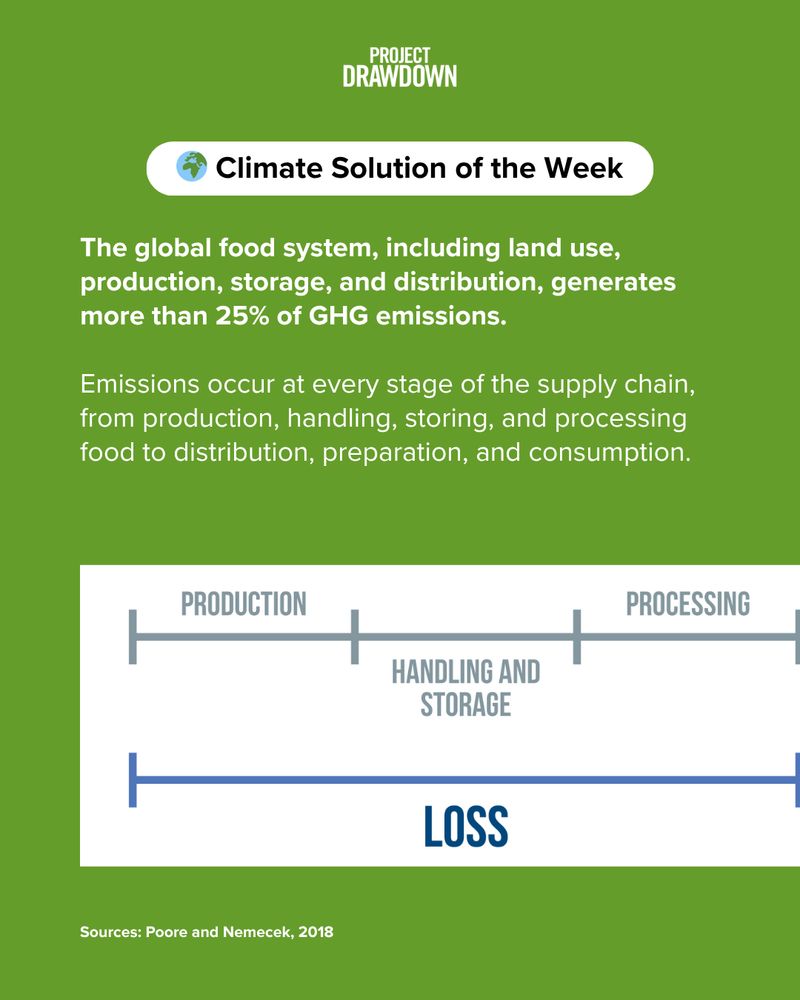
The holiday season is here — a time for good food and good company! 🍽️ It’s also a reminder that reducing food loss and waste is one of the most effective climate solutions available today.
Learn more about action you can take in the Take Action section of each solution! ⬇️
🔗 https://bit.ly/4ia789A
Learn more about action you can take in the Take Action section of each solution! ⬇️
🔗 https://bit.ly/4ia789A


November 24, 2025 at 2:50 PM
The holiday season is here — a time for good food and good company! 🍽️ It’s also a reminder that reducing food loss and waste is one of the most effective climate solutions available today.
Learn more about action you can take in the Take Action section of each solution! ⬇️
🔗 https://bit.ly/4ia789A
Learn more about action you can take in the Take Action section of each solution! ⬇️
🔗 https://bit.ly/4ia789A


Reposted by Kurtis M.

New England winters can get wicked cold — so these five states are partnering to keep homes toasty with heat pumps.

New England kicks off $450M plan to supercharge heat pump adoption
The program aims to use federal funds awarded under the Biden administration to deploy more than 500,000 heat pumps in the chilly region over the next few…
www.canarymedia.com
November 24, 2025 at 12:43 PM
New England winters can get wicked cold — so these five states are partnering to keep homes toasty with heat pumps.
Reposted by Kurtis M.

La Niña, the Madden-Julian Oscillation (MJO), and the potential for a rare November Sudden Stratospheric Warming event (you're likely to have heard of this referred to as the "polar vortex") may combine to drive winter-like conditions across much of the U.S. late November into early December.

November 22, 2025 at 2:00 PM
La Niña, the Madden-Julian Oscillation (MJO), and the potential for a rare November Sudden Stratospheric Warming event (you're likely to have heard of this referred to as the "polar vortex") may combine to drive winter-like conditions across much of the U.S. late November into early December.