a.s.
@wxandbiscuits.bsky.social
1.4K followers 1K following 550 posts
fire/tropical meteorologist. dogs, native plants and good food. georgia now but midwest is home. he/him/🏳️‍🌈. opinions my own.
Posts Media Videos Starter Packs
Reposted by a.s.
j2huss.bsky.social
One day in the lab, we accidentally discovered that the spines of a cactus 🌵 straighten when exposed to fog. I was intrigued and so were my collaborators. How does this work and what can be gained from it? Here are some of the answers in our new preprint:
doi.org/10.1101/2025...
Reposted by a.s.
michaelwara.bsky.social
A hill I will die on is that the Palisades Fire was not “caused” by the person who lit the Lachman Fire. It was caused by systematic failure to prepare landscapes and communities to receive fires that will inevitably occur in a fire prone region in which 25 million people live.
Reposted by a.s.
bmcnoldy.bsky.social
A trio of cyclonic eddies in the Gulf of Mexico are creating record-high Ocean Heat Content values for the date. Absolutely something of importance during this part of hurricane season.
@miamirosenstiel.bsky.social
Reposted by a.s.
rschumacher.cloud
Highly unusual situation approaching western Colorado with the moisture from Hurricane Priscilla. Grand Junction has never had precipitable water over an inch (25mm) so late in the year, but looks like it will be near that level on both Fri & Sat. Six standard deviations above average! #cowx 1/2
Global Ensemble Forecast System mean precipitable water and 700-mb winds valid on Saturday morning, 11 October 2025. A big plume of moisture will be transported into the southwest US ahead of decaying Hurricane Priscilla. From https://schumacher.atmos.colostate.edu/weather/ens.php Standardized anomaly of precipitable water from the ECWMF ensemble mean on Saturday morning, 11 October 2025. It shows a broad swath of  greater than +3 standard deviations in the western US. From https://schumacher.atmos.colostate.edu/weather/ecmwf.php Ensemble forecast plume showing precipitable water at Grand Junction, Colorado in the members of the ECWMF ensemble. Values are predicted to be around 25-30 mm with high confidence on Friday 10 October through Saturday 11 October, far above the 90th percentile for the date.  From https://schumacher.atmos.colostate.edu/weather/ecmwf.php
Reposted by a.s.
michaelrlowry.bsky.social
Jerry's a top 1% in terms of its fast movement through the deep tropics. Its speed is knocking its circulation off kilter but it should organize as it slows and turns near the islands. Also, as Jerry would say, what's the deal with the weekend nor'easter?
Jerry Forms but Slow to Strengthen, Tropical Storm Watches Issued for the Northern Leeward Islands
Jerry forecast to pass near the northern Leeward Islands as a hurricane tomorrow and Friday but turn well east of the U.S.
michaelrlowry.substack.com
Reposted by a.s.
drjeffmasters.bsky.social
Drought is climate change's biggest threat: If this winter is as dry as last winter, and no major reductions in use occur, Lake Powell by 2027 would have no storage left and “would have to be operated as a ‘run of river' facility” in which only the inflow from the river could be released downstream.
‘No One Comes Out of This Unscathed’: Experts Warn That Colorado River Use Needs Cutting Immediately - Inside Climate News
A new report finds that Lakes Mead and Powell, the nation’s largest reservoirs, could store just 9 percent of their combined capacity by the end of next summer.
insideclimatenews.org
wxandbiscuits.bsky.social
CPC keeps the CAG TC risk going into late October.
CPC tropical cyclone potential next week (top) and Oct 22-28 (bottom). At least a 40% chance for development both weeks with the Central American after. Another Cabo Verde African wave storm could form behind Jerry.
Reposted by a.s.
pppapin.bsky.social
Its verification time. As of 15z Today Oct 7th, Tropical Storm #Jerry has formed with 40 kt winds.

Pretty clear at this point the #ECMWF has struggled with this genesis case, possibly due to the same amped up gravity wave issues that have plagued the model in the tropics for some time.
Reposted by a.s.
nhcbot.bsky.social
Tropical Storm #Jerry Advisory 1: Tropical Storm Jerry Forms Over the Tropical Central Atlantic. The Tenth Named Storm of the Season. http://hurricanes.gov https://x.com/NHC_Atlantic/status/1975570820433846750
Reposted by a.s.
burgwx.bsky.social
Now that the data is backfilled, the deterministic AIFS did quite well with Typhoon Halong - it was the only model I track on my site that consistently depicted a quick recurve south of Japan:
Reposted by a.s.
drkimwood.bsky.social
Though warmth in the Caribbean Sea is not at 2023 or 2024 levels as of yesterday (5 October 2025), it's noticeably beyond what's been observed via area-wide sea surface temperatures (SSTs) in other years since 1982.
Line plots of area-averaged sea surface temperature in the Caribbean Sea as of October 5, 2025. Black shows the 1991-2020 average, red shows 2023, orange shows 2024, and blue shows 2025 (so far). An inset map depicts October 5th's map of anomalies, where the dashed box represents the averaging region used to make the line plot values. These are computed from NOAA's OISST dataset using Python.
Reposted by a.s.
nhcbot.bsky.social
8am EDT Oct 5th -- NHC is monitoring an area of low pressure associated with a tropical wave (#AL95) which now has a high chance (70% 🔴) of formation over the next week. It is forecast to approach the Leeward Islands by late this week. Late... https://x.com/NHC_Atlantic/status/1974805335572693115
wxandbiscuits.bsky.social
Now up to 3500 acres and 35% contained. #TXwx #TuleFire
wxandbiscuits.bsky.social
The Tule Fire in Briscoe County, TX, is burning in an area with at least 130% of normal fuel loading. Not a good sign for the Southern Plains the next 6 months given that fires over 1000 acres are rare this time of year.
The Tule Fire is estimated by the Texas A&M Forest Service to be ~1500 acres and 0% contained as of 3:45 PM CT Saturday. It may be burning into the tricky terrain of Tule Canyon, where firefighting is much more difficult than the flatter Caprock/ag areas. Grass-cast shows dark blue areas have at least 130% of normal grass loading from an abnormally wet growing season. Large parts of TX and OK are reported to have well above average to exceptional grass loading that will likely lead to outbreaks of large wildfires this winter into next spring. Texas A&M Forest Service incident viewer showing the Tule Fire south-southeast of Amarillo. Early estimate are 1500 acres with 0% containment.
wxandbiscuits.bsky.social
The climatology graph/map and other goodies are from: repository.library.noaa.gov/view/noaa/48...
wxandbiscuits.bsky.social
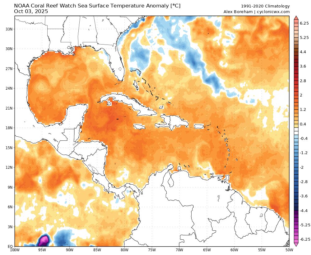
That near-record warm water could easily support intense hurricanes mid- to late month if other conditions align, but it remains to be seen if we’ll get any going outside of the subtropical Atlantic this year. GEFS mean shows the expected CAG well Oct. 12-15.
wxandbiscuits.bsky.social
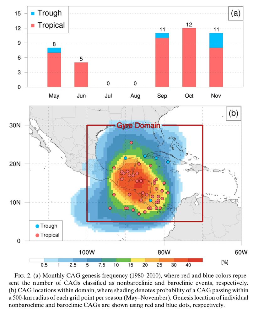
October is peak Central American Gyre (CAG) season, per the climatology from @pppapin.bsky.social et al (2017). Medium range ensembles are locking into the favorable RMM phases (8,1,2), and the untouched western Atlantic continues its 3-year stretch of absurd warmth.
Figure 2 from Papin et al in 2017, showing climatology of Central American Gyre frequency, which occurs in May-June and again from Sep-Nov, with a peak in October. Bottom map shows genesis locations around Central America. RMM plot from NOAA’s CPC showing the GEFS bias-corrected forecast in the phases supportive of CAG development October ~11-18. Cyclonicwx’s sea-surface temperature anomaly map across the western Atlantic. Darker orange and red areas are much warmer than normal, while blue shades off the East Coast are associated with cool upwelling behind Hurricanes Imelda and Humberto. Dr. Brian McNoldy’s climatology of Caribbean ocean heat content shows early October 2025 values (red) just under the historic maximum set the last two Octobers, well above the “normal” conditions in blue.
Reposted by a.s.
skydrama.bsky.social
CORN-ADO CHASING! It was another hot, sunny day with record heat in the Midwest, ripe for dust devils. During the harvest season when cornbelt dust devils fill with corn stalks, I call them corn-adoes! Got my drone into a few of them today.
Reposted by a.s.
webberweather.bsky.social
I wonder where the Rossby Wave Train is
wxandbiscuits.bsky.social
Thanks! I will definitely use it sparingly but also want to try it on my raised beds that squirrels love to fuck up.
wxandbiscuits.bsky.social
I haven’t been able to stop thinking about this powder since I saw your post and just ordered some. 😬
wxandbiscuits.bsky.social
Nice! I don’t really need to look up recipes but like to, to get me going. Going with a white flour and cornmeal mix, and heavy on the creole.
wxandbiscuits.bsky.social
lmao why is this bland abomination the first search result for fried okra?
Bland recipe for fried okra that somehow doesn’t include spice, buttermilk or cornmeal.
Reposted by a.s.
science.org
Anticipating steep cuts to its budget, the National Center for Atmospheric Research, one of the world’s leading climate research centers, has laid off 29 employees and decided not to fill 21 vacant positions. https://scim.ag/46yaM9g
Renowned U.S. climate center trims staff ahead of expected budget cuts
NSF-funded National Center for Atmospheric Research is already shuttered during shutdown
scim.ag