


CJC <3 🇺🇦🌾🚜🌾🇺🇦
@castyman22205.bsky.social
20 year old guy from NJ. Earth sci major at local community college,geosci enthusiast. Reposts/posts stuff related to meteorology,climate science,oceanography,geology,planetary/space science. Atheist. Bi. My philosophical/political views are MINE alone.
Pinned
Thread 🧵 of important science news as it relates to Donald Trump
Below is a 🧵 of recent (since mid-late July) science news as it relates to what Trump is doing to federal science and related topics. This is meant to keep track of his dismantling and also so I myself don’t miss anything. Also my apologies for any repetitiveness.
Reposted by CJC <3 🇺🇦🌾🚜🌾🇺🇦
The Allende meteorite is a 4.5-billion-year-old time capsule. How do we read this ancient history? Join Museum Curator Denton Ebel as he reveals the key: chemical thermodynamics. It’s the same science that explains why it takes longer to boil pasta on a mountaintop than at sea level. Watch.👇

This Space Rock is 4.5 Billion Years Old. Here's Its Secret...
YouTube video by American Museum of Natural History
youtu.be
November 26, 2025 at 3:15 PM
The Allende meteorite is a 4.5-billion-year-old time capsule. How do we read this ancient history? Join Museum Curator Denton Ebel as he reveals the key: chemical thermodynamics. It’s the same science that explains why it takes longer to boil pasta on a mountaintop than at sea level. Watch.👇
Reposted by CJC <3 🇺🇦🌾🚜🌾🇺🇦

⚒️ Article: Extreme daily precipitation events over land could increase by 41% by 2100 with an increase in mesoscale moisture convergence
www.nature.com/articles/s41...
www.nature.com/articles/s41...

Future extreme precipitation amplified by intensified mesoscale moisture convergence - Nature Geoscience
Extreme daily precipitation events over land could increase by about 41% by 2100 under a high-emissions scenario with an increase in mesoscale moisture convergence, according to an ensemble of climate...
www.nature.com
November 18, 2025 at 4:30 PM
⚒️ Article: Extreme daily precipitation events over land could increase by 41% by 2100 with an increase in mesoscale moisture convergence
www.nature.com/articles/s41...
www.nature.com/articles/s41...
Reposted by CJC <3 🇺🇦🌾🚜🌾🇺🇦

🌊🔵 Introducing Blue Spots! These are places that can accelerate marine conservation by concentrating efforts in areas where existing non-extractive economies—especially diving and wildlife tourism—already support biodiversity protection. Dive in to learn more. ⬇️ 💙🐠

Cornerstones of Marine Protection Might Actually be “Blue Spots”
A marine protection method described this week proposes spreading marine protection from areas where wildlife tourism already discourages activities that damage or degrade ecosystems, like fishing or ...
scripps.ucsd.edu
November 26, 2025 at 8:46 PM
🌊🔵 Introducing Blue Spots! These are places that can accelerate marine conservation by concentrating efforts in areas where existing non-extractive economies—especially diving and wildlife tourism—already support biodiversity protection. Dive in to learn more. ⬇️ 💙🐠
Reposted by CJC <3 🇺🇦🌾🚜🌾🇺🇦

Heavy lake effect snow and gusty winds, with local blizzard conditions, will continue into Thanksgiving Day across the Great Lakes. Another winter storm looks to develop over the northern and central Rockies Friday and track across the central Plains through the Midwest and Great Lakes this weekend.
November 27, 2025 at 1:46 AM
Heavy lake effect snow and gusty winds, with local blizzard conditions, will continue into Thanksgiving Day across the Great Lakes. Another winter storm looks to develop over the northern and central Rockies Friday and track across the central Plains through the Midwest and Great Lakes this weekend.
Reposted by CJC <3 🇺🇦🌾🚜🌾🇺🇦

In a new #SRL paper, scientists use GNSS data to model the orientation of the fault that ruptured during Taiwan’s 2024 Hualien earthquake. ⚒️
pubs.geoscienceworld.org/ssa/srl/arti...
pubs.geoscienceworld.org/ssa/srl/arti...

November 27, 2025 at 2:00 AM
In a new #SRL paper, scientists use GNSS data to model the orientation of the fault that ruptured during Taiwan’s 2024 Hualien earthquake. ⚒️
pubs.geoscienceworld.org/ssa/srl/arti...
pubs.geoscienceworld.org/ssa/srl/arti...
Reposted by CJC <3 🇺🇦🌾🚜🌾🇺🇦

Never ending record heat in AUSTRALIA
Another scorching hot night in Queensland and New South Wales with new records of November highest Minimums:
26.0 Rockhampton
23.6 Lord Howe Island
Another scorching hot night in Queensland and New South Wales with new records of November highest Minimums:
26.0 Rockhampton
23.6 Lord Howe Island

November 27, 2025 at 2:21 AM
Never ending record heat in AUSTRALIA
Another scorching hot night in Queensland and New South Wales with new records of November highest Minimums:
26.0 Rockhampton
23.6 Lord Howe Island
Another scorching hot night in Queensland and New South Wales with new records of November highest Minimums:
26.0 Rockhampton
23.6 Lord Howe Island
Reposted by CJC <3 🇺🇦🌾🚜🌾🇺🇦

Mapping of the main quarry on Easter Island where giant statues were carved has uncovered evidence that the monuments may not have been created under the direction of a single chief

Easter Island statues may have been built by small independent groups
Mapping of the main quarry on Easter Island where giant statues were carved has uncovered evidence that the monuments may not have been created under the direction of a single chief
www.newscientist.com
November 26, 2025 at 10:56 PM
Mapping of the main quarry on Easter Island where giant statues were carved has uncovered evidence that the monuments may not have been created under the direction of a single chief
Reposted by CJC <3 🇺🇦🌾🚜🌾🇺🇦

Reposted by CJC <3 🇺🇦🌾🚜🌾🇺🇦
Great map by @aquilaflower.bsky.social: "summer climates across North America. I averaged the 1991-2020 climate normals for mean summer temperature and total summer precipitation within 50,000 square kilometer hexagons using data from ClimateNA. "

November 27, 2025 at 12:56 AM
Great map by @aquilaflower.bsky.social: "summer climates across North America. I averaged the 1991-2020 climate normals for mean summer temperature and total summer precipitation within 50,000 square kilometer hexagons using data from ClimateNA. "


Reposted by CJC <3 🇺🇦🌾🚜🌾🇺🇦

Happy Thanksgiving Eve! Here's a timelapse from Garbage Eve.
Derby experiences so many beautiful auroras!
Derby experiences so many beautiful auroras!
November 27, 2025 at 12:55 AM
Happy Thanksgiving Eve! Here's a timelapse from Garbage Eve.
Derby experiences so many beautiful auroras!
Derby experiences so many beautiful auroras!

Reposted by CJC <3 🇺🇦🌾🚜🌾🇺🇦

OKX issues Dense Fog Advisory for Northeast Suffolk, Northwest Suffolk, Southeast Suffolk, Southwest Suffolk [NY] till Nov 26, 10:00 PM EST Link

November 27, 2025 at 12:49 AM
OKX issues Dense Fog Advisory for Northeast Suffolk, Northwest Suffolk, Southeast Suffolk, Southwest Suffolk [NY] till Nov 26, 10:00 PM EST Link
Reposted by CJC <3 🇺🇦🌾🚜🌾🇺🇦
The aurora got bright last night! I only took about 10,000 photos of it last night. Should I post them 1 at a time?!

November 26, 2025 at 3:11 AM
The aurora got bright last night! I only took about 10,000 photos of it last night. Should I post them 1 at a time?!
Reposted by CJC <3 🇺🇦🌾🚜🌾🇺🇦
The Trumpetfish is such a ridiculous looking creature, they always make me smile. They are masters of color change as well, shading from brown, reddish, orange, and bright yellow. They often drift head-down like this, especially when hanging out in clumps of soft coral. 🦑 #scuba #diving #oceans

November 26, 2025 at 7:28 PM
Reposted by CJC <3 🇺🇦🌾🚜🌾🇺🇦

Hume's Leaf Warbler was showing and calling well at Sandwich Bay Bird Observatory.

November 25, 2025 at 9:42 PM
Hume's Leaf Warbler was showing and calling well at Sandwich Bay Bird Observatory.
Reposted by CJC <3 🇺🇦🌾🚜🌾🇺🇦

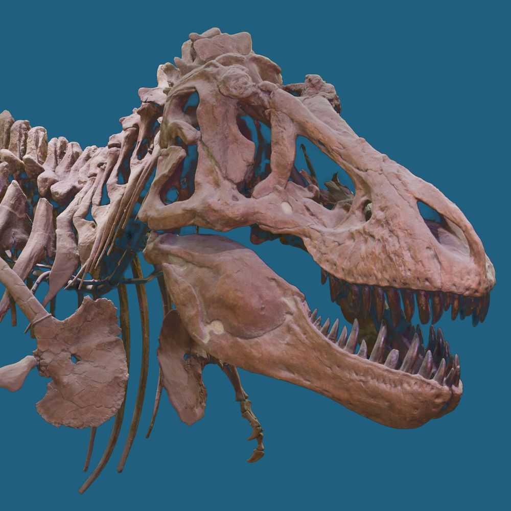
Dinosaurian extinction—asteroid impact or volcanic activity? New research in #GSABulletin concludes that volcanism and resulting environmental degradation was the primary cause.
Read the full article: geosociety.co/4r1VG41
#Volcanology #Chicxulub #ImpactCrater
Image: Figure 4 from the paper.
Read the full article: geosociety.co/4r1VG41
#Volcanology #Chicxulub #ImpactCrater
Image: Figure 4 from the paper.

November 26, 2025 at 10:00 PM
Dinosaurian extinction—asteroid impact or volcanic activity? New research in #GSABulletin concludes that volcanism and resulting environmental degradation was the primary cause.
Read the full article: geosociety.co/4r1VG41
#Volcanology #Chicxulub #ImpactCrater
Image: Figure 4 from the paper.
Read the full article: geosociety.co/4r1VG41
#Volcanology #Chicxulub #ImpactCrater
Image: Figure 4 from the paper.
Reposted by CJC <3 🇺🇦🌾🚜🌾🇺🇦

In what's been an extremely steady month temperature-wise, today will end up the most anomalous day. 4 shy of the record for the date. Overall November will finish a bit cooler than average, though.

November 26, 2025 at 9:56 PM
In what's been an extremely steady month temperature-wise, today will end up the most anomalous day. 4 shy of the record for the date. Overall November will finish a bit cooler than average, though.
Reposted by CJC <3 🇺🇦🌾🚜🌾🇺🇦
The first snows of the season are beautiful, but beware the Unique Hazards of Early Season Cold and Snow!
The main risks are: falling tree limbs from leaf-loaded trees, icy roads catching drivers off guard, and unstable outdoor recreational areas. Slow down and be prepared! weather.gov/safety
The main risks are: falling tree limbs from leaf-loaded trees, icy roads catching drivers off guard, and unstable outdoor recreational areas. Slow down and be prepared! weather.gov/safety

November 26, 2025 at 10:00 PM
The first snows of the season are beautiful, but beware the Unique Hazards of Early Season Cold and Snow!
The main risks are: falling tree limbs from leaf-loaded trees, icy roads catching drivers off guard, and unstable outdoor recreational areas. Slow down and be prepared! weather.gov/safety
The main risks are: falling tree limbs from leaf-loaded trees, icy roads catching drivers off guard, and unstable outdoor recreational areas. Slow down and be prepared! weather.gov/safety
Reposted by CJC <3 🇺🇦🌾🚜🌾🇺🇦

You’ll soon notice a colourful change to the weather alerts issued for your area by Environment and Climate Change Canada (ECCC). Beginning Nov. 26, 2025, the agency will unveil colour-coded alerts across the country. https://ow.ly/jy6h50XykmL

Environment and Climate Change Canada launches new colour-coded Canadian weather alerts - The Weather Network
Environment and Climate Change Canada will use a three-colour system to convey the risk posed by weather hazards across the country
ow.ly
November 26, 2025 at 7:30 PM
You’ll soon notice a colourful change to the weather alerts issued for your area by Environment and Climate Change Canada (ECCC). Beginning Nov. 26, 2025, the agency will unveil colour-coded alerts across the country. https://ow.ly/jy6h50XykmL
Reposted by CJC <3 🇺🇦🌾🚜🌾🇺🇦
Everything is terrible but I hope everybody gets some pie this week. We’re kicking things off with sweet potato (there will be reinforcements).

November 26, 2025 at 11:43 PM
Everything is terrible but I hope everybody gets some pie this week. We’re kicking things off with sweet potato (there will be reinforcements).
Reposted by CJC <3 🇺🇦🌾🚜🌾🇺🇦

What will the weather be like in 1,000 years? A new machine learning model may be able to tell us while using less power than traditional models.
eos.org/research-spo...
Read more in our year-end issue: bit.ly/Eos-Nov-Dec2025
eos.org/research-spo...
Read more in our year-end issue: bit.ly/Eos-Nov-Dec2025

Machine Learning Simulates 1,000 Years of Climate - Eos
The Deep Learning Earth System Model is competitive with CMIP6 models and uses less computational power.
eos.org
November 26, 2025 at 11:45 PM
What will the weather be like in 1,000 years? A new machine learning model may be able to tell us while using less power than traditional models.
eos.org/research-spo...
Read more in our year-end issue: bit.ly/Eos-Nov-Dec2025
eos.org/research-spo...
Read more in our year-end issue: bit.ly/Eos-Nov-Dec2025
Reposted by CJC <3 🇺🇦🌾🚜🌾🇺🇦
Grocery store parking lots are insane right now

November 26, 2025 at 11:50 PM
Grocery store parking lots are insane right now
Reposted by CJC <3 🇺🇦🌾🚜🌾🇺🇦

In today's exciting episode of I Am Learning Japanese Or So Help Me, I glanced up from my computer & realised I could read* my Seven Samurai** print.
*OK I did look up 侍 but I assumed it meant samurai, which it does. Such detective work!
**I mean YES it does say Seven Samurai BUT see alt text...
*OK I did look up 侍 but I assumed it meant samurai, which it does. Such detective work!
**I mean YES it does say Seven Samurai BUT see alt text...

November 26, 2025 at 1:29 PM
In today's exciting episode of I Am Learning Japanese Or So Help Me, I glanced up from my computer & realised I could read* my Seven Samurai** print.
*OK I did look up 侍 but I assumed it meant samurai, which it does. Such detective work!
**I mean YES it does say Seven Samurai BUT see alt text...
*OK I did look up 侍 but I assumed it meant samurai, which it does. Such detective work!
**I mean YES it does say Seven Samurai BUT see alt text...
Reposted by CJC <3 🇺🇦🌾🚜🌾🇺🇦

Back home in Chicagoland on Lake Michigan. November 26, 2025.

November 26, 2025 at 8:53 PM
Back home in Chicagoland on Lake Michigan. November 26, 2025.