


Morgan Barry
@morganabigail.bsky.social
🌊 Meteorologist | 🤷🏼♀️ Obnoxiously overuse y'all | 💁🏼♀️ Specialize in sarcasm
Reposted by Morgan Barry

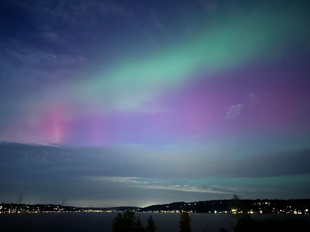
you know what’s extra crazy about this photo… this is the view looking SOUTH
almost the entire aurora arc is SOUTH of Great Falls, MONTANA
almost the entire aurora arc is SOUTH of Great Falls, MONTANA

November 12, 2025 at 4:12 AM
you know what’s extra crazy about this photo… this is the view looking SOUTH
almost the entire aurora arc is SOUTH of Great Falls, MONTANA
almost the entire aurora arc is SOUTH of Great Falls, MONTANA
Reposted by Morgan Barry


Reposted by Morgan Barry

Views of the Aurora Borealis from NWS Seattle!
November 12, 2025 at 1:48 AM
Views of the Aurora Borealis from NWS Seattle!
Reposted by Morgan Barry

Spectacular auroral display - 7:15-7:30p MT from the north end of Erie, CO.


November 12, 2025 at 2:36 AM
Spectacular auroral display - 7:15-7:30p MT from the north end of Erie, CO.
Reposted by Morgan Barry

Sometimes the best events are the unexpected ones. The green embedded within the reds/pinks was the best I’ve ever seen.
From Lafayette, CO.
From Lafayette, CO.

November 12, 2025 at 3:56 AM
Sometimes the best events are the unexpected ones. The green embedded within the reds/pinks was the best I’ve ever seen.
From Lafayette, CO.
From Lafayette, CO.
Seeing the aurora from the office wasn't on my to-do list for tonight. Absolutely wild that it was viewable all the way down in Mobile. 🤩

November 12, 2025 at 3:39 AM
Seeing the aurora from the office wasn't on my to-do list for tonight. Absolutely wild that it was viewable all the way down in Mobile. 🤩
Reposted by Morgan Barry

Day 40 of the shutdown, that’s 2 missed paychecks and part of a third. Federal employees (including my colleagues at the National Weather Service) continue working without knowing when they’ll be paid, or are furloughed. If you know someone affected, please check in on them. #GovernmentShutdown2025

November 9, 2025 at 5:26 PM
Day 40 of the shutdown, that’s 2 missed paychecks and part of a third. Federal employees (including my colleagues at the National Weather Service) continue working without knowing when they’ll be paid, or are furloughed. If you know someone affected, please check in on them. #GovernmentShutdown2025
Reposted by Morgan Barry

I did a post this morning talking about the science of how Doppler weather radar could be used to monitor the impacts from the tragic UPS crash, and how these same concepts can help improve our readiness and response to other non-weather threats. tinyurl.com/55f2cuu3

Positive update on the surface observation contract situation in the Mid-Atlantic, and using weather radar to track the impacts of the tragic UPS crash.
Kalmaegi intensifying as it approaches Vietnam, and next system still looks to be a major threat to northern Philippines.
tinyurl.com
November 6, 2025 at 2:28 AM
I did a post this morning talking about the science of how Doppler weather radar could be used to monitor the impacts from the tragic UPS crash, and how these same concepts can help improve our readiness and response to other non-weather threats. tinyurl.com/55f2cuu3
Reposted by Morgan Barry

A nearly one-week animation for Hurricane Melissa with infrared (IR) imagery on the left and its maximum wind speed (intensity) evolution on the right. The animation briefly pauses at landfall in Jamaica.
IR images extend about 600 km from the center of the storm to illustrate its shape evolution.
IR images extend about 600 km from the center of the storm to illustrate its shape evolution.
October 30, 2025 at 3:03 PM
A nearly one-week animation for Hurricane Melissa with infrared (IR) imagery on the left and its maximum wind speed (intensity) evolution on the right. The animation briefly pauses at landfall in Jamaica.
IR images extend about 600 km from the center of the storm to illustrate its shape evolution.
IR images extend about 600 km from the center of the storm to illustrate its shape evolution.
Reposted by Morgan Barry
NOAA Hurricane Hunters going through this 👇 to collect valuable scientific data to help forecast Hurricane #Melissa. 🧪

THEY. WERE. DOING. THIS. WITHOUT. PAY.
NOAA’s hurricane hunter pilots (and Kermit The Frog hanging from the control panel) fly into Hurricane Melissa.
Extraordinary bravery, saving lives.
(🎥 Cmdr. Danielle Varwig, NOAA Corps).
NOAA’s hurricane hunter pilots (and Kermit The Frog hanging from the control panel) fly into Hurricane Melissa.
Extraordinary bravery, saving lives.
(🎥 Cmdr. Danielle Varwig, NOAA Corps).
October 30, 2025 at 4:36 PM
NOAA Hurricane Hunters going through this 👇 to collect valuable scientific data to help forecast Hurricane #Melissa. 🧪
Reposted by Morgan Barry
Inspired by Brian's chart, I investigated how much time North Atlantic named storms spent at hurricane and at major hurricane strength during 1966-2025.
Blue = proportion for "hurricane time" (category 1-5).
Orange = proportion for "major hurricane time" (category 3-5).
More details in alt text!
Blue = proportion for "hurricane time" (category 1-5).
Orange = proportion for "major hurricane time" (category 3-5).
More details in alt text!

October 30, 2025 at 4:31 PM
Inspired by Brian's chart, I investigated how much time North Atlantic named storms spent at hurricane and at major hurricane strength during 1966-2025.
Blue = proportion for "hurricane time" (category 1-5).
Orange = proportion for "major hurricane time" (category 3-5).
More details in alt text!
Blue = proportion for "hurricane time" (category 1-5).
Orange = proportion for "major hurricane time" (category 3-5).
More details in alt text!
Reposted by Morgan Barry

Annotating a long 3+ day loop of #Hurricane #Melissa from Kingston, #Jamaica radar.
2️⃣ periods appear where an eyewall replacement cycle, #ERC, looked underway. In both cases, inner eyewall stayed intact & outer bands merged, resulting in a larger eye & strengthening after.
A remarkable evolution 🌀
2️⃣ periods appear where an eyewall replacement cycle, #ERC, looked underway. In both cases, inner eyewall stayed intact & outer bands merged, resulting in a larger eye & strengthening after.
A remarkable evolution 🌀
October 30, 2025 at 6:54 AM
Annotating a long 3+ day loop of #Hurricane #Melissa from Kingston, #Jamaica radar.
2️⃣ periods appear where an eyewall replacement cycle, #ERC, looked underway. In both cases, inner eyewall stayed intact & outer bands merged, resulting in a larger eye & strengthening after.
A remarkable evolution 🌀
2️⃣ periods appear where an eyewall replacement cycle, #ERC, looked underway. In both cases, inner eyewall stayed intact & outer bands merged, resulting in a larger eye & strengthening after.
A remarkable evolution 🌀
Reposted by Morgan Barry

NOAA’s hurricane research division staff has been cut from 52 in 2020 to 28 in 2025, almost a 50% cut. They’ve resorted to using volunteers to man the critical radar and dropsonde stations on Hurricane Hunter flights. Senseless cuts in an era of climate change making the strongest storms stronger.

Volunteers Step In to Help Understaffed NOAA Track Hurricane Melissa
www.nytimes.com
October 29, 2025 at 1:45 AM
NOAA’s hurricane research division staff has been cut from 52 in 2020 to 28 in 2025, almost a 50% cut. They’ve resorted to using volunteers to man the critical radar and dropsonde stations on Hurricane Hunter flights. Senseless cuts in an era of climate change making the strongest storms stronger.
Reposted by Morgan Barry

Alrighty, ready to see something really cool? (and maybe a little nauseating)
The evolution of Hurricane Melissa's mesovortices at peak strength.
The evolution of Hurricane Melissa's mesovortices at peak strength.
October 29, 2025 at 8:10 PM
Alrighty, ready to see something really cool? (and maybe a little nauseating)
The evolution of Hurricane Melissa's mesovortices at peak strength.
The evolution of Hurricane Melissa's mesovortices at peak strength.
Reposted by Morgan Barry

Saw something very similar after Hurricane Ian in 2022. New NOAA-funded research published in March found this sort of upwelling from strong hurricanes (causing the aquamarine color) and engorged river runoff stimulate phytoplankton blooms, leading to severe red tide outbreaks.

In the wake of Hurricane Melissa yesterday, runoff flows from the south of Jamaica and into the Caribbean Sea, while upwelling of the seafloor can be seen nearby.
This startling imagery was captured by the NOAA-20 and NOAA-21 polar-orbiting satellites.
This startling imagery was captured by the NOAA-20 and NOAA-21 polar-orbiting satellites.
October 29, 2025 at 10:00 PM
Saw something very similar after Hurricane Ian in 2022. New NOAA-funded research published in March found this sort of upwelling from strong hurricanes (causing the aquamarine color) and engorged river runoff stimulate phytoplankton blooms, leading to severe red tide outbreaks.
Reposted by Morgan Barry

Multi-panel view of the last few days of Hurricane Melissa:
↖️ GOES-19 infrared brightness temp
↗️ GOES-19 visible satellite
↙️ Hurricane hunter planes & flight paths
↘️ Recon-derived flight level wind swath
⬇️ Estimated minimum pressure from recon dropsondes
↖️ GOES-19 infrared brightness temp
↗️ GOES-19 visible satellite
↙️ Hurricane hunter planes & flight paths
↘️ Recon-derived flight level wind swath
⬇️ Estimated minimum pressure from recon dropsondes
October 29, 2025 at 10:14 PM
Multi-panel view of the last few days of Hurricane Melissa:
↖️ GOES-19 infrared brightness temp
↗️ GOES-19 visible satellite
↙️ Hurricane hunter planes & flight paths
↘️ Recon-derived flight level wind swath
⬇️ Estimated minimum pressure from recon dropsondes
↖️ GOES-19 infrared brightness temp
↗️ GOES-19 visible satellite
↙️ Hurricane hunter planes & flight paths
↘️ Recon-derived flight level wind swath
⬇️ Estimated minimum pressure from recon dropsondes
Reposted by Morgan Barry

Remember when social media was a useful tool for assessing damage post-disaster, instead of having to fish through fake photos made with AI garbage?
That was nice.
That was nice.

Black River hospital Jamaica #hurricane #melissa 🇯🇲

October 29, 2025 at 3:45 PM
Remember when social media was a useful tool for assessing damage post-disaster, instead of having to fish through fake photos made with AI garbage?
That was nice.
That was nice.
Reposted by Morgan Barry
Have to say that I agree with Kim here. We obviously are loading the dice with warming SSTs toward systems like Melissa to get more intense - but AFAIK the jury is still out on whether the atmosphere will actually produce more frequent/intense TCs. And I don't see the comms benefit of a "cat 6."
I deeply respect the work that's been invested into exploring our approaches to tracking high-end tropical cyclones, but I can't in good conscience remain silent regarding the Saffir-Simpson hurricane wind scale (SSHWS) and discussion around a so-called category 6. 🧵 [1/5]
October 29, 2025 at 3:25 PM
Have to say that I agree with Kim here. We obviously are loading the dice with warming SSTs toward systems like Melissa to get more intense - but AFAIK the jury is still out on whether the atmosphere will actually produce more frequent/intense TCs. And I don't see the comms benefit of a "cat 6."
Reposted by Morgan Barry

Thanks to some vigilant friends out there, I have a nearly-complete 87-hour radar loop of #Melissa 's approach to #Jamaica. The loop abruptly ends when the radar is lost (either loss of communication with it or loss of the actual structure).
bmcnoldy.earth.miami.edu/tropics/radar/
bmcnoldy.earth.miami.edu/tropics/radar/
October 29, 2025 at 12:03 PM
Thanks to some vigilant friends out there, I have a nearly-complete 87-hour radar loop of #Melissa 's approach to #Jamaica. The loop abruptly ends when the radar is lost (either loss of communication with it or loss of the actual structure).
bmcnoldy.earth.miami.edu/tropics/radar/
bmcnoldy.earth.miami.edu/tropics/radar/
Reposted by Morgan Barry
One factor that supported Melissa reaching this record: an Argo float southeast of Jamaica shows a dramatic decrease in upper-level ocean temperature before (18 Oct) and after (28 Oct) the storm.
My heart goes out to the folks in Jamaica facing this powerful hurricane's numerous hazards today. 💔
My heart goes out to the folks in Jamaica facing this powerful hurricane's numerous hazards today. 💔

October 28, 2025 at 5:27 PM
One factor that supported Melissa reaching this record: an Argo float southeast of Jamaica shows a dramatic decrease in upper-level ocean temperature before (18 Oct) and after (28 Oct) the storm.
My heart goes out to the folks in Jamaica facing this powerful hurricane's numerous hazards today. 💔
My heart goes out to the folks in Jamaica facing this powerful hurricane's numerous hazards today. 💔
Reposted by Morgan Barry
I wish I could like this quoted post 👇 numerous times! Expect plenty of disinformation on social media. Be careful what you share. #Melissa
Echoing colleagues: Think before you (re)post. #Melissa is about to impact a relatively poor part of Jamaica. I doubt we will know the true extent of the devastation for days or weeks.
Information vacuums fill with disinformation. Expect a lot of “breaking wind” on SM.
Map source: World Bank
Information vacuums fill with disinformation. Expect a lot of “breaking wind” on SM.
Map source: World Bank

October 28, 2025 at 4:18 PM
I wish I could like this quoted post 👇 numerous times! Expect plenty of disinformation on social media. Be careful what you share. #Melissa
Reposted by Morgan Barry
#Melissa's landfall intensity of 185 mph/892 mb ties it with the Florida Key's Labor Day Hurricane of 1935 as the record minimum pressure of any TC making landfall *anywhere* the NATL basin. I feel for the residents of #Jamaica 😞
Zoomed in G19 visible meso loop courtesy of @cyclonicwx.bsky.social
Zoomed in G19 visible meso loop courtesy of @cyclonicwx.bsky.social
October 28, 2025 at 5:14 PM
#Melissa's landfall intensity of 185 mph/892 mb ties it with the Florida Key's Labor Day Hurricane of 1935 as the record minimum pressure of any TC making landfall *anywhere* the NATL basin. I feel for the residents of #Jamaica 😞
Zoomed in G19 visible meso loop courtesy of @cyclonicwx.bsky.social
Zoomed in G19 visible meso loop courtesy of @cyclonicwx.bsky.social
Reposted by Morgan Barry

5pm EDT Oct 27th Key Messages for Category 5 #Hurricane #Melissa:
#Jamaica: Remain in your safe shelter & do not venture outside. Catastrophic, life-threatening flash flooding & numerous landslides through Tuesday as Melissa's core moves ashore. hurricanes.gov
#Jamaica: Remain in your safe shelter & do not venture outside. Catastrophic, life-threatening flash flooding & numerous landslides through Tuesday as Melissa's core moves ashore. hurricanes.gov


October 27, 2025 at 9:40 PM
5pm EDT Oct 27th Key Messages for Category 5 #Hurricane #Melissa:
#Jamaica: Remain in your safe shelter & do not venture outside. Catastrophic, life-threatening flash flooding & numerous landslides through Tuesday as Melissa's core moves ashore. hurricanes.gov
#Jamaica: Remain in your safe shelter & do not venture outside. Catastrophic, life-threatening flash flooding & numerous landslides through Tuesday as Melissa's core moves ashore. hurricanes.gov
Reposted by Morgan Barry

From a crewmember on yesterday's Teal 74 mission into now-Category 5 Hurricane #Melissa. As clear of an eye as you will see in the Atlantic basin.
October 27, 2025 at 4:11 PM
From a crewmember on yesterday's Teal 74 mission into now-Category 5 Hurricane #Melissa. As clear of an eye as you will see in the Atlantic basin.
Reposted by Morgan Barry

For those who are curious: Some of the major findings of disaster research over the past half century are that looting and panic are not major factors in most disasters. However, imagining that they will happen greatly hampers response and recovery.
October 27, 2025 at 4:42 PM
For those who are curious: Some of the major findings of disaster research over the past half century are that looting and panic are not major factors in most disasters. However, imagining that they will happen greatly hampers response and recovery.